
Under Loughrigg, Lake District, Winter
A brief respite amongst all the rain.
A brief respite amongst all the rain.
Despite the weather, this week has been as busy as ever. A large part of that is simply that it’s half-term for schools. Still, we figured people would be starting to head back home, so the Lake District wouldn’t be as busy.
Nope.
Our planned circuit of Grasmere was foiled due to every car park being full. Every. One.
So, change of plan. We managed to park further towards Ambleside, right next to the cricket ground, and instead do a small circuit around the Under Loughrigg area in between Ambleside and Rydal.
Still proper bonny. And, happily, signs of spring are starting to appear.
All photos taken on my Sony α7ii using my Pentax SMC 28mm F3.5 and Pentax SMC 55mm f2.0 prime lenses, plus Vivitar “Series 1” 70–210mm f2.8–4.0 zoom lens. RAWs developed in Lightroom, edited and finalised in Photoshop.
Under Loughrigg, Lake District, Winter by Ian Cylkowski is licensed under CC BY-NC-SA 4.0![]()
![]()
![]()
![]()
On the A591 between Ambleside and Rydal, one can enjoy formidable views towards Nab Scar (455 m/1,493 ft).
The flat pasture land in between Loughrigg Fell and the A591 allows for extensive views across to the surrounding fells. There were also plenty of signs of storm damage, with fallen trees and split trunks everywhere. In this case, it allowed for a nice composition towards a highlighted Low Pike (508 m/1,667 ft).
I cropped in tightly for this composition at 210mm to grab these Swaledale ewes milling around a beautiful crag, and subtle hints of the wall of Nab Scar in the background.
A surviving Scots Pine makes for a dramatic composition with the Kirkstone fells in dark shadow behind.
One of the Lake District’s well-known views, often causing sudden brakes by drivers on the A591. Looking towards Rydal, with the Kirkstone fells catching a sweeping lightbeam.
Did you like these photos?

Hull Pot, Yorkshire Dales, Winter
A month since my last post.
A month since my last post.
I do apologise.
The weather in January has been, well, shocking to say the least. We endured three named storms: Henk, Isha, and Jocelyn. Isha, in particular, was one of the most powerful storms the British Isles have seen since 2000.
Additionally, we’ve had periods of below freezing temperatures, resulting in widespread ice.
It’s been… interesting.
Thankfully, the weekend just gone, it was nice enough for us to finally head out. We chose the Hull Pot route from Horton-in-Ribblesdale in the Yorkshire Dales. I had an inkling that there’d still be some snow liggin’ about in the Dales, contributing to a water-saturated landscape and, hopefully, a waterfall flowing into Hull Pot.
And we finally saw it.
All photos taken on my Sony α7ii using my Pentax SMC 28mm F3.5, Pentax SMC 55mm f2.0, and Rokinon 14mm f2.8 ED AS IF UMC prime lenses. RAWs developed in Lightroom, edited and finalised in Photoshop.
Hull Pot, Yorkshire Dales, Winter by Ian Cylkowski is licensed under CC BY-NC-SA 4.0![]()
![]()
![]()
![]()
The characteristic drystone walls of the Yorkshire Dales remained steadfast in the face of all the snow we’ve had recently, resulting in these snowdrifts piled up against them.
Our way forward. We knew on this day that there’d only be 2-3 hours of good light, and boy was it dramatic.
Looking back at where we came from. We were very much on the edge of two weather systems. Conditions over Horton-in-Ribblesdale saw blue skies and puffy clouds, but closer to Pen-y-Ghent it was blowy, dark, and stormy, giving us epic light.
A good sign: A small waterfall where there usually isn’t at Horton Scar. Above, Pen-y-Ghent fights with the dark and stormy clouds.
Further up the bridleway, the site of an extinct waterfall below Pen-y-Ghent, which is now obscured by clouds laden with snow. A burst of sun to our right picks out the details in the land.
And there she is, finally ticked off my bucket list. England’s largest natural hole, Hull Pot, with Hull Pot Beck tumbling down 60ft into the chasm. As mentioned before on this blog, Hull Pot is a large cave where the roof has collapsed, which has resulted in this massive chasm below Pen-y-Ghent. With my ultra-wide 14mm equipped, I was able to capture the entire scene.
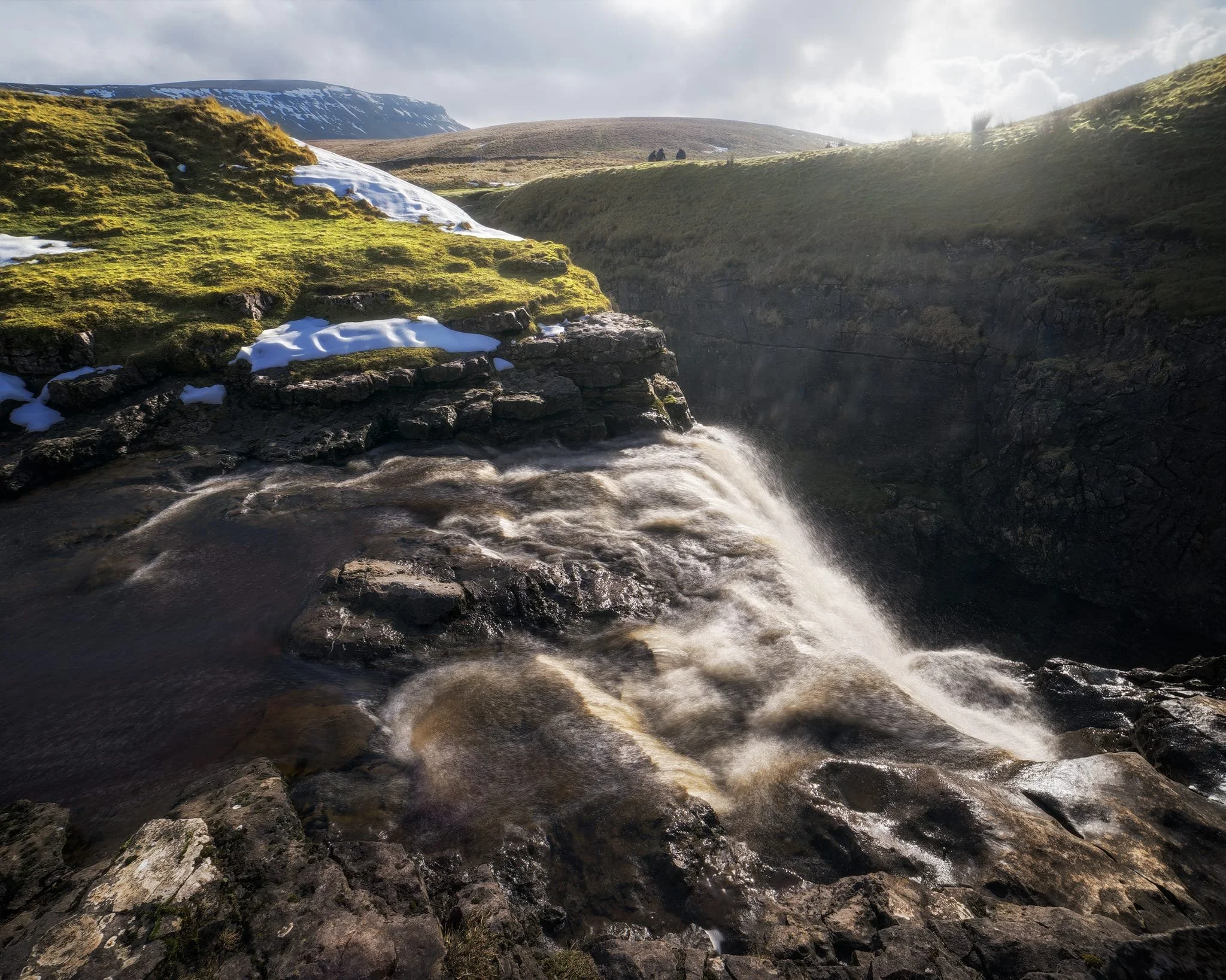
We clambered as close to the waterfall as possible as it crashed over the edge into Hull Pot. As I had no tripod, I shot this with my ultra-wide 14mm at f/22, taking multiple exposures of the same scene. In post, I then averaged the exposures together that gave me that long exposure effect on the water.
Looking up Hull Pot Beck and its many cascades. By the normal way of things, this beck is dry as it usually disappears into the maze of caves beneath Pen-y-Ghent before it reaches Hull Pot. With all the rain and snow we’ve had, the beck was able to complete its route, crashing 60ft down into Hull Pot and re-emerging at the surface nearer Horton-in-Ribblesdale.
A different view of Hull Pot from its eastern end. Two boulders balance precariously on the lip of the pot.
At around 450 m/1,476 ft above sea level, a few snow patches have lingered around the edges of Hull Pot, allowing for some interesting compositional leading lines.
A particularly clean snow patch nearer the falls gives me an idea for a composition involving Pen-y-Ghent in the distance. Fellow hikers milling about the edge of Hull Pot give you a sense of scale of this place.
Heading back down to the village, signs were clear that the best of the day’s light were done as the storm clouds rolled in. We were thankful to get what we did, though.
Did you enjoy these photos?

Grasmere, Lake District, Winter
The winter lurgy has struck.
The winter lurgy has struck.
Following a lovely hike around Ambleside, Lisabet came down with a rather nasty cold and I followed suit soon after.
We’re both at the tail end of this bug now, but with depleted energy levels as can be expected. A crisp, clear, and super cold Sunday greeted us, so we set off towards the impossibly bonny village of Grasmere for a wee waltz around the area.
All photos shot on my Sony α7ii using my Pentax SMC 28mm F3.5 and Pentax SMC 55mm f2.0 prime lenses. RAWs developed in Lightroom and edited in Photoshop.
Grasmere, Lake District, Winter by Ian Cylkowski is licensed under CC BY-NC-SA 4.0![]()
![]()
![]()
![]()
The trail in the direction of Allan Bank enjoys wonderful views towards Helm Crag and Seat Sandal. Here, the latter of the two fells is stroked by golden afternoon light across its flanks.
Across the vale, the craggier yet smaller Helm Crag receives similar treatment from the emerging winter sun.
Heading down the hill towards Goody Bridge, the snowcapped Great Rigg on the right is illuminated. Love the rusty colours some of the Lake District and Scottish fells turn in the autumn and winter.
Expansive views from the Allan Bank trail lead to Seat Sandal being bathed in afternoon winter sun.
A timeless route back to the village centre. There’s no need to hurry.
Did you enjoy these photos?

Ambleside, Lake District, Winter
Temperatures have plunged.
Temperatures have plunged.
The nigh persistent rain of November and December has given way to a sub-zero climate and clearer conditions. Much better.
With a bright Saturday forecast, Lisabet and I ventured into the heart of the Lake District and major tourist hotspot, Ambleside. We wanted to do two walks: one, a small circular of Stock Ghyll Force, the other bigger hike up to High Sweden Bridge.
Despite being in the middle of a blisteringly cold winter in the Lake District, Ambleside was as busy as ever. This town never gets any rest.
All photos taken on my Sony α7ii using my SMC Pentax-M 28mm F3.5 and SMC Pentax-M 55mm f2.0 prime lenses, plus my Vivitar “Series 1” 70–210mm f2.8–4.0 zoom. RAWs developed in Lightroom, edited in Photoshop.
Ambleside, Lake District, Winter by Ian Cylkowski is licensed under CC BY-NC-SA 4.0![]()
![]()
![]()
![]()
A misty shot from the top of Stock Ghyll Force. Made by stacking five landscape 28mm shots, top to bottom, for a wider field of view.
The classic view of Stock Ghyll Force, currently in its more barren winter finery.
After stopping for delicious hot brews at Force Cafe, we followed the trail back down to the town. By the side of the road, this still life-esque scene revealed itself to me, and so quickly I quickly nabbed a composition.
From the town centre, it’s easy enough to find the route to the High Sweden Bridge trail. Given the direction of the low sun, we opted instead to take the trail anti-clockwise, which we’ve never done before, to get more side light.
The old packhorse bridge itself, with my Lisabet providing a nice colour contrast as she strolls across it. As I’ve mentioned on this site elsewhere, the name “High Sweden Bridge” might seem unusual, given this is located in the Lake District, England. The “sweden” aspect originally comes from the Old Norse sviðin (pronounced “swee-thin”), the past participle of svíða, meaning “to burn” or “to singe”. In this context, it refers to the clearing of land by burning.
Looking up Scandale, admiring the light beams scanning across the face of High Pike (656 m/2,152 ft).
Heading back down the higher eastern side of the Scandale valley, I equipped my 70–210mm lens for some tight and distant compositions. Fully zoomed in, I was able to pick out the mist clearing from the summits of the Langdale Pikes, on the right, and Bowfell on the left.
My 70–210mm also has a macro mode, which I used to try and capture these beautiful and tiny Cladonia pyxidata lichen.
Lake District sheep get all the best views.
Did you enjoy these photos?
Colwith Force, Lake District, Autumn
The last of the summer holidays.
The last of the summer holidays.
After a lovely Friday evening in Dentdale, and a glorious Saturday in Kingsdale, we returned to the Lake District on Sunday for a hike to Colwith Force and back.
The weekend saw the advent of a heatwave settling over the British Isles. To counter, we head to Skelwith Bridge early in the morning for cooler conditions and before the majority of summer holidayers were about.
We were rewarded with beautifully moody, misty conditions to start, then as the temperatures rose the mist burned off, swirling around the fell tops and creating dramatic scenery. Just perfection.
All photos taken on my Sony α7ii using my Sony FE 28–70mm f3.5–5.6 OSS zoom and Rokinon 14mm f2.8 ED AS IF UMC ultra-wide prime lenses. RAWs developed in Lightroom using RNI Films’ Kodachrome film profiles, finalised in Photoshop.
Colwith Force, Lake District, Autumn by Ian Cylkowski is licensed under CC BY-NC-SA 4.0![]()
![]()
![]()
![]()
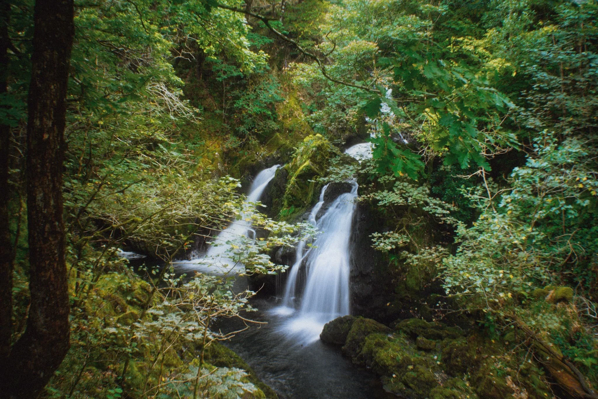
Typically, we start the walk to Colwith Force from Skelwith Bridge. From here we cross the River Brathay and head west. But before crossing the river, we can never resist getting up close and personal with the beautiful Skelwith Force.
Looking upstream from Skelwith Force. You can just about make out the bridge that takes you across the river.
Up and out of the woods around Skelwith Force, we head west where the views started to open up. Well, to a degree. Early morning fog clung to the fell tops, making for moody images.
Looking back down the route we came up. You can just about make out the knuckly profile of Loughrigg but nothing beyond.
After navigating a series of narrow footpaths punctuated with tight kissing gates and stiles, the trail starts to head back down Little Langdale. But before we do, this magnificent composition demands your attention: Wetherlam (763 m/2,502 ft) fighting the swirling mist as the morning sun burns it all off.
Down at the valley bottom we entered Tongue Intake Plantation and picked our way up through the woods to find our main goal for the day: Colwith Force, a double spout waterfall. Evidence of the approach of autumn is all around us.
Some people simply turn around and head back, but we’re fans of following the trail as it ascends up and above the waterfall. From above it, interesting compositions can be found of all the falls before the main double spout.
Though a little dry this time, there’s a lovely series of falls above Colwith Force that deserve attention.
Beyond the upper falls we followed the circular trail back out of the plantation and sought the Little Langdale road back towards Skelwith Bridge. Emerging from the woods, the fells were now clear of the morning mist, revealing their autumnal coats.
Just goes to show the massive difference a change of light conditions can do to the mood and feel of a photograph. Loughrigg and the Grasmere fells beyond, now clearly visible.
Herdwick yows (ewes) and their lambs peacefully graze in the now gorgeous autumnal morning sun. A timeless scene.
Nearing Skelwith Bridge, we could finally see the Langdale Pikes after being consumed by the fog all morning.
Did you enjoy these photos?

Tarn Hows, Lake District, Summer
Summer is upon us.
Summer is upon us.
It’s been a month without any rain, and the temperatures are now consistently in the late teens/early 20s. Rivers and lakes are starting to dry up.
Before things got too crispy and baked, we took a free evening out to Tarn Hows via Tom Gill. Always a good walk, and provides an alternative route to the popular destination that is Tarn Hows. It involves hiking up alongside Tom Gill, occasionally veering off the path to take in a couple of waterfalls. However, they were both almost completely dry.
Tarn Hows was looking incredibly lush and resplendent in its summer finery. One of those evenings that makes you glad to be alive.
All photos taken on my Sony α7ii using my Sony FE 28–70mm f3.5–5.6 OSS zoom lens. RAWs developed in Lightroom for iPad, then edited and finalised in Affinity Photo for iPad.
Tarn Hows, Lake District, Summer 2023 by Ian Cylkowski is licensed under CC BY-NC-SA 4.0![]()
![]()
![]()
![]()
From the upper path around Tarn Hows’ eastern side, my eye catches this fence as a leading line down to the tarn and the Langdale Pikes beyond.
Gorgeous evening light bathes the land and Coniston fells in golden light. In the shade, Herdwick sheep continue their blissful nibbling of the growing grass.
The upper path soon joins the lower one, where we would return back around Tarn Hows. The Grasmere and Fairfield fells peak above the woodland around the tarn.
A panorama, made from 5 vertical images stitched together left to right. I wanted to get all of the dead trees in the frame with the path leading into the distance.
We exited Tarn Hows west via a minor road, and then too came off this road onto a public bridleway, giving us glorious valley views of the Coniston fells.
The road that takes us back home.