Ogwen Valley, Snowdonia, North Wales, Spring
The morning of my 40th birthday.
The morning of my 40th birthday.
We got up before the sun, devoured breakfast, and head straight into the heart of Yr Eryri for one of my favourite areas in the whole of North Wales: the Ogwen Valley.
Dyffryn Ogwen separates two mountain ranges: the Glyderau and the Carneddau. In the Glyderau you can find my favourite peak in all of Wales: Tryfan. She rises 3,010 ft and is often cited as one of the most recognisable mountains in Britain. My favourite compositions of Tryfan involve shooting it from the various falls and cascades of Afon Lloer across the valley.
As an additional bonus, we then enjoyed the Cwm Idwal circuit, taking in one of the most spectacular hanging valleys I know.
The light and weather could not have been kinder.
What a way to see in my 40th year on this planet.
All photos taken on my Sony a7ii using my Vivitar “Series 1” 28–105mm f2.8–3.8 and Rokinon 14mm f2.8. RAWs developed in Lightroom for iPad, then edited and finalised in Affinity Photo 2 for iPad.
Ogwen Valley, Snowdonia, North Wales, Spring by Ian Cylkowski is licensed under CC BY-NC-SA 4.0![]()
![]()
![]()
![]()
I finally got the composition of Tryfan I’ve been after for years. Tryfan at sunrise, with the cascades of Afon Lloer leading the way down the flanks of Pen yr Ole Wen.
Heading back down to the valley floor, a dry stone wall gives me another lovely composition involving Tryfan.
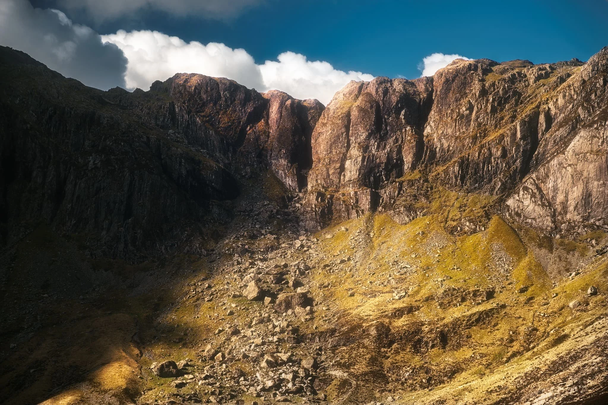
Beyond Tryfan, we climbed up the trail to take the Cwm Idwal circuit. I were very much hoping the light and conditions to be right enough so that the rising sun would illuminate the Idwal Slabs high above the tarn. Here, Castell y Geifr catches the rising sun above Cwm Idwal.
As we pottered about the shore of Llyn Idwal seeking out more compositions, what I hoped for finally happened. The Idwal Slabs, those towering cliffs of crag, starting catching the light. So I lined up this composition.
A tighter composition focusing on the Idwal Slabs. Arguably, Cwm Idwal’s most recognisable feature is the Devil’s Kitchen, or Twll Du (“black hole”) in Welsh. This is a large crack in the cliffs of Cwm Idwal, inside which flows a multi-drop waterfall. The light angle was just right.
As we circumambulated Llyn Idwal clockwise, I kept my gaze locked high on the crags above, watching the light change. As one of the many falls was lit up, I shot this moody photo.
The Cwm Idwal circuit is largely paved, making the going easy. As we neared the apex of the trail, another scene of delicious light demanded by attention.
Walking along the western section of the trail away from the Idwal Slabs, the profile of Pen yr Ole Wen (978m/3,209ft) comes into view. Here, I spot two giant slabs of rock that provide a nice foreground interest as Pen yr Ole Wen gets some lovely morning light.
A glacial erratic nearly blocks the trail. It also gives a lovely foreground interest against the emerging morning light drenching Pen yr Ole Wen.
Nearly at the start of the Llyn Idwal circuit, the tarn is calm and flat enough to give a lovely reflection of Wales’ 7th highest mountain.
Did you enjoy these photos?

Walla Crag, Lake District, Summer
A 4am start.
A 4am start.
The UK is on the cusp of a record-breaking heatwave, kicking in Sunday evening/Monday morning. Even before the real heatwave arrived, Sunday’s temperatures up here in Cumbria were looking to peak at around 26°C. Not only that, summer in the Lake District is easily its busiest time. So what to do?
Wake up before the sun rises and get to our destination before everyone else.
We decided on revisiting the small Walla Crag above Derwentwater, a new favourite after our first venture in autumn last year. Upon leaving the house we were greeted with something we didn’t expect before a heatwave, but probably should’ve anyway.
Rain.
We pulled up at the parking spot, and thankfully it only took 15 minutes or so for the rain to cease. By about 6:40am we started the walk up to Walla Crag.
Although the rain had cleared, it was still completely overcast even as temperatures quickly rose. The sun was not able to break through. So although light conditions were not the best, the views were still utterly magnificent.
All photos taken on my Fujifilm X-T2 using my Vivitar “Series 1” 28–105mm f2.8–f3.8 zoom lens. Shot using the Classic Chrome film simulation, developed in Capture One for iPad, cleaned up in Affinity Photo for iPad.
Walla Crag, Lake District, Summer by Ian Cylkowski is licensed under CC BY-NC-SA 4.0![]()
![]()
![]()
![]()
Across the fields from the Walla Crag path, Low Rigg looks diminutive against the imposing crag face of Clough Head, part of the Helvellyn range.
As we began the steep ascent up to Walla Crag, the views looking back opened up quickly. Here, Blencathra’s beautiful shape is unmistakeable.
The way up to Walla Crag, a short and sharp ascent.
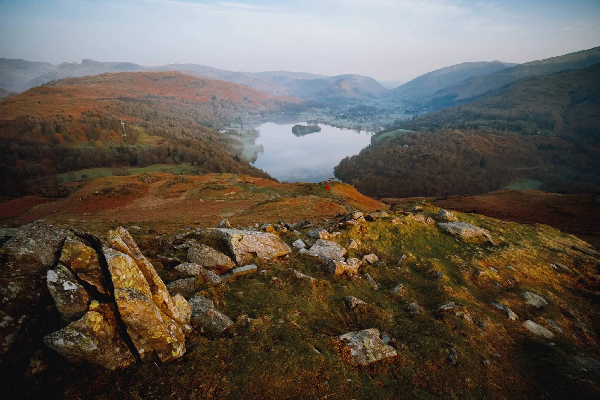
Once up on the more level part of the fell, a small gate through the drystone wall allows you to take the more exploratory route to Walla Crag’s summit. Near the crag’s cliff edge, clear panoramas can be enjoyed across Derwentwater to the Grisedale fells.
Back along the cliff edge towards Blencathra, already there is some heather starting to appear. Give it another month or so for it to be in full resplendent bloom.
The smooth multi-peaked profile of Skiddaw, England’s 6th highest peak.
Walla Crag’s cliff face is lush, chock-full of fern, trees, heather, and loads of other flora. Lisabet discovered a small bilberry bush, and helped herself to a couple of the tart berries.
The summit of Walla Crag! Looking back north towards Skiddaw, a dominant presence on the Keswick skyline.
Derwentwater looks dry, with a couple of new islands becoming exposed as the water level drops.
One final composition from the summit, this time featuring Blencathra’s curved forms.
Walking towards the Jaws of Borrowdale.
Probably my favourite composition of the day. The drystone wall keeps livestock out of the Walla Crag area, allowing flora to flourish. In the distance is Derwentwater’s southern tip with the Borrowdale fells high above.
The other side of the same wall, featuring more of the Catbells ridge.
On the way back down the fell, I couldn’t resist revisiting this composition.
Pretty happy with how this shot of a family of fell ponies came out.
Did you like these photos?
Loughrigg Fell, Lake District, Spring
Step 1 of the UK Government’s Spring 2021 COVID-19 plan has been completed.
Step 1 of the UK Government’s Spring 2021 COVID-19 plan has been completed.
From Monday 29th, more people can now meet outside, outdoor recreation activities are permitted again, and the “Stay at home” ruling has relaxed to “Stay local”.
I’ve taken some time off work before and after the Easter weekend in order to recuperate. I’ve been feeling burned out for quite a while now. So what did we do on our first full day off?
We woke up at 5am for a sunrise hike up Loughrigg Fell (335 m/1,099 ft).
We’ve only ever been up Loughrigg once before, again for sunrise, back at the tail end of summer 2020. The fell really isn’t that tall in Lake District terms, but it covers a decently large area, which opens up a wide variety of views to shoot.
On this hike, we were greeted with the remnants of a temperature inversion clinging to the waters of Grasmere as well some of the valley bottoms. We only saw three other people around the fell; in fact, there were more sheep! Couldn’t have asked for better conditions.
All photos taken on my Fujifilm X-T2 using my three lenses: a Samyang 35mm f/1.2, a Laowa 9mm f/2.8, and an adapted Pentax SMC 55mm f/2.0. Photos developed using RNI’s Kodachrome film profiles.
The calm waters of Grasmere, reflecting Helm Crag (405 m/1,329 ft) and Seat Sandal (736 m/2,415 ft). The remnants of a temperature inversion lent a beautiful misty atmosphere.
We wound our way up through Deerbolts Wood to find the main footpath up Loughrigg Fell.
As we began ascending the main footpath up Loughrigg Fell the views quickly opened up. From Loughrigg Terrace the temperature inversion was more visible, and I couldn’t resist this composition of the mist clinging to the valley, with Nab Scar (455 m/1,493 ft) looming above.
Although the sun had risen, from our location it was still trapped behind a low bank of cloud. By this point of the hike up Loughrigg, the sun was beginning to peek above the clouds, its light glowing through this solitary tree resolutely rooted to the fellside.
More sunrise light as the sun rose above the cloud base. We passed this occupied tent on our way up. A nice spot, for sure, but technically they’re not allowed to wild camp.
Beautiful Wetherlam (763 m/2,502 ft) finally receiving some of the sunrise light, as the mist in the valleys starts to burn off.
Nearly at the summit of Loughrigg, we look back to this cracking view of Grasmere, its namesake village, and the Central Fells.
The summit of Loughrigg Fell. With the sun clearly above the clouds, beautiful golden light drenched across the rolling folds of the fell.
A Herdwick ewe, enjoying the morning light. Not a bad view to chill out whilst chewing the cud, eh?
Another Herdwick ewe, lower down the slope. It’s a sheep’s life in the Lake District.
This Herdwick ewe, closer to us, was much more vocal. Probably warning the others about our presence.
The summit of Loughrigg is wonderfully craggy. My ultra-wide 9mm lens was able to fill the frame with this crag and also take in the extensive view towards Windermere.
We carefully picked our way back down the wet northern slopes of Loughrigg, stopping for the occasional photo along the way. This area of the fell was extensively mined for slate in the Victorian era, now long abandoned. Its remnants make for interesting compositions towards Nab Scar and Rydal Water.
This is Rydal Cave, formerly Loughrigg Quarry, and completely man-made. You can often find ducks and fish milling about in the shallow pools of the cave.
It’s not often one gets Rydal Cave all to oneself, so we ventured in for some photos.
Now back onto Loughrigg Terrace, the going is much easier as we saunter gently back towards the car through White Moss Woods. This particular aspect of Loughrigg Fell is called Ewe Crag.
An old barn, long fallen into disrepair and nature quickly reclaiming it.
Into White Moss Woods with gorgeous golden morning light streaming in.
Still a fair bit of colour in the woods. Soon, White Moss Woods will be absolutely full of bluebells. Give it a month or so.

Quiraing, Isle of Skye, Autumn
Alongside the Storr, the Quiraing is one of those places on Skye that ignites your imagination and takes your breath away.
Alongside the Storr, the Quiraing is one of those places on Skye that ignites your imagination and takes your breath away.
Much like the Storr, the Quiraing is part of the Trotternish landslip, the longest such feature in the British Isles. Whilst the Storr marks the highest point of the Trotternish landslip, the Quiraing marks the northernmost summit at Meall na Suiramach (543 m/1,781 ft). The Quiraing is also, unlike the Storr, still slipping; apparently the road at the bottom of the Quiraing near Flodigarry requires repair every year as the land continues to move.
The name comes from Old Norse, the language of the Vikings: Kví Rand, which can be translated as “round fold”. This could refer to the fold just below the summit of Meall na Suiramach, which hides a flat plateau known as The Table (roughly around here), where cattle could be hidden. In fact the Quiraing is home to quite the variety of weird and wonderful rock formations and their characterful names, such as The Needle and The Prison.
Lisabet and I woke up nice and early to get to the Quiraing for sunrise. We knew there’d be fewer people, as the Quiraing is quite accessible and very popular, but we were also expecting rain after sunrise. As a result, we were treated to a wonderful light show as the sun rose over the sea, not long followed by a weather system that moved in and completely drenched us.
Worth it.
All photos shot on a Fujifilm X-T2 with both the Samyang 35mm f/1.2 and Laowa 9mm f/2.8 lenses using a customised Pro Negative Standard film profile.
Both being significantly fitter now, we decided upon arrival to start hiking up the southern edge of the Quiraing that leads towards Dùn Dubh (396 m/1,299 ft). Pink pre-dawn light starts to appear in the sky.
As dawn breaks the sunrise light show gets better and better. This image is made of 6 landscape photos shot on a 35mm/f1.2 lens, stacked top to bottom and merged into a “bokehrama”. The hill on the left is called Cleat (336 m/1,102 ft).
My lovely Lisabet capturing the wonderful sunrise.
As we clamber back down the ridge we cross a meandering little stream, which I use as a leading line towards the northern section of the Quiraing. Those rock formations just don’t seem real.
Now following the northeastern ridge of the Quiraing, we found a lovely load of heather still largely in bloom. I composed this ultra-wide view of the Quiraing as I liked the way the curving cliff mirrored the curve of the road below.
A well-known and famous composition of the Quiraing, yes I admit it. But when I spotted that little tree growing out of the side of the cliff I couldn’t resist a photo. Also, the light on the Quiraing was so good.
At this point of the hike the sunlight was getting stronger and stronger, casting intense golden light on the land. When composing this shot on my Laowa 9mm I noticed that at certain angles the lens would flare quite drastically. Rather than avoiding it, I decided to deliberate include flare for this photo of the path through the Quiraing.
The sun had finally escaped above the bank of cloud that clung to the sea, drenching the Quiraing in intense golden light.
When I turned back for a composition of the route we had taken, I saw this storm moving in behind the Quiraing… so we decided to turn back and head towards the car. 5 minutes after shooting this photo we promptly got soaked.
Check out my Isle of Skye portfolio while you’re at it.

Glen Brittle, Isle of Skye, Autumn
Skye has one or two “hotspots” that are vastly more popular for visitors.
Skye has one or two “hotspots” that are perhaps vastly more popular for visitors than other areas around the island. The Storr might be considered one of those hotspots.
Another would be the Fairy Pools of Glen Brittle.
The last time I checked out the Fairy Pools was way back in 2013, when we first explored the Isle of Skye. I was instantly beguiled by the variety of cascades and waterfalls, creating pools of brilliant turquoise as a result of the crystal clear water and reflecting the colours of the rocks.
As you climb up the path alongside, the backdrop is increasingly dominated by the jagged skyline of the Black Cuillins, particularly the peak of Sgùrr an Fheadain (689 m/2,260 ft) and the fissure that runs down it known as Waterpipe Gully.
After capturing all kinds of compositions around the Fairy Pools, noting the light changes as the sun rose above the Black Cuillins, we ventured further down Glen Brittle to check out some of the less-visited cascades and falls. In particular, after a short but steep hike, we were floored to discover a sudden gorge dropping beneath our feet and a huge waterfall falling into it, with the Black Cuillins framed above. An absolutely incredible sight.
All photos shot on my Fujifilm X-T2 with both a Samyang 35mm f/1.2 and a Laowa 9mm f/2.8 lens using a customised Pro Negative Standard film profile.
The shooting started almost immediately after parking up, as we could see the rising sun just starting to peak above Sgùrr an Fheadain, casting beams of light around the mountain. Incredible scenery.
As we hiked further up the path the hill fog started to burn off, revealing some of the tops of the Black Cuillins. This peak in particular is Sgùrr Thuilm (meaning “Rocky peak of the hillock”) and measures 881 m/2,890 ft high.
This is one of the bigger waterfalls of the Fairy Pools. The photo is comprised of 6 landscape frames, shot top to bottom, and merged into a single “bokehrama”.
At this point of the river, known as Allt Coir’ a’ Tairneilear, the bigger waterfalls give away to a myriad of criss-crossing smaller cascades, each creating their own little pools of brilliant turquoise. The rising sun was getting above the Black Cuillins, casting strong golden light on the carved rock forms of the river.
Probably my favourite composition from the whole hike, tracing the winding carved rock through to the falls and the mountains beyond as the sun highlights their forms.
One of the last cascades on the Allt Coir’ a’ Tairneilear before the river flattens out directly underneath Sgùrr an Fheadain. Beautiful golden light picks out the various ridges and shelves of rock around the river.
My lovely Lisabet, on our way back down the valley.
The hills that form the western side of the Glen Brittle valley, catching the post-sunrise light. Right to left: Beinn a’ Bhràghad (459 m/1,505 ft), Beinn Staic (412 m/1,351 ft), and An Cruachan (435 m/1,427 ft).
Taking one last look at Sgùrr an Fheadain and the rest of the Black Cuillins as the hill fog clears further.
Further down Glen Brittle, towards its terminus as it pours out into Loch Brittle, you can hike up alongside less-visited rivers and their own waterfalls. Near the Glen Brittle Youth Hostel we park for a hike up the river Allt Coire Banachdich, as it pours down from the western flanks of the Black Cuillins. 300+ ft up the river this view suddenly opens up, revealing a deep and sheer gorge that the river has carved, now dropping 150+ ft as the waterfall known as Eas Mòr. A truly awe-inspiring site, especially with the western Black Cuillins above.
The last of the season’s heather provides a nice colour contrast against all the greens and golds. The top of Eas Mòr catches the light before plunging 154 ft into the gorge. Above, the peak of Sgùrr Dearg (985.8 m/3,234 ft, meaning “Red peak”) dominates.

Tarn Hows, Lake District, Autumn
Our new jam is sunrise hikes.
Our new jam is sunrise hikes.
After summiting Loughrigg Fell as the sun rose up last weekend, we ventured out for another sunrise hike. This time we started from Yew Tree Tarn near Coniston, and hiked up through the woods in a ravine called Glen Mary to find a delightful succession of waterfalls called the Tom Gill falls. Following the gill, you eventually pop out at Tarn Hows, where we were greeted with crystal-clear reflections and the sun rising up above the surrounding fells.
We took the Tarn Hows circular trail anti-clockwise to hitch up onto the crags above the tarn known as the Howgraves crags. Lots of cuddly Herdwick sheep were happily grazing around the crags here. We then rejoined the trail anti-clockwise before exiting at its northwestern junction towards the Cumbria Way. This takes you back towards the A593, north of Yew Tree Tarn, where we followed the path alongside the road before returning to the car.
Incredible views, peaceful sounds, gorgeous light, and cuddly sheep. What’s not to love?
All photos shot on a Fujifilm X-T2 with my new Samyang 35mm f/1.2 lens using a customised Classic Chrome film profile.
A fairly still Yew Tree Tarn with the first of the day’s light just starting to hit the crags of Holme Fell (317 m/1,040 ft). The last time we saw this tarn was early summer, and it was completely dry.
The first of the cascades known as Tom Gill falls. Starting to get some autumn colours in the Lake District now.
The main waterfall of the Tom Gill falls, dropping 30 ft. This is a vertorama, or even a “bokehrama”, comprised of six landscape frames at 35mm/f1.2, stacked top to bottom.
Looking back to my lovely Lisabet as we continue up the Glen Mary ravine.
Eventually we pop out of the ravine onto Tarn Hows, with crisp reflections and golden sunrise light.
Perfect reflections of the south bank of Tarn Hows.
Another vertorama comprised of three landscape shots at 35mm/f1.2, stacked top to bottom, showing the glowing woods we came out of.
A beautiful Herdwick ewe, giving me that characteristic quizzical and curious look from her perch.
As we climb up the crags above Tarn Hows another Herdwick ewe emerges from the bracken, giving me a look. Behind her is the glowing face of Wetherlam (763 m/2,502 ft).
One or two people have arrived on the Tarn Hows trail as more sunlight illuminates the fells and woodlands. High above is the Old Man of Coniston or Coniston Old Man (802 m/2,632 ft), the highest of the Coniston fells and once the highest peak in Lancashire before the formation of the county of Cumbria.
The Langdale Pikes peep just above the woods around Tarn Hows. This is a 4-shot vertorama, stacked top to bottom, at 35mm/f1.2.
Looking down to Tarn Hows from the crags above it. Beyond are the Grasmere Fells.
An 8-shot vertorama, highlighting this naked tree as it catches the light.
Another flock of Herdwicks grazing in the woods around Tarn Hows, with the rising sun breaking through the canopy.
We exit the Tarn Hows circular trail onto the Cumbria Way, which rises gently towards the A593. Along the way we’re treated to sweeping views of the Coniston Fells and their autumn colours. This is a 3-shot vertorama, stacked top to bottom, each shot a landscape frame at 35mm/f1.2.
Where there’s a winding dry stone wall, there I am trying to photo a composition.
On the way back home we stop off at Staveley for a bacon butty and a flat white at More? Bakery.
She loves a good brew.