
Dent, Yorkshire Dales, Autumn
Time to revisit an old friend.
Time to revisit an old friend.
With fairer conditions promised, we head out as soon as I finished work on Friday evening. We’d managed to book a table at the Meadowside Cafe in Dent, but beforehand we wanted to get reacquainted with this magical valley.
Dent is small, old village situated in a valley of its namesake: Dentdale. The valley is narrow and steep-sided, with Aye Gill Pike (556 m/1,824 ft) looming above Dent on the northern side and Great Coum (687 m/2,254 ft) rearing up behind.
The village itself is gorgeous, featuring buildings that are three to four centuries old, a cobbled village centre, gorgeous old church, and more.
We relished a light-hearted trek towards the south along the slopes of the fell, aiming to explore the Dancing Flags at Flinter Gill. The Dancing Flags are a vast spread of flat, naturally occurring stone slabs, which for centuries were employed by local weavers to 'waulk' their freshly woven cloths, traditionally referred to as 'webs'. 'Waulking' involved the process of thoroughly soaking the cloth before stepping on it barefoot, leading to a minor shrinkage and 'felting up' of the fabric. This resulted in a much denser and consequently warmer material. This technique was once universally adopted and was often referred to as 'dancing the web' in various regions, thus giving the stones their name.
After wandering around the village, it was time to pack the gear away and enjoy a fabulous meal at Meadowside Cafe.
All photos taken on my Sony α7ii using my Sony FE 28–70mm f3.5–5.6 OSS zoom lens. RAWs were developed in Lightroom for iPad using RNI Films’ Kodachrome film profiles, then finalised in Affinity Photo 2 for iPad.
Dent, Yorkshire Dales, Autumn by Ian Cylkowski is licensed under CC BY-NC-SA 4.0![]()
![]()
![]()
![]()
From the main village car park, there were already tremendous views over the old sandstone houses to Middleton Fell and the wall of Combe Scar.
This is where Flinter Gill tumbles down the Dancing Flags. At least, where it normally does. Despite all the rain we saw in July and August, Flinter Gill was exceptionally dry.
From near the Dancing Flags, the views back down to Dent village were exceptional.
It will be nice to shoot the Dancing Flags when there’s loads of water pouring down. Of course, that will also make it harder to get close.
Heading back down into the village, we enjoyed the almost timeless scenes that Dent presents around nearly every corner.
Save for the car and satellite dish, this scene could be from 1923, rather than 2023.
Not a bad backdrop for a football game, eh?
Some of these houses in Dent date back to the 1600s. One such building was the birthplace and home of Adam Sedgwick, the “father” of British geology.
A rusty barn provides a beautiful colour contrast to all the surrounding greenery. Above, a beam of light scans across the fellside of Aye Gill Pike.
Crossing the 18th century Church Bridge with staggering views towards Aye Gill Pike.
Back over towards the northwestern side of the village, the road serves as a leading line towards Helms Knott as the light starts to fade.
The signage may have changed over time, but this scene will have been relatively unchanged for a century or so.
Stone Close is a 17th century tea room, it’s walls thick and whitewashed. The cobbled road points deeper into the village.
St. Andrew’s Church, with Aye Gill Pike behind it. The church dates from the 12th century, with the tower added in the 18th century. It was restored in the late 1800s.
The George & Dragon hotel and pub, rebuilt in the 19th century. To the right, a home maintains its original Martins Bank Ltd. signage. This was bank company was formed around 400 years ago, and had a significant presence throughout the north of England. It was bought by Barclays in 1969.
Did you enjoy these photos?
Clougha Pike, Forest of Bowland, Lancashire, Summer
The last few weeks have been… tough.
The last few weeks have been… tough.
Not long after our hike to and around Stockghyll Force, I managed to acquire some form of vertigo for a few days, which was decidedly unpleasant. The following week, my lovely Lisabet came down with a rather nasty summer cold, and I managed to fall down the stairs, spraining my wrist and severely bruising my butt. Then the week after, I caught Lisabet’s cold.
Yeesh.
Finally though, we were both fit and healthy, ready to get back out in nature. Following wise counsel from our nature expert friend, Andrew, we embarked on a completely new hike for us: the Clougha Pike circular.
Clougha Pike is the westernmost summit in the Forest of Bowland Area of Outstanding Natural Beauty. Many peaks in the Forest of Bowland are gristone fells surrounded by heather-covered peat moorland, blanket bog, and deep wooded valleys. Clougha Pike is no different, though its southern face drops away dramatically to the valley floor, and is clearly visible from most areas around Lancaster.
I ended up being in rather a lot of pain for this 10km hike. For reasons unknown to me, I slowly developed a blistering headache as the hike went on. This was paired with a sore neck (from having to look down at my footing a lot), sore knees (an every day occurrence), and painful feet (soles in my boots are now too thin).
Oh also, around the lower areas of the walk, having to deal with all the sheep flies and deer flies.
Despite all of this, the hike was gorgeous. The heather was in full bloom, covering the land and fells in carpets of mauve flowers. We were also experiencing the tail end of Storm Betty, so the higher we ascended the more the 50 mph winds punched our bodies.
All in all, it made for an epic day, and crackin’ photos.
Photos taken on my Sony α7ii using my Sony FE 28–70mm f3.5–5.6 OSS zoom lens. RAWS developed in Lightroom for iPad using RNI Films’ Fortia SP film emulation, then finalised in Affinity Photo 2 for iPad.
Clougha Pike, Forest of Bowland, Lancashire, Summer by Ian Cylkowski is licensed under CC BY-NC-SA 4.0![]()
![]()
![]()
![]()
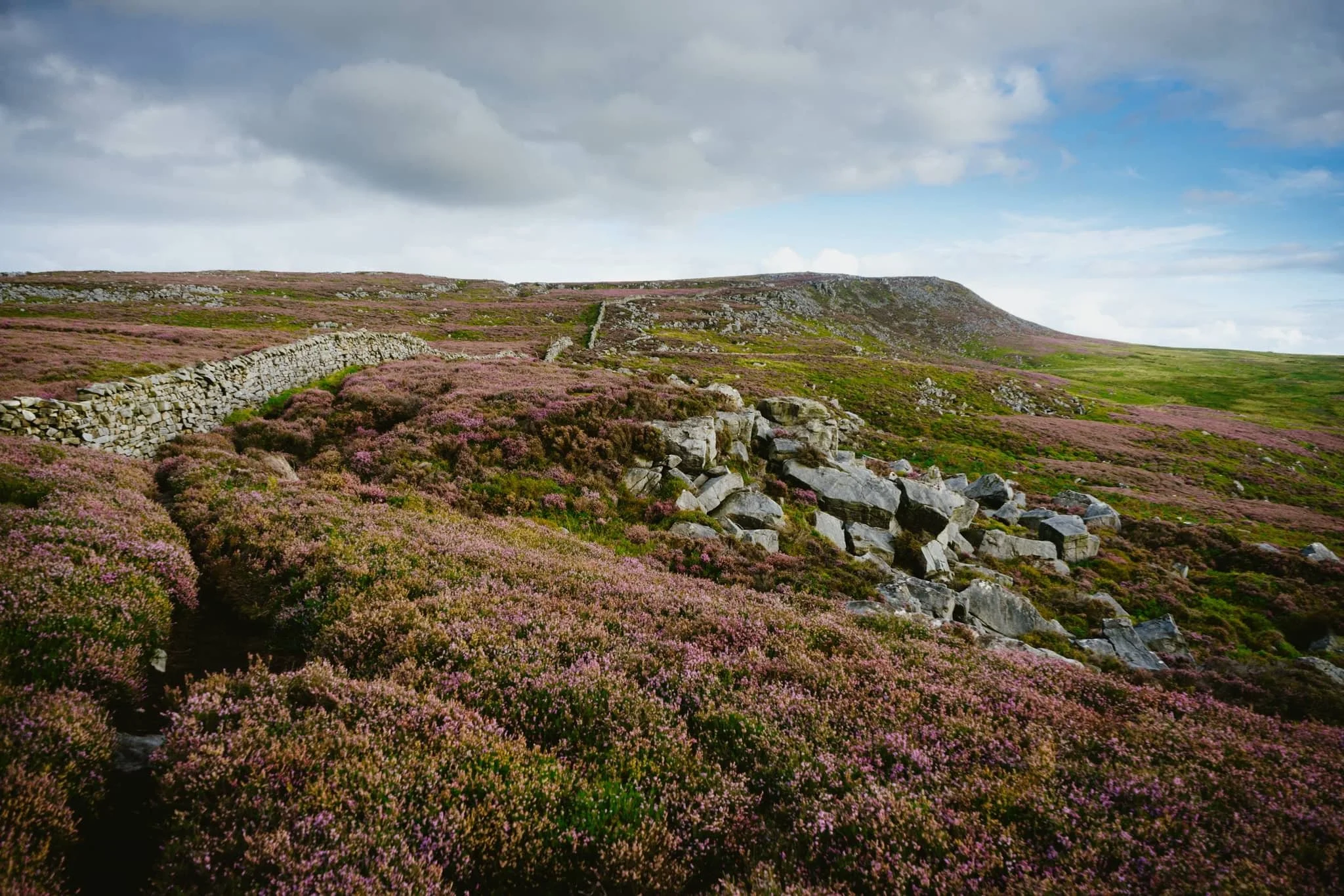
Just a few yards from the car park and already we could see the extent of all the pinky purple heather blooming in the area.
This trail is the more direct route up to Clougha Pike. But for our hike, we chose a more circular clockwise route, skirting around the old quarries and heading towards Littledale.
The colour contrast between the heather and the grasses was proving too hard to resist.

A small scene of a gristone boulder being enveloped by all the heather, fern, and other moorland vegetation.
Increasingly I delight in finding, composing, and shooting these more intimate scenes in nature.

Miles upon miles of heather moorland give way to the lower folding valleys near Quernmore.
This point marked the beginning of our ascent of the fellside above Littledale, the site of a former quarry.
After crossing the infant River Conder via a concealed viaduct now known as Ottergear Bridge, we continued ascending the fellside above Cragg Wood. In the distance, Caton Moor’s windfarm catches the emerging light.
The trail gently lowered back down the fellside, but not before I captured this delightfully bucolic English view.
Another ascent ahead of us, the time the proper one that takes us all the way up to the Clougha Fell moorland plateau. The cascades of Sweet Beck presented a lovely little composition.
A swaledale yew enjoys the view from the fellside above Sweet Beck, with Caton Moor still drenched in light.
As we start ascending the back of Clougha Fell, the greens of the grass is gradually replaced the pinks of heather and the dark tones of peat, punctuated with boulders of gritstone.
The Caton Moor windfarm still getting soaked in afternoon light. In the distance, the dark clouds press down on the southwestern fells of the Yorkshire Dales.
After tacking the tricky and occasionally boggy trail up the back of Clougha, we finally joined the gravel shooter’s track and the moorland plateau. Rather then heading straight for the summit, we looped around to check this Andy Goldsworthy sculpture.
Of course, we had to take turns clambering into the “chambers” for some photos. The nice thing is, in the 50+ mph winds, these chambers were a nice respite from being constantly wrestled by the wind.
Making our way onto Clougha Fell, I had lots of fun making compositions from all the gritstone formations dotted about everywhere, such as with these boulders and the Yorkshire Dales Three Peaks in the distance.
A gritstone platform with solitary boulders, wrapped in heather, provided a nice scene towards Caton Moor and the dark fells in the distance.
It’s not quite Joe Cornish levels of composition skill, but I’ll get there one day.
A solitary gritstone boulder perched on the moorland plateau serves as a nice subject as it catches the light beneath the stormy skies.
From the summit of Clougha Pike, a mere 413 m/1,355 ft above sea level. Nevertheless, the views are gorgeous. From the summit we can see all the way across the Lune valley, towards Morecambe Bay.
From the summit, our way back down was immediately apparent. It was going to be rocky and steep.

100 m or so below the summit of Clougha Pike, a patch of smoothed gritstone boulders interspersed with heather provide me with another tasty composition.
From below Clougha Pike’s southern face, it’s easy to see how this is such a distinct and recognisable hill from many miles away.
A blast of light from the racing stormy clouds pulls all the gorgeous textures and colours from this scene.
One last look back at Clougha Pike, with heather everywhere, but we continued the descent down into the woodland toward the car park, fighting flies all the way.
Did you enjoy these photos?
Morecambe & Heysham, Lancashire, Summer
After a thunderstorm, you need to get those vast and expansive views.
After a thunderstorm, you need to get those vast and expansive views.
On the Saturday, the Met Office issued a Yellow Warning of thunderstorms and torrential downpours. This was very much needed as temperatures were starting to creep up to the mid 20’s again with 90%+ humidity.
If there’s one thing a thunderstorm is really good at it’s clearing the atmosphere. So, on the Sunday, we decided that solid hike along the Morecambe Bay coast, from Morecambe to Heysham and back, was needed. The views across the bay to Cumbria and the Lake District fells are always welcome. Plus, we knew we would have limited time before the next load of thunderstorms arrived.
I decided to equip relatively minimally; just my camera, Sony 28–70 and Vivitar “Series 1” 70–210mm for those super tight and zoomed in compositions.
The views, and the weather, were glorious.
All photos taken on my Sony α7ii using my Sony FE 28–70mm f3.5–5.6 OSS and Vivitar “Series 1” 70–210mm f2.8–4.0 zoom lenses. RAWs developed in Lightroom for iPad using RNI Films’ Portra 160 film emulation, then a little bit of finalisation in Affinity Photo 2 for iPad.
Morecambe & Heysham, Lancashire, Summer by Ian Cylkowski is licensed under CC BY-NC-SA 4.0![]()
![]()
![]()
![]()
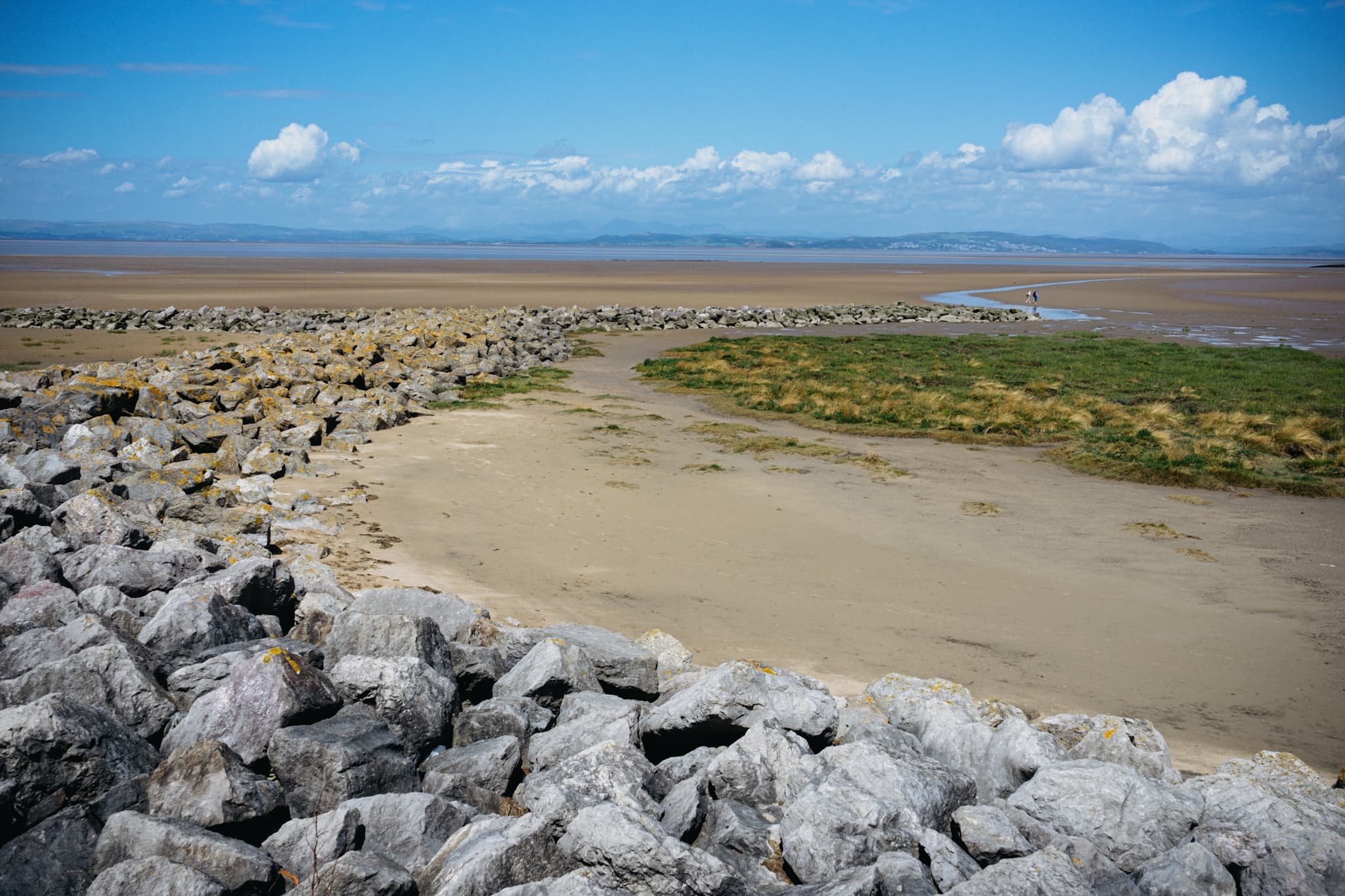
Want sweeping and expansive views for mountains in the distance? Morecambe Bay is where you need to be. Anywhere with access to the Bay will do, but for this walk we chose the town of Morecambe itself.
This is the 14 m tall Hook Beacon, signalling the location of West End Gardens at Morecambe Bay. It was conceived by Broadbent Studio in collaboration with local school pupils.
A man and his dog, watching the world go by.
We started the walk 1-hour after low tide, so the sea was still miles out. Families and couples alike were enjoying the sensation of wet sand on their feet and sea air in their faces.
I decided to equip my 70–210mm lens for some super-zoomed in compositions across the bay to Cumbria.
A lovely mural that I can never resist taking a shot of.
Nice and clear, the Coniston Fells in the Lake District, 25 miles away.
One of numerous breakwaters along Morecambe. This is Grosevenor Breakwater, with Black Combe (600 m/1,970 ft) rising in the distance.
It’s always nice to see people soaking in the vibes of the day and taking in the immense views that Morecambe has to offer.
South beyond the town of Morecambe, ancient Heysham comes into view, resting on a small hill above the Bay.
St. Peter’s church. Christian worship has been regularly practised at the site for over 1,000 years.
The graveyard behind the church enjoys spectacular views across the Bay.
Trees in the graveyard remind us of the passing of time beyond our own horizons.
The ruins of St. Peter’s chapel, dating from around the 8th or 9th century. It gives me vibes of a portal to another world.
A group of six stone-hewn tombs dating from around the 11th century. Each tomb has an associated “socket”, which was probably where a wooden cross would be inserted.
At Half Moon Bay, just before Heysham Nuclear Power Station, one can find the marvellous SHIP sculpture by Anna Gillespie.
The ship's hull is mounted with two opposing figures at each end. One faces "new" Heysham, the Nuclear Power Station, and the other faces "old" Heysham, the ancient monument of St Patrick's Chapel.
The sculpture "celebrates Morecambe Bay's landscape and maritime heritage, and reflects the importance of seaborne trade in bringing news, innovation and shaping the character of the area."
Heading back to Morecambe, I couldn’t resist nabbing the colour contrast of pink and green courtesy of these flowers.
The way back to Morecambe, with plenty of other peeps enjoying the day out in the glorious sunshine.
This gentleman was raising people’s spirits with tunes from his pocket trumpet. He was also kind enough to pose for a photo or two and give us a rendition of “Bring Me Sunshine”, an appropriate tune for the town of Morecambe.
Did you enjoy these photos?
Longridge Fell, Lancashire, Summer
Being in nature with your best bud is one of life’s greatest treasures.
Being in nature with your best bud is one of life’s greatest treasures.
I recently had the privilege of heading Down South (and by Down South, I mean, Preston) to spend a weekend with my best mate, Fie. With the prospect of a gloriously sunny British summer’s day ahead, we decided on a wee little excursion up Longridge Fell, east of Preston.
I’ve not been up Longridge in, perhaps, over a decade. The one and only time I hiked Longridge Fell was to capture the sunset from the summit with another good friend of mine, Bamber. This was very early on in my photography journey, so I was very unsteadily shooting HDR photos.
In fact, here’s the photo:
This was shot on the 7th August, 2012.
So yeah, it’s been nearly a decade.
Longridge Fell is the most southerly hill in England that has the word “fell” in its name. As you may have read previously in this blog, “fell” in Northern English dialects refers to a hill or a mountain, and can be traced from the Old Norse word fjall, which means “mountain”.
The fell’s name is quite literal as it truly is a long ridge, rising from the town of Longridge to its summit in 4.5 miles. Researching Longridge Fell caused me to learn a new word, which I’m always happy with: cuesta. This is a Spanish word and geographically refers to a hill or ridge with a gentle slope on one side, and a steep slope on t’other, which Longridge Fell definitely fits.
On this day, and for this walk, we started from Jeffrey Hill car park, which is already 200m-ish a.s.l. Only another 150m worth of ascension was needed to reach the summit.
The day was gloriously clear with nary a cloud in the sky. Like in Cumbria, Lancashire has seen barely a drop of rain in a good month or so. As a result, the fell—though normally boggy—was remarkably dry. This didn’t stop Fie from managing to sink one of her shoes into a surprise bog…
All photos shot on my Sony α7ii using my Sony FE 28–70mm f3.5–5.6 OSS zoom and Vivitar “Series 1” 70–210mm f2.8–4.0 zoom lenses. RAWs developed in Lightroom for iPad, then finalised in Affinity Photo 2 for iPad.
Longridge Fell, Lancashire, Summer by Ian Cylkowski is licensed under CC BY-NC-SA 4.0![]()
![]()
![]()
![]()
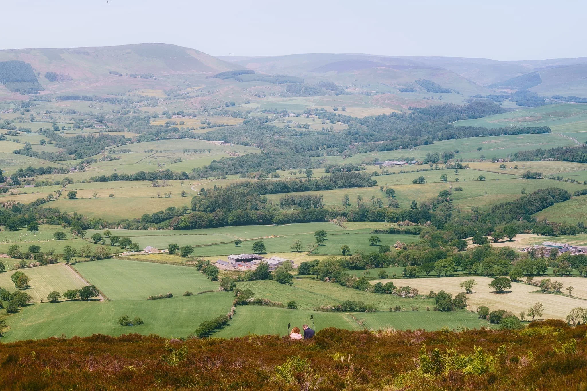
Across the rushes, grass, and valley, the nose of Totridge Fell (496 m/1,627 ft) on the southern edge of the Forest of Bowland becomes apparent.
As we level out near the summit Fie does her best meerkat impression, scoping out the view of the Ribble Valley.
Looking back west along the drystone wall. The clear atmosphere means we can easily pick out the city of Preston, and also Blackpool Tower 20-odd miles away.
Now equipped with my 70–210mm lens, I spot a composition of three solitary trees over the wall, seemingly standing guard over the Ribble Valley.
The moorland that makes up most of Longridge Fell allows for more minimalist landscape compositions, even in the peak of the summer day.
Looking down the sheer drop from near the summit, I spy a couple resting in the heather and bracken, enjoying the view across the valley towards the Forest of Bowland.
From the summit of Longridge Fell, I line up a composition looking east along the drystone wall and the forest edge.
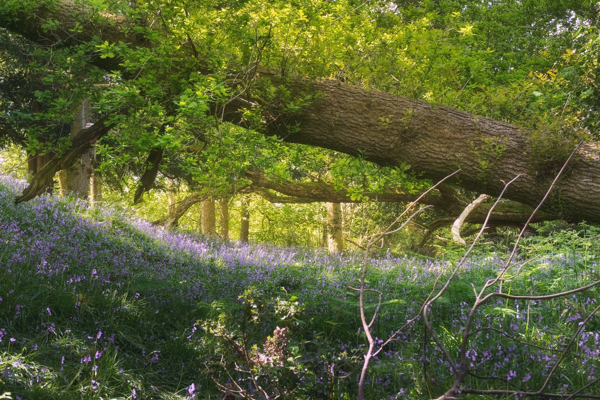
Rather than simply heading back the way we came, we cut through the woodland on top of Longridge Fell. This allowed for some beautiful deep woodland compositions as the summer sun penetrated the trees in atmospheric ways.
One last look back at the summit, across all the ferns and picking out the solitary tree I shot earlier.
Did you enjoy these photos?

Tarn Hows, Lake District, Summer
Summer is upon us.
Summer is upon us.
It’s been a month without any rain, and the temperatures are now consistently in the late teens/early 20s. Rivers and lakes are starting to dry up.
Before things got too crispy and baked, we took a free evening out to Tarn Hows via Tom Gill. Always a good walk, and provides an alternative route to the popular destination that is Tarn Hows. It involves hiking up alongside Tom Gill, occasionally veering off the path to take in a couple of waterfalls. However, they were both almost completely dry.
Tarn Hows was looking incredibly lush and resplendent in its summer finery. One of those evenings that makes you glad to be alive.
All photos taken on my Sony α7ii using my Sony FE 28–70mm f3.5–5.6 OSS zoom lens. RAWs developed in Lightroom for iPad, then edited and finalised in Affinity Photo for iPad.
Tarn Hows, Lake District, Summer 2023 by Ian Cylkowski is licensed under CC BY-NC-SA 4.0![]()
![]()
![]()
![]()
From the upper path around Tarn Hows’ eastern side, my eye catches this fence as a leading line down to the tarn and the Langdale Pikes beyond.
Gorgeous evening light bathes the land and Coniston fells in golden light. In the shade, Herdwick sheep continue their blissful nibbling of the growing grass.
The upper path soon joins the lower one, where we would return back around Tarn Hows. The Grasmere and Fairfield fells peak above the woodland around the tarn.
A panorama, made from 5 vertical images stitched together left to right. I wanted to get all of the dead trees in the frame with the path leading into the distance.
We exited Tarn Hows west via a minor road, and then too came off this road onto a public bridleway, giving us glorious valley views of the Coniston fells.
The road that takes us back home.
Did you enjoy these photos?
Barkbooth Lot, Cumbria, Spring
It was time to capture the last of this year’s bluebells.
It was time to capture the last of this year’s bluebells.
We’re fortunate in Cumbria to have quite a few options when it comes to photographing glorious bluebell displays. On this occasion we decided to revisit a local favourite that also—coincidentally—tends to be quiet: Barkbooth Lot.
Upon arrival it turns out that we were maybe slightly past Peak Bluebell, at least in Barkbooth Lot. Nevertheless, the light was lovely and the woodland is always a joy to gently wander around and find compositions to play with.
All photos taken on my Sony α7ii using my Sony FE 28–70mm f3.5–5.6 OSS zoom and Rokinon 14mm f2.8 ED AS IF UMC prime lenses. RAWs developed in Lightroom for iPad, then edited and finalised in Affinity Photo 2 for iPad.
Barkbooth Lot, Cumbria, Spring by Ian Cylkowski is licensed under CC BY-NC-SA 4.0![]()
![]()
![]()
![]()
Soft woodland light highlights the limestone remnants, moss, and of course the bluebells in this delicious scene.
On the edge of the woods, this dead tree being consumed by vines provides an excellent subject.
The way through the woodlands, across the beck. Like a scene from a timeless fantasy novel.
A patch of bluebells enjoy the shade will unfurling ferns reach up to the morning light.
A trio (tree-oh?) or trees provide a simplified composition, with bluebells surrounding them.
A fallen tree shelters the carpet of bluebells.