Snowdonia & Llyn Peninsula, Wales, Summer, 2016
Here’s another “Retro Reworking” of some older work of mine.
Here’s another “Retro Reworking” of some older work of mine.
Back in July 2016 we spent a nice week around Snowdonia as well as the Llyn Peninsula. We’ve been to Snowdonia quite a few times now, but this was the first time we explored the area in the summer, in addition to some of the Llyn Peninsula.
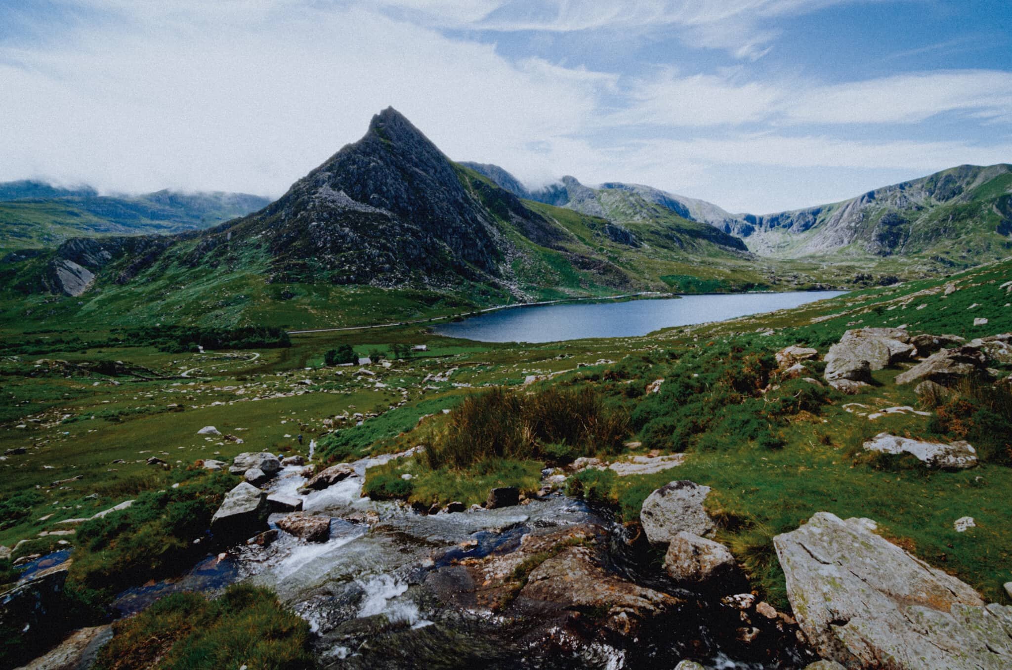
Snowdonia has some incredible mountain scenery, featuring as it does the highest peak in Wales, Snowdon or Yr Wyddfa (1,085 m/3,560 ft). It’s also home to my favourite mountain in all of Wales, Tryfan (917 m/3,010 ft). Every time we visit Snowdonia I try to get the best composition of Tryfan I can. I don’t think I’ve quite nailed it yet.
The Llyn Peninsula juts out into the Irish Sea, southwest of Snowdonia. It’s relative isolation, in part being “disconnected” from the rest of Wales by the mountains of Snowdonia, means the peninsula has high percentage of Welsh-language speakers. It features some incredible beaches and isolated bays and coves to explore.
It was fun to revisit these images with a fresh eye and better skills. I hope you enjoy them.
All photos taken on my camera at the time, which was a Nikon D7000 using both a Tokina 11-16mm f/2.8 and a Nikkor 16-85mm f/3.5-5.6 lens. Developed using RNI’s Kodachrome film profiles.
This is Llyn Padarn, one of the largest natural lakes in Wales, measuring around 2-miles long. From its shore near the Padarn Country Park, one can get an excellent view down the lake towards the Yr Wyddfa and Glyder Fawr mountain ranges.
A slightly different angle of this lone tree, utilising a vertical composition to both the whole of the tree and its reflection in frame. The light was gorgeous on this day, and so calm that the lake was completely reflective.
Zooming in for a tighter composition of the Llanberis Pass, which bisects the Yr Wyddfa and Glyder Fawr mountain ranges.
My favourite Welsh mountain: Tryfan. Viewed from the north and northeast it presents itself with an almost shark fin-like profile. A beautiful mountain. A favourite activity of mine is to hike up alongside the Afon Lloer looking for compositions featuring the cascades of the river towards Tryfan.
Had a go at a vertical composition as well.
From near the Padarn Country Park zooming in at the start of the Yr Wyddfa mountain range.
One beautiful evening we drove towards Llyn Nantlle Uchaf, a small lake that my prior research informed me contained wonderful views towards Yr Wyddfa’s western face. As the sun set a temperature inversion blocked the view through the valley. Still a gorgeous scene, though.
Northwest of Snowdonia, across the Menai Strait, is the island of Anglesey, Ynys Môn in Welsh. If you follow along the northwestern coast of Anglesey you eventually cross the bridge onto yet another small island, Holy Island or Ynys Gybi. Right at the northwest tip of Holy Island is South Stack Cliffs Nature Reserve, complete with South Stacks Lighthouse. A haar had rolled in on our arrival, lending a wonderful atmosphere as we scaled down the cliff path.
As you can see, it’s quite the drop! Incredible scenes, though.
Being the geology nerd I am, I kept stopping at different parts of the winding cliff path to capture the wonderful cliffs and colours at South Stacks.
On this day we didn’t cross the bridge onto the tiny island and its lighthouse. Perhaps one day…
We skirted back around Anglesey’s norther coast to hike around any other bays and coves that looked interesting. This area is called Porth Wen, home to the Porth Wen Brick Works, which you can make out in the distant cliffs. Porth Wen translates as “White Bay”. The sea was an immaculate turquoise on this gorgeous day.
On another day we broke away from Snowdonia and Anglesey and ventured west down the Llyn Peninsula. I had spied a composition in my Pinterest research and thankfully found it near the small settlement of Trefor. I couple of gorgeous sea stacks with another sea haar obscuring the peak of Yr Eifl in the distance. Again, incredible water colours.
A slightly different composition, omitting the peak of Yr Eifl to help feature more of the local geology around Trwyn y Tâl.
Down on the shingle beach near Trwyn y Tâl I spy an interesting boulder that I use to build a composition towards Yr Eifl.
Further down the Llyn Peninsula we navigate the increasingly narrow and small country lanes to locate another bookmark location: Porth Iago. Lisabet enjoyed a swim at the bay with its beautiful white sands and clear water. I went up onto the cliffs above the bay scouting for compositions, and found this wild garden of flowers, sea stacks and cliffs. Bonus camper included.
I do enjoy a good craggy coast line.
Honestly I could’ve spent days around here, scouting for compositions and observing the changes of light.
The main reason people come to Porth Iago: a secluded bay with white sands, clear turquoise water, and handy little coves to get changed in.
Two more photos from within Snowdonia. This is the view down the Nant Gwynant valley towards Pen-y-Pass.
There’s a wonderful viewpoint you can stop the car at as you take the road north towards Pen-y-Pass. It gives you expansive views of the Nant Gwynant valley, Gallt y Wenallt (619 m/2,031 ft) and of course Snowdon/Yr Wyddfa itself.

Retro Reworking: Watlowes Dry Valley, Yorkshire Dales, Winter 2017
I’ve only been to the Watlowes Dry Valley once, back in February 2017, but it was an experience I’ll never forget. I need to get back here again.
The Watlowes Dry Valley, once the site of a huge waterfall.
I’ve only been to the Watlowes Dry Valley once, back in February 2017, but it was an experience I’ll never forget. I need to get back here again.
You can find this place in Malhamdale, one of the more popular areas of the Yorkshire Dales National Park. Most people head to Malhamdale to experience the Big 3 of the area: Malham Cove (a curved sheer cliff), Gordale Scar (a deep ravine), and Janet’s Foss (a pretty waterfall). But above and beyond both Goredale Scar and Malham Cove lies the Watlowes Dry Valley, once the site of one of Britain’s largest waterfalls.
This valley was carved out from the glacial overspill of Malham Tarn, tens of thousands of years ago. Over time the ice melted and a raging waterfall formed and shaped the incredible landscape you now see. At some point in the distant past, the outflow from Malham Tarn that ran into Watlowes found a more efficient route, and now drops down into the maze-like limestone caves underneath Watlowes. As a result, Watlowes dried up and what you see now is the result. The area where Malham Beck now drops into the caves underneath the Yorkshire Dales is called—appropriately—Water Sinks, as the beck appears to magically disappear into the ground just a few hundred metres from Malham Tarn.
A took a solo hike around this area back in February 2017. I had earmarked the Watlowes Dry Valley for a hike because I was insanely attracted to the idea of exploring an extinct waterfall. The place did not disappoint.
A vertical composition of the Watlowes Dry Valley, clearly showing the route the old river used to take before it would fall over Malham Cove as Britain’s largest waterfall.
Another vertical composition highlighting some of the limestone glacial erratics you can find on the slopes of the Watlowes Dry Valley.
A rather lovely chunk of crag I framed into this composition whilst I also got some nice side lighting.

Retro Reworking: Brimham Rocks, North Yorkshire, Summer 2017
Brimham Rocks features a wide variety of rock formations crafted into otherworldly and fantastical shapes for thousands of years..
Honestly there are so many named rock formations in Brimham Rocks that I’ve long lost track of which is which. Nevertheless, enjoy this composition and gorgeous light I managed to nab.
Brimham Rocks is one of my most treasured locations in England.
You can find it on Brimham Moor, appropriately, in the Nidderdale Area of Outstanding Beauty, west of the Yorkshire Dales. The area features a wide variety of rock formations crafted into otherworldly and fantastical shapes for thousands of years.
The original rock here was laid down about 300+ million years ago, but much of the carving of these rocks occurred within the last 100,000 years. They bear beautifully poetic names, such as The Druid’s Idol, Lover’s Leap, The Wishing Stone, The Anvil, and lots more.
I shot these photographs in the late summer of 2017, when we were housesitting a friend’s place near Harrogate. Back then I was shooting on a Sigma dp0 Quattro with a built-in 14mm f/4.0 lens.
I hope you enjoy this short series of weird rocks.
This formation might be called The Baboon’s Head, but I couldn’t be certain.
The formation on the right could be called The Smartie Tube… maybe. One of the nice things about photographing the moors of Yorkshire in late summer is all the brilliant pink and purple heather everywhere.
There’s a few reasons why this composition captivated me. Firstly, all the gorgeous heather. Secondly, I like the way rocks all seem to be pointing towards each other.
I’m fairly sure the formations centre and left are called The Wishing Stone and Pulpit.
Honestly I could spend years hovering around Brimham Rocks with my camera.

Retro Reworking: Cove, Scottish Borders, Autumn 2017
With a better eye, and better tools, I’ve revisited my photographs from our time in Cove and the coast of the Scottish Borders.
Cove Harbour from the cliffs above. The geology of the Scottish Borders coast is absolutely fascinating to me. At Cove, there’s a band of Carboniferous limestone and sandstone ridges that bend towards the north. This is due to a downthrust of the Cove fault about ½ mi southeast.
It’s something of a tradition for me and Lisabet to spend a couple of weeks in autumn somewhere in Scotland.
In 2017 we split that fortnight in two: the first week we stayed in the tiny Scottish Borders coastal village of Cove, then drove across Scotland to get the ferry to the Isle of Arran for the second week.
Cove and the surrounding coastline is delightful. The Scottish Borders, especially the coastal area, is often spared the numbers of people who might otherwise head towards Glasgow, Edinburgh, Loch Lomond, and further north.
With a better eye, and better tools, I’ve revisited my photographs from our time in this beautiful area.
I hope you like what you see. I did.
A longer exposure shot at dusk, showing the craggy cliffs and sea stacks of Cove as well as the “finned” ridges below.
A composition that attempts to feature those finned ridges in Cove Harbour. It’s hard to capture their curvature towards the sea unless you’re above them.
North Berwick beach with the tide out, exposing some of the more unusual rocks and boulders that the sea normally hides.
A simple composition featuring this wonderfully triangular boulder, pointing towards Bass Rock in the distance.
The incredible shapes and colour of Seacliff’s coastline. Here I found a groove running diagonally through the twisted rocks, which I used to try to point towards Tantallon Castle in the distance.
More of the incredible geology around Seacliff, with the ever-present shape of Bass Rock slightly obscured by the haze in the distance.
Slightly separated from the coastline of Seacliff is a rocky outcrop called The Gegan. I intensely scanned its lower slopes, working all its various shapes and forms for compositions.
Seacliff beach, its cliff to the left and the rocky outcrop known as The Gegan in the middle. In the distance, Bass Rock, an ancient volcanic plug made of tough igneous rock that’s survived everything the Firth of Forth has thrown at it.
Further southeast along Seacliff’s beach you can find more igneous intrusions and weird rock formations to play with.
Probably my favourite formations I found on the Seacliff beach.
St. Abbs coast on a seriously foggy day.
It was nice to experience a thick harr around the St. Abbs coast, gave me an opportunity to play with more minimalistic compositions.
Up on the cliffs above Pease Bay, looking back to Cove and its harbour, trying to document the unusual geology of the area.
I was captivated by the vivid red hues of Pease Bay’s sandstone cliffs. This composition is essentially 75% cliff, with just a bit of beach and sea to provide context.
A different section of Pease Bay’s western red cliffs.
I loved the contrast of the vivid red sandstone around Pease Bay against the dusky blue tones of the water. This was a longer exposure to capture that water motion as the tide came in.

Retro Reworking: Mull of Galloway, Scotland, Winter 2018
Welcome to Retro Reworking, otherwise known as “the country’s on lockdown due to a global pandemic so I have a lot more time on my hands also I’m better at editing nowadays”.
Killantringan Lighthouse, north of Portpatrick. Its name comes from the Scottish Gaelic Cill shaint Ringain, meaning “St. Ringan's chapel”. The lighthouse came into life at the start of the 20th century, and was automated in 1988.
Welcome to Retro Reworking, otherwise known as “the country’s on lockdown due to a global pandemic so I have a lot more time on my hands also I’m better at editing nowadays”.
Back in the tail end of winter 2018 Lisabet and I took a short break to the Rhins of Galloway. This is a long north-south peninsula that ends in the south at the Mull of Galloway, the southernmost tip of Scotland. We’d never been here before; our closest venture would’ve been Galloway Forest Park, 30-odd miles east inland.
Despite hiking in winter we were treated to clear blue skies and endless views. We spent most of our time scanning the western coast of the peninsula, ducking in and out of various bays, and hiking along the tops of cliffs. The Mull of Galloway, in particular, provided epic views from its cliffs.
All photographs shot with my camera at the time, which was a Sigma dp0 Quattro with a built-in 14mm f/4.0 lens. ND grads and polarisers were used in-field to balance exposures. Editing and colour grading done manually myself.
Port Mora, one of the numerous little bays one can explore when hiking north from Portpatrick towards Killantringan Bay.
The sweeping views towards the sheer cliffs of the Mull of Galloway. I primarily shot this photograph because I liked the way the ripples in the grass served as repeating leading lines towards the cliffs. Yes, it was bloody windy.
The sheer cliffs of the Mull of Galloway. This was shot from the top of Lythe Mead towards McTaggart’s Rock. I recall seeing a fox corpse further down the cliff here; probably lost a chase against the resident sheep population.
Getting amongst the craggy rocks and sea stacks of Port Logan Bay, looking towards the Mull of Logan.