Holy Island/Ynys Gybi, Anglesey, North Wales, Spring
After getting some delicious mountain action, it was time to head back to the coast.
After getting some delicious mountain action, it was time to head back to the coast.
Anglesey is the largest island in Wales, and the 7th largest in Britain, separated from the North Wales by the narrow Menai Strait.
If you travel across the island all the way to its northwestern tip, you can cross the Cymyran Strait onto a much smaller island called Ynys Gybi, or “Holy Island” in English.
Ynys Gybi features a rocky coastline full of cliffs and rises to 220m/722ft at Holyhead Mountain. Much like Inception, there are an additional two islands off Ynys Gybi: North Stack and South Stack.
Our hiking for the day involved checking out Rhoscolyn Headland, then onwards to revisit the epic South Stack and its lighthouse.
The day was full of low cloud and a dramatic mood.
Photos taken on my Sony a7ii using my Vivitar “Series 1” 28–105mm f2.8–3.8 zoom lens. RAWs developed in Lightroom for iPad, then edited and finalised in Affinity Photo 2 for iPad.
Holy Island/Ynys Gybi, Anglesey, North Wales, Spring by Ian Cylkowski is licensed under CC BY-NC-SA 4.0![]()
![]()
![]()
![]()
Unbeknown to us, Rhoscolyn Head is world-renowned for its fascinating geology. As an amateur “rock nerd” myself, I was delighted with what I found. Here, I found a cliff edge covered in wildflowers, looming over Porth Gwalch.
Fascinating shards of rock like plates of armour line this cliff as a strand of light escapes the thick cloud cover.
Rhoscolyn Head is known for its exposures of the South Stack formation of rocks. These are Cambro-Ordovician metasedimentary rocks, which demonstrate unusual foldings at certain places, such as here.
The day was moody, thick with cloud and moisture, and this added to the dramatic scenes we explored at Rhoscolyn Head.
A resident of Ynys Gybi we did not expect to see! Goats.
Rhoscolyn Head is also known for two sea arches that have been carved out of the cliffs over the course of millennia. After sighting this one from above, we scrambled down the cliff side for a closer look. This is Bwa Gwyn, “the white arch”.
Further along the headland we find the vast gaping maw of Bwa Du, “the black arch”. In the far distances, on the left, is Holyhead Mountain, the highest point on Ynys Gybi at a gentle (220 m/720 ft)
The other side of Bwa Du, with the sun desperately trying to break through the dark cloud cover.
At Gromlech, this lovely little cottage enjoys extensive views across the Irish Sea and onto these folded metasedimentary rocks below. Pure drama.
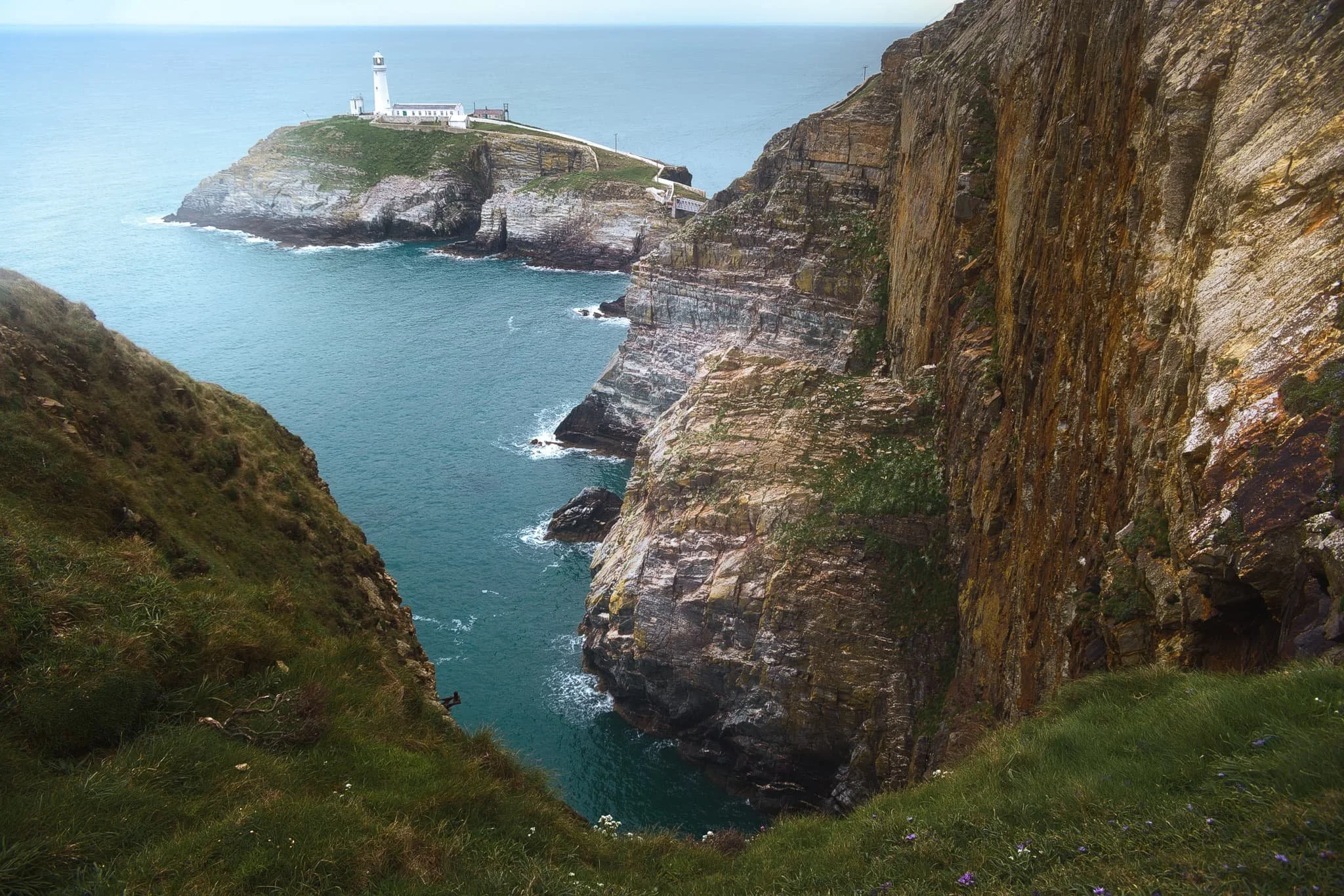
After circumambulating around Rhoscolyn Headland, we drove further up the coastline of Ynys Gybi to revisit a favourite of ours: South Stack. This is a tiny rocky island just off the cliffs of Ynys Gybi, and is home to a picturesque lighthouse. Access is via steep and winding steps that navigate down the sheer cliff face. Every now and then, you get incredible views across the cliffs as you head down the steps.
South Stack lighthouse, shot from higher up the steps. The lighthouse was constructed in 1809 and finally automated in 1983. To begin with, the sole means to traverse to the island was via a basket hung from a hemp rope. Subsequently, in 1828 an iron suspension bridge was constructed, which was then replaced in 1964 by a steel cable truss bridge. Nevertheless, in 1983 it became necessary to close the bridge to the public due to safety issues. Finally, after an aluminium bridge was built, the lighthouse was reopened for public access in 1997. At present, it has become a favoured tourist attraction, drawing many thousands of visitors annually.
Further south from the lighthouse, one can take the path from the RSPCB building down the cliff to Ellin’s Tower, then enjoy a wander along the cliff tops there. A sheer from near Ellin’s Tower gave me this dramatic composition looking back at South Stack and its lighthouse.
Elin’s Tower and, further, South Stack Lighthouse in the distance, with gorse (Ulex europaeus) flowering everywhere. Unusually, gorse in the spring has the strong scent of coconut. Elin's Tower is a Victorian stone tower. This castellated architectural extravagance, initially employed as a summer residence, was constructed between 1820 and 1850 for the prominent Stanley family of Penrhos. It derives its name from Elin (anglicised as "Ellen"), the Welsh spouse of the 19th-century statesman William Owen Stanley.
Did you enjoy these photos?
Snowdonia & Llyn Peninsula, Wales, Summer, 2016
Here’s another “Retro Reworking” of some older work of mine.
Here’s another “Retro Reworking” of some older work of mine.
Back in July 2016 we spent a nice week around Snowdonia as well as the Llyn Peninsula. We’ve been to Snowdonia quite a few times now, but this was the first time we explored the area in the summer, in addition to some of the Llyn Peninsula.
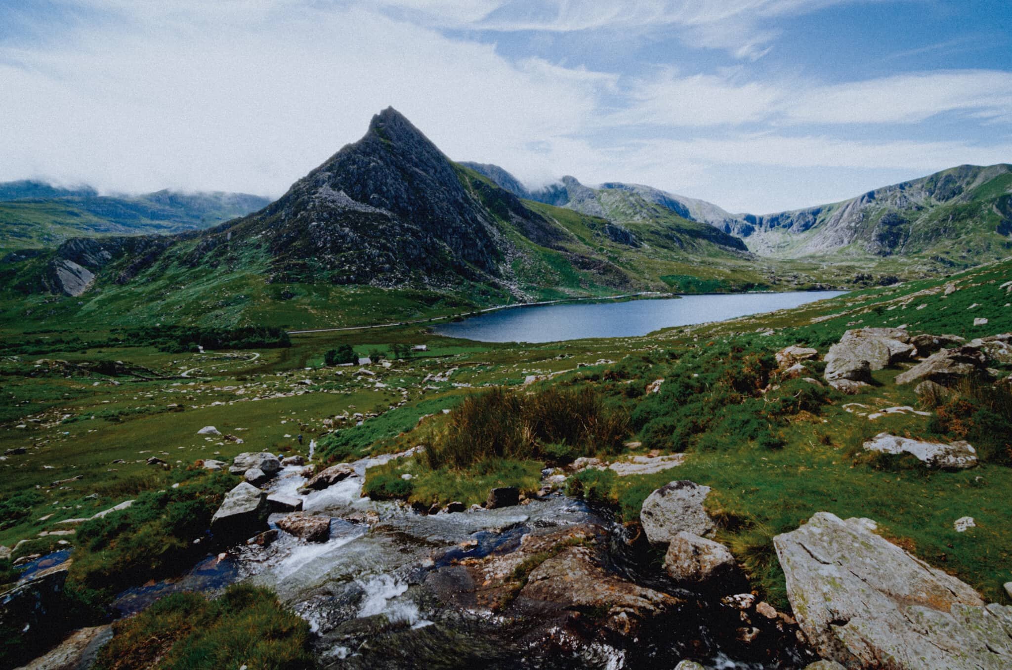
Snowdonia has some incredible mountain scenery, featuring as it does the highest peak in Wales, Snowdon or Yr Wyddfa (1,085 m/3,560 ft). It’s also home to my favourite mountain in all of Wales, Tryfan (917 m/3,010 ft). Every time we visit Snowdonia I try to get the best composition of Tryfan I can. I don’t think I’ve quite nailed it yet.
The Llyn Peninsula juts out into the Irish Sea, southwest of Snowdonia. It’s relative isolation, in part being “disconnected” from the rest of Wales by the mountains of Snowdonia, means the peninsula has high percentage of Welsh-language speakers. It features some incredible beaches and isolated bays and coves to explore.
It was fun to revisit these images with a fresh eye and better skills. I hope you enjoy them.
All photos taken on my camera at the time, which was a Nikon D7000 using both a Tokina 11-16mm f/2.8 and a Nikkor 16-85mm f/3.5-5.6 lens. Developed using RNI’s Kodachrome film profiles.
This is Llyn Padarn, one of the largest natural lakes in Wales, measuring around 2-miles long. From its shore near the Padarn Country Park, one can get an excellent view down the lake towards the Yr Wyddfa and Glyder Fawr mountain ranges.
A slightly different angle of this lone tree, utilising a vertical composition to both the whole of the tree and its reflection in frame. The light was gorgeous on this day, and so calm that the lake was completely reflective.
Zooming in for a tighter composition of the Llanberis Pass, which bisects the Yr Wyddfa and Glyder Fawr mountain ranges.
My favourite Welsh mountain: Tryfan. Viewed from the north and northeast it presents itself with an almost shark fin-like profile. A beautiful mountain. A favourite activity of mine is to hike up alongside the Afon Lloer looking for compositions featuring the cascades of the river towards Tryfan.
Had a go at a vertical composition as well.
From near the Padarn Country Park zooming in at the start of the Yr Wyddfa mountain range.
One beautiful evening we drove towards Llyn Nantlle Uchaf, a small lake that my prior research informed me contained wonderful views towards Yr Wyddfa’s western face. As the sun set a temperature inversion blocked the view through the valley. Still a gorgeous scene, though.
Northwest of Snowdonia, across the Menai Strait, is the island of Anglesey, Ynys Môn in Welsh. If you follow along the northwestern coast of Anglesey you eventually cross the bridge onto yet another small island, Holy Island or Ynys Gybi. Right at the northwest tip of Holy Island is South Stack Cliffs Nature Reserve, complete with South Stacks Lighthouse. A haar had rolled in on our arrival, lending a wonderful atmosphere as we scaled down the cliff path.
As you can see, it’s quite the drop! Incredible scenes, though.
Being the geology nerd I am, I kept stopping at different parts of the winding cliff path to capture the wonderful cliffs and colours at South Stacks.
On this day we didn’t cross the bridge onto the tiny island and its lighthouse. Perhaps one day…
We skirted back around Anglesey’s norther coast to hike around any other bays and coves that looked interesting. This area is called Porth Wen, home to the Porth Wen Brick Works, which you can make out in the distant cliffs. Porth Wen translates as “White Bay”. The sea was an immaculate turquoise on this gorgeous day.
On another day we broke away from Snowdonia and Anglesey and ventured west down the Llyn Peninsula. I had spied a composition in my Pinterest research and thankfully found it near the small settlement of Trefor. I couple of gorgeous sea stacks with another sea haar obscuring the peak of Yr Eifl in the distance. Again, incredible water colours.
A slightly different composition, omitting the peak of Yr Eifl to help feature more of the local geology around Trwyn y Tâl.
Down on the shingle beach near Trwyn y Tâl I spy an interesting boulder that I use to build a composition towards Yr Eifl.
Further down the Llyn Peninsula we navigate the increasingly narrow and small country lanes to locate another bookmark location: Porth Iago. Lisabet enjoyed a swim at the bay with its beautiful white sands and clear water. I went up onto the cliffs above the bay scouting for compositions, and found this wild garden of flowers, sea stacks and cliffs. Bonus camper included.
I do enjoy a good craggy coast line.
Honestly I could’ve spent days around here, scouting for compositions and observing the changes of light.
The main reason people come to Porth Iago: a secluded bay with white sands, clear turquoise water, and handy little coves to get changed in.
Two more photos from within Snowdonia. This is the view down the Nant Gwynant valley towards Pen-y-Pass.
There’s a wonderful viewpoint you can stop the car at as you take the road north towards Pen-y-Pass. It gives you expansive views of the Nant Gwynant valley, Gallt y Wenallt (619 m/2,031 ft) and of course Snowdon/Yr Wyddfa itself.
The Island of Colourful Rocks
Ynys Llanddwyn, the spit of craggy land off Newborough beach in Anglesey, is a botanist’s dream. Not only is the island covered in all sorts of wild flowers, but the exposed crags are drenched in a variety of lichen and moss that create these wonderful tapestries of colour.
Lisabet and I clambered down from the main headland of the island to get a closer look at some of the fascinating colours and plant life on these crags. I shot this composition of one particular crag, looking towards Tŵr Mawr lighthouse and the ruins St Dwynwen’s Church.
Camera: Sigma dp0 Quattro
Lens: built-in 14mm f/4.0
ISO: 100
Aperture: f/16
Shutter speed: 1⁄100s
Software: Sigma Photo Pro, Nik Collection, Affinity Photo