
Walltown Crags, Northumberland, Autumn
There’s so much history in the UK that it can sometimes be hard to separate the work of man from nature.
There’s so much in history in the UK that it can sometimes be hard to separate the work of man from nature.
With a beautiful autumnal weekend on the horizon, Lisabet and I set out to meet up with my Dad for a hike somewhere new: Walltown Country Park in Northumberland.
Two things piqued our interest in this place. Firstly, there’s a great section of Hadrian’s Wall to explore here. And secondly, an art sculpture—known as APERTURA—was set up near the wall as part of celebrating 1,900 years since Hadrian’s Wall was built. Isn’t that astounding?
We couldn’t have asked for better conditions. The day was bright, but not harsh; crisp, but not cold; colourful, but not garish. The staff and volunteers at Walltown Country Park couldn’t have been more helpful and friendly, and exploring this section of Hadrian’s Wall and its turrets was absolutely fascinating.
All photos shot on my Fujifilm X-T2 using my Vivitar “Series 1” 28–105mm f2.8–3.8 zoom and Laowa 9mm f2.8 ultra-wide prime lenses. RAWs converted in Capture One for iPad, developed in RNI Films, and finished in Affinity Photo for iPad.
Walltown Crags, Northumberland, Autumn by Ian Cylkowski is licensed under CC BY-NC-SA 4.0![]()
![]()
![]()
![]()
The approach to APERTURA. A striking sight. It’s shape was designed to mimic the geography of the local area, an insight I was keen to demonstrate in this photo.
With my 9mm ultra-wide equipped I was able to capture the entire installation and use the distortion effects of an ultra-wide angle lens to emphasise the shape.
I enjoyed juxtaposing the tip of APERTURA with the afternoon sun, emphasised by setting my lens at f22 to turn the sun into a star.
APERTURA features 1,900 copper chimes of different sizes (to reflect the 1,900 years of Hadrian’s Wall), which all clang together in the wind, creating a fascinating sonic experience akin to church bells ringing.
Another composition presented itself to me, where I was able to frame Walltown Crags underneath the art installation and its imposing stature.
Whilst prowling around the art installation, enjoying its tones and construction, I noticed the moon was bright in the sky. I re-equipped my Vivitar and zoomed in tight to make the installation “point” towards the moon.
From this angle APERTURA almost looks like a spaceship, or perhaps even a B-2 Spirit Stealth Bomber plane.
We rounded back on ourselves, this time taking the longer path towards Walltown Crags, pictured here high above the pond. Walltown Country Park was formerly a quarry until 1976, and has since been allowed to be reclaimed by nature.
APERTURA, in context of the landscape. It is situated on a small ridge where part of Hadrian’s Wall is now missing.
On the path heading up to the top of the crags, Lisabet and I spotted this lovely simple composition of two trees framing a smaller one in the distance. Nothing fancy, but pleasing nonetheless.
Near the top of Walltown Crags the scale of APERTURA and the landscape becomes more apparent.
Made it to Hadrian’s Wall, now 1,900-years old. That mean the wall’s construction began in 122 AD. Crazy.
Emperor Hadrian commanded a wall to be built across Roman Britain, ostensibly to keep “northern barbarians” out. However, it also served as a way of keeping people in Roman Britain, and controlling trade across the border.
The wall ran from Wallsend on the River Tyne in the Northeast of England to Bowness-on-Solway in Northwestern Cumbria, a distance of 80 Roman miles, or 73 modern miles. Large sections of the wall survive, particularly in hillier areas such as here at Walltown Crags and more famously at Housesteads Fort.
The Romans made use of the local geography when constructing the wall. Large sections of it in Northumberland are built on top of various protruding crags made from hard volcanic dolerite rock. This would’ve gave the Romans a panoramic advantage when trying to spot invasions in the distance.
Of course, the local sheep are oblivious to the historical human significance of the area.
The Walltown Crags are volcanic in origin, made from hard dolerite and known as the Whin Sill. It’s exactly the same rock and protrusion you see at High Cup Nick, High Force, Low Force, and Cauldron Spout, and even as far as the Farne Islands in the North Sea. Geology North has a good map of where in North England the Whin Sill has surfaced above ground to create incredible landscapes.
Looking back at our progress across the top of Walltown Crags, tracking the route where sections of Hadrian’s Wall would’ve been. Unfortunately, even in these hillier parts of the wall, sections are missing where they’ve probably been dismantled for building material over the centuries by farmers and/or landowners.
Our destination: two protruding crags where—according to the OS map—one could find the remnants of Turret 44B and Turret 44A.
A pleasing Northern English scene, featuring trees growing from a solitary crag with cows grazing peacefully below.
Looking back at our progress from Turret 44B. It’s theorised that towering turrets were built along the wall every third of a mile, given the wall structure.
My Dad below, taking in the history of the area, as I clamber up the crag to soak in the extensive views.
Honestly, we could’ve happily carried on the trail to see even more of the wall. Alas, parking is expensive and we were due back. Definitely more to check out next time!
Did you like these photos?
Morecambe & Heysham, Lancashire, Summer
And now for something a little different.
And now for something a little different.
Morecambe’s a good place to visit, especially if you like long walks beside the seaside. It enjoys vast panoramic views across the bay towards Silverdale and Arnside, the Furness Peninsula, and the Lake District fells beyond. You can’t help but take photos of the views before you.
Just a wee bit south down the coast from Morecambe is a small coastal town with a lot of history: Heysham.
Today we did a walk between the two.
Heysham is an ancient place. The main focus of historical human inhabitants is Chapel Hill, a small headland above the bay and Heysham itself. It’s suspected that there’s been human activity here for 12,000 years. Heysham is also only one of three sites in Britain and Ireland that contains pre-Roman labyrinth carving.
On Chapel Hill one can find the ruins of St. Patrick’s Chapel, probably constructed in the 6th of 7th century CE. Next to the chapel is a group of six stone-hewn graves, made around the 11th century. The grounds of St. Peter’s church contains lots of Saxon and Viking artefacts, including a Viking hogback stone that’s on display in the church, making the stone around 1,000–1,200 years old.
It’s an ancient place, and you can feel it around you when you’re on Chapel Hill.
All photos taken on my Fujifilm X-T2 using my Vivitar “Series 1” 28–105mm f/2.8–3.8 and Laowa 9mm f/2.8 lenses. Converted in Capture One for iPad, developed in RNI Films, and finished in Affinity Photo.
Morecambe & Heysham, Lancashire, Summer by Ian Cylkowski is licensed under CC BY-NC-SA 4.0![]()
![]()
![]()
![]()
The security fencing surrounding the site of the former “Frontierland” theme park has now been beautifully decorated with murals from local artists.
This one’s my favourite.
Across Morecambe Bay the tide was on its way out. Two people stroll along the sands seemingly all alone, with the backdrop of the Lake District fells in the distance.
The sail-like structure is called the Hook Beacon, part of a series of sculptures created for the redeveloped West End Gardens along Morecambe Promenade.
Families bravely navigate the sands of Morecambe Bay with the Furness peninsula in the distance.
It was a beautiful day to be out and about in Morecambe.
People from all walks of life were out on the Promenade; running, walking, cycling, skating, and more.
A gentle moment between father and son I felt honoured to have captured.
On a day like this, Morecambe Bay is Big Sky territory.
I love that the town is allowing creatives to brighten up and revitalise the seafront.
On the path towards Heysham we passed some common land where various horses and ponies were contently grazing.
I don’t know if these were Shetland Ponies, but they were cute and inquisitive.
This child was delighted to feed the ponies.
Our destination, the old part of Heysham with Chapel Hill above it.
We took a moment to wander the grounds of St. Peter’s Church in Heysham. Not a bad final resting place, eh?
The small St. Peter’s Church. Records show that an Anglo-Saxon church was present here in 1080 CE, and some parts of it remain in this present-day church.
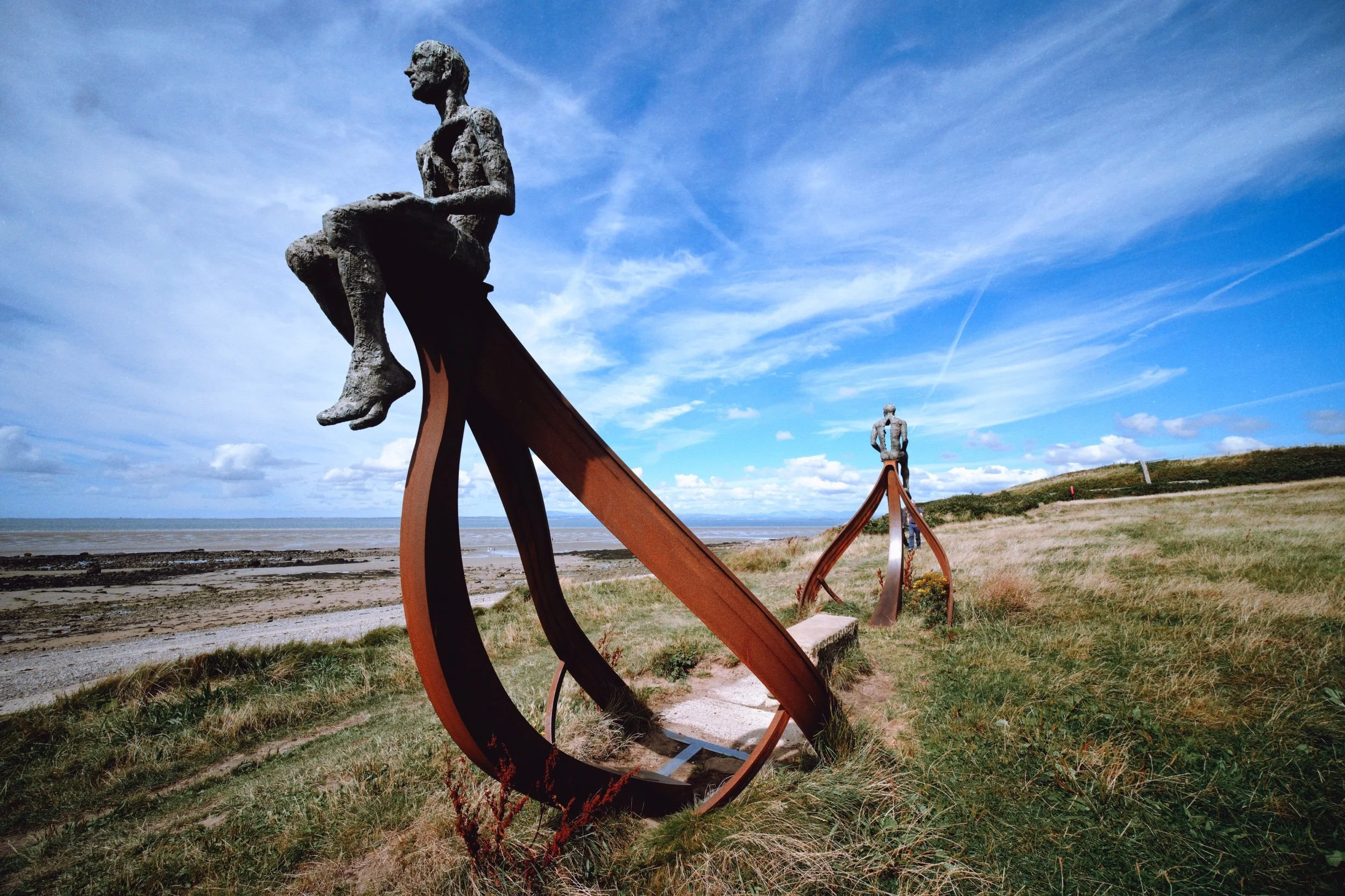
Approaching our ultimate destination for the day. This is “Ship” by Anna Gillespie, with Heysham Nuclear Power Station framed in between.
I whipped out my 9mm ultra wide lens for some interesting compositions of this fantastic sculpture.
I can’t do better than Ms. Gillespie’s words, so here they are: “Symbolically positioned on the boundary between land and sea, benefitting from dramatic backdrops of the tides, horizon and stunning coastal sunsets, the outline of a ship's hull is mounted with two opposing figures at each end, one facing 'the new' of Heysham Nuclear Power Station and the other facing 'the old' of the ancient monument of St Patrick's Chapel.”
I think it’s absolutely brilliant.
Heading back north towards Morecambe, the path clambers over Heysham Head. I paused for some compositions of the rock formations.
Endless views.
We followed the trail alongside Heysham Head towards Chapel Hill and the ruins of St. Patrick’s Chapel.
Most of the south wall, east gable wall, and eastern part of the north wall are still present to this day. Despite the name the chapel was probably built 300 years after the death of St. Patrick.
Next to the ruins are these stone-hewn tombs, probably Viking in origin. They date before the Norman Conquest of 1066 CE.
My lovely Lisabet, admiring the views and soaking in the ancient presence of this mystical place.
The way back to Morecambe. What a lovely day.
Did you like these photos?
Coldstones Cut & Almscliffe Crag, North Yorkshire, Spring
Yorkshire’s a beautiful county, isn’t it?
Yorkshire's a beautiful county, isn't it?
Living in Kendal as we do, we enjoy closer access to the Yorkshire Dales, an area in North Yorkshire we love dearly. But there's plenty more outside of the Dales.
Pateley Bridge, where we stayed at recently, is situated in the Nidderdale AONB, which lies outside of the Yorkshire Dales National Park. It's a stunning area in its own right. A 10-minute drive west of Pateley Bridge takes you up onto the moorland where can visit the incredible Coldstones Cut construction.
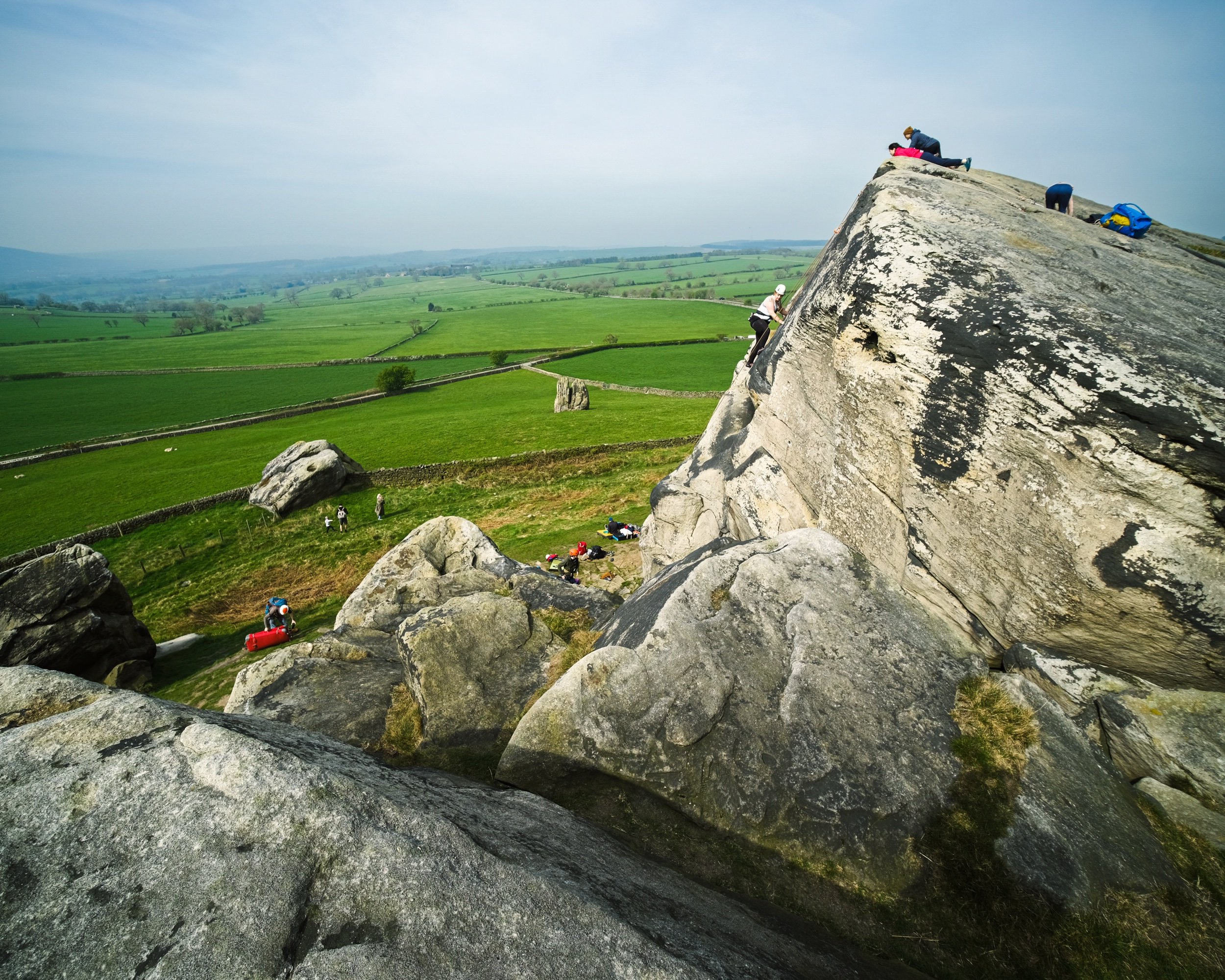
Further south of Pateley Bridge, near North Rigton, one can find the impressive Almscliffe Crag, a cap of millstone crags and rock formations sitting on top of a small hill. It's popular with rock climbers and boulderers, not to mention a walker's paradise.
On this particular occasion, we visited both areas on a beautiful yet hazy spring day.
All photos shot on my Fujifilm X-T2 using my three prime lenses: a Fujinon 23mm f/2.0, a Laowa 9mm f/2.8, and an adapted Pentax SMC 55mm f/2.0. Images made 80% in-camera using the Astia film simulation, then finished off in Lightroom and Affinity Photo.
Coldstones Cut
The entrance to Coldstones Cut, 400m above sea level.
Looking back down the "street" entrance of Coldstones Cut, the sun beaming right at us. Lisabet decided to go full Instagram Mode.
A 5-shot panorama of the view from one of the many view areas at Coldstones Cut. The construction overlooks the imposing Coldstones Quarry, the last remaining quarry in the area that was once dominated by a multitude of limestone quarries. It's estimated the quarry has 15-20 years of productivity left, after which it will be left to green over and return to nature.
Beneath Coldstones Cut and its quarry one can find the ruins of Toft Gate lime kiln. Limestone dug from the hill above was heated by fires in the kiln to produce quicklime for local agriculture through the 19th Century.
Almscliffe Crag
After exploring Coldstones Cut and appreciating the art and views, we ventured south near North Rigton. Here one can enjoy quick access to the imposing Almscliffe Crag.
Though not that busy, and certainly not in Lake District terms, there were still plenty of people milling around the crags. Mostly rock climbers.
Crags and rock formations like these inspire me to whip out my 9mm ultra-wide lens for some unusual and fantastical compositions.
As the crag is made of harder millstone rock, the hill it sits on is isolated from the rest of the land. This helps offer extensive and panoramic views, no matter where on the crags you are.
I appreciated the grit and determination of these rock climbers. I certainly couldn't do it.
Leading lines, curves, and textures ahoy. My happy place.
Lisabet and I clambered around the various nooks and crannies in between the crags, finding interesting views and compositions to photo.
I enjoy getting into precarious situations for those "hard to find" compositions and views.
I shot this primarily for the way the rocks seem to point at the road, which then zigzags off into the distance.
Directly beneath the crag that marks the highest point of the hill.

On the top, the crags have been smoothed out by millennia of erosion from wind and rain.
People cherishing the experience and moment in their own way from the top of Almscliffe Crag.
It's all starting to look beautifully verdant.
A couple and their pooch enjoy the summit views that stretch out for miles and miles.