
Kirkby Lonsdale, Cumbria, Spring
Cumbria’s got super cold again after last weekend’s bizarre heatwave.
Cumbria’s got super cold again after last weekend’s bizarre heatwave.
Following the weekend’s temperatures pushing 20ºC, Monday onwards saw conditions plunge back down to freezing point with fresh snow falling on the fells. Thankfully, as the week progressed, the atmosphere cleared up and blue skies have been a regular feature, but temperatures are still barely reaching 10ºC.
Yesterday, after a morning of Life Admin, Lisabet had a long-awaited hair appointment at the newly established Wilderness Hair Lune Valley at Kirkby Lonsdale. Whilst she was enjoying having her glorious curls revived, I enjoy the glorious spring day in this ancient and bonny town.
All photos shot on my Fujifilm X-T2 using my three prime lenses: a Fujinon 23mm f/2.0, a Laowa 9mm f/2.8, and an adapted Pentax SMC 55mm f/2.0. All images made 80% in-camera using the standard Provia profile, finalised afterwards in Affinity Photo on my iPad.
The site of the old Swine Market before you head down Mill Brow.
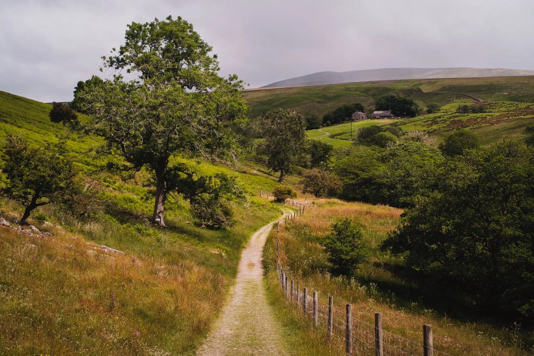
Heading down Mill Brow, an almost timeless scene.

The Old Manor House, largely built in the 1700s, though some surviving parts of the building are even older.
From the bottom of Mill Brow I followed the River Lune all the way to Devil’s Bridge. Here, limestone formations are abundant and I had fun arranging compositions involving these rocks and the formidable Devil’s Bridge.
On top of Devil’s Bridge a clear is offered to Stanley Bridge, which carries the A65 over the River Lune. Below, some folk play around the limestone formations alongside the river.
People checking out the views from Devil’s Bridge and helpfully providing my photo a sense of scale.
Always a good view from the top of Devil’s Bridge.
Heading back into town, I can never resist a shot of this majestic house covered in ivy.
On Market Square in the middle of Kirkby Lonsdale sits the former Trustees Savings Bank, built in the middle of the 19th-century. It’s now a private abode.
St. Mary’s Church, one of the oldest buildings in Kirkby Lonsdale. Parts of it date back to Norman times.
And, at this time of year, the cemetery grounds of St. Mary’s are covered in a variety of daffodils.
Just beyond the church is a short path to Ruskin’s View. Described by 19th century art critic, social theorist, painter and poet John Ruskin thus: “I do not know in all my country, still less in France or Italy, a place more naturally divine.”
Zooming in on the Barbondale fells and the heavy clouds looming above.
From Ruskin’s View, I navigated back to the town centre and up to nab one of my favourite views in all of Kirkby Lonsdale: the view down Mitchelgate with Gragareth in the distance.
Barbondale, Yorkshire Dales, Summer
With the summer heat increasing once again, it was time to revisit a favourite of ours: Barbondale.
With the summer heat increasing once again, it was time to revisit a favourite of ours: Barbondale.
The last time we hiked around the area was May last year (2020). One year and a month on, tree felling operations in the area are still very much in action. I wonder why a lot of the woodland in the valley is being cut down and replanted? It is quite sad to see.
We decided to slightly extend our usual walk from Barbon village to the valley clearing by following the trail up the gill between Barbon Low and High Fell. This lands you at Bullpot, home to the Red Rose Cave & Pothole Club. There are a myriad of caves and potholes here that give access to the area’s famous Easegill cave system.
My experience of the hike was unfortunately somewhat marred. As the temperatures are rising again, I decided to go hiking in shorts rather than a pair of trousers. This was a mistake as Barbondale was busy with activity from Deer Flies, a few of which decided to persistently attack my calves for that delicious blood fuel.
Lesson learned: don’t wear shorts when hiking in the summer.
Photos taken on my Fujifilm X-T2 using my Samyang 35mm f/1.2 lens. Images were 80% made in-camera using a “Nostalgic Negative” recipe, with minor edits later in Lightroom and Affinity Photo.
The Churchmouse at Barbon, a lovely little café and cheese shop in Barbon village.
Not bad views if you live in Barbon.
Barbon is proper lovely, and though technically in Cumbria it very much feels like a rural Yorkshire village.
St. Bartholomew’s church. The present structure dates from the early 19th century, located slightly south of an earlier chapel built in the 1600s.
Machinery at rest is now dotted about the area of Barbondale woods. I’m sure there are pertinent reasons to cut down so many trees, but it’s still saddening.
The peak of Barbon Low Fell, set against what remains of Barbondale woods and some summer wildflowers.
The lack of trees in Barbondale has revealed at one thing to me, though: there are a lot of Foxglove (Digitalis purpurea) in the valley.
Steadily making our way towards Barbondale head and its clearing.
The view that greets you once you pop out of what’s left of Barbondale woods. The weather was… interesting. It was warm, but with gusts of alternating cold and hot air, interspersed with gentle sprays of rain from a distant cloud burst. You can see the cloud burst above Crag Hill in the distance.
After stopping for lunch by Barbon Beck, we took the trail up the gill between Barbon Low and High Fell, clearly signposted for Bullpot. The deer flies were ravenous.
The views looking back down to Barbondale started to open up as we climbed higher.
A beam of light scans across Barbondale and its highest fell, Calf Top.
Red Rose Cave & Pothole Club at the top of Bullpot, formerly the home of Bullpot Farm. We could’ve continued the hike around the head of this tiny valley to explore Easegill, but the flies had pissed me off enough so we made our way back to the car.
The top of the trail between Bullpot and Barbondale. Damp, fecund, and full of flies.
A curious Swaledale ewe pauses her meal to ensure I’m not a threat.
The road back to Barbon village. High in Barbondale woods to the right, you can spot Barbon Manor.
Arriving back at Barbon village, complete with relief from getting away from all the flies and guilt for letting them annoy me so much.

Barbondale, Yorkshire Dales, Spring
Barbondale holds a special place in our heart.
Barbondale holds a special place in our heart.
Lisabet spent many a time in her childhood playing in this valley with her family. It’s also the place where Lisabet’s grandfather’s ashes were scattered.
Barbondale gets its name, like a lot of Yorkshire Dales valleys, from the river that runs through it: Barbon Beck. In turn, the beck was named after the family that owned the manor and all the surrounding land. There are two theories where the name “Barbon” comes from:
A corruption of “Barbourne”, a parish in Worcestershire, or;
An old French Huguenot family name.
Unfortunately a lot of the woodland in Barbondale has been cut down and replanted, apparently to contain some sort of fungal infection.
All photos shot on a Fujifilm X-T2 with a 16–50mm f/3.5–5.6 lens using the Classic Chrome film mode.
Rhododendron ponticum, beautiful to look at but unfortunately a rather invasive and overwhelming species. Also apparently toxic to European honeybees.
A hawthorn tree leaning towards the craggy profile of Barbon Low Fell (438 m/1437 ft).
The way to Upper Barbondale, with Crag Hill in the distance (682 m/2,238 ft).
A lone tree with beautifully wispy clouds.
That’s right, another drystone wall means another photo of me tracking its path up the fell.
Upper Barbondale, featuring the precipitous shoulder of Calf Top (610 m/2,000 ft) and the winding road towards Dentdale.
Looking back along the road to Crag Hill and Fell House farm underneath.