
Sleat Peninsula, Isle of Skye, Scotland, Spring
Skye’s Sleat peninsula often gets overlooked.
Skye’s Sleat peninsula often gets overlooked.
It’s understandable why. When the island contains wonders such as the Cuillins, the Quiraing, the Storr, the Fairy Pools and more, why would you go to the extreme south/south-west of the island?
In my experience, Sleat is where you take photos from, not of. While the peninsula does have some lovely coastline, arguably it’s finest aspect is the views you can get from its southern and northern shores.
Looking south across the Sound of Sleat one can enjoy immense views of the Knoydart mountains, such as Ladhar Bheinn, Meall Buidhe, and Luinne Bheinn.
Over the peninsula onto its northern shores, Sleat harbours beautiful beaches and craggy coastlines, punctuated by bonny little crofting settlements, such as Tarskavaig, Tokavaig, and Ord. These places get unparalleled views across Loch Eishort towards the entire Cuillins range.
My advice: Give yourself a day to explore Sleat. You won’t regret it.
All photos taken on my Sony α7ii using my Rokinon 14mm f2.8 ED AS IF UMC and Pentax SMC 28mm F3.5 prime lenses, and my Vivitar “Series 1” 70–210mm f2.8–4.0 zoom lens. RAWs developed in Lightroom then edited and finalised in Photoshop.
Sleat Peninsula, Isle of Skye, Scotland Spring by Ian Cylkowski is licensed under CC BY-NC-SA 4.0![]()
![]()
![]()
![]()
Just north of Armadale there’s a stretch of coastline known as Bàgh a' Mhuilinn (“Bay of the Mill”). Here, one can play around with incredible rock formations and the Knoydart mountains in the distance.
The geology around Armadale is largely comprised of Lewisian Gneiss, which are some of the oldest rocks on Earth; roughly 3.0–1.7 billion years old! In the distance the main peak in the Knoydart is Ladhar Bheinn (“peak of the hoof”).
From near Armadale you can take the single-track winding road over the Sleat peninsula towards its northern shores. Along the way, though, magnificent views of the Cuillins reveal themselves. We stopped to nab some photos from above Loch Dhùghaill because who can say no to this?!
Arriving at Tarskavaig Bay, Lisabet and I quickly wandered off to explore and photography. I found this fascinating person-high crag on the beach, and clambered within its nooks and crannies looking for compositions. These are Lewisian Gneiss again, but have been squashed and stretched so much that they've become very fine-grained and have lots of cracks. They also have minerals like chlorite and epidote in them.
Away from the massive crag I head towards the more expansive beach, with fantastic clear views towards the Cuillins. I find another otherworldly rock formation and seek to compose along with the winding channels towards the Cuillins.
Moving on from Tarskavaig, we continue up the northern shore of Sleat to Tokavaig. At Tokavaig Bay, one can find the ruins of Dùn Scaich castle, formerly owned by Clan MacDonald of Sleat, a branch of the Clan Donald or MacDonald. With my long zoom lens, I can really compress the distant views, capturing the ruins of the castle as well as the mighty Blàbheinn mountain in the distance.
Dùn Scaich castle sits atop a crag on the Tokavaig coast, given near 360 views of its surroundings. It would’ve once been possible to enter the ruins across the arched footpath, but the floor of it has collapsed. The fortress is alternatively referred to as the "Fortress of Shadows." It is famously associated with the legend of the warrior woman Scáthach, who is said to have resided there, giving the castle its name.
Further long the coastline from the castle ruins are several sheer cliffs that offer unimpeded views across Loch Eishort to the entire Cuillins range. Here, my Lisabet stands perilously close to the edge of one cliff, providing a sense of scale.
The view you can enjoy from Tokavaig’s cliffs. The small trio of islands in the loch are called Eilean Ruairidh, translating as “Isle of the Red King”. There was once a fort here too. From this view, it’s clear to view the geological differences between the Black Cuillins, towards the left, and the Red Cuillins towards the right. The Red being smoother and made of granite, and the Black being more jagged and made of gabbro.
Further along the coastline we arrive at Ord, where one can take the minor road back over the Sleat peninsula to its southern shores. Before we did, we explored the bay here too. At Ord, you can find crags on the beach where old rocks meet some younger rocks called quartzites, and the younger rocks are found underneath the older ones, which is a bit unusual. The quartzites have some cool features, like cross-bedding (patterns in the rock) and folding (where the rock has been bent).
From Ord I once again equipped my 70-210mm zoom lens for some tighter compressed compositions. I lined up the small rocky islands just off the bay to lead towards the Strathaird coastline and Blàbheinn looming above everything.
Did you enjoy these photos?

Sligachan, Isle of Skye, Scotland, Spring
I have returned from my fifth visit to Skye.
I have returned from my fifth visit to Skye.
God damn I love that island so much.
What definitely helps, apart from the fantastic scenery, is that for entire week of our stay the weather and light conditions were fantastic.
All in all, I returned to Cumbria with 200+ RAW files of epicness. Where does one start?
For me, with one of my favourite places on Skye: Sligachan.
Sligachan is a small settlement on Skye’s eastern coast, somewhat halfway between two of Skye’s major population centres: Portree and Broadford. There’s not much at Sligachan apart from a hotel and a couple of houses. What it does offer is some of the finest views of the Black Cuillins and Red Cuillins on Skye.
In particular, there are a number of small rivers that run from the Cuillins towards Loch Sligachan, and the underlying geology has enabled some fantastic waterfalls. You’ve just gotta be prepared for some boggy hiking.
I’ve played around these waterfalls many a time, always seeking the “one” winning photo from this area. On this occasion, I’ve come closer than ever before of capturing that special photo from this magical place.
All photos taken on my Sony α7ii using my Pentax SMC 28mm F3.5 and Rokinon 14mm f2.8 ED AS IF UMC prime lenses. RAW files developed in Lightroom, edited and finalised in Photoshop.
Sligachan, Isle of Skye, Scotland, Spring by Ian Cylkowski is licensed under CC BY-NC-SA 4.0![]()
![]()
![]()
![]()
On our first full day on Skye, we first enjoyed the Scorrybreac circular around Portree. Afterwards, we nipped south to visit Sligachan. Whilst Portree was relatively sunny, conditions at Sligachan were significantly different. Stormy skies and powerful freezing winds made for some awe-inspiring conditions. On this occasion this was the best image I could make on this brief visit, the Red Cuillins topped in snow with storm clouds brewing above.
Returning to Sligachan on another day presented a completely different story, with strong sun bursting through the passing, racing clouds. Our first port of call was getting under the Old Sligachan Bridge for a composition of the Black Cuillins.
Afterwards, we began the hike up alongside one of Sligachan’s many rivers, this one being the Allt Dearg Mòr (“Great Red River”). Numerous waterfalls can be found along the river, this one being one of the bigger ones. My ultra-wide 14mm lens was able to capture not only the entirety of the falls and the snow-capped Black Cuillins, but some of the Red Cuillins too.
Beyond the large waterfall, a wide series of falls presented a beautiful composition involving the Black Cuillins as the clouds sank over the mountains.
Getting closer to the falls as I dared, I faced directly towards the sun and attempted a composition of the falls with one of the Red Cuillins, Marsco (736 m/2,415 ft).
A 3-shot 28mm panorama stack from top to bottom enabled this composition of another waterfall with the snowy Black Cuillins darkening above.
Looking back down the river towards the Red Cuillins saw clearer skies. On the left, the wizard’s hat of a mountain is Glamaig (775 m/2,543 ft), catching the light on its smooth flanks. The other Red Cuillin in the distance is Beinn Dearg Mhòr (731 m/2,398 ft)
Back at the Old Bridge, a classic composition involving the bridge and Glamaig proved impossible to resist. In the late 1800s a Gurkha named Harkabir Tharpa scaled Glamaig, starting and finishing at sea level in the bar of the Sligachan Hotel, in 55 minutes. That’s nuts, especially considering most routes up the mountain involved a steep climb on loose scree.
Did you enjoy these photos?
The Rest of Skye & Beyond, Scotland, Autumn
Happy Boxing Day everyone.
Happy Boxing Day everyone.
One of the nice things about editing these photos from Skye is that I get to revisit this wonderful place all over again. I can send my mind right back to October 2020, place my two feet in the scene, and immerse my visual memory in the whole experience.
That’s also why this post and series of photos saddens me.
These are my last lot of photos from our 2-week trip around Skye.
This post is a sort of mish-mash of photos from various different parts of Skye that we didn’t get an awful lot of time to properly explore. As a result, rather than publishing multiple posts with only 2–3 photos in each, I thought I would combine them all in this Farewell Skye post.
In this post you’ll find photos from the famous Neist Point, with its remarkable cliffs, coastline, and—in our experience—a dramatic storm system; Talisker bay, including its sea stacks, cliffs, waterfalls and mountains; and assorted shots from around the Sleat peninsula, which we managed to nab before constantly getting drenched.
There’s a couple of little extras too, that I hope you’ll like.
Thank you for visiting my website and experiencing my visual memories of Skye with me over the last couple of months.
Here’s to more UK travel if, and when, circumstances allow, in happier times.
Sleat Peninsula
The Sleat peninsula of Skye is arguable one of the least explored places on the island. The peninsula is the southernmost point of Skye and geographically different from much of Skye, which is why it’s often referred to as the “garden of Skye” for its rolling land and rich soil, compared to the rest of the island’s jagged peaks, craggy land, and cliffed coastline. Our first stop on Sleat was Tarskavaig Bay at Gillean Beach. A view across the sea allows you to pick out some of the peaks of the Black Cuillins. The drama in this photo is testament to the stormy conditions we experienced on this peninsula.
My eye quickly round some rather interesting rock formations around Gillean beach. I endeavoured to make some compositions whilst it was vaguely dry enough to shoot. The hill on the left is Sìthean Beag.
Lots of formations of volcanic origin around Gillean Beach.
A hint of the Black Cuillins in the distance as a break in the thick cloud cover allows some dramatic spotlighting.
Moving further north and east around the Sleat Peninsula, we stop off at another small settlement, Tokavaig. Lots of proper Viking names around here. At Tokavaig one can find what’s left of Dùn Scaich castle. This was once a fort belonging to the Clan MacDonald of Sleat, before being wrestled for power many times over the centuries. Clan MacDonald eventually abandoned the castle in the 17th century. It’s named after a mythical figure, “Scáthach the Shadow”, a legendary Scottish warrior woman and martial arts teacher, who trained the hero Cú Chulainn in the arts of combat.
Talisker Bay
Further to the northwest of Skye, beyond the Black Cuillins, is Talisker Bay, a favourite of ours. You may be familiar with the name as one of Scotland’s well-known whiskies is named after it (in fact, Talisker Whisky is made further inland at Carbost).
The northern side of Talisker Bay features sheer cliffs and a delightful waterfall dropping right into the sea. The waterfall is the outflow from a small loch just above the cliffs, Loch an Sgùirr Mhòir.
On the southern side of the Bay is the sea stack known as Talisker Point, here catching some morning light.
This is the path one takes to reach Talisker Bay from further inland. The remarkable knuckly hill is Preshal More (324 m/1,062 ft).
Neist Point
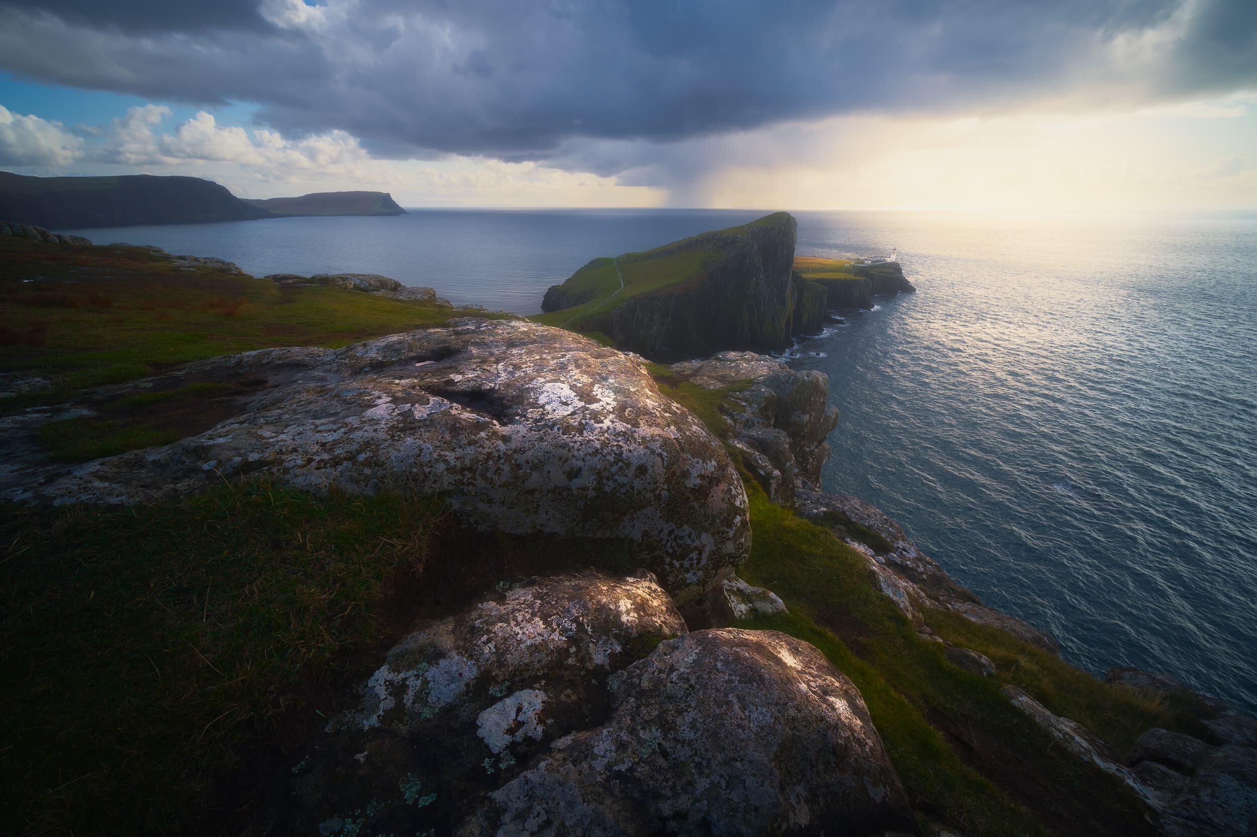
We managed a brief visit to Neist Point during a day spent running away from various wet weather systems. The area is known for its views towards the Neist Point cliffs and its lighthouse, but one shouldn’t ignore the vast cliffs of Waterstein Head, reaching 882 ft high.
With my 9mm ultra-wide Laowa lens I was able to capture this vast panoramic view of Neist Point, its lighthouse, as well as the Ramasaig cliffs. We watched as a weather system approached us from across the sea, absolutely heaving it down into the waters.
Another ultra-wide composition, shot vertically, showing Neist Point’s cliffs and lighthouse, with the storm quickly approaching us.
Bonus
One of our “bookmarks” for October 2020’s Skye holiday was the Falls of Rha. These are a pair of powerful waterfalls located near Uig, north Skye. The falls are found in a wooded glen—relatively rare on Skye—and are almost disappointingly easy to get to. Nevertheless, they are an impressive site.
As we left the Isle of Skye on the final day we hopped back onto mainland Scotland and took a small detour to capture this incredible view. These are the Five Sisters of Kintail, a 5-mile long pointy mountain ridge. They are Sgùrr na Ciste Duibhe (1,027 m/3,369 ft, meaning “Peak of the Black Chest/Coffin”), Sgùrr na Càrnach (1,002 m/3,287 ft, meaning “Peak of the Stony Place”), Sgùrr Fhuaran (1,067 m/3,501 ft, meaning “Peak of wells/fountains”), Sgùrr nan Saighead (929m/3,048 ft), and Sgurr na Moraich (875 m/2,873 ft).

Camasunary, Isle of Skye, Autumn
As well as revisiting old favourites of ours on Skye, we also wanted to check out unfamiliar territory across the island.

As well as revisiting old favourites of ours on Skye, we also wanted to check out unfamiliar territory across the island.
A new, to us, hike we bookmarked was located on the Strathaird peninsula of Skye, perhaps more widely accessed for getting to Elgol. We did revisit Elgol again, but on the way back we stopped at a parking layby near Kirkibost for a hike up and over the Strathaird peninsula towards an isolated little bay called Camasunary.
This hike ended up being the best thing we did on the Isle of Skye.
Camasunary is the Scots form of the Scottish Gaelic Camas Fhionnairigh, which means “Bay of the White Shieling”. This implies that this bay, in times past, was once used as summer grazing for livestock, when transhumance farming was more common.
As we had spent time around Elgol for sunrise, our hike to Camasunary was still early in the morning, which provided us with dazzling displays of light and shadow on some of the most epic scenery we’ve ever seen.
Photos shot on my Fujifilm X-T2 primarily using a Samyang 35mm f/1.2 with occasional backup provided by my Laowa 9mm f/2.8. I used a customised Pro Negative Standard film profile.
We couldn’t have asked for better conditions as we began our hike from the layby at Kirkibost. Here, a long lenticular cloud hovers above Nead an Fhìor-eòin (334 m/1,095 ft).
One of my favourite Skye mountains, Blà Bheinn, is more famously viewed from the shore of Loch Slapin. But from this hike the mountain’s fin-like southern ridge is more prominent, and I managed to snap this shot as the peak caught some morning light.
As we crested the summit of the trail, views of the Black Cuillins started to open up and our excitement levels shot through the roof.
The view of Camasunary Bay from the summit of the trail. Holy moly, what a view! The mountain to the right is Sgurr na Stri (494 m/1,620 ft), definitely one of the smaller peaks on Skye but its position above Loch Coruisk means the view from its summit is perhaps one of the finest in Britain (and one I hope to see myself one day). To the left, catching the morning light, is Gars-bheinn (808 m/2,650 ft).
As we began following the trail down to Camasunary Bay we were faced with the massive southern face of Blà Bheinn (928 m/3,044 ft) high above, glowing gold in the morning sun. We also weren’t the only ones enjoying this hike.
Bright slivers of golden light streak across the various faces of the Black Cuillins. In my head, the Lord Of The Rings theme music plays incessantly.
A particularly strong burst of light breaks through the low clouds as I shot this view across Loch na Creìtheach. The hill on the left is Sgùrr Hain (420 m/1,377 ft) and the crown-like summit in the distance is Sgùrr nan Gillean (966 m/3,170 ft), one of Skye’s most famous peaks. Its name translates from Scottish Gaelic as “peak of the young men”.
We finally arrived at the flat bay of Camasunary. There’s three buildings on the bay; two of them are bothys (one old and disused, another freshly constructed). The building pictured, though, is a private house. I’m not sure if it’s still in use or not; it looked in various states of disrepair. You have to admit, it’s a cracking spot for a house.
This is the old Bothy, located at the western end of Camasunary Bay, close to the beach, with Sgurr na Stri above. In 2014 it was reclaimed by the private owner of the Bay, and a newer bothy was constructed back at the eastern end of the Bay. If you don’t know, a bothy is a basic building or shelter and usually left unlocked, available for anyone to use free of charge. They’re quite common in the mountainous areas of Scotland, but you do find them in places like the Lake District too.
Heading back up the trail, I couldn’t resist one last look back at this stunning view of Camasunary Bay.
As we made our way back to the car at Kirkibost the clouds got angrier and occasional spits of rain signalled the end of our luck with the light and weather this day. However, another burst of light from behind us illuminated this solitary tree, which I lined up with the pyramid peak in the distance that was also catching the light.

Glen Brittle, Isle of Skye, Autumn
Skye has one or two “hotspots” that are vastly more popular for visitors.
Skye has one or two “hotspots” that are perhaps vastly more popular for visitors than other areas around the island. The Storr might be considered one of those hotspots.
Another would be the Fairy Pools of Glen Brittle.
The last time I checked out the Fairy Pools was way back in 2013, when we first explored the Isle of Skye. I was instantly beguiled by the variety of cascades and waterfalls, creating pools of brilliant turquoise as a result of the crystal clear water and reflecting the colours of the rocks.
As you climb up the path alongside, the backdrop is increasingly dominated by the jagged skyline of the Black Cuillins, particularly the peak of Sgùrr an Fheadain (689 m/2,260 ft) and the fissure that runs down it known as Waterpipe Gully.
After capturing all kinds of compositions around the Fairy Pools, noting the light changes as the sun rose above the Black Cuillins, we ventured further down Glen Brittle to check out some of the less-visited cascades and falls. In particular, after a short but steep hike, we were floored to discover a sudden gorge dropping beneath our feet and a huge waterfall falling into it, with the Black Cuillins framed above. An absolutely incredible sight.
All photos shot on my Fujifilm X-T2 with both a Samyang 35mm f/1.2 and a Laowa 9mm f/2.8 lens using a customised Pro Negative Standard film profile.
The shooting started almost immediately after parking up, as we could see the rising sun just starting to peak above Sgùrr an Fheadain, casting beams of light around the mountain. Incredible scenery.
As we hiked further up the path the hill fog started to burn off, revealing some of the tops of the Black Cuillins. This peak in particular is Sgùrr Thuilm (meaning “Rocky peak of the hillock”) and measures 881 m/2,890 ft high.
This is one of the bigger waterfalls of the Fairy Pools. The photo is comprised of 6 landscape frames, shot top to bottom, and merged into a single “bokehrama”.
At this point of the river, known as Allt Coir’ a’ Tairneilear, the bigger waterfalls give away to a myriad of criss-crossing smaller cascades, each creating their own little pools of brilliant turquoise. The rising sun was getting above the Black Cuillins, casting strong golden light on the carved rock forms of the river.
Probably my favourite composition from the whole hike, tracing the winding carved rock through to the falls and the mountains beyond as the sun highlights their forms.
One of the last cascades on the Allt Coir’ a’ Tairneilear before the river flattens out directly underneath Sgùrr an Fheadain. Beautiful golden light picks out the various ridges and shelves of rock around the river.
My lovely Lisabet, on our way back down the valley.
The hills that form the western side of the Glen Brittle valley, catching the post-sunrise light. Right to left: Beinn a’ Bhràghad (459 m/1,505 ft), Beinn Staic (412 m/1,351 ft), and An Cruachan (435 m/1,427 ft).
Taking one last look at Sgùrr an Fheadain and the rest of the Black Cuillins as the hill fog clears further.
Further down Glen Brittle, towards its terminus as it pours out into Loch Brittle, you can hike up alongside less-visited rivers and their own waterfalls. Near the Glen Brittle Youth Hostel we park for a hike up the river Allt Coire Banachdich, as it pours down from the western flanks of the Black Cuillins. 300+ ft up the river this view suddenly opens up, revealing a deep and sheer gorge that the river has carved, now dropping 150+ ft as the waterfall known as Eas Mòr. A truly awe-inspiring site, especially with the western Black Cuillins above.
The last of the season’s heather provides a nice colour contrast against all the greens and golds. The top of Eas Mòr catches the light before plunging 154 ft into the gorge. Above, the peak of Sgùrr Dearg (985.8 m/3,234 ft, meaning “Red peak”) dominates.

Elgol, Isle of Skye, Autumn
There’s something truly magical about the Elgol coast on Skye.
There’s something truly magical about the Elgol coast on Skye.
Firstly there’s the frankly ridiculous view you’re treated to as you descend the narrow winding road to the shore, which arguably is what makes most people fall in love with Elgol. I know that’s what it did to me, back in 2013, when I first explored this tiny coastal village.
But there is so much more to Elgol than the obvious view of the Black Cuillins across the sea. As you explore the coastline northwest, the pebbles give way to smooth boulders the size of a rugby ball, so you need to watch your step. And then the coastline dramatically changes as you’re greeted with a cliff that looks like a giant has bitten a chunk from its base.
The smooth rugby-ball boulders slide off revealing platforms and shelves and fins and ridges of seemingly impossible rock formations. A veritable playground of photo compositions.
My abilities with words can only do so much. Enjoy these sunrise photos of Elgol. I hope they express at least a small modicum of what I experienced here.
All photos shot on a Fujifilm X-T2 with both a Samyang 35mm f/1.2 and a Laowa 9mm f/2.8 lens using a customised Pro Negative Standard film profile.
This is the view one is treated to as you arrive at the main car park near the shore of Elgol. It’s just ridiculously stunning. As the sun was rising behind us it cast slivers of golden light, which caressed the Black Cuillins in a dazzling display.
I immediately picked my way towards the northwestern shore, looking for compositions featuring some of Elgol’s weird and wonderful rock formations. I found this stack of rock shelves, perhaps an Uncomformity, which I used as a leading line towards the glowing Black Cuillins (the particular member of the Black Cuillins pictured is Gars-bheinn, pronounced GAR-vein, meaning “rough mountain”).
On this occasion the tide was low, which exposed more formations for us to explore. Near the sea I found a jumbled mass of blocks haphazardly stacked on top of each other, and covered in barnacles.
I found this particularly large rock formation, about the size of a small car, all jagged and seemingly resting on the raised platform. Thousands of years of action from the sea has cut grooves into the raised bed, which I took advantage of for a composition.
I carefully circumnavigated this massive boulder that fascinated me, looking for angles and views.
The light and atmosphere were so clear that I was actually able to make photos looking west right across the sea towards the mountains on the Isle of Rùm, 20 km away.
More light started to hit the Black Cuillins as I took this composition, with the sea intruding and cutting a channel into the raised platforms.
Our day wasn’t finished with this sunrise shoot at Elgol. Stay tuned for more photos of our hike from Kilmarie to the isolated beach of Camasunary Bay!