
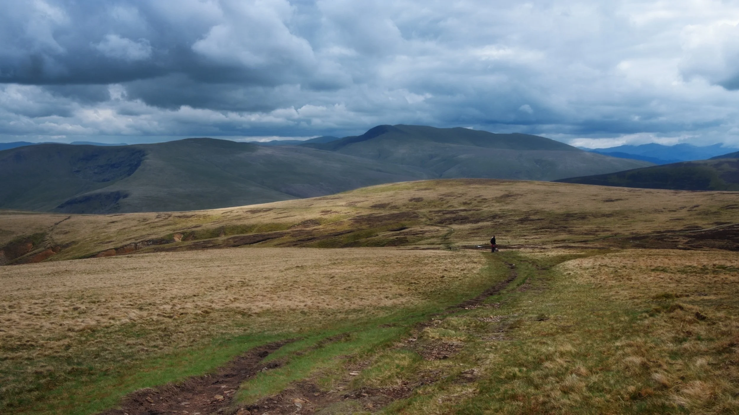
Grisedale, Lake District, Winter
Happy New Year, everyone! Here’s to a peaceful and gentler 2024.
Happy New Year, everyone! Here’s to a more peaceful and gentle 2024.
Though I’ve enjoyed time off work between Christmas and New Year, it’s not exactly been pleasant. Storm Gerrit washed across the UK, rendering most days miserably wet. There were even tornado warnings, largely unheard of in the UK.
On New Year’s Eve we learned that New Year’s Day promised much nicer conditions, and so we endeavoured to rise early and head into the Lake District for a solid yomp on the first day of 2024.
Conditions were certainly nicer, though you can never predict weather in the Lake District 100%. Hiking along the valley bottom of Grisedale towards the valley’s head, we were washed with wave after wave of fine drizzle. Thankfully, it never rained that hard, and in between the downpours we still managed to nab some glorious photos.
All photos taken on my Sony α7ii using my Pentax SMC 28mm F3.5 and Pentax SMC 55mm f2.0 prime lenses. RAWs developed in Lightroom using RNI Films’ Kodachrome film profiles, finalised in Photoshop.
Grisedale, Lake District, Winter by Ian Cylkowski is licensed under CC BY-NC-SA 4.0![]()
![]()
![]()
![]()
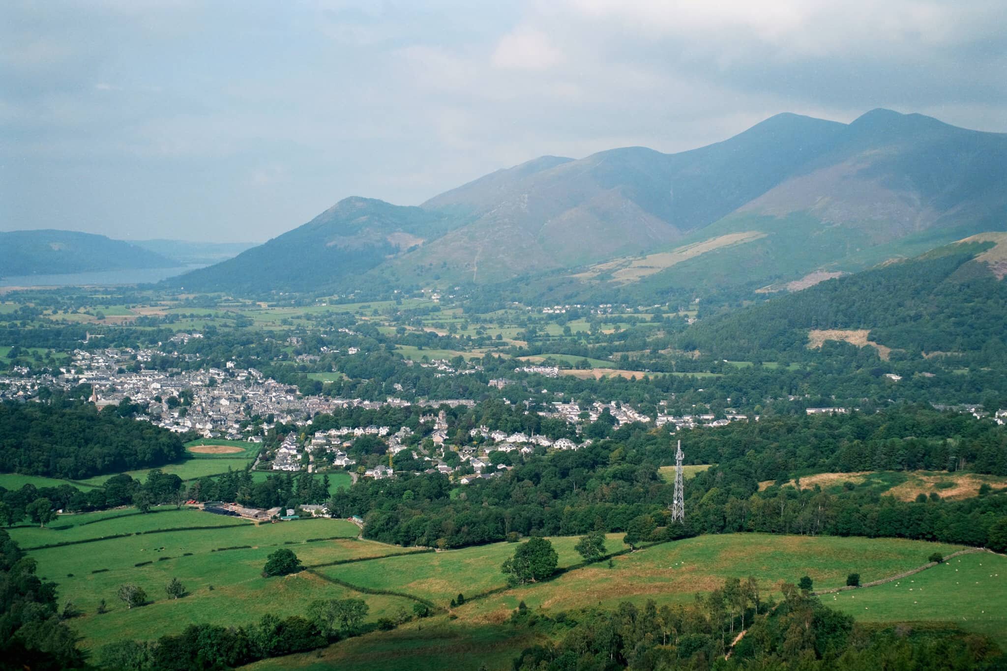
A sign of things to come. St. Sunday Crag (841 m/2,759 ft), rising above a sodden landscape with stormy clouds above.

Much of the first half of hiking into the valley comprised of dodging waves of drizzle. When one cleared up for long enough, I snuck this shot of Eagle Crag and Dollywaggon Pike (858 m/2,815 ft) battling with the low clouds.
Arriving closer to the turning point, we contemplated the condition of the trail on the other side of the valley. The hike in, on the south of the valley, is thankfully paved but had still been rendered in parts as a beck due to all the rain. I knew that the northern path back down the valley wasn’t in as good nick. So, from here, we turned back the same way we came in.
Thankfully, this was also when conditions started to clear up and the Helvellyn range of fells began to reveal themselves.
Eagle Crag with Nethermostcove Beck roaring down the fellside. A project was started in 2021 to return the valley’s main river, Grisedale Beck, back to its original “wiggly” form. To quote the Friends of the Ullswater Way: “As with many rivers in the UK, Grisedale Beck has historically been straightened and reinforced so that fields can be drained to improve grazing. This work was undertaken over 200 years ago and since then we have learned a lot about how straightened and reinforced rivers can negatively affect wildlife and increase flood risk. It should be noted that, despite the historic changes made to the river at the project site, this is still not particularly good grazing land, being very rough pasture and quite boggy in areas.”
Heading back down the valley, we kept turning back at the beautiful view at the head of Grisedale. Primarily to check on any incoming rain washing over the fells, but also to gawp at them. I enjoyed this composition as the trail seemingly leads across the image towards Nethermostcove Beck on the right. Pure mood.
One of the few pines left in the valley points a vibrant branch towards the beautifully cracked glacial erratic.
As the cloud cover finally starts to lift, Falcon Crag and Tarn Crag emerge from behind Dollywaggon Pike.
Light finally breaks through the clouds as we retreat further down the valley.
The beck streaming down from Blind Cove provides a nice leading line towards the vertical face of St. Sunday Crag.

The fells become obscured again. Another wave of rain heads towards us.
As another squall washes over us, I look across to the northern side of Grisedale and spot these bright becks cascading down the fellside. I very quickly nab a photo.
Soon, we near the foot of the valley and the rains were finally done for the afternoon. Look at that mountain backdrop.
Heading back towards the car, the hulking mound of Place Fell catches the warm winter light across its crags.
We elected for the scenic route back to Kendal, heading north out of Patterdale, through Matterdale, and onto the A65. That way we could turn off to head down St. John’s in the Vale and join the A591 back to Kendal. I kept my camera out, with the 55m attached to it, and grabbed this epic scene of Blencathra from the passenger’s side.
Down St. John’s in the Vale, I kept snapping happily, praying that at least one of the shots rendered sharp. Here, the deep cleft of Beckthorns Gill cuts into various crags of Clough Head.
Further south on the A591, near Thirlmere, Fisherplace Gill cuts a deep fissure within the crags of the Helvellyn massif. The farmhouses below look miniscule in comparison.
The distinctive shape of Browncove Crags, a subsidiary top of Helvellyn, with another deep gill caused by Helvellyn Gill.
Did you enjoy these photos?

Walla Crag, Lake District, Summer
A 4am start.
A 4am start.
The UK is on the cusp of a record-breaking heatwave, kicking in Sunday evening/Monday morning. Even before the real heatwave arrived, Sunday’s temperatures up here in Cumbria were looking to peak at around 26°C. Not only that, summer in the Lake District is easily its busiest time. So what to do?
Wake up before the sun rises and get to our destination before everyone else.
We decided on revisiting the small Walla Crag above Derwentwater, a new favourite after our first venture in autumn last year. Upon leaving the house we were greeted with something we didn’t expect before a heatwave, but probably should’ve anyway.
Rain.
We pulled up at the parking spot, and thankfully it only took 15 minutes or so for the rain to cease. By about 6:40am we started the walk up to Walla Crag.
Although the rain had cleared, it was still completely overcast even as temperatures quickly rose. The sun was not able to break through. So although light conditions were not the best, the views were still utterly magnificent.
All photos taken on my Fujifilm X-T2 using my Vivitar “Series 1” 28–105mm f2.8–f3.8 zoom lens. Shot using the Classic Chrome film simulation, developed in Capture One for iPad, cleaned up in Affinity Photo for iPad.
Walla Crag, Lake District, Summer by Ian Cylkowski is licensed under CC BY-NC-SA 4.0![]()
![]()
![]()
![]()
Across the fields from the Walla Crag path, Low Rigg looks diminutive against the imposing crag face of Clough Head, part of the Helvellyn range.
As we began the steep ascent up to Walla Crag, the views looking back opened up quickly. Here, Blencathra’s beautiful shape is unmistakeable.
The way up to Walla Crag, a short and sharp ascent.
Once up on the more level part of the fell, a small gate through the drystone wall allows you to take the more exploratory route to Walla Crag’s summit. Near the crag’s cliff edge, clear panoramas can be enjoyed across Derwentwater to the Grisedale fells.
Back along the cliff edge towards Blencathra, already there is some heather starting to appear. Give it another month or so for it to be in full resplendent bloom.
The smooth multi-peaked profile of Skiddaw, England’s 6th highest peak.
Walla Crag’s cliff face is lush, chock-full of fern, trees, heather, and loads of other flora. Lisabet discovered a small bilberry bush, and helped herself to a couple of the tart berries.
The summit of Walla Crag! Looking back north towards Skiddaw, a dominant presence on the Keswick skyline.
Derwentwater looks dry, with a couple of new islands becoming exposed as the water level drops.
One final composition from the summit, this time featuring Blencathra’s curved forms.
Walking towards the Jaws of Borrowdale.
Probably my favourite composition of the day. The drystone wall keeps livestock out of the Walla Crag area, allowing flora to flourish. In the distance is Derwentwater’s southern tip with the Borrowdale fells high above.
The other side of the same wall, featuring more of the Catbells ridge.
On the way back down the fell, I couldn’t resist revisiting this composition.
Pretty happy with how this shot of a family of fell ponies came out.
Did you like these photos?
High Pike, Lake District, Spring
There’s more to the Northern Fells of the Lake District than meets the eye.
There's more to the Northern Fells of the Lake District than meets the eye.
Nearing the end of our May break, and after having enjoyed the delights of Dash Falls, Lisabet and I decided that a reasonably high climb was in order.
Thankfully we had assistance! A former work colleague of mine turned good friend, Kate, lives in Northern Cumbria and is fell acquainted with the Northern Fells. After a coffee and a catch up, she guided us to a good parking area and we set off up the fell.
The Northern Fells really put me in mind of the Howgills: rolling, smooth hills with deep scarred valleys. Our goal for the day was to summit High Pike (658 m/2,159 ft), and in places the going was pretty steep. However, the views from the top are exquisite.
All photos shot on my Fujifilm X-T2 using two of my prime lenses: a Fujinon 23mm f/2.0 and an adapted Pentax SMC 55mm f/2.0. Images converted in Lightroom, then edited in Affinity Photo.
On our way up the easy-to-follow path and already the views are wide open and expansive. A great day for hiking.
The way up, with Potts Gill to our right. This area of the Northern Fells has been historically mined extensively, evidenced by fenced off shaft entrances and clear tracks.
The view from near the top of Potts Gill and its ripples. Dead centre is a transmitting station and in the far distance are the coastal Galloway mountains across the Solway Firth.
As the continue the climb, slivers of light dance across the fells and sink into the gills. The prominent peak is Brae Fell.
A 55mm composition of Brae Fell with deep gills scarring its flank.
But finally, after lots of huffing and puffing, summit! Looking south from the summit of High Pike, the fells criss-cross each other towards the back of Blencathra.
Even more stunning views to the east. To the left is Carrock Fell, and to the right are the crags of Bowscale Fell.
I ventured down the western slope of High Pike a little bit to get a clear view of the scene here. Great Lingy Hill and its extremely steep valley.
I kept returning to gawp at the view southwards, checking out the sheer southeastern crag faces of Bowscale Fell and Blencathra.
Heading back down the same route, the afternoon sun breaks through and scans across the scene ahead of us.
Back down on Caldbeck Moor there is gorse everywhere, smelling beautifully of coconut.
One last look back at the trail we took to High Pike. What a crackin' hike and a beautiful conclusion to our week.
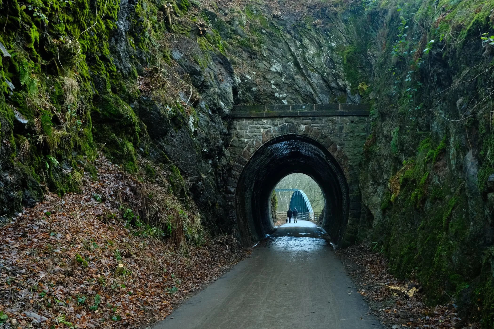
Keswick–Threlkeld Railway, Lake District, Winter
And now for something completely different.
And now for something completely different.
After yesterday’s thrilling circular hike around the gorgeous and epic Malhamdale, today we embarked on something a little more tourist-friendly and flat: the Keswick–Threlkeld Railway walk.
The 5km walk follows the route of the old Cockermouth, Keswick and Penrith Railway from Keswick to Threlkeld. It was constructed in 1864 with the goal of connecting the town of Cockermouth with the London and North Western Railway (LNWR) West Coast Main Line at Penrith. It closed to passengers and business in the 1960s and 1970s.
Much of the trail was badly damaged or totally destroyed by Storm Desmond in December 2015. Major restoration work was undertaken and the trail was upgraded and reopened in December 2020.
Lisabet and I met met up with me Dad near the start of the trail at Keswick, and followed the route all the way to Threlkeld and back, a good 6.2 miles and 17,000 steps later.
We were blessed with lifting hill fog, resulting in some incredible scenes of clouds whipping around the shoulders of nearby fells Lonscale Fell, Blencathra, and even some of the Helvellyn fells.
This route will definitely be one to revisit in Spring and Summer.
All photos taken on my Fujifilm X-T2 using my three prime lenses: a Fujinon 23mm f/2.0, a Laowa 9mm f/2.8, and an adapted Pentax SMC 55mm f/2.0. Images made in-camera, with no additional editing, using Øyvind Nordhagen‘s Overcast Fujifilm recipe.
The Keswick Hotel, which also seems to come with its own garage. At least, it used to.
The aforementioned Keswick Hotel Garage.

The Keswick–Threlkeld Railway trail starts near Keswick Leisure Centre, alongside the old station. I nabbed a sneaky shot of me Dad.
It wasn’t long before the trail started offering some lovely views along the River Greta towards the fells above Keswick. The main fell pictured here is a favourite of ours, Latrigg.
Where possible the Lake District National Park have tried to save and restore as many of the old Victorian bridges and tunnels as possible.
Near the “big” tunnel there’s a little commemorative sculpture, erected to celebrate the National Cycle Route and the Coast to Coast trail.
Into the “big” tunnel we go…
Again, beautifully preserved Victorian engineering, now with the added convenience of modern lighting and smooth, durable tarmac.
On the other side of the tunnel, panoramic views of the River Greta and Latrigg open up.
Despite being in winter, it was lovely to still see some colour about.

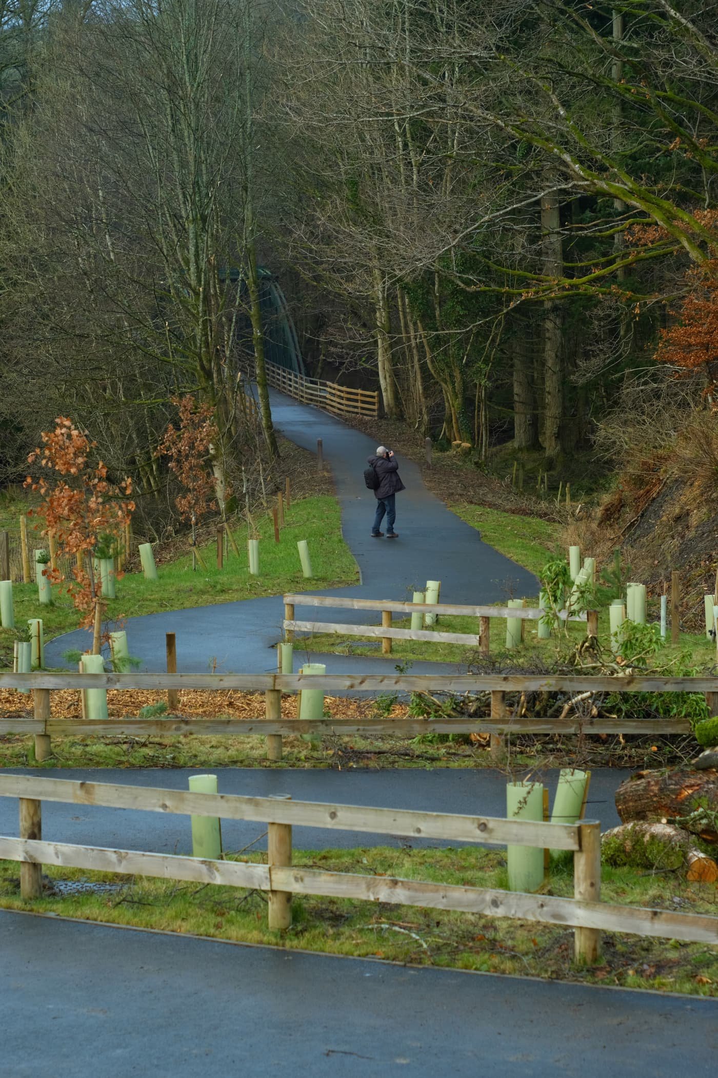
One of many of the newer bridges that criss-cross the winding River Greta.
Evidence of Storm Desmond, which scoured the river banks clean. You can still the level that river came up to during the storm. Land slips ahoy.
A nice little holiday village, Low Briery, alongside the River Greta.
The trees now denuded of their leafy vegetation, line the river and serve as a leading line towards Latrigg.
Onwards to the next bridge. There were plenty of other people around enjoying this trail. It was a good job we got started nice and early.
The next bridge to cross the River Greta. The Greta Gorge flattens out at this point, providing “in-bye” land for nearby hill farmers to use for their grazing flocks of sheep.

I wanted to play with lines and angles provided by this bridge, so I snapped on my ultra-wide 9mm lens for some fun compositions.
Not a bad spot for a bit of lunch.
The gorge created of the River Greta flattens out here, opening more perspectives of the Latrigg fells above.
To the north, the clouds were starting to lift from mighty Blencathra.
A solitary tree has survived erosion and storms against all the odds, and stands proudly in the middle of the river.
The excitement levels rise as we catch our first glimpse of Blencathra’s jagged peaks.
Additionally, to the east, the morning hill fog was wrestling with the crags of Clough Head, part of the Helvellyn range.
Beyond Latrigg, the crags of Lonscale, too, were freeing themselves of the morning’s mist.

The shoulder of Lonscale Fell high above the Greta Gorge.
Another relic of Victorian engineering, a small tunnel blasted through the crag leading to Rawsome’s Bridge.
Near Threlkeld, lots of trees were covered in beautiful and vibrant moss as the gorge walls closed in.
The end of the trail. Beyond the A66, Clough Head provides a dramatic backdrop as it tussles with the clearing fog and mist.
Blencathra’s craggy and jagged peaks, now nearly clear of morning mist.
Dad leads the way back to Keswick, happily snapping away.
There’s something wonderfully eldritch about wintery trees covered in moss.
Quite happy with this candid snap of me Dad.
Lonscale Fell again, now apparently losing its battle against the sky.
Blease Fell below Blencathra, and a band of mist clinging to its shoulder.
At around lunchtime, the sun finally broke through the thick cloud cover and illuminated these trees in golden light.
Overall, I can heartily recommend this trail. I look forward to returning in the spring and summer, when there’s more wildlife and flora about.
Walla Crag, Lake District, Autumn
Autumn has arrived.
Autumn has arrived.
The “life” from all the verdant vegetation is starting to wane, the ferns are turning rust-hued, and the leaves are beginning to drop. Autumn’s here, and I cannot wait for those autumnal colours.
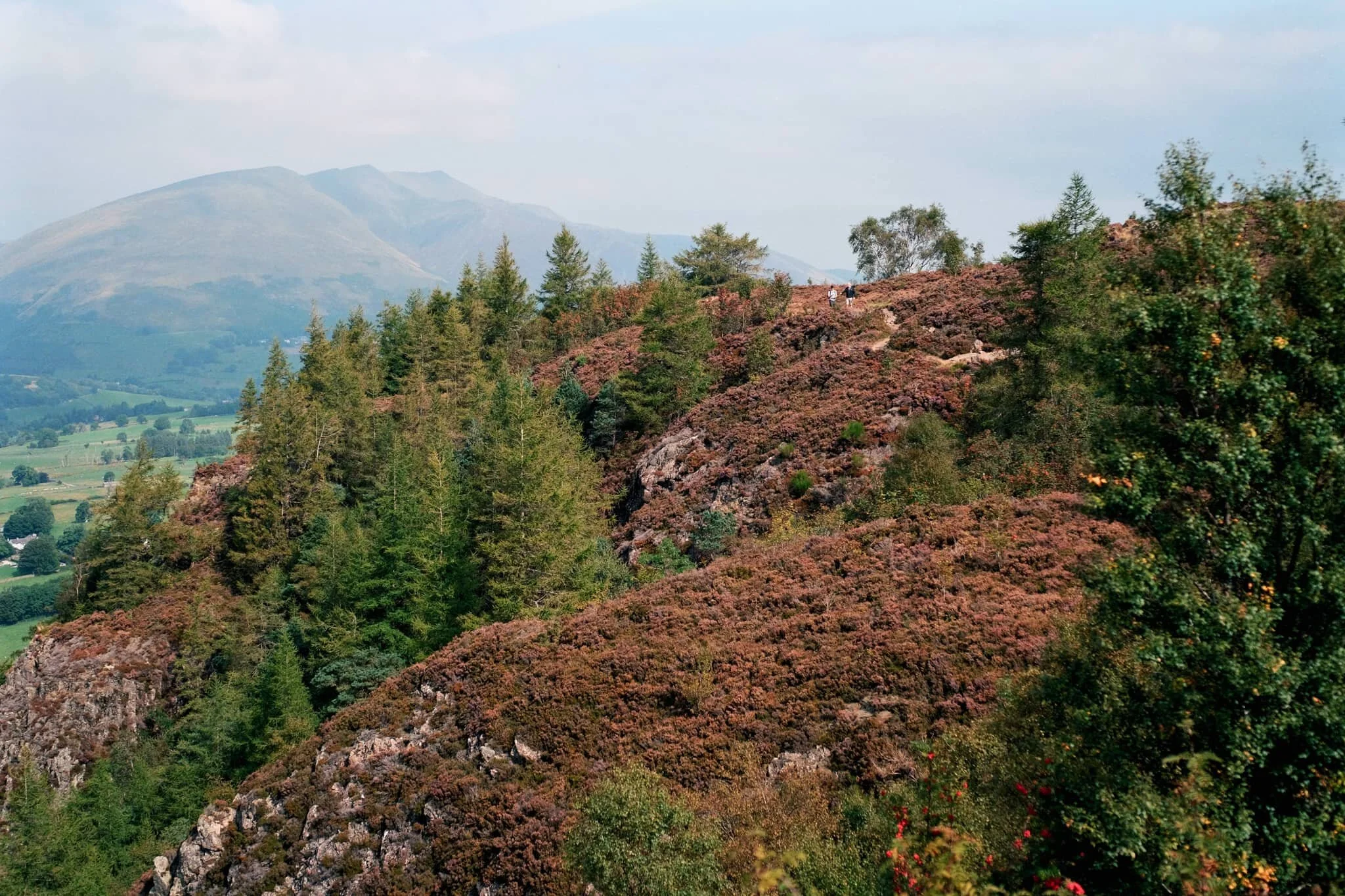
Whilst we wait, we decided today on a venture up a relatively small fell that we’ve never tried before: Walla Crag (379 m/1,243 ft).
At “only” 379 m tall it’s definitely one of the smaller fells, especially when compared to some of the giants in the area such as Skiddaw (931 m/3,054 ft) and Blencathra (868 m/2,848 ft). Nevertheless, what it lacks in height it makes up for in the jaw-dropping views it offers from its summit.
All photos shot on my Fujifilm X-T2 using my three prime lenses: a Samyang 35mm f/1.2, a Laowa 9mm f/2.8, and an adapted Pentax SMC 55mm f/2.0. Developed using RNI Films’ Kodak Ektar 100 profile.
Not far along the trail and already the views really open up. A couple enjoy a picnic in the sun with the backdrop of the Helvellyn fells behind them.
A row of Roman trees, Sorbus aucuparia, filled with their fruit frame the trail looking back to Blencathra in the distance.
The trail starts rising, offering up views looking back towards the likes of Lonscale Fell (715 m/2,346 ft).
By now the full profile of Skiddaw, its fells, and the smooth profile of Latrigg are fully exposed. It’s turning out to be a crackin’ day.
Plenty of other fell walkers were making their way up and down the trail. To the left in the distance is the magnificent slopes and peaks of Blencathra.
Skiddaw’s multi-peak shape looms of the bonny town of Keswick.
On our way up, the views towards the Derwentwater Fells, too, soon open up and our sense of anticipation grows.
Rowan trees and their vivid berries frame the Derwentwater fells on a somewhat hazy day.
Another lovely aspect to Walla Crag’s environment is the sheer abundance of pink heather everywhere.
The water level at Derwentwater is ridiculously low. New gravelly islands are reappearing and existing ones are gaining new shores.
It soon becomes apparent how much of a drop there is from Walla Crag’s northwestern face.
As more sun comes out, I spot another framing opportunity full of colour.
Looking back at the cliff-edge trail we followed. The amount of heather around Walla Crag is ludicrous.
Like, so much heather…
Aaaand… summit! Plenty of other folk enjoying the views from Walla Crag summit too. We stop for a quick bite and some water, taking the panorama in.
My ultra-wide 9mm lens was able to take in the vast panorama available from the summit of Walla Crag. One of the best views in the whole of the Lake District.
With my 55mm attached, it was time to pick out some smaller scenes amongst the vast panorama. The hazy conditions allowed for a wonderful layering affect with Derwentwater Fells.
Mighty Skiddaw looming above Keswick.
After taking everything in, it was time to follow the trail back down from the summit towards the main path off Walla Crag, with heather still in abundance.
Looking across the moorland and ferns, deep into the Jaws of Borrowdale.
Fellow hikers branch off from the path to take in the views towards the Helvellyn range, and Clough Head (726 m/2,382 ft) in particular.
Seemingly endless layers of fells in Borrowdale.
On the way back down off the fell, I spot this tree and arrange it underneath the peaks of Blencathra.
Magnificent Blencathra, demanding our constant attention as we climb off the shoulders of Walla Crag.
This is Armillaria mellea, or honey fungus. Apparently highly revered for its edible qualities, though a lot of UK species react with alcohol badly in people’s bodies causing nausea and vomiting. It’s generally best to parboil these mushrooms, and not consume alcohol for a day before and after eating them.
Follow other hikers along the trail back down to the car. The haze appears to lift somewhat around the Helvellyn fells.
The Helvellyn range above, with High Rigg and Low Rigg below.
Another fantastic day.
The Newlands Round, Lake District, Summer
The Great British Summer Heatwave has arrived.
The British Summer Heatwave has arrived.
In the week leading up to yesterday, Saturday 17th July, I had been planning a fell walk with my friend, Kate. She has more experience fell walking than I do, so we agreed to try a fell walk incorporating a view I’ve been after for years: Dale Head.
As the week progressed, it became apparent that a heatwave would arrive over the British Isles on the day of our walk. So we agreed to get up super early, drive to the location, and start the hike before temperatures became unbearable.
That was exactly the right decision.
Parking up at Honister Slate Mines, we started the steep ascent up the shoulder of Dale Head (753 m/2,470 ft) in comfortable temperatures of 15–16°C and a lovely breeze. By the time we had reached the final fell of the round, Robinson (737 m/2,418 ft), temperatures had risen into the mid-20s and the sun was strong. We had planned it well.
Kate turned out to be the perfect fell walking partner. Relaxed, sensible, and well-provisioned.
Here’s to more fell walking!
All photos taken on my Fujifilm X-T2 using two of my prime lenses: a Samyang 35mm f/1.2 and a Laowa 9mm f/2.8 lens. Images made 80% in-camera using a customised Classic Chrome film simulation, with minor corrections and edits afterwards in Lightroom and Affinity Photo.
The ascent up the shoulder of Dale Head from the Honister Slate Mine quickly opens these incredible views towards Buttermere and the Lorton Vale. Fleetwith Pike (648 m/2,126 ft) on the left was looking magnificent.
Looking back down the path we had taken, now the southern fells were becoming visible. Featuring Base Brown, Grey Knotts, and Green Gable.
At this height, the northern face of Kirk Fell (802 m/2,631 ft) was coming into view.
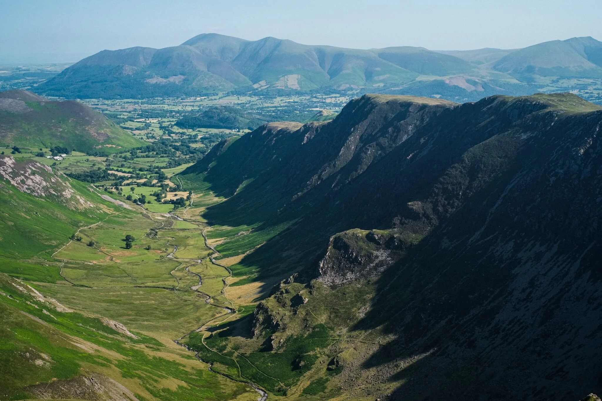
Aaaannddd… summit! The top of Dale Head, featuring its massive cairn and, more importantly, the ridiculous view if offers all the down the Newlands Valley towards the Skiddaw mountains. 8-years in waiting, and I loved every second.
Though the southern shoulder of Dale Head is steep, it is relatively smooth. By contrast, the fell’s northern face drops 400 m or so in less than a kilometre via Dale Head Crags. This enables this huge open view towards the High Spy and Maiden Moor ridge on the right, and the shoulder of Hindscarth on the left.
Probably my favourite shot of the day. The High Spy and Maiden Moor ridge, with its western flanks dropping sheer to the valley floor in a series of crags. In the distance, the Skiddaw range. Incredible.
Time to rest and refuel, which Kate and I were more than happy to do.
From Dale Head, there are unparalleled views towards the northern face of Fleetwith Pike and even, in the distance, mighty Pillar (892 m/2,927 ft).
West of Dale Head summit it’s easy enough to follow Hindscarth Edge to the next fell, drinking in the views all the way. Here is a clear shot of Buttermere and the massive High Stile range of fells above it.
The view back east shows the sheer craggy drop of its northern face as well as the crags of High Spy. In the distance is the Helvellyn range.
The way forward. Our next goal was to follow Hindscarth Edge and branch off to the right in order to summit Hindscarth itself.
Another view of Fleetwith Pike’s norther face and mighty Pillar in the centre. To the right is High Crag, part of the High Stile range.
Just below Hindscarth Crags I move towards the edge to nab this composition of the High Spy/Maiden Moor ridge with the Skiddaw and Blencathra ranges in the distance. Closer to me, a Swaledale lamb chews the cud and chills.
As we ascend Hindscarth, different views open up eastward. Below is Far Tongue Gill, to the right is Dale Head Crags, and left is Miners Crag and Red Crag of the High Spy/Maiden Moor ridge. In the distance, the Helvellyn range.
And another summit! This time, Hindscarth (727 m/2,385 ft), which offers a wonderful view down to the Newlands Valley floor and the Skiddaw range beyond.
Looking back at the High Stile range, I primarily took this shot for the British Isles-shaped cloud above the fells. You see it?
Being more west than when we started out, the High Spy/Maiden Moor ridge opens up and we can see Catbells (451 m/1,480 ft) as well. In the distance is the beautiful Blencathra fells.
A vertical composition from Hindscarth, looking down the trail to Scope End and the Skiddaw range in the distance. Just incredible views, no matter where you look.
High Spy, Maiden Moor, Catbells with beautiful Blencathra far away.
Kate happily resting by the wind shelter on Hindscarth. Across the valley is our next target, Robinson.
The way to the next fell, Robinson, involves returning back to the Hindscarth Edge trail and carrying onto the Littledale Edge trail towards Robinson. Before we did, I had to capture this panorama of fells from the Hindscarth summit.
Looking back at the Hindscarth Edge trail. Hard to believe we had walked all that way.
The Honister Pass, the top of which marked the start of our hike. We’ve made it quite far. In the distance is Glaramara (783 m/2,569 ft).
Nearing the top of Robinson. The small isolated fell of Rannerdale Knotts comes into view, followed by Crummock Water and Mellbreak above it. We can now see beyond the Lake District out to the Irish Sea.
And the third and final summit! Robinson was definitely the hardest to climb. The top is relatively flat but its sides a rather steep, with paths made largely of loose scree. By the time we reached Robinson, it was midday and temperatures were really starting to climb. I went scurrying around the summit with my ultra-wide lens to shot some of the interesting rock formations.
Utilising our previous route as a leading line towards the fells and featuring this wonderful craggy formation.
Fascinating geology. This is apparently an “olistostrome of disrupted, sheared and folded mudstone, siltstone and sandstone”. I also liked in this composition our the pile of rocks on the right mirrored the shape of the Skiddaw range to the left.
After the rather precipitous climb down Robinson’s northeastern flank to Buttermere Moss, I look back to shoot this profile of Robinson. More as a reminder of what we’d achieved.
What a wonderful day.