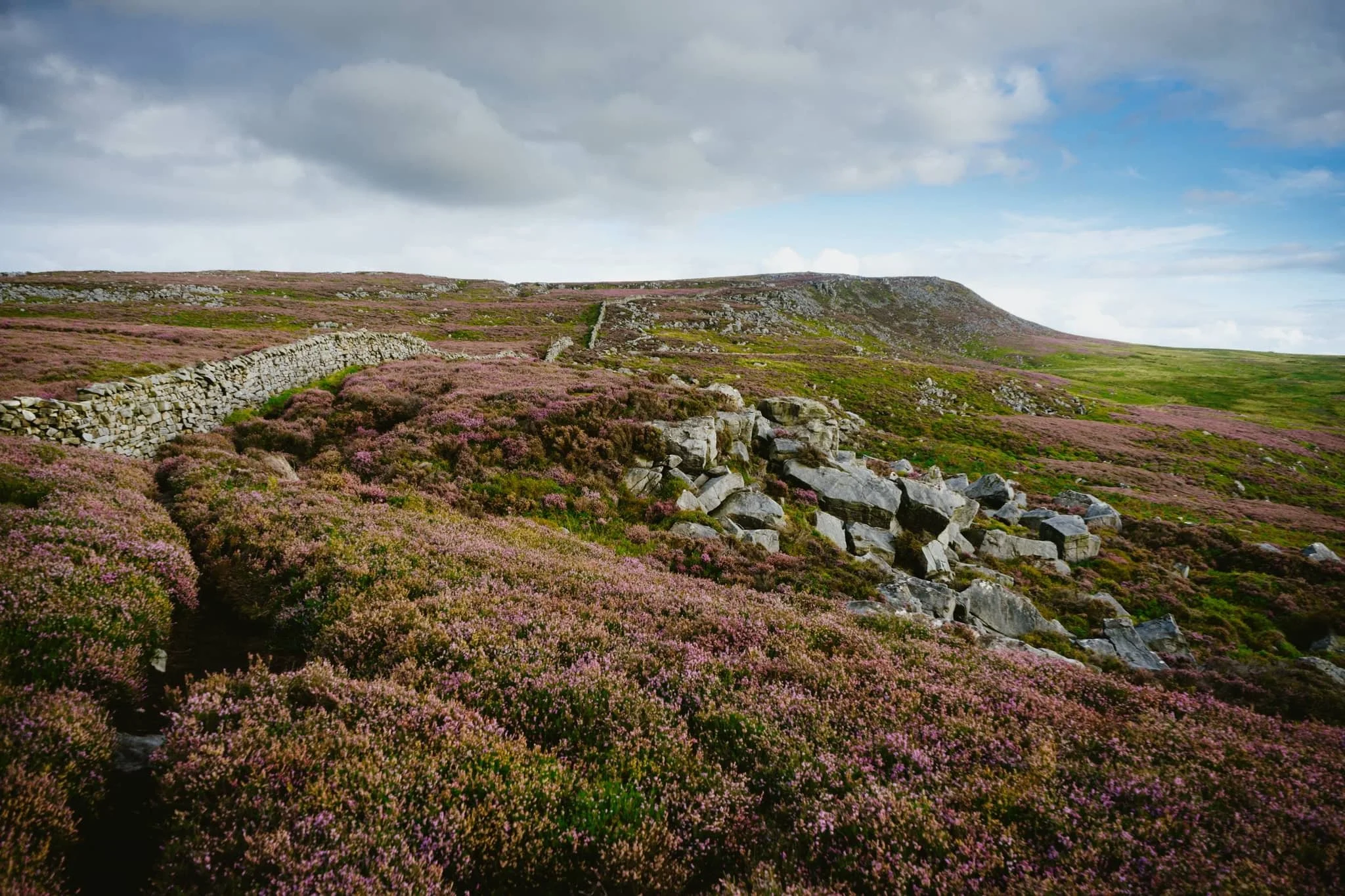
Clougha Pike, Forest of Bowland, Lancashire, Summer
The last few weeks have been… tough.
The last few weeks have been… tough.
Not long after our hike to and around Stockghyll Force, I managed to acquire some form of vertigo for a few days, which was decidedly unpleasant. The following week, my lovely Lisabet came down with a rather nasty summer cold, and I managed to fall down the stairs, spraining my wrist and severely bruising my butt. Then the week after, I caught Lisabet’s cold.
Yeesh.
Finally though, we were both fit and healthy, ready to get back out in nature. Following wise counsel from our nature expert friend, Andrew, we embarked on a completely new hike for us: the Clougha Pike circular.
Clougha Pike is the westernmost summit in the Forest of Bowland Area of Outstanding Natural Beauty. Many peaks in the Forest of Bowland are gristone fells surrounded by heather-covered peat moorland, blanket bog, and deep wooded valleys. Clougha Pike is no different, though its southern face drops away dramatically to the valley floor, and is clearly visible from most areas around Lancaster.
I ended up being in rather a lot of pain for this 10km hike. For reasons unknown to me, I slowly developed a blistering headache as the hike went on. This was paired with a sore neck (from having to look down at my footing a lot), sore knees (an every day occurrence), and painful feet (soles in my boots are now too thin).
Oh also, around the lower areas of the walk, having to deal with all the sheep flies and deer flies.
Despite all of this, the hike was gorgeous. The heather was in full bloom, covering the land and fells in carpets of mauve flowers. We were also experiencing the tail end of Storm Betty, so the higher we ascended the more the 50 mph winds punched our bodies.
All in all, it made for an epic day, and crackin’ photos.
Photos taken on my Sony α7ii using my Sony FE 28–70mm f3.5–5.6 OSS zoom lens. RAWS developed in Lightroom for iPad using RNI Films’ Fortia SP film emulation, then finalised in Affinity Photo 2 for iPad.
Clougha Pike, Forest of Bowland, Lancashire, Summer by Ian Cylkowski is licensed under CC BY-NC-SA 4.0![]()
![]()
![]()
![]()
Just a few yards from the car park and already we could see the extent of all the pinky purple heather blooming in the area.
This trail is the more direct route up to Clougha Pike. But for our hike, we chose a more circular clockwise route, skirting around the old quarries and heading towards Littledale.
The colour contrast between the heather and the grasses was proving too hard to resist.

A small scene of a gristone boulder being enveloped by all the heather, fern, and other moorland vegetation.
Increasingly I delight in finding, composing, and shooting these more intimate scenes in nature.

Miles upon miles of heather moorland give way to the lower folding valleys near Quernmore.
This point marked the beginning of our ascent of the fellside above Littledale, the site of a former quarry.
After crossing the infant River Conder via a concealed viaduct now known as Ottergear Bridge, we continued ascending the fellside above Cragg Wood. In the distance, Caton Moor’s windfarm catches the emerging light.
The trail gently lowered back down the fellside, but not before I captured this delightfully bucolic English view.
Another ascent ahead of us, the time the proper one that takes us all the way up to the Clougha Fell moorland plateau. The cascades of Sweet Beck presented a lovely little composition.
A swaledale yew enjoys the view from the fellside above Sweet Beck, with Caton Moor still drenched in light.
As we start ascending the back of Clougha Fell, the greens of the grass is gradually replaced the pinks of heather and the dark tones of peat, punctuated with boulders of gritstone.
The Caton Moor windfarm still getting soaked in afternoon light. In the distance, the dark clouds press down on the southwestern fells of the Yorkshire Dales.
After tacking the tricky and occasionally boggy trail up the back of Clougha, we finally joined the gravel shooter’s track and the moorland plateau. Rather then heading straight for the summit, we looped around to check this Andy Goldsworthy sculpture.
Of course, we had to take turns clambering into the “chambers” for some photos. The nice thing is, in the 50+ mph winds, these chambers were a nice respite from being constantly wrestled by the wind.
Making our way onto Clougha Fell, I had lots of fun making compositions from all the gritstone formations dotted about everywhere, such as with these boulders and the Yorkshire Dales Three Peaks in the distance.
A gritstone platform with solitary boulders, wrapped in heather, provided a nice scene towards Caton Moor and the dark fells in the distance.
It’s not quite Joe Cornish levels of composition skill, but I’ll get there one day.
A solitary gritstone boulder perched on the moorland plateau serves as a nice subject as it catches the light beneath the stormy skies.
From the summit of Clougha Pike, a mere 413 m/1,355 ft above sea level. Nevertheless, the views are gorgeous. From the summit we can see all the way across the Lune valley, towards Morecambe Bay.
From the summit, our way back down was immediately apparent. It was going to be rocky and steep.

100 m or so below the summit of Clougha Pike, a patch of smoothed gritstone boulders interspersed with heather provide me with another tasty composition.
From below Clougha Pike’s southern face, it’s easy to see how this is such a distinct and recognisable hill from many miles away.
A blast of light from the racing stormy clouds pulls all the gorgeous textures and colours from this scene.
One last look back at Clougha Pike, with heather everywhere, but we continued the descent down into the woodland toward the car park, fighting flies all the way.
Did you enjoy these photos?

Brockholes Nature Reserve, Lancashire, Winter
Recently I had the joy and honour of staying over at my best friend’s place in Preston, Lancashire.
Recently I had the joy and honour of staying over at my best friend’s place in Preston, Lancashire.
I lived in Preston for many years, leaving in 2012 to move further up north in Kendal, Cumbria. As such, it’s been a decade since I’ve seen Preston. The city has changed a lot.
Well, let’s be accurate. Some parts of the city, around the thriving University of Central Lancashire, have changed dramatically as the University continues to steer the economic direction of the city. Other parts of the city, away from the University, have barely changed or—worse—have totally degraded.
Both scenarios were a shock to see.
To cap off a lovely weekend, my friend and I had a wee waltz around the Brockholes Nature Reserve, located on the eastern outskirts of Preston. The Nature Reserve is situated in the flood plains of the River Ribble, and features the UK’s first floating visitor centre. The weather was pretty terrible all weekend, but thankfully during our hike it brightened up enough to actually snap some photos, in between the furious downpours.
All photos shot on my Fujifilm X-T2 using my Fujinon 23mm f/2.0 and Laowa 9mm f/2.8 prime lenses. Developed in Lightroom and finished in Affinity Photo.
As we left the car park to walk the 3-mile “Discovery” trail around Brockholes, the clouds above did not promise settled conditions.
Thankfully, the unsettled conditions resulted in this wonderfully clear double rainbow arching over the ponds.
Nearing the floating visitor village the sun broke out behind us, illuminating the landscape whilst another dark squall approaches overhead.
The floating visitor village was designed by Adam Khan Architects, built by Price & Myers, and opened to the public in 2011. It houses shops, an exhibition area, an activity room for schools and community groups, a restaurant and a conference centre.
After knocking back an espresso with a flapjack, it was time for one last prowl around this magnificent feat of architecture.
Roudsea Wood & Mosses, Cumbria, Spring
Time for somewhere a little different.
Time for somewhere a little different.
Cumbria being what it is, a sparsely-populated county full of nature, there’s a fair few Nature Reserves never mind the actual Lake District National Park. We’ve explored a few of them previously, for example Foulshaw Moss and Watchtree. This time we ventured south of Windermere and Newby Bridge, beyond the pretty village of Haverthwaite.
This is Roudsea Wood & Mosses Nature Reserve.
The Reserve is located on the eastern side of the Levens Estuary, west of Cartmel. Roudsea Wood is one of Britain’s most important woodland sites, combining varied geology (limestone and slate) with alluvial soils and fens. This has created a woodland full of bio- and geodiversity. Just east of the woods are the bogs of Roudsea Moss, an important area of peat and wildlife, especially Ospreys.
Further west of the Nature Reserve one can hike the Cumbria Coast Way towards the Levens Estuary itself, an extension of the humongous mudflats and sands of Morecambe Bay.
Roudsea: a place of bog, woodland, and sea.
Definitely one for Lisabet and I to keep coming back to.
All photos shot on my Fujifilm X-T2 using my three prime lenses: a Samyang 35mm f/1.2, a Laowa 9mm f/2.8, and an adapted Pentax SMC 55mm f/2.0. Developed using RNI’s Kodachrome film profiles.
Around Roudsea Mosses, the bogs are home to isolated clusters of Scots Pines, making for rather minimalist compositions.
Pleasing to the eye, especially the sense of distance.
The bogs of Roudsea Moss are thankfully easy to navigate courtesy of these boardwalks. They also enable compositions by offering a leading line.
Back into the woods we go.
Delightful tree textures to photograph.
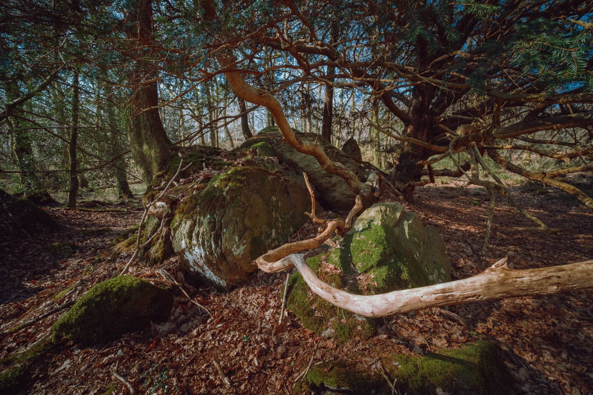
Upon entering the Woodland Trail the geography quickly changes from open bog to a limestone woodland. Lisabet and I spotted this otherworldly scene consisting of tree branches snaking around a limestone outcrop.
There were barely any clouds on our outing, allowing for the sun to penetrate through the canopy of the woodland.
More snake-like tree trunks and branches, with the addition of fungi, which Lisabet was happy to find.
This part of Roudsea Woods was a lot more green, and we were happy to see the beginnings of bluebells appearing on the woodland floor.
Just a moment, when the light caught only this tree.
Flora blossoming everywhere.
An early Bluebell. We’ll be seeing more of these in the various woods around Cumbria within the next fortnight or so.
A weird configuration of a limestone outcrop with a tree root system slowly enveloping it.
Tendrils of wood everywhere, gorgeous textures abound.
After completing the Woodland Trail, we joined the Cumbria Coast Way west towards the Levens Estuary. I knew there would be sand and mudflats ahoy as the estuary is linked to Morecambe Baby, but I had no idea there were these rocky outcrops along the coast.
I was transfixed when I saw these rocks and their beautiful lines, textures, and patterns. I had to come get some compositions in.
We were blessed with a rather beautiful, if hazy, day to be exploring this area of South Cumbria.
Looking back across Levens Estuary towards How Barrow and the Cartmel fells.
An almost impossibly perfect composition that I couldn’t resist on our way back to the car.

Foulshaw Moss, Lake District, Spring
Foulshaw Moss is a pretty cool place. It’s a raised bog, named so because this type of bog rises in height over time as a result of peat formation.
A few days after my 36th birthday, back in 2019, my Dad came up to stay with us (he wasn’t living in Cumbria at the time). One of the places we explored with him was Foulshaw Moss, a raised bog just south of the imposing Whitbarrow Scar. We explored the area and took photos; at the time, I was mainly shooting on my Google Pixel 3XL with a shiny new Moment 18mm Wide v2 lens I’d got for my birthday.
A year and a few weeks on we visited Foulshaw Moss again, this time under totally different circumstances.
To accommodate social distancing measures due to the Coronavirus, the Cumbria Wildlife Trust (who manage the area) have blocked off certain dog-legs of the trail and turned it into a one-way route, encouraging people to keep their distance from each other.
On our visit we only saw one other man, who was busy bird spotting.
Foulshaw Moss is a pretty cool place. It’s a raised bog, named so because this type of bog rises in height over time as a result of peat formation. They’re very rare in Britain as historically they’re usually drained and used for planting trees. As raised bogs are acidic and wet habitats, their environment tends to encourage more unusual flora and fauna that can cope with the conditions.
In 2010 the Cumbria Wildlife Trust reintroduced a rare dragonfly to the site, the White-faced darter (Leucorrhinia dubia). In 2014 a pair of Ospreys nested at Foulshaw Moss, and have returned every year since. Hides have been erected at various points along the boardwalk trail for visitors to view the Ospreys through telescopes.
My lovely Lisabet, phone in hand ready to capture some minutiae she spots. In the distance is the south face of Whitbarrow Scar.
A pair of silver birch trees, standing out from the bog.
A young sapling reach for the sun.
A large part of Foulshaw Moss consists of this watery “graveyard” of silver birch, looking like brush strokes on a canvas.
A young rowan sapling, Sorbus aucuparia. In times gone by twigs from this tree were used to drive cattle to the pasture for the first time in spring to ensure their health and fertility.
There’s also plenty of bulrush, or Typha latifolia, in the bogs of Foulshaw Moss. By the time we saw them their heads had erupted, leaving these fluffy cotton-like tails everywhere.
Also in abundance—sprouting from the carcasses of various birch trees—is Fomes fomentarius, or the Hoof Fungus (you can see why). It’s apparently very useful as a tinder to start fires. Who knew?
The road back to Whitbarrow Scar, one of the biggest limestone escarpements in the Lyth Valley.
A solitary Scots Pine, Pinus sylvestris.
The open and expansive part of Foulshaw Moss. No blue skies on this day, in fact totally matte with clouds. On the right you can see a familiar resident of acidic bogs: cottongrass, or Eriophorum.
The only bird hide left open to accommodate social distancing measures.