Bullpot, Yorkshire Dales, Summer
The heatwave has finally ended.
The heatwave has finally ended.
After a week of temperatures pushing 30°C consistently with barely any air movement, today was looking a more comfortable 23°C with some wind.
About a month ago we embarked on one of our favourite local-ish walks, Barbondale in the Yorkshire Dales. On that occasion I was somewhat distracted by the sheer number of deer flies biting chunks out of me. Part of the Barbondale hike we did involved clambering over into Bullpot. We resolved to return to Bullpot for a deeper exploration of the area’s famous pot holes, gills, and caves, particularly Ease Gill Kirk.
After a lazy start, today was that day.
The dry ravines around the junction between Ease Gill and Leck Beck display some wonderful geology. Like a lot of the Yorkshire Dales, the gills here are largely made of limestone, which is porous and soluble in water. Limestone landscapes lend themselves to lots of waterfalls and cave systems, and the Ease Gill Cavern System is the longest and most complex cave system in Britain. As a result of the areas various potholes and caves, the area around Ease Gill Kirk is largely dry and full of “extinct” waterfalls, ready for exploration.
Which we duly did as best we could.
All photos taken on my Fujifilm X-T2 using my three prime lenses: a Samyang 35mm f/1.2, a Laowa 9mm f/2.8, and an adapted Pentax 55mm f/2.0 lens. Images made 80% in-camera using a customised Velvia film simulation, with minor edits afterwards in Lightroom and Affinity Photo.
The way to Ease Gill Kirk, after passing Bullpot Farm. The old farmhouse now serves as the base for the Red Rose Cave & Pothole Club.
The ruins of two lime kilns provide a hint as to the industrial heritage of this area.
The Bullpot valley features lots of dry stone walls that expertly trace the steep curves of the dale.
Layers and layers.
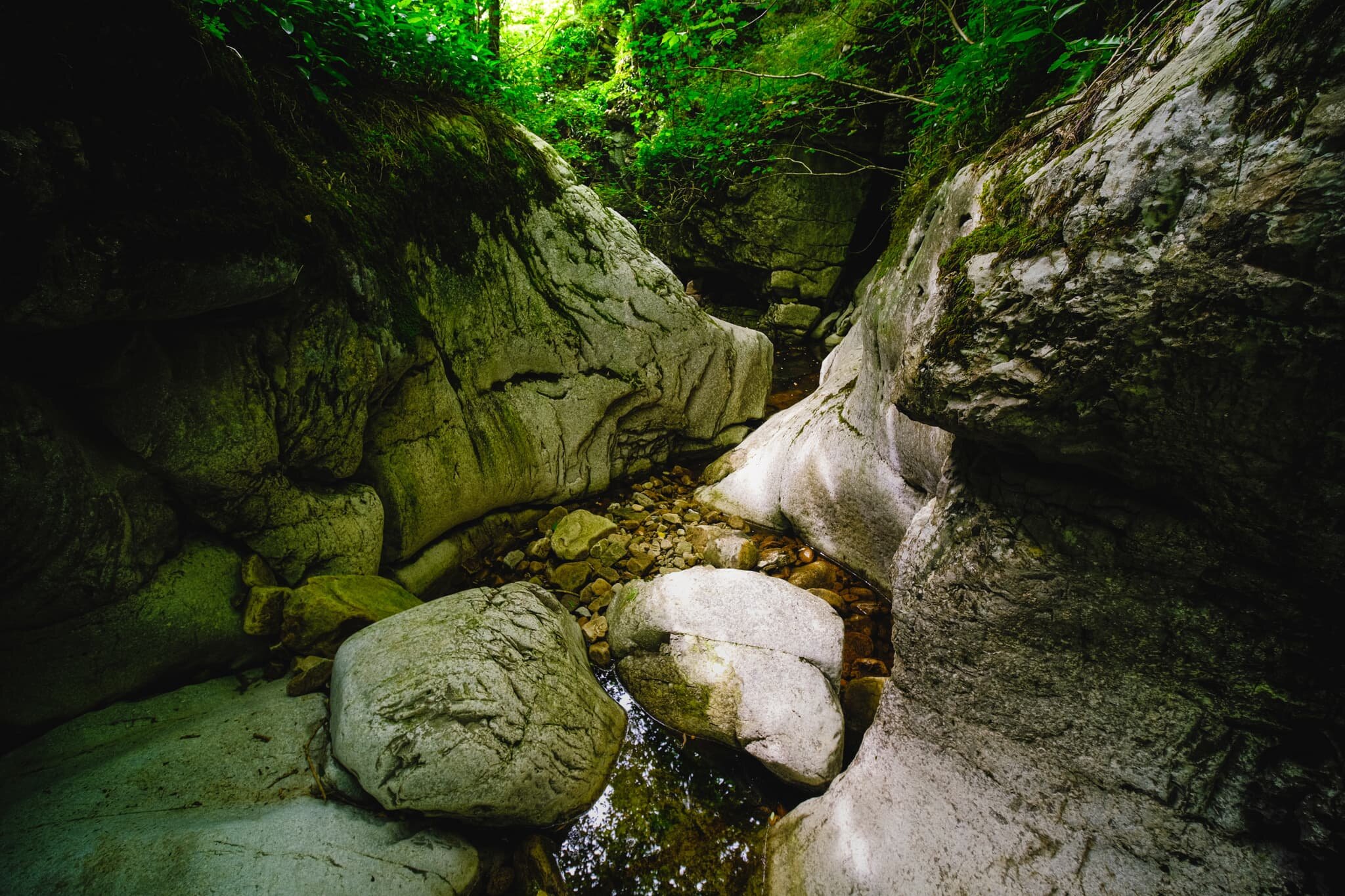
Our first sighting of the dry Ease Gill Kirk. Now to clamber down and explore…
We followed the dry river bed east up Ease Gill to find our first “waterfall”. The gill is largely dry now—save for periods of heavy rain—as the limestone geology of the area is water soluble. This means that the water that once carved out this river and waterfall now disappears further up the gill into a deep cave system, many miles below.
Nature is a fantastic sculptor. It was amazing to see the curves and forms created in the rock face by the waterfall that used to flow over here.
A stagnant pool is all that remains of this extinct waterfall.
We exited back out of Ease Gill and made our way south to Ease Gill Kirk, following the dry river.
Lisabet and I scrambled down the gorge created by Ease Gill to capture this world of twists and turns. I’ve no doubt that with a good pair of wellies on, and a more adventurous spirit, you could follow this largely dry gorge a good distance. For now, this will do.
The ruins of Hellot Scales Barn, which serves now as a signpost of sorts for locating Ease Gill Kirk.
On the way back to Bullpot Farm I, of course, had to snap some compositions of the brilliant dry stone walls here.
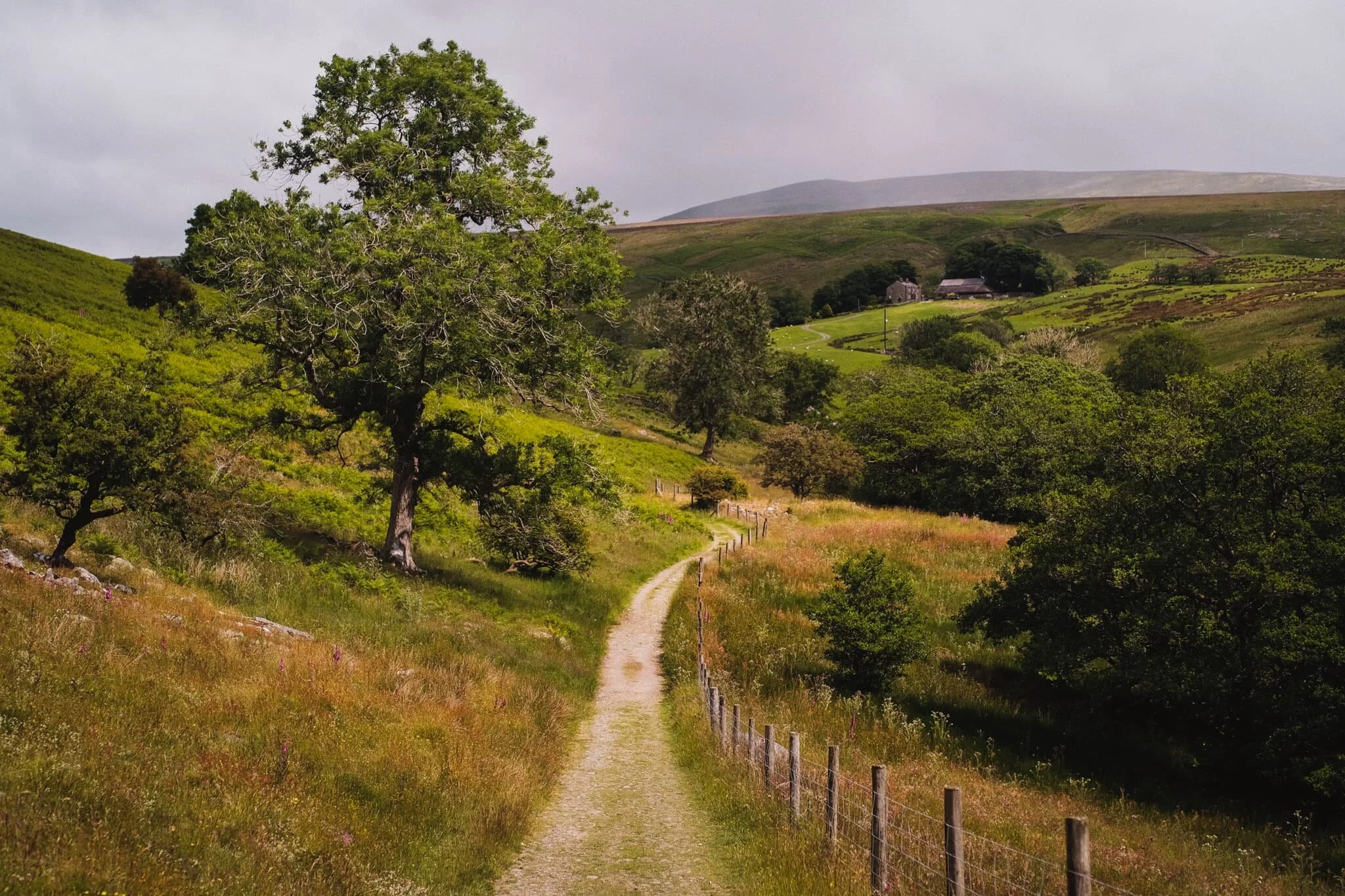
Just follow the wall all the way back to Bullpot Farm. I suspect in wetter months the path between Bullpot Farm and Ease Gill Kirk would be consistently boggy.
The area near Bullpot Farm is home to lots of shake holes, not to mention one of the main entrances into the Ease Gill Cave System, ominously called “Bull Pot of the Witches”.
I saw it, lined it up, and took a photo of it.
One final shot of the wall of fells above Barbondale known as Calf Top.
Barbondale, Yorkshire Dales, Summer
With the summer heat increasing once again, it was time to revisit a favourite of ours: Barbondale.
With the summer heat increasing once again, it was time to revisit a favourite of ours: Barbondale.
The last time we hiked around the area was May last year (2020). One year and a month on, tree felling operations in the area are still very much in action. I wonder why a lot of the woodland in the valley is being cut down and replanted? It is quite sad to see.
We decided to slightly extend our usual walk from Barbon village to the valley clearing by following the trail up the gill between Barbon Low and High Fell. This lands you at Bullpot, home to the Red Rose Cave & Pothole Club. There are a myriad of caves and potholes here that give access to the area’s famous Easegill cave system.
My experience of the hike was unfortunately somewhat marred. As the temperatures are rising again, I decided to go hiking in shorts rather than a pair of trousers. This was a mistake as Barbondale was busy with activity from Deer Flies, a few of which decided to persistently attack my calves for that delicious blood fuel.
Lesson learned: don’t wear shorts when hiking in the summer.
Photos taken on my Fujifilm X-T2 using my Samyang 35mm f/1.2 lens. Images were 80% made in-camera using a “Nostalgic Negative” recipe, with minor edits later in Lightroom and Affinity Photo.
The Churchmouse at Barbon, a lovely little café and cheese shop in Barbon village.
Not bad views if you live in Barbon.
Barbon is proper lovely, and though technically in Cumbria it very much feels like a rural Yorkshire village.
St. Bartholomew’s church. The present structure dates from the early 19th century, located slightly south of an earlier chapel built in the 1600s.
Machinery at rest is now dotted about the area of Barbondale woods. I’m sure there are pertinent reasons to cut down so many trees, but it’s still saddening.
The peak of Barbon Low Fell, set against what remains of Barbondale woods and some summer wildflowers.
The lack of trees in Barbondale has revealed at one thing to me, though: there are a lot of Foxglove (Digitalis purpurea) in the valley.
Steadily making our way towards Barbondale head and its clearing.
The view that greets you once you pop out of what’s left of Barbondale woods. The weather was… interesting. It was warm, but with gusts of alternating cold and hot air, interspersed with gentle sprays of rain from a distant cloud burst. You can see the cloud burst above Crag Hill in the distance.
After stopping for lunch by Barbon Beck, we took the trail up the gill between Barbon Low and High Fell, clearly signposted for Bullpot. The deer flies were ravenous.
The views looking back down to Barbondale started to open up as we climbed higher.
A beam of light scans across Barbondale and its highest fell, Calf Top.
Red Rose Cave & Pothole Club at the top of Bullpot, formerly the home of Bullpot Farm. We could’ve continued the hike around the head of this tiny valley to explore Easegill, but the flies had pissed me off enough so we made our way back to the car.
The top of the trail between Bullpot and Barbondale. Damp, fecund, and full of flies.
A curious Swaledale ewe pauses her meal to ensure I’m not a threat.
The road back to Barbon village. High in Barbondale woods to the right, you can spot Barbon Manor.
Arriving back at Barbon village, complete with relief from getting away from all the flies and guilt for letting them annoy me so much.