High Pike, Lake District, Spring
There’s more to the Northern Fells of the Lake District than meets the eye.
There's more to the Northern Fells of the Lake District than meets the eye.
Nearing the end of our May break, and after having enjoyed the delights of Dash Falls, Lisabet and I decided that a reasonably high climb was in order.
Thankfully we had assistance! A former work colleague of mine turned good friend, Kate, lives in Northern Cumbria and is fell acquainted with the Northern Fells. After a coffee and a catch up, she guided us to a good parking area and we set off up the fell.
The Northern Fells really put me in mind of the Howgills: rolling, smooth hills with deep scarred valleys. Our goal for the day was to summit High Pike (658 m/2,159 ft), and in places the going was pretty steep. However, the views from the top are exquisite.
All photos shot on my Fujifilm X-T2 using two of my prime lenses: a Fujinon 23mm f/2.0 and an adapted Pentax SMC 55mm f/2.0. Images converted in Lightroom, then edited in Affinity Photo.
On our way up the easy-to-follow path and already the views are wide open and expansive. A great day for hiking.
The way up, with Potts Gill to our right. This area of the Northern Fells has been historically mined extensively, evidenced by fenced off shaft entrances and clear tracks.
The view from near the top of Potts Gill and its ripples. Dead centre is a transmitting station and in the far distance are the coastal Galloway mountains across the Solway Firth.
As the continue the climb, slivers of light dance across the fells and sink into the gills. The prominent peak is Brae Fell.
A 55mm composition of Brae Fell with deep gills scarring its flank.
But finally, after lots of huffing and puffing, summit! Looking south from the summit of High Pike, the fells criss-cross each other towards the back of Blencathra.
Even more stunning views to the east. To the left is Carrock Fell, and to the right are the crags of Bowscale Fell.
I ventured down the western slope of High Pike a little bit to get a clear view of the scene here. Great Lingy Hill and its extremely steep valley.
I kept returning to gawp at the view southwards, checking out the sheer southeastern crag faces of Bowscale Fell and Blencathra.
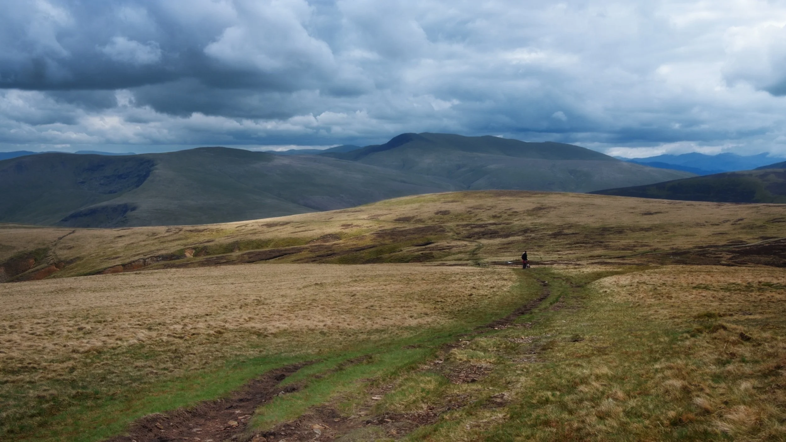
Heading back down the same route, the afternoon sun breaks through and scans across the scene ahead of us.
Back down on Caldbeck Moor there is gorse everywhere, smelling beautifully of coconut.
One last look back at the trail we took to High Pike. What a crackin' hike and a beautiful conclusion to our week.
Bowscale Tarn, Lake District, Summer
We kicked off Father’s Day weekend by revisiting the Mosedale valley in the Northern Fells of the Lake District.
We kicked off Father’s Day weekend by revisiting the Mosedale valley in the Northern Fells of the Lake District.
The last time we hiked Mosedale was back in March of this year, during a visit to my Dad’s. It was our first time in this quiet valley and we were floored with the sights and views. The nice weather probably helped.
This time we endeavoured to hike the public bridleway up Mosedale’s southern side. Following this takes you all the way to Bowscale Tarn and, if you want, onwards up to Bowscale Fell (702 m/2,303 ft). Adventurous fell walkers can then extend this hike by venturing further south to summit Blencathra itself (868 m/2,848 ft).
We decided not to summit Bowscale Fell this time round; the humidity was proving quite draining. Nevertheless, Bowscale Tarn was delightful. It’s flanked on all sides except the north by sheer walls of crag. The tarn is reportedly 60 ft deep and—so the legend goes—is home to a pair of talking, immortal fish.
The more you know!
All photos shot on my Fujifilm X-T2 using my three prime lenses: a Samyang 35mm f/1.2, a Laowa 9mm f/2.8, and an adapted Pentax SMC 55mm f/2.0. Images 80% developed in-camera using a customised Provia film simulation, with minor finishing edits in Lightroom and Affinity Photo.
After parking up at the small car park, generously provided by the Quaker Meeting Hall, I had to quickly snap this photo. It’s such an English Lake District village scene.
Tiny Mosedale village, nestled underneath Carrock Fell (661 m/2,169 ft).
Onto the public bridleway near Bowscale hamlet and up we go! We certainly weren’t the only ones on this trail, and nor should we expect to be given it’s summer in the Lake District. Nevertheless, this part of the national park definitely sees fewer visitors.
The flat-bottomed floor of Mosedale, perfectly sculpted by historical glaciers.
Looking back, I spot Lisabet nabbing a photo of a bee on some thistle. The cloudy conditions increased the humidity of the day, and soon we were rather damp in sweat.
Plenty of Swaledale ewes about in Mosedale, with their spring lambs getting to know the valley and the fells.
Around this part of the bridleway, the gradient starts to increase as we near Bowscale Tarn. I paused to catch me breath briefly, and looked back to shoot the light scanning across the shoulder of Bowscale Fell.
Bowscale Tarn is near. The bridleway skirts around this moraine “lip” that keeps the water where it is. Ahead is the wall known sensibly as Tarn Crags.
We made it to the tarn, preceded by fellow hikers and families enjoying the delights of nature.
An unnamed gill cuts through the crags of Bowscale Fell and drops into the deep and dark water of Bowscale Tarn.
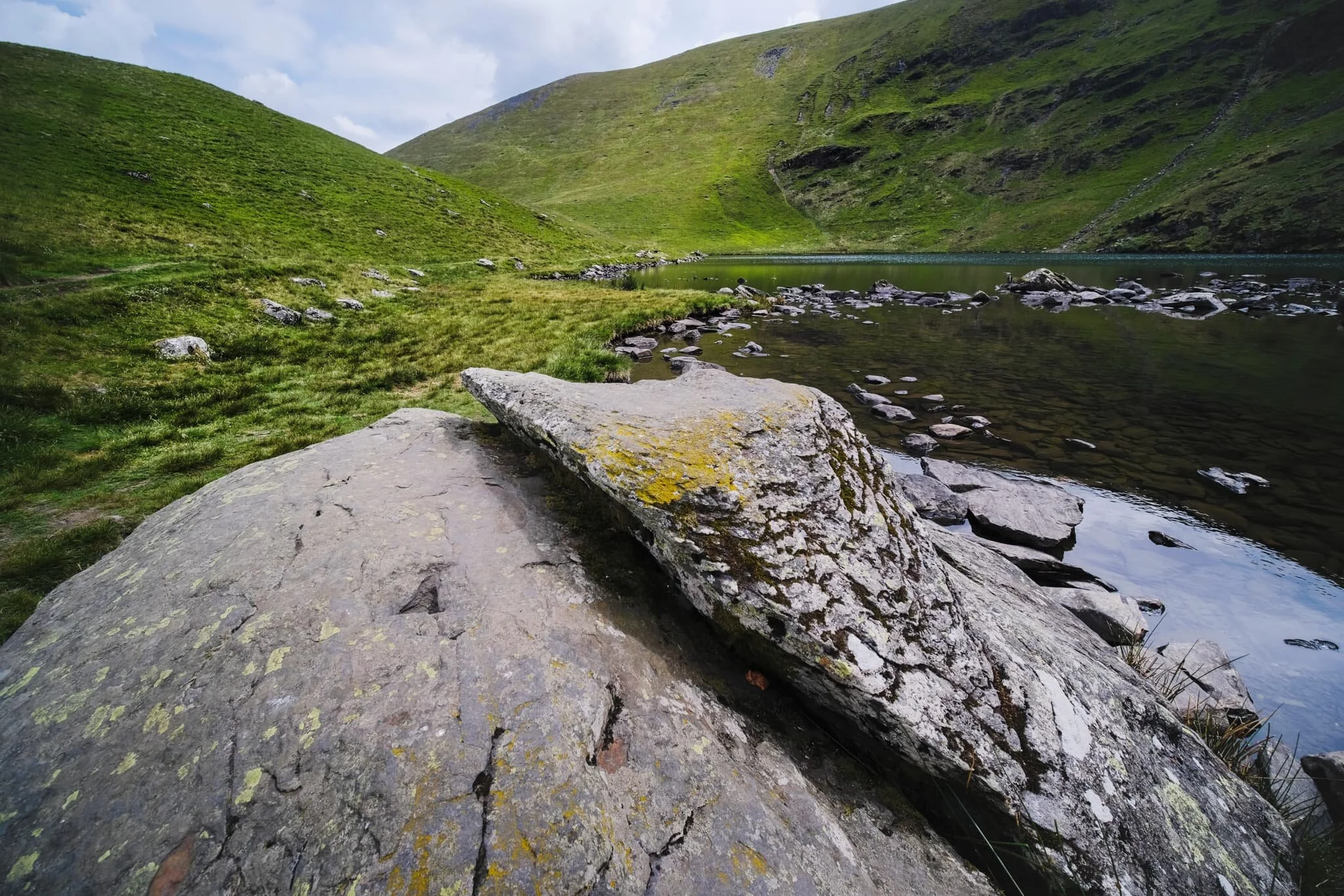
Near the outflow of the tarn, which drops to the valley floor as Tarn Sikes, one can find some impressive boulders offering compositional interest.
A wider view of Bowscale Tarn, surrounded by Tarn Crags. The summit of Bowscale Fell is just up and to the left.
Lisabet and I gingerly navigated around the shore of the tarn, picking out photos along the way. Underneath Tarn Crags, I looked back to the outflow of the tarn and made this composition incorporating the distant summit of Carrock Fell.
Even on the steep slopes of Tarn Crags, you’ll find ewes and their lambs.
This part of the shoreline marks the end of our way around the tarn. A brief opening in the clouds above softly illuminates the scene.
There were plenty of kids hopping, skipping, and jumping around the rocks and boulders of the tarn.
After pausing for lunch, it was time to head back down. I equipped my 55mm lens for some longer perspectives, including this one of Lisabet and the northern side of Mosedale.
Salutations to the splendour of nature? Or stretching her shoulders and back out?
After following the clear, yet admittedly steep, path directly back down to the valley floor, we paused at the footbridge to admire this view all the way back up Mosedale.
Roundhouse Farm marks the point where we join the path on the northern side of Mosedale and head back east to the car. The earliest parts of the farm date back to 1702 AD.
Swaledales were being smart and sought shelter from the sun underneath the trees and in the shade of the drystone walls. They look about ready for a good clipping (shearing).
Behold! Some blue sky at last!
The full extent of Mosedale from near the village. What a crackin’ day.

Pandemic Peregrinations: Caldbeck Common, Cumbria, Winter
Today it was time for something a little different.
Today it was time for something a little different.
It’s been about a month since I last saw my Dad, and during that time a 3rd National Lockdown came into effect. My Dad’s in his 60s, lives alone, and has Type II Diabetes, so he’s in our “bubble”. So we thought it we were overdue for a visit, and zipped up to North Cumbria to check in on him, and get some exercise in whilst there.
Dad took us to Caldbeck Common, an area northeast of the northern Lake District fells. We hiked up alongside Carrock Beck and followed the old miner’s track towards High Pike (658 m/2,159 ft), snapping plenty of photos along the way.
Temperatures were around -3°C and there was a strong wind about, so it were pretty raw on the face. Refreshing and invigorating, though. More importantly, we got to hang out with my Dad, which is always a pleasure.
Most photos taken on my Fujifilm X-T2 using a Samyang 35mm f/1.2 lens. The horse photos were taken on my Google Pixel 3XL. All developed using one of RNI’s Kodachrome film profiles.
My lovely Lisabet, shooting some water action. This is Carrock Beck, which begins life from the eastern slopes of High Pike. The beck actually flows over the road here, so vehicles habitually have to ford the river.
Dad and Lisabet, nattering away, getting whipped by the cold winds.
We saw lots of delightful icicle formations by the side of the miner’s track. Miniature worlds of their own.
Looking back the way we came. In the far distance is the snow-capped escarpment known as the North Pennines. It peaks at Cross Fell (893 m/2,930 ft), which is the highest summit in England outside of the Lake District.
Managed to snap this candid shot of Dad, with Carrock Fell (661 m/2,169 ft) behind. I think Dad’s face is testament to the sub-zero temperatures blowing right into our faces.
Carrock Fell from the miner’s track. The fell is fairly unique in England as it’s largely made from Gabbro, a rough igneous rock that’s normally found on the Isle of Skye. Rock climbers like as it’s quite “grippy”.
The head of the Carrock Beck valley, which summits at High Pike. Still a bit of snow around.
Looking back at the Carrock Beck valley from further down. Plenty of gorse (Ulex europaeus) around here, but not yet in flower.
As we started driving out of Caldbeck Common we stopped the car to let a herd of fell horses through. I wound down the window to snap some phone photos when one gorgeous member of the herd stopped and poked through the window for a sniff.
Didn’t have any tasty carrots or apples on me, I’m afraid.
Beautiful creatures.