
Walla Crag, Lake District, Summer
A 4am start.
A 4am start.
The UK is on the cusp of a record-breaking heatwave, kicking in Sunday evening/Monday morning. Even before the real heatwave arrived, Sunday’s temperatures up here in Cumbria were looking to peak at around 26°C. Not only that, summer in the Lake District is easily its busiest time. So what to do?
Wake up before the sun rises and get to our destination before everyone else.
We decided on revisiting the small Walla Crag above Derwentwater, a new favourite after our first venture in autumn last year. Upon leaving the house we were greeted with something we didn’t expect before a heatwave, but probably should’ve anyway.
Rain.
We pulled up at the parking spot, and thankfully it only took 15 minutes or so for the rain to cease. By about 6:40am we started the walk up to Walla Crag.
Although the rain had cleared, it was still completely overcast even as temperatures quickly rose. The sun was not able to break through. So although light conditions were not the best, the views were still utterly magnificent.
All photos taken on my Fujifilm X-T2 using my Vivitar “Series 1” 28–105mm f2.8–f3.8 zoom lens. Shot using the Classic Chrome film simulation, developed in Capture One for iPad, cleaned up in Affinity Photo for iPad.
Walla Crag, Lake District, Summer by Ian Cylkowski is licensed under CC BY-NC-SA 4.0![]()
![]()
![]()
![]()
Across the fields from the Walla Crag path, Low Rigg looks diminutive against the imposing crag face of Clough Head, part of the Helvellyn range.
As we began the steep ascent up to Walla Crag, the views looking back opened up quickly. Here, Blencathra’s beautiful shape is unmistakeable.
The way up to Walla Crag, a short and sharp ascent.
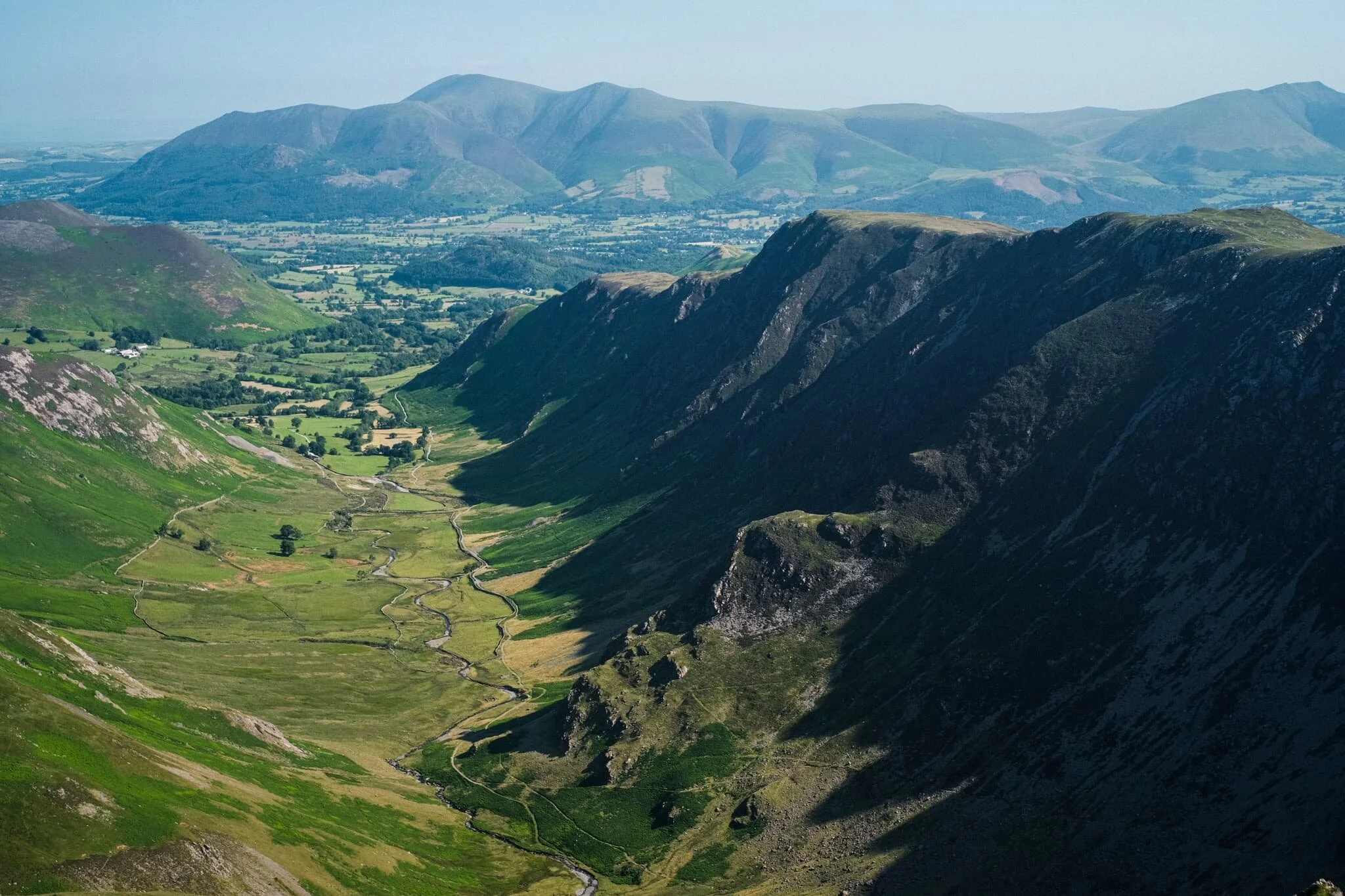
Once up on the more level part of the fell, a small gate through the drystone wall allows you to take the more exploratory route to Walla Crag’s summit. Near the crag’s cliff edge, clear panoramas can be enjoyed across Derwentwater to the Grisedale fells.
Back along the cliff edge towards Blencathra, already there is some heather starting to appear. Give it another month or so for it to be in full resplendent bloom.
The smooth multi-peaked profile of Skiddaw, England’s 6th highest peak.
Walla Crag’s cliff face is lush, chock-full of fern, trees, heather, and loads of other flora. Lisabet discovered a small bilberry bush, and helped herself to a couple of the tart berries.
The summit of Walla Crag! Looking back north towards Skiddaw, a dominant presence on the Keswick skyline.
Derwentwater looks dry, with a couple of new islands becoming exposed as the water level drops.
One final composition from the summit, this time featuring Blencathra’s curved forms.
Walking towards the Jaws of Borrowdale.
Probably my favourite composition of the day. The drystone wall keeps livestock out of the Walla Crag area, allowing flora to flourish. In the distance is Derwentwater’s southern tip with the Borrowdale fells high above.
The other side of the same wall, featuring more of the Catbells ridge.
On the way back down the fell, I couldn’t resist revisiting this composition.
Pretty happy with how this shot of a family of fell ponies came out.
Did you like these photos?
The Newlands Round, Lake District, Summer
The Great British Summer Heatwave has arrived.
The British Summer Heatwave has arrived.
In the week leading up to yesterday, Saturday 17th July, I had been planning a fell walk with my friend, Kate. She has more experience fell walking than I do, so we agreed to try a fell walk incorporating a view I’ve been after for years: Dale Head.
As the week progressed, it became apparent that a heatwave would arrive over the British Isles on the day of our walk. So we agreed to get up super early, drive to the location, and start the hike before temperatures became unbearable.
That was exactly the right decision.
Parking up at Honister Slate Mines, we started the steep ascent up the shoulder of Dale Head (753 m/2,470 ft) in comfortable temperatures of 15–16°C and a lovely breeze. By the time we had reached the final fell of the round, Robinson (737 m/2,418 ft), temperatures had risen into the mid-20s and the sun was strong. We had planned it well.
Kate turned out to be the perfect fell walking partner. Relaxed, sensible, and well-provisioned.
Here’s to more fell walking!
All photos taken on my Fujifilm X-T2 using two of my prime lenses: a Samyang 35mm f/1.2 and a Laowa 9mm f/2.8 lens. Images made 80% in-camera using a customised Classic Chrome film simulation, with minor corrections and edits afterwards in Lightroom and Affinity Photo.
The ascent up the shoulder of Dale Head from the Honister Slate Mine quickly opens these incredible views towards Buttermere and the Lorton Vale. Fleetwith Pike (648 m/2,126 ft) on the left was looking magnificent.
Looking back down the path we had taken, now the southern fells were becoming visible. Featuring Base Brown, Grey Knotts, and Green Gable.
At this height, the northern face of Kirk Fell (802 m/2,631 ft) was coming into view.
Aaaannddd… summit! The top of Dale Head, featuring its massive cairn and, more importantly, the ridiculous view if offers all the down the Newlands Valley towards the Skiddaw mountains. 8-years in waiting, and I loved every second.
Though the southern shoulder of Dale Head is steep, it is relatively smooth. By contrast, the fell’s northern face drops 400 m or so in less than a kilometre via Dale Head Crags. This enables this huge open view towards the High Spy and Maiden Moor ridge on the right, and the shoulder of Hindscarth on the left.
Probably my favourite shot of the day. The High Spy and Maiden Moor ridge, with its western flanks dropping sheer to the valley floor in a series of crags. In the distance, the Skiddaw range. Incredible.
Time to rest and refuel, which Kate and I were more than happy to do.
From Dale Head, there are unparalleled views towards the northern face of Fleetwith Pike and even, in the distance, mighty Pillar (892 m/2,927 ft).
West of Dale Head summit it’s easy enough to follow Hindscarth Edge to the next fell, drinking in the views all the way. Here is a clear shot of Buttermere and the massive High Stile range of fells above it.
The view back east shows the sheer craggy drop of its northern face as well as the crags of High Spy. In the distance is the Helvellyn range.
The way forward. Our next goal was to follow Hindscarth Edge and branch off to the right in order to summit Hindscarth itself.
Another view of Fleetwith Pike’s norther face and mighty Pillar in the centre. To the right is High Crag, part of the High Stile range.
Just below Hindscarth Crags I move towards the edge to nab this composition of the High Spy/Maiden Moor ridge with the Skiddaw and Blencathra ranges in the distance. Closer to me, a Swaledale lamb chews the cud and chills.
As we ascend Hindscarth, different views open up eastward. Below is Far Tongue Gill, to the right is Dale Head Crags, and left is Miners Crag and Red Crag of the High Spy/Maiden Moor ridge. In the distance, the Helvellyn range.
And another summit! This time, Hindscarth (727 m/2,385 ft), which offers a wonderful view down to the Newlands Valley floor and the Skiddaw range beyond.
Looking back at the High Stile range, I primarily took this shot for the British Isles-shaped cloud above the fells. You see it?
Being more west than when we started out, the High Spy/Maiden Moor ridge opens up and we can see Catbells (451 m/1,480 ft) as well. In the distance is the beautiful Blencathra fells.
A vertical composition from Hindscarth, looking down the trail to Scope End and the Skiddaw range in the distance. Just incredible views, no matter where you look.
High Spy, Maiden Moor, Catbells with beautiful Blencathra far away.
Kate happily resting by the wind shelter on Hindscarth. Across the valley is our next target, Robinson.
The way to the next fell, Robinson, involves returning back to the Hindscarth Edge trail and carrying onto the Littledale Edge trail towards Robinson. Before we did, I had to capture this panorama of fells from the Hindscarth summit.
Looking back at the Hindscarth Edge trail. Hard to believe we had walked all that way.
The Honister Pass, the top of which marked the start of our hike. We’ve made it quite far. In the distance is Glaramara (783 m/2,569 ft).
Nearing the top of Robinson. The small isolated fell of Rannerdale Knotts comes into view, followed by Crummock Water and Mellbreak above it. We can now see beyond the Lake District out to the Irish Sea.
And the third and final summit! Robinson was definitely the hardest to climb. The top is relatively flat but its sides a rather steep, with paths made largely of loose scree. By the time we reached Robinson, it was midday and temperatures were really starting to climb. I went scurrying around the summit with my ultra-wide lens to shot some of the interesting rock formations.
Utilising our previous route as a leading line towards the fells and featuring this wonderful craggy formation.
Fascinating geology. This is apparently an “olistostrome of disrupted, sheared and folded mudstone, siltstone and sandstone”. I also liked in this composition our the pile of rocks on the right mirrored the shape of the Skiddaw range to the left.
After the rather precipitous climb down Robinson’s northeastern flank to Buttermere Moss, I look back to shoot this profile of Robinson. More as a reminder of what we’d achieved.
What a wonderful day.
Newlands Valley, Lake District, Summer
On the Sunday following the Saturday, we threw caution to the wind and visited the Lake District for a solid hike.
On the Sunday following the Saturday, we threw caution to the wind and visited the Lake District for a solid hike.
Signs were looking good that, for a Sunday morning, the Lake District wasn’t looking too busy (use Safer Lakes to check the busyness of Lake District car parks). We drove to Keswick and plotted a hiking route from the town onto the Cumbria Way towards the Lingholm Estate, where we’d pause for refreshment. Then we’d continue on the Cumbria Way towards the foot of Catbells, and break off into the Newlands Valley, terminating at Little Town and circling back all the way to Keswick.
All in all, about 16 km and 25,000 steps. Pretty good.
It was a stupendously beautiful day in the Lake District, and the Newlands Valley in particular was looking absolutely incredible.
Please enjoy these photos.
All photos shot on my Fujifilm X-T2 using my three prime lenses: a Samyang 35mm f/1.2, a Laowa 9mm f/2.8, and an adapted Pentax SMC 55mm f/2.0 lens. Images were made 80% in-camera using a customised Velvia film simulation, with minor edits afterwards in Lightroom and Affinity Photo.
Crossing the Greta Bridge here signifies the start of our walk onto the Cumbria Way. Given the weather we’d had, the river was looking very low.
The Cumbria Way bisects an open field, with clear views towards the Newlands fells one way and the Skiddaw range the other.
Pure Lake District. Mountains above, Herdwick sheep below.
Hot Herdwick ewes and their lamb find shade wherever they can. They’re about ready for clipping (shearing) I reckon.
Just south of the village of Portinscale, you enter a heavily wooded area. This is all part of the Lingholm Estate, the centre of which is a Victorian mansion built in the 1870s by Alfred Waterhouse.
The grounds of Lingholm Estate, and especially the Walled Gardens and Kitchen, are beautifully maintained.
Beatrix Potter made sketches of the octagonal kitchen garden and referred to it as her original inspiration for Mr McGregor’s garden in The Tale of Peter Rabbit.
Rhododendrons and foxglove. Pretty colour contrasts.
Everything was looking so lush in the gardens.
A brief window of light penetrates the woodland canopy, illuminating this uprooted tree.
After popping out of Overside Wood you enter what is simply known as The Park, and are greeted with the northern ridge of Catbells (451 m/1,480 ft), one of the Lake District’s most famous mountains.
Our journey that day did not involve Catbells, especially with the veritable train of people following the path up to the fell’s summit. Instead we took the minor road around the mountain’s western shoulder, heading towards the Newlands Valley. Already, the views look wonderful.
One of Keswick’s more familiar sights is the knobbly profile of Causey Pike (637 m/2,090 ft).
Rowling End (433 m/1,421 ft) slightly obscuring Causey Pike with Birkrigg Farm below.
Looking back the way we came, with the massive Skiddaw range looming above Keswick. My lovely Lisabet looking, well, lovely!
Following the minor road around Catbells’ western shoulder, the views open up more and more, giving us extensive panoramas of the Newlands fells.
An ultra-wide perspective of our way forward as the Newlands valley opens up.
The fell in the centre that looks like it’s had a massive bite taken out of it is Robinson (737 m/2,418 ft). The name might seem unusual, given most fell and place names in Cumbria have Old Norse origins. Apparently the land that included the fell was purchased by a Richard Robinson centuries ago. The fell, at the time unnamed, became known as Robinson’s Fell, and eventually shortened to Robinson.
I suspect this minor road was once a miner’s road (see what I did there?). According to the OS Map, ahead of us at Yewthwaite was some disused old mining works beneath Maiden Moor (576 m/1,890 ft).
We followed the trail through the old mines and onward towards Little Town. Ahead of us, Ard Crags’ (581 m/1,906 ft) pointy profile is revealed. But what I’m looking for is just around the corner of High Crags…
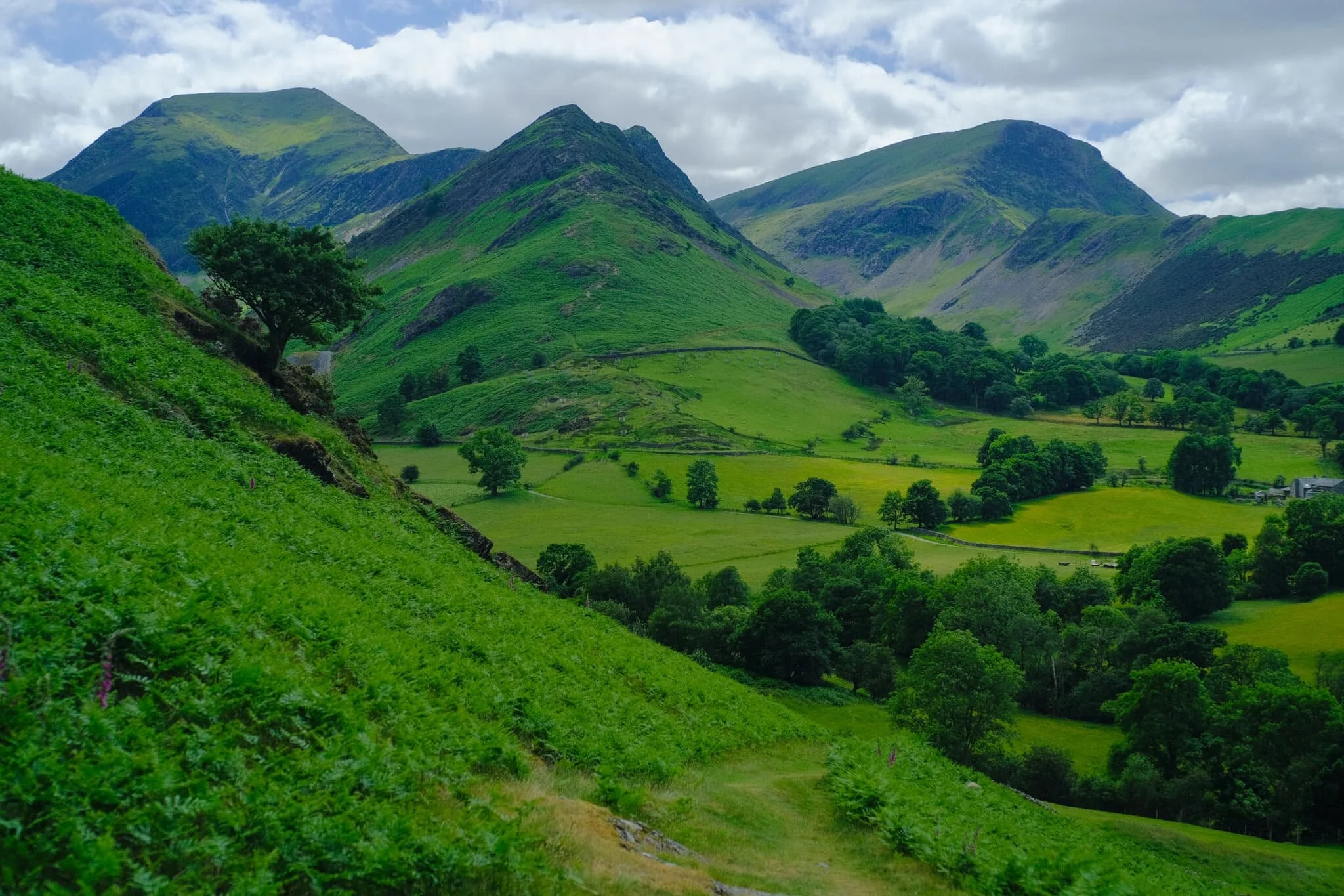
And there it is. In my mind, one of the best views in all of Lakeland. Dale Head (753 m/2,470 ft) on the left, Hindscarth (727 m/2,385 ft) in the middle, and Robinson on the right.
Looking back the other way, we are treated to another gorgeous Lakeland summer scene. Herdwick sheep in the valley bottom, the Skiddaw range above.
We stopped for refreshment and delicious ice cream at Catbells Café in Little Town. Ard Crags, like a toddler amongst the grown-ups, still very much demanded our attention. Not a bad spot for refreshments, eh?
After pausing at Little Town we circled back and followed the trail all the way back towards the Cumbria Way and Keswick. This part of the trail is closer to the valley bottom and more open, giving us different views entirely.
A pleasing composition of ancient trees, farm fence and gate, and the Skiddaw range.
Lots of the standalone trees around this part of the Newlands Valley I suspect are rather old, and remnants from when this valley was cleared of woodland by Viking settlers.
It also means you find strange and unusual trees, such as this beauty. Ever seen a tree trunk like it?!
From one field into another, following an ancient lane back towards Skiddaw.
One final look back at the Newlands fells, with groups of Texel sheep and lambs dotted about.
Back on the minor road underneath Catbells. Lisabet grabs a rare selfie, with Blencathra looking mighty in the distance.
Stormwater Bridge, a suspended footbridge, indicates our approach is near Keswick. The Skiddaw range looms ever closer.
Herdwick lambs seeking shade from the warm day. They are born jet black, save for tufts of white around their ears. As they age, their face and legs turn white and their fleece becomes a dark, chocolatey brown. It’s not until they’re 2-3 years of age that they get their first clip (shear), which reveals the characteristic grey Herdwick fleece underneath.
Zen Cow is contemplating existence…
Keswick town was busy. Time to navigate through the crowds in order to get back to the car.
What a wonderful day it was.