
Hull Pot, Yorkshire Dales, Winter
A month since my last post.
A month since my last post.
I do apologise.
The weather in January has been, well, shocking to say the least. We endured three named storms: Henk, Isha, and Jocelyn. Isha, in particular, was one of the most powerful storms the British Isles have seen since 2000.
Additionally, we’ve had periods of below freezing temperatures, resulting in widespread ice.
It’s been… interesting.
Thankfully, the weekend just gone, it was nice enough for us to finally head out. We chose the Hull Pot route from Horton-in-Ribblesdale in the Yorkshire Dales. I had an inkling that there’d still be some snow liggin’ about in the Dales, contributing to a water-saturated landscape and, hopefully, a waterfall flowing into Hull Pot.
And we finally saw it.
All photos taken on my Sony α7ii using my Pentax SMC 28mm F3.5, Pentax SMC 55mm f2.0, and Rokinon 14mm f2.8 ED AS IF UMC prime lenses. RAWs developed in Lightroom, edited and finalised in Photoshop.
Hull Pot, Yorkshire Dales, Winter by Ian Cylkowski is licensed under CC BY-NC-SA 4.0![]()
![]()
![]()
![]()
The characteristic drystone walls of the Yorkshire Dales remained steadfast in the face of all the snow we’ve had recently, resulting in these snowdrifts piled up against them.
Our way forward. We knew on this day that there’d only be 2-3 hours of good light, and boy was it dramatic.
Looking back at where we came from. We were very much on the edge of two weather systems. Conditions over Horton-in-Ribblesdale saw blue skies and puffy clouds, but closer to Pen-y-Ghent it was blowy, dark, and stormy, giving us epic light.
A good sign: A small waterfall where there usually isn’t at Horton Scar. Above, Pen-y-Ghent fights with the dark and stormy clouds.
Further up the bridleway, the site of an extinct waterfall below Pen-y-Ghent, which is now obscured by clouds laden with snow. A burst of sun to our right picks out the details in the land.
And there she is, finally ticked off my bucket list. England’s largest natural hole, Hull Pot, with Hull Pot Beck tumbling down 60ft into the chasm. As mentioned before on this blog, Hull Pot is a large cave where the roof has collapsed, which has resulted in this massive chasm below Pen-y-Ghent. With my ultra-wide 14mm equipped, I was able to capture the entire scene.
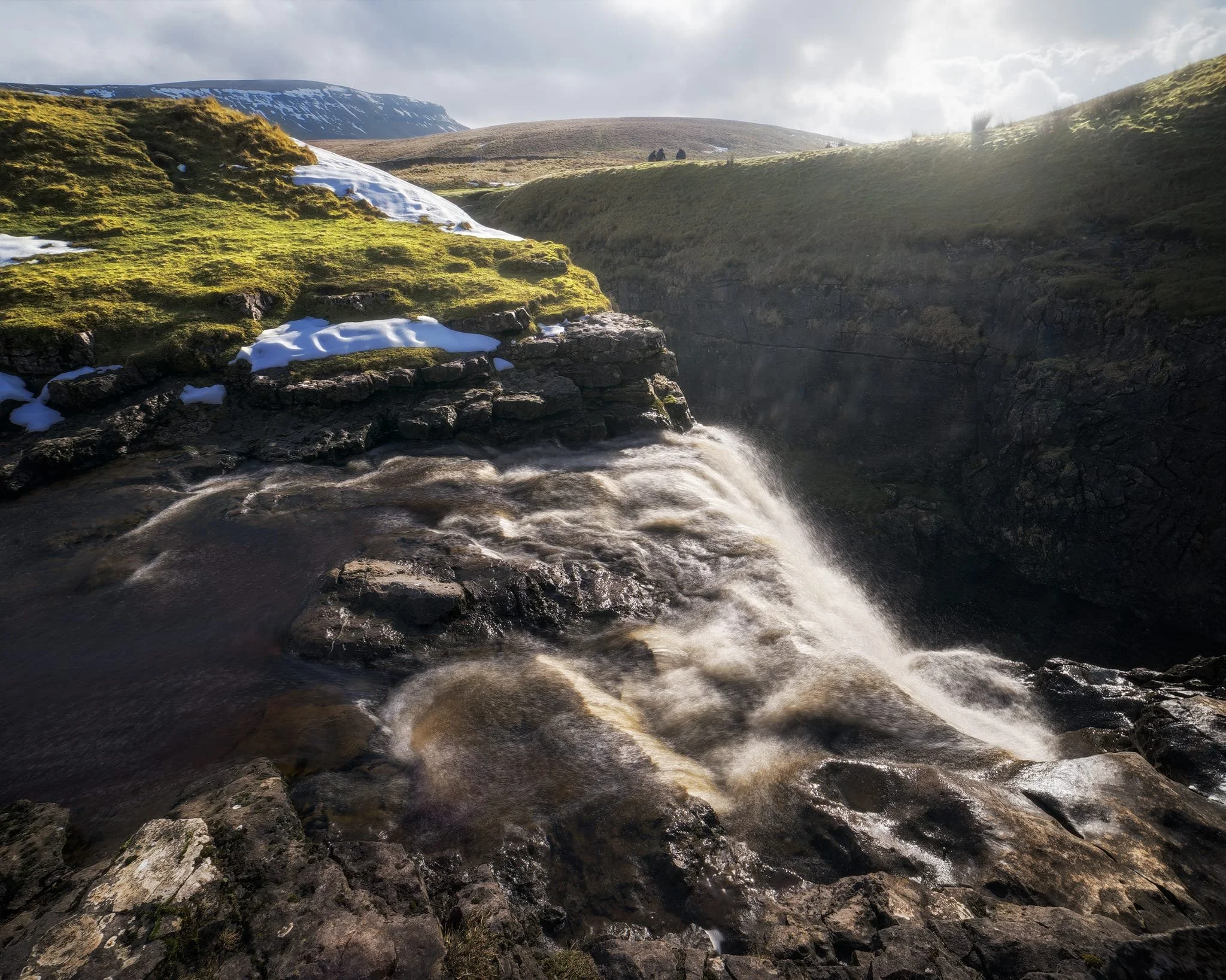
We clambered as close to the waterfall as possible as it crashed over the edge into Hull Pot. As I had no tripod, I shot this with my ultra-wide 14mm at f/22, taking multiple exposures of the same scene. In post, I then averaged the exposures together that gave me that long exposure effect on the water.
Looking up Hull Pot Beck and its many cascades. By the normal way of things, this beck is dry as it usually disappears into the maze of caves beneath Pen-y-Ghent before it reaches Hull Pot. With all the rain and snow we’ve had, the beck was able to complete its route, crashing 60ft down into Hull Pot and re-emerging at the surface nearer Horton-in-Ribblesdale.
A different view of Hull Pot from its eastern end. Two boulders balance precariously on the lip of the pot.
At around 450 m/1,476 ft above sea level, a few snow patches have lingered around the edges of Hull Pot, allowing for some interesting compositional leading lines.
A particularly clean snow patch nearer the falls gives me an idea for a composition involving Pen-y-Ghent in the distance. Fellow hikers milling about the edge of Hull Pot give you a sense of scale of this place.
Heading back down to the village, signs were clear that the best of the day’s light were done as the storm clouds rolled in. We were thankful to get what we did, though.
Did you enjoy these photos?
Dovedale, Peak District, Autumn
From the Dark Peak to the White.
From the Dark Peak to the White.
In my last post, I talked about how the Peak District can be broadly split into two areas: the Dark Peak and White Peak. They reflect the predominant underlying geology: gritstone for the Dark Peak, and limestone for the White Peak.
After exploring the Dark Peak’s Froggatt and Curbar Edges, it was time to navigate the deep valley of Dovedale in the White Peak.
Dovedale is a particularly famous area in the Peak District—and the UK in general—seeing around 1 million tourists a year. It features stepping stones, rocky spires, craggy hills, and caves.
We elected to hike the full route, south to north, from the main car park to Milldale and back. In my view, Dovedale exceeded spectations.
All photos shot on my Sony α7ii using my Sony FE 28–70mm f3.5–5.6 OSS zoom and Rokinon 14mm f2.8 ED AS IF UMC prime lenses. RAWs were developed and edited in Lightroom for iPad, and finalised with the help of Darkroom for iPad.
Dovedale, Peak District, Autumn by Ian Cylkowski is licensed under CC BY-NC-SA 4.0![]()
![]()
![]()
![]()
Upon entering the valley, it became immediately apparent how steep and craggy the valley sides were.
Arguably Dovedale’s most recognisable landmark, the stepping stones. Used to cross the River Dove and continue up the valley. This photo was unfortunately timed. I waited for this composition, looking for someone to cross the river to provide context for the photo. Instead, I managed to snap the moment just before this poor gentleman fell into the river. He wasn’t hurt, thankfully, and was quickly helped out.
Further into Dovedale and glorious autumn colours revealed their hues in the woods of the valley.
The first tastes of what was to come. This limestone spire is part of the Tissington Spires that line the eastern side of the valley past Lover’s Leap.
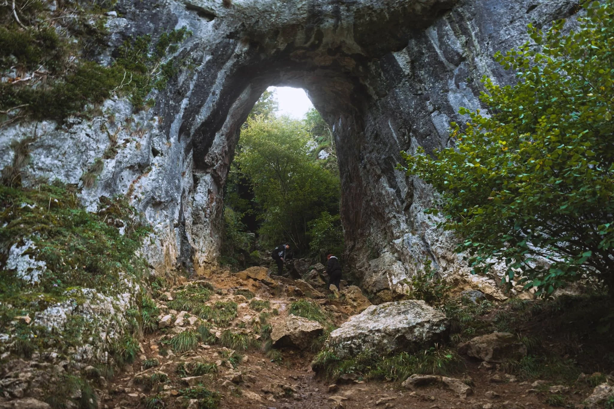
We paid particular attention to finding this spot, and were not disappointed. Beyond Tissington Spires an inconspicuous trail branches off the main valley footpath. It climbs up the steep valley side, revealing this monumental scene: a limestone archway, beyond which is Reynard’s Cave. A stupendous scene.
Beyond Raynard’s Cave, Dovedale narrows and deepens further into an area known as the Straits. Passage is possible only via a raised boarded trail. Once off the boards, we noticed a small cave with a clear and tempting stream trickling out of it.
The most accessible, and driest, caves in Dovedale are the Dove Holes, pictured here high above the trail.
Another solitary limestone spire pierces the sky above the woods.
The Dove Holes caves. They were formed during the last two ice ages by glacial water erosion. The caves became dry as the meltwater and river cut deeper into the gorge.
I got closer to the caves with my ultra-wide angle lens attached. It’s easy to imagine various ancient peoples and cultures have used these caves as shelter and storage.
The other, bigger, cave of Dove Holes, separated by a spire.
At Milldale, we paused for lunch and took the opportunity to wander around this bonny little village.
Milldale probably got its name from the corn mill that once stood on the River Dove here. Nowadays, it’s a sleepy little village with old stone cottages. Proper lovely.
After lunch it was time to take the return trip back down south the valley. This scene very much put me in mind of something like Yosemite.
One of the more famous spires in Dovedale can be seen on the right: Ilam Rock. Facing it is Pickering Tor. Ilam Rock rises 80 ft high from the valley floor, and is an impressive sight from any angle.
Near the Tissington Spires, Jacob’s Ladder rises above the woodland and catches the late afternoon light.
From below, the Tissington Spires are an imposing sight. Here they catch the golden afternoon light as the valley floor recedes into cold shadow.
Nearing the stepping stones once again, Dovedale’s most famous peak—Thorpe Cloud—comes into view. Here I took two exposures: one with my thumb covering the sun and one unobstructed. Blocking the sun with my thumb allowed me to blend the exposures with minimal lens flare.
Thorpe Cloud is an impressive pyramidal peak from across the River Dove.
One final look back into Dovedale before exiting for the day. An absolutely spectacular place.
Did you enjoy these photos?
Hull Pot, Yorkshire Dales, Summer
There’s something awe-inspiring yet slightly unnerving about a giant hole in the ground.
There’s something awe-inspiring yet slightly unnerving about a giant hole in the ground.
The Yorkshire Dales is known for many things: beautiful waterfalls everywhere, isolated peaks, perfectly sculpted valleys… and also, caves. It’s home to some of the most extensive cave systems in the UK.
This is largely because of the underlying geology. Most of the Yorkshire Dales features Carboniferous limestone, which is soluble in weakly acidic water, such as rain. As a result, millennia of glacial action and weather erosion has given rise to a karst landscape dotted with deep potholes that lead down into a myriad of cave systems. It’s in the Yorkshire Dales that the UK’s longest cave system—and the world’s 13th longest—can be found: the Three Counties system, which is 53 miles long.
Down the western flank of Pen-y-Ghent, one of the Three Peaks of the Yorkshire Dales, one can find a 60ft deep chasm in the earth called Hull Pot. It is the remnant of a cave with a collapsed roof.
It is extremely impressive.
All photos taken on my Fujifilm X-T2 using my Vivitar “Series 1” 28–105mm f2.8–f3.8 zoom lens and a Laowa 9mm f/2.8 prime ultra-wide. RAW files were converted with Capture One for iPad, developed in RNI Films, and finished in Affinity Photo for iPad.
Hull Pot, Yorkshire Dales, Summer by Ian Cylkowski is licensed under CC BY-NC-SA 4.0![]()
![]()
![]()
![]()
The route to Hull Pot is simple enough and starts at the small village of Horton in Ribblesdale. Heading up the Pennine Bridleway, views quickly open up looking back to Ingleborough.
The characteristic barns of the Yorkshire Dales, some in a better condition than others.
The first glimpse of Pen-y-Ghent’s unmistakeable shape comes into view.
The clouds above us were ridiculously pretty, ranging from low-level fluffy clouds, high-level streaky ones and even some lenticular in between.
A dilapidated barn connecting to the drystone wall provides a perfect Yorkshire Dales subject for this gorgeous composition.
Though not busy, there were still plenty of people on the trail. Mostly heading to, and from, Pen-y-Ghent.
It’s always important to check the view behind you occasionally. Beyond the winding drystone walls, Smearsett Scar rises above the karst landscape.
As the morning progresses the clouds burn off, revealing the flat-topped Ingleborough on the left with Simon Fell on the right.
Painterly clouds like a mad genius’ brush strokes decorate the skies as we advance along the bridleway.
Around Horton Scar the path averages out in height at around the 400m asl mark. The light picked out the folds and ruffles in the landscape.
Fellow hikers make their way back down to the valley bottom after climbing Pen-y-Ghent.
The western aspect of Pen-y-Ghent with its famous brow and “nose”. I enjoyed making this Z in the landscape using the drystone wall as it climbs up Horton Scar.
A female Northern Wheatear (Oenanthe oenanthe), seemingly unfazed by our presence and appreciation.
Another extinct waterfall, located at the head of Horton Scar. There are many of these in the Yorkshire Dales. The rivers that feed these waterfalls usually break down the limestone riverbeds and valleys they create before heading underground, leaving the waterfall to dry up.
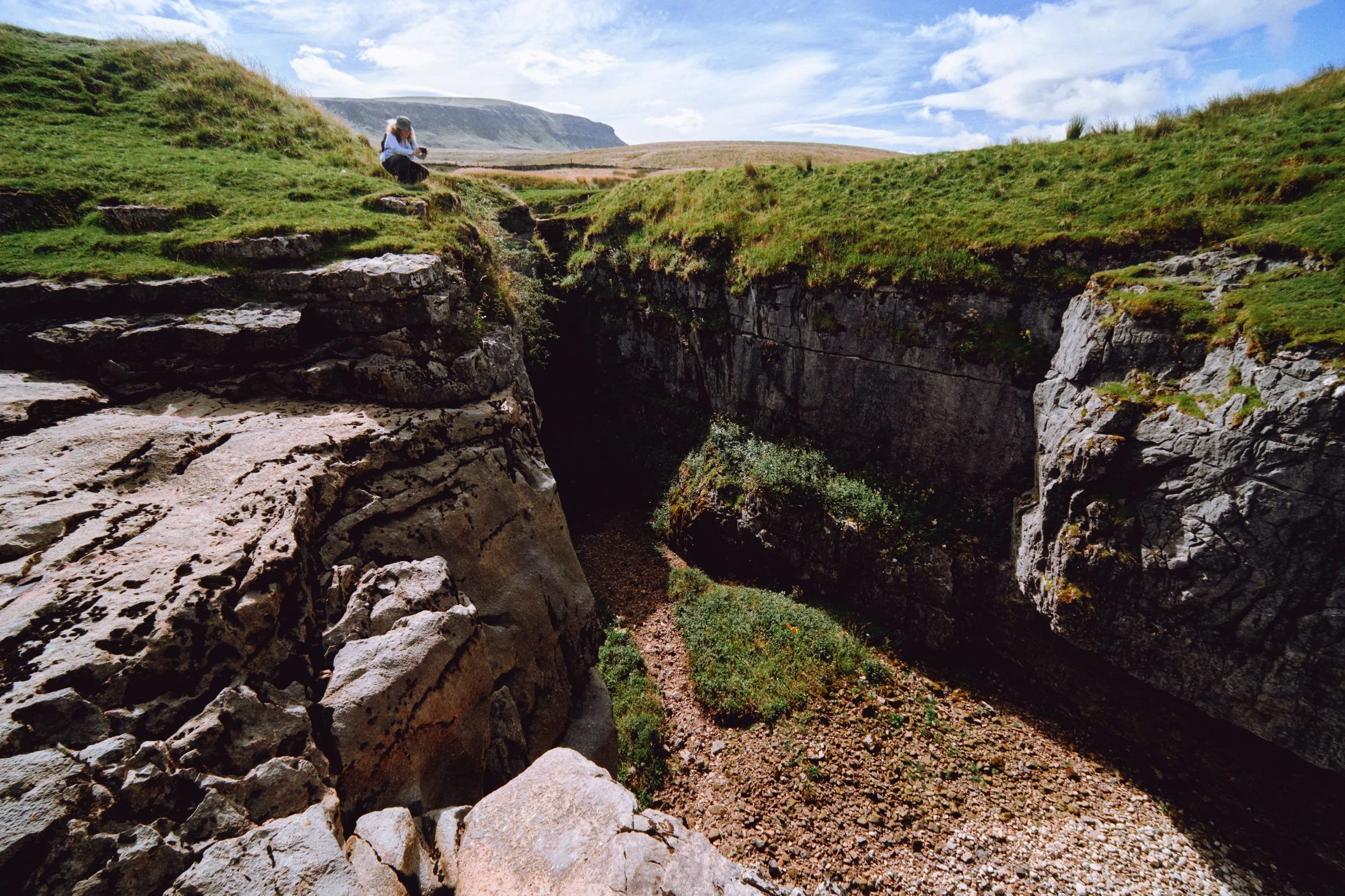
We arrive at Hull Pot. With my 9mm ultra-wide lens equipped, I shot this expansive view of the 60ft chasm from near its eastern edge. From the edge you can actually hear the rushing of a waterfall.
This is Hull Pot Beck. In times gone this river would flow over the lip of Hull Pot, crashing down as a large waterfall. These days it’s mostly dry except during times of heavy rainfall, as the water now sinks underground further up the river.
Lisabet and I played around the edge of the “waterfall” and Hull Pot, finding compositions. In the distance is Pen-y-Ghent, always watching.
Weird to think that this composition would, in ancient times, mean standing at the precipice of a large roaring waterfall.
As we move into late summer, beautiful pink and magenta heather starts to bloom.
My favourite composition in the area: the chasm of Hull Pot with Pen-y-Ghent rising high above.
The 50ft+ sheer walls of Hull Pot. In the darkness there is actually a waterfall that rushes out of the caves at the bottom of this chasm.
After a spot of lunch perched on the lip of Hull Pot’s eastern end, I snap one last photo of the chasm before heading back.
The Pennine Bridleway continues up towards Pen-y-Ghent, the common route to summit the fell.
The atmosphere was wonderfully clear. From above Horton Scar we could see all the way to Pendle Hill in Lancashire, here towards the left of the photo.
The characteristic “rakes” that line the shoulders of Pen-y-Ghent were revealed after a frightful storm in the 19th century washed away a lot of top soil from the fell.
Nearly back at Horton in Ribblesdale. What a beautiful day.
Did you like these photos?
Bullpot, Yorkshire Dales, Summer
The heatwave has finally ended.
The heatwave has finally ended.
After a week of temperatures pushing 30°C consistently with barely any air movement, today was looking a more comfortable 23°C with some wind.
About a month ago we embarked on one of our favourite local-ish walks, Barbondale in the Yorkshire Dales. On that occasion I was somewhat distracted by the sheer number of deer flies biting chunks out of me. Part of the Barbondale hike we did involved clambering over into Bullpot. We resolved to return to Bullpot for a deeper exploration of the area’s famous pot holes, gills, and caves, particularly Ease Gill Kirk.
After a lazy start, today was that day.
The dry ravines around the junction between Ease Gill and Leck Beck display some wonderful geology. Like a lot of the Yorkshire Dales, the gills here are largely made of limestone, which is porous and soluble in water. Limestone landscapes lend themselves to lots of waterfalls and cave systems, and the Ease Gill Cavern System is the longest and most complex cave system in Britain. As a result of the areas various potholes and caves, the area around Ease Gill Kirk is largely dry and full of “extinct” waterfalls, ready for exploration.
Which we duly did as best we could.
All photos taken on my Fujifilm X-T2 using my three prime lenses: a Samyang 35mm f/1.2, a Laowa 9mm f/2.8, and an adapted Pentax 55mm f/2.0 lens. Images made 80% in-camera using a customised Velvia film simulation, with minor edits afterwards in Lightroom and Affinity Photo.
The way to Ease Gill Kirk, after passing Bullpot Farm. The old farmhouse now serves as the base for the Red Rose Cave & Pothole Club.
The ruins of two lime kilns provide a hint as to the industrial heritage of this area.
The Bullpot valley features lots of dry stone walls that expertly trace the steep curves of the dale.
Layers and layers.
Our first sighting of the dry Ease Gill Kirk. Now to clamber down and explore…
We followed the dry river bed east up Ease Gill to find our first “waterfall”. The gill is largely dry now—save for periods of heavy rain—as the limestone geology of the area is water soluble. This means that the water that once carved out this river and waterfall now disappears further up the gill into a deep cave system, many miles below.
Nature is a fantastic sculptor. It was amazing to see the curves and forms created in the rock face by the waterfall that used to flow over here.
A stagnant pool is all that remains of this extinct waterfall.
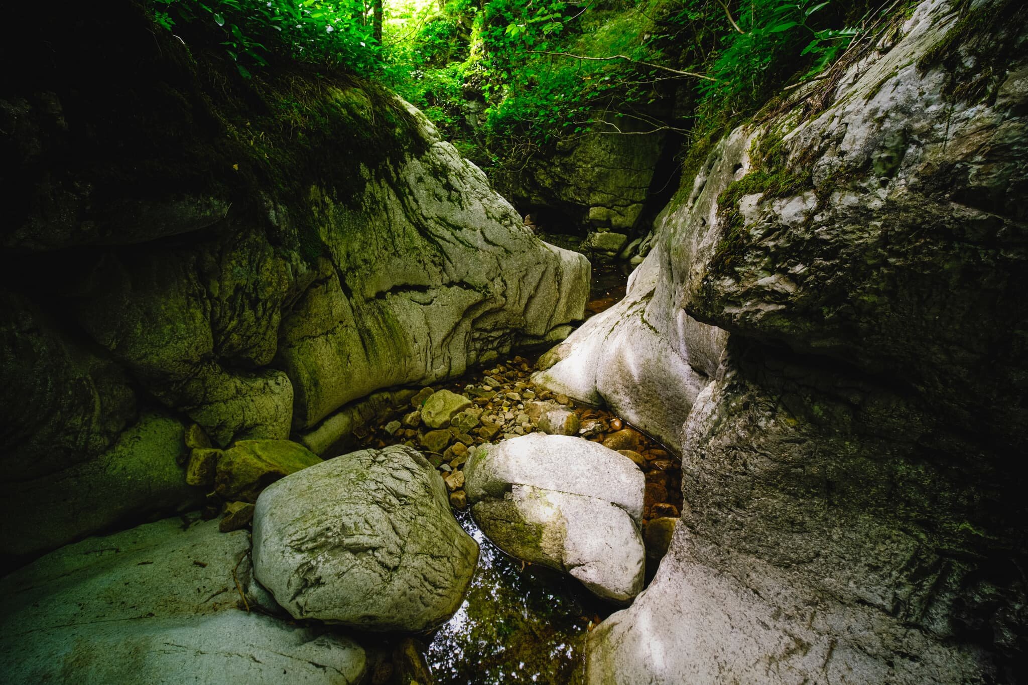
We exited back out of Ease Gill and made our way south to Ease Gill Kirk, following the dry river.
Lisabet and I scrambled down the gorge created by Ease Gill to capture this world of twists and turns. I’ve no doubt that with a good pair of wellies on, and a more adventurous spirit, you could follow this largely dry gorge a good distance. For now, this will do.
The ruins of Hellot Scales Barn, which serves now as a signpost of sorts for locating Ease Gill Kirk.
On the way back to Bullpot Farm I, of course, had to snap some compositions of the brilliant dry stone walls here.
Just follow the wall all the way back to Bullpot Farm. I suspect in wetter months the path between Bullpot Farm and Ease Gill Kirk would be consistently boggy.
The area near Bullpot Farm is home to lots of shake holes, not to mention one of the main entrances into the Ease Gill Cave System, ominously called “Bull Pot of the Witches”.
I saw it, lined it up, and took a photo of it.
One final shot of the wall of fells above Barbondale known as Calf Top.

Hull Pot, Yorkshire Dales, England
After two weeks of illness kicking both me and Lisabet hard in the dick, it was nice to have a weekend where we were both well and the weather looked good.
After two weeks of illness kicking both me and Lisabet hard in the dick, it was nice to have a weekend where we were both well and the weather looked good.
We took full advantage—of a lie in—then made our ways towards Horton-in-Ribblesdale, a small village in the heart of the Yorkshire Dales. It was here that we would take a glorious hike along the Pennine Way towards Hull Pot and Pen-y-ghent.
Hull Pot is essentially the remains of a cave, of which there are many in the Yorkshire Dales, where the “roof” has collapsed, leaving a giant chasm in the surrounding moorland underneath Pen-y-ghent. It’s the largest natural hole in England, measuring 300 ft long, 60 ft wide, and 60 ft deep.
But arguably the main showstopper of the area is Pen-y-ghent (694 m/2,277 ft), the fell that dominates the skyline all around the Ribblesdale valley. It’s an unusual name as it sounds very Welsh; that’s because the name survives from ancient Cumbric, which is related to Welsh. Pen means “top” or “head” and y is usually the definite article. Ghent could mean “edge” or “border”, giving the fell’s name as “Hill on the border”.
Shots taken on a Fujifilm X-T2 using the Fujinon XC 16-50mm f/3.5-5.6 OIS lens. Also an extra one or two with my Google Pixel 3XL using a Moment 18mm v2 wide lens.