
Stanley Ghyll Force, Lake District, Spring
After a sobering return from a beautiful week in the Highlands, it was time for a beautiful little jaunt in Eskdale.
After a sobering return from a beautiful week in the Highlands, it was time for a beautiful little jaunt in Eskdale.
I was also due to hang out with me Dad again. After arriving at Dad’s, he suggested checking out Stanley Ghyll Force, one of the Lake District’s largest waterfalls. I were game for that!
Stanley Ghyll Force is located in Eskdale, a gorgeous valley in the southwestern corner of the Lake District. The last―and only―time I visited Stanley Ghyll Force was back in 2017. I know this because I shot the waterfall with a Sigma dp0.
Back then, I was all on me own attempting to navigate a tricky gorge. However, on that occasion, I was able to get right to the bottom of the falls for some cracking.
A lot has changed in the intervening 5-6 years. For a start, you can’t get to the bottom of the falls anymore. The path has eroded and collapsed to the point that it’s too dangerous. Instead, the Lake District National Park have created an alternative route that scales up the sides of the gorge so that you can get above the falls. In addition, they’ve also cut back hectares of invasive rhododendron and constructed a fantastic viewing station above the gorge.
We enjoyed some fantastic light, and I had a grand day out with me Dad.
All photos taken on my Fujifilm X-T2 using my Vivitar “Series 1” 28‒105mm f2.8‒3.8 zoom, Super Ozeck 80mm‒210mm f4.5 zoom, and Laowa 9mm f2.8 ultra-wide prime lenses. RAWs developed in Capture One for iPad, edited in Affinity Photo 2 for iPad.
Stanley Ghyll Force, Lake District, Spring by Ian Cylkowski is licensed under CC BY-NC-SA 4.0![]()
![]()
![]()
![]()
The gorge that contains Stanley Ghyll Force is wonderfully mossy and vibrant. Here, a pocket of light illuminates a boulder field exposed in the woodland.
We passed a small tributary beck that was catching some wonderful light in the gorge.
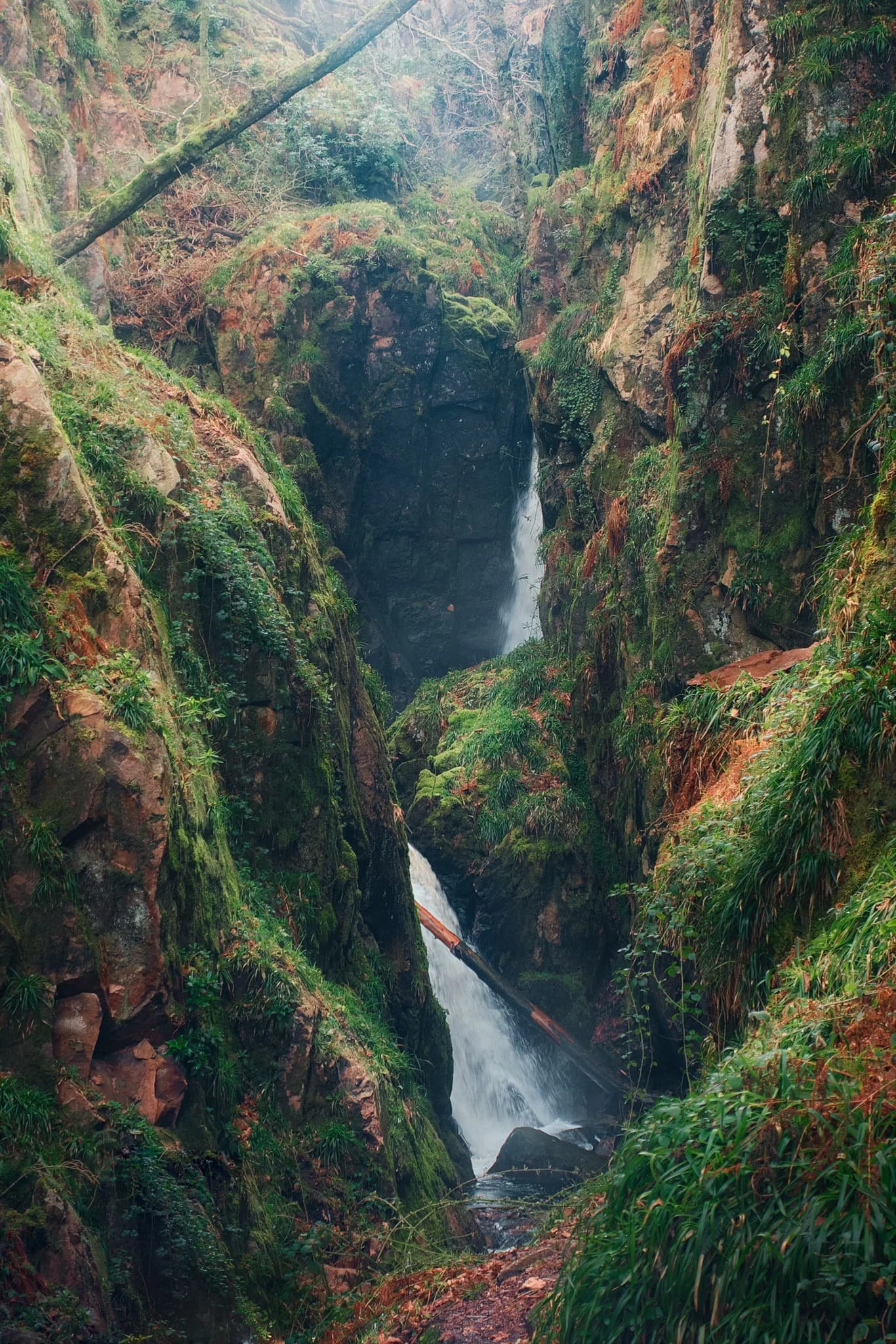
Eventually, the glory of Stanley Ghyll Force came into view. This was as close as we were allowed to get to it. Still some absolutely crackin’ light flooding into the gorge though.
After hiking up the new path made by the National Park, we found the new viewing station to check out the views it offered. And… wow. A sheer 150ft drop pulls your down the gorge and towards Stanley Ghyll Force. What a sight.
We followed the return track back down to the valley. As we did, me and Dad spotted some incredible light playing out on the distant Eskdale fells, and stopped to shoot photos like crazy.
Did you like these photos?

Lingmoor Fell, Lake District, Winter
I’ve been wanting to get into the snowy mountains for a while.
I’ve been wanting to get into the snowy mountains for a while.
As I’d accrued a fairly significant amount of flexi-time at work, I used it to take a mid-week day off and headed into Lake District.
Lingmoor Fell is a small hill I’ve had my eye on for quite some time. It’s only a modest fell, standing at 469 m (1,540 ft) a.s.l., but what it lacks in height it more than makes up with the sensational views it offers. Lingmoor Fell’s isolated position in the Central Lake District—separating Great Langdale from Little Langdale—means some of the finest panoramas in all the Lake District can be found on this small fell.
Though I ultimately didn’t feel confident or skilled enough to properly summit Lingmoor in the current sub-zero temperatures, I nevertheless managed ascending the fell’s shoulders and obtained some absolutely crackin’ photos.
All photos taken on my Fujifilm X-T2 using my Vivitar “Series 1” 28–105mm f2.8–3.8 zoom and Laowa 9mm f2.8 prime lenses. Shot using the camera’s Classic Chrome film simulation, edited in Capture One for iPad, and finished in Affinity Photo 2 for iPad.
Lingmoor Fell, Lake District, Winter by Ian Cylkowski is licensed under CC BY-NC-SA 4.0![]()
![]()
![]()
![]()
The start of the walk ascends the fellside from Elterwater village, through winding country roads that have become a winter wonderland, totally frozen.
After navigating the country roads and Sawrey’s Wood, you soon emerge onto the open fellside with wonderful views across Great Langdale towards the Grasmere fells.
The tiny village of Chapel Stile in the Great Langdale valley, with the rusty, craggy fells looming high above in the morning winter light.
Lots of quarrying has happened around the slopes of Lingmoor Fell, and continues to this day (though on a much smaller scale). I sneaked into this disused quarry largely for the icicles.
The old miner’s track provided a clear way up the fell. The day was crisp and bitingly cold, with the moon clear above. My destination was the peak illuminated by the sun.
It didn’t take long before I came across the Lake District’s famous sheep, Herdwicks. The path continued up to the left.
Herdwicks are such posers. They know they’re pretty.
Up on the shoulder of Lingmoor Fell the views instantly open up in all directions. Here the rusty bracken and crags of Lingmoor Fell provide a nice contrast to the distant wintery views of Ambleside and the Kentmere fells.
Over the wall, towards Grasmere, Fairfield can now clearly be seen with a dusting of frost on its flat summit.
Herdwicks graze upon the scant vegetation of a crag. The ridge of Lingmoor Fell is totally lined with this drystone wall, making it easy to navigate along the fell.
I turned away from summiting Lingmoor Fell as the path quickly become a long sheet of ice. Instead, I skirted around its shoulder towards some disused quarries. Here, Wetherlam and Swirl How revealed their wintery magnificence to me.
I took a water break near this crag and started crawling around it with my ultra-wide angle lens, looking for compositions involving those beautiful wintery mountains.
This one’s probably the best of the bunch.
Heading back down the old miner’s track, I catch a glimpse of one the axe-like peaks of the Langdale Pikes, and line up a composition.
Not a bad place for a cottage, eh?
Back on the winding country roads towards Elterwater village.
What a crackin’ day.
Did you like these photos?

Cunswick Scar, Cumbria, Winter
The first snow of the season has arrived.
The first snow of the season has arrived.
Fortunately—living where I do—there are plenty of quick routes one can take from the town centre to ascend some nearby hills and check out the expansive wintery views.
The Lake District fells? Howgills? Barbondale fells?
They did not disappoint.
Atmosphere was clean and clear. You could almost reach out and touch the mountains.
All photos taken on my Fujifilm X-T2 using my Vivitar “Series 1” 28–105mm f2.8–3.8 zoom lens. Shot using the Classic Chrome film simulation, edited in Capture One for iPad and finalised in Affinity Photo 2 for iPad.
Cunswick Scar, Cumbria, Winter by Ian Cylkowski is licensed under CC BY-NC-SA 4.0![]()
![]()
![]()
![]()
We’ve had a week of sub-zero temperatures, resulting in snow. It’s also largely been dry and completely clear, so it was no wonder lots of other people (and their furry friends) were out and about enjoying the views.
My lovely Lisabet, enjoying the beautiful light and atmosphere of the Kentmere fells.
For others, the outdoors are best enjoyed whilst exercising.
Up on the summit of Cunswick Scar, the Coniston Fells positively glow with snow.
Zooming out to capture the entire expanse of the Lake District fells. Not all of it covered in snow as of yet.
However, looking towards the Howgills… wow. Clouds washing over them like a waterfall. Glorious light, highlighting the beautiful contours of the Howgills.
Navigating the steep path around Helsfell Nab towards these barns was… tricky. A popular trail means compacted snow that became frozen over and over again.
Only about 1pm at this point, but already the sun was setting and drenching the land in warm winter light.
Back down to the beautiful Auld Grey Town.
Did you enjoy these photos?

Clapham & Trow Gill, Yorkshire Dales, Winter
The seasons progress and the weather is changing.
The seasons progress and the weather is changing.
After a month of near-constant rain interspersed with heavy fog, a high-pressure system is moving in and bringing with it clearer skies and lower temperatures.
Winter has arrived.
On Saturday we were greeted with clear skies and a biting wind. We ventured into the Yorkshire Dales—Clapham, to be precise—for a hike up towards and above Trow Gill. We would then scramble through the gill to get to the high moorland above for extensive panoramic views.
It were a crackin’ day for it.
All photos taken on my Fujifilm X-T2 using my Vivitar “Series 1” 28–105mm f2.8–3.8 zoom and Laowa 9mm f2.8 prime lenses. Developed in Capture One with the “Classic Chrome” Fujfilm simulation, finalised in Affinity Photo 2 for iPad,
Clapham & Trow Gill, Yorkshire Dales, Winter by Ian Cylkowski is licensed under CC BY-NC-SA 4.0![]()
![]()
![]()
![]()
It’d been a long time since I visited Clapham. In fact, I can recall the last time because I was still shooting with a Nikon D7000 that was nearly permanently attached to a tripod. This means the last time I was at Clapham was around 2016. Wow.
Here is something I do not remember from our last visit: a friggin’ waterfall! Turns out there’s been a lot of conservation work in recent years, some of which involved clearing the riverside bank here of snowberries, which was obscuring views of this waterfall.
The last of the year’s autumn colours in beautiful winter light.
Clapham Falls is a man-made waterfall, constructed as a three-tier drop underneath a bridge in the early 19th century by the Farrer family. They’ve long had established ties to the village and the 19th century saw a lot of landscaping and remodelling of the village.
This is something I wasn’t expecting to see in winter: flowering plants! I think this might be Mahonia japonica, which is apparently native to Taiwan. It flowers in winter through to spring.
After working our way up and through Clapdale Wood and past the famous Ingleborough Show Cave we finally arrived at the entrance to Trow Gill.
Trow Gill is an immense ravine with 200ft high cliff walls. It was once the site of a massive waterfall, much like Troller’s Gill near Appletreewick.
We scrambled up the gill to access the high moorland above. From here, looking back down, I start to imagine what the waterfall would’ve looked like and the forces involved in sculpting this ravine. Immense.
The beck which once flowed through here as a raging waterfall begins life on the eastern slopes of Ingleborough. At some point in the distant past the beck no longer reached this ravine, instead falling underground near Ingleborough down a giant cavern now known as Gaping Gill. It is technically England’s single biggest drop waterfall, even though it falls underground.
Scrambling up and out of the gill, the land begins to open up and we can start to glimpse the eastern aspect of Ingleborough.
Above us, to the north, a limestone scar is drenched in winter light whilst the sky is ominously dark and cold.
The more unfamiliar view of Ingleborough. To the left is Little Ingleborough, with the main fell to the right. Though the trail continues on towards the fells, we decided to loop back and reconnect with the Pennine Bridleway.
Zooming right in on Little Ingleborough. You can just make out the tiny figures following the trail up the fell.
Up on the moorlands above Clapham, the views massively open up. Beyond Thwaite Scar we could make out the distant yet distinct shape of Pendle Hill, all the way in East Lancashire.
Even more impressively, Pen-y-Ghent was clear as a bell and looking spectacular.
The rolling landscape of the Yorkshire Dales, interspersed with karst limestone formations such as limestone pavements, scars, ridges, and of course the distinctive isolated fells.
Back on the Penine Bridleway south to Clapham, Thwaite Scar receives some late afternoon golden light.
Before dropping down to the village, I nab one final composition of Robin Proctor’s Scar—a sheer cliff face—being bathed in golden winter light.
Did you enjoy these photos?

Walla Crag, Lake District, Summer
A 4am start.
A 4am start.
The UK is on the cusp of a record-breaking heatwave, kicking in Sunday evening/Monday morning. Even before the real heatwave arrived, Sunday’s temperatures up here in Cumbria were looking to peak at around 26°C. Not only that, summer in the Lake District is easily its busiest time. So what to do?
Wake up before the sun rises and get to our destination before everyone else.
We decided on revisiting the small Walla Crag above Derwentwater, a new favourite after our first venture in autumn last year. Upon leaving the house we were greeted with something we didn’t expect before a heatwave, but probably should’ve anyway.
Rain.
We pulled up at the parking spot, and thankfully it only took 15 minutes or so for the rain to cease. By about 6:40am we started the walk up to Walla Crag.
Although the rain had cleared, it was still completely overcast even as temperatures quickly rose. The sun was not able to break through. So although light conditions were not the best, the views were still utterly magnificent.
All photos taken on my Fujifilm X-T2 using my Vivitar “Series 1” 28–105mm f2.8–f3.8 zoom lens. Shot using the Classic Chrome film simulation, developed in Capture One for iPad, cleaned up in Affinity Photo for iPad.
Walla Crag, Lake District, Summer by Ian Cylkowski is licensed under CC BY-NC-SA 4.0![]()
![]()
![]()
![]()
Across the fields from the Walla Crag path, Low Rigg looks diminutive against the imposing crag face of Clough Head, part of the Helvellyn range.
As we began the steep ascent up to Walla Crag, the views looking back opened up quickly. Here, Blencathra’s beautiful shape is unmistakeable.
The way up to Walla Crag, a short and sharp ascent.
Once up on the more level part of the fell, a small gate through the drystone wall allows you to take the more exploratory route to Walla Crag’s summit. Near the crag’s cliff edge, clear panoramas can be enjoyed across Derwentwater to the Grisedale fells.
Back along the cliff edge towards Blencathra, already there is some heather starting to appear. Give it another month or so for it to be in full resplendent bloom.
The smooth multi-peaked profile of Skiddaw, England’s 6th highest peak.
Walla Crag’s cliff face is lush, chock-full of fern, trees, heather, and loads of other flora. Lisabet discovered a small bilberry bush, and helped herself to a couple of the tart berries.
The summit of Walla Crag! Looking back north towards Skiddaw, a dominant presence on the Keswick skyline.
Derwentwater looks dry, with a couple of new islands becoming exposed as the water level drops.
One final composition from the summit, this time featuring Blencathra’s curved forms.
Walking towards the Jaws of Borrowdale.
Probably my favourite composition of the day. The drystone wall keeps livestock out of the Walla Crag area, allowing flora to flourish. In the distance is Derwentwater’s southern tip with the Borrowdale fells high above.
The other side of the same wall, featuring more of the Catbells ridge.
On the way back down the fell, I couldn’t resist revisiting this composition.
Pretty happy with how this shot of a family of fell ponies came out.
Did you like these photos?
Scout Scar, New Year’s Day, Lake District, Winter
Happy New Year everyone! Here’s to a joyous and—hopefully—more globally positive 2022.
Happy New Year everyone! Here’s to a joyous and—hopefully—more globally positive 2022.
The weather has been… weird. In fact, the UK set a new temperature record for New Year’s Eve, reaching as high as 16.5ºC. That is uncharacteristically warm. Temperatures maintained their elevated levels on New Year’s Day, too, but high winds also arrived. After a decent lie in, Lisabet and I decided on a local favourite to enjoy the first day of the new year: Scout Scar.
The last time we went up Scout Scar was almost exactly a month ago, and conditions could not have been more different. For New Year’s Day we took the time-honoured route up Captain French Lane and onto Brigsteer Road, following that all the way to the back of Scout Scar. Then, it’s a simple exercise of following the trail up the gentle slope of Scout Scar all the way until you reach it’s precipitous drop down to the Lyth Valley.
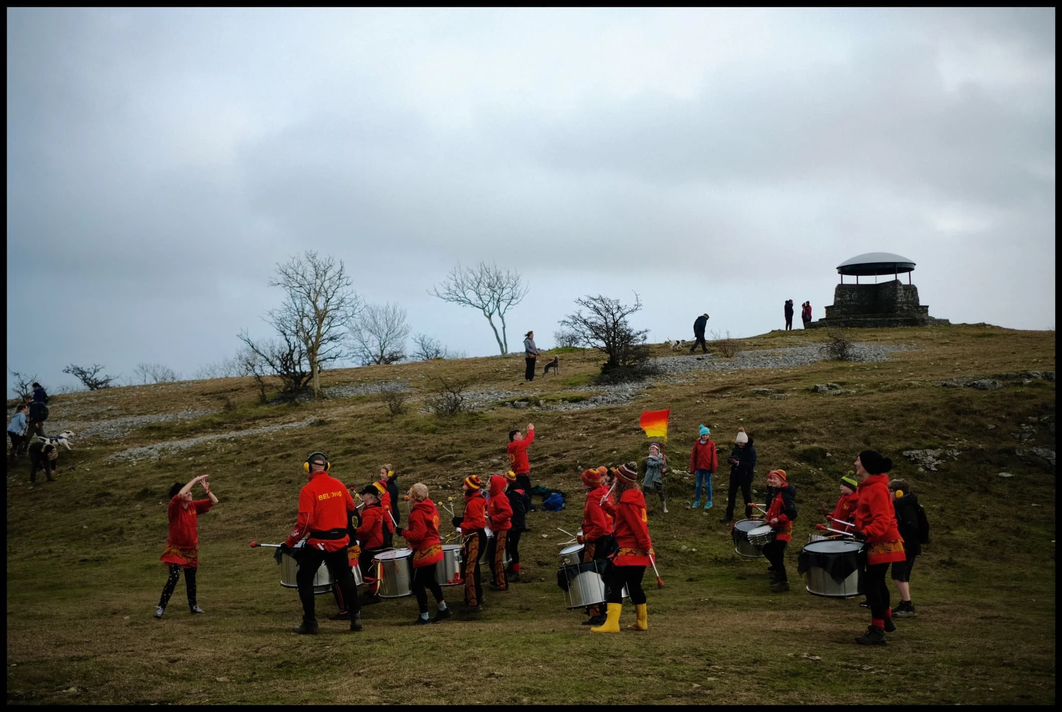
The wind was roaring all around us and views were obscured by haze and low cloud covering the Lake District fells. However, the sun was trying its hardest to burst out in between the rushing clouds. There were other sounds that were less familiar as we approached the summit… more rhythmical, and human. Turns out that Drum Nation Kendal had arrived at the summit for a joyous New Year’s Day drum performance on the fell.
Unexpected? Absolutely. But very awesome.
All photos taken on my Fujifilm X-T2 using two of my prime lenses: a Fujinon 23mm f/2.0 and an adapted Pentax SMC 55mm f/2.0. All images made in-camera using a customised Classic Chrome recipe, with finalisations made in Apple Photos, Pixelmator, and Darkroom.
Heading up one of the steeper roads in Kendal, Captain French Lane.
Crossing over the A591 via Brigsteer Road, cars struggling to drive straight in the powerful crosswinds.
Looking back to Kendal, and you barely make out the slopes of Benson Knott, Kendal’s most prominent fell.
The Scout Scar landscape is one of limestone and sparse clusters of small trees.
Plenty of other folk were heading up Scout Scar for a New Year’s Day yomp, despite the roaring wind.
As we crested onto the plateau of Scout Scar, it became clear there was an immense light show occurring over the Lyth Valley and the Kent Estuary.
My lovely Lisabet, fighting the storm near the cliff edge at Hodgson’s Leap to nab some crackin’ light.
The swirling clouds, full of moisture, suffused the sunlight, and drenched the winter limestone landscape in golden light.
Away from the sun, the view north along Hodgson’s Leap to the “mushroom” on the summit of Scout Scar is always a good ‘un.
The sun catches the cliffs of Scout Scar briefly, whilst the Lyth Valley and the the Lakeland Fells remain shrouded in dark foreboding clouds.
We work our way north along the cliffs of Scout Scar, taking in whatever views we could find, and generally enjoying the dramatic conditions.
It’s a long way down…
A reminder of what was happening behind us. A lot of the Lyth Valley was still flooded after recent downpours.
Our ears prick up at a more unfamiliar sound near the Scout Scar summit. Was that… drumming?
Why yes, yes it is!
Drum Nation Kendal, the epitome of fun, competing with the wind on volume.
Everyone was having so much fun.
Gathering round for the finale.
One last look at the spectacular light show over the Lyth Valley and Kent Estuary.
The legacy of Postman Pat in Kendal. Did you know?