Oronsay, Isle of Skye, Scotland, Spring
We’ve only been to the tiny isle of Oronsay once before.
We’ve only been to the tiny isle of Oronsay once before.
This was back in autumn 2020, before the 2nd pandemic lockdown happened.
Conditions on that occasion were cloudy, flat, and grey. But still, the scenery and views were stunning and we vowed to return again.
And so we did, this time with bright spring skies. A world of difference!
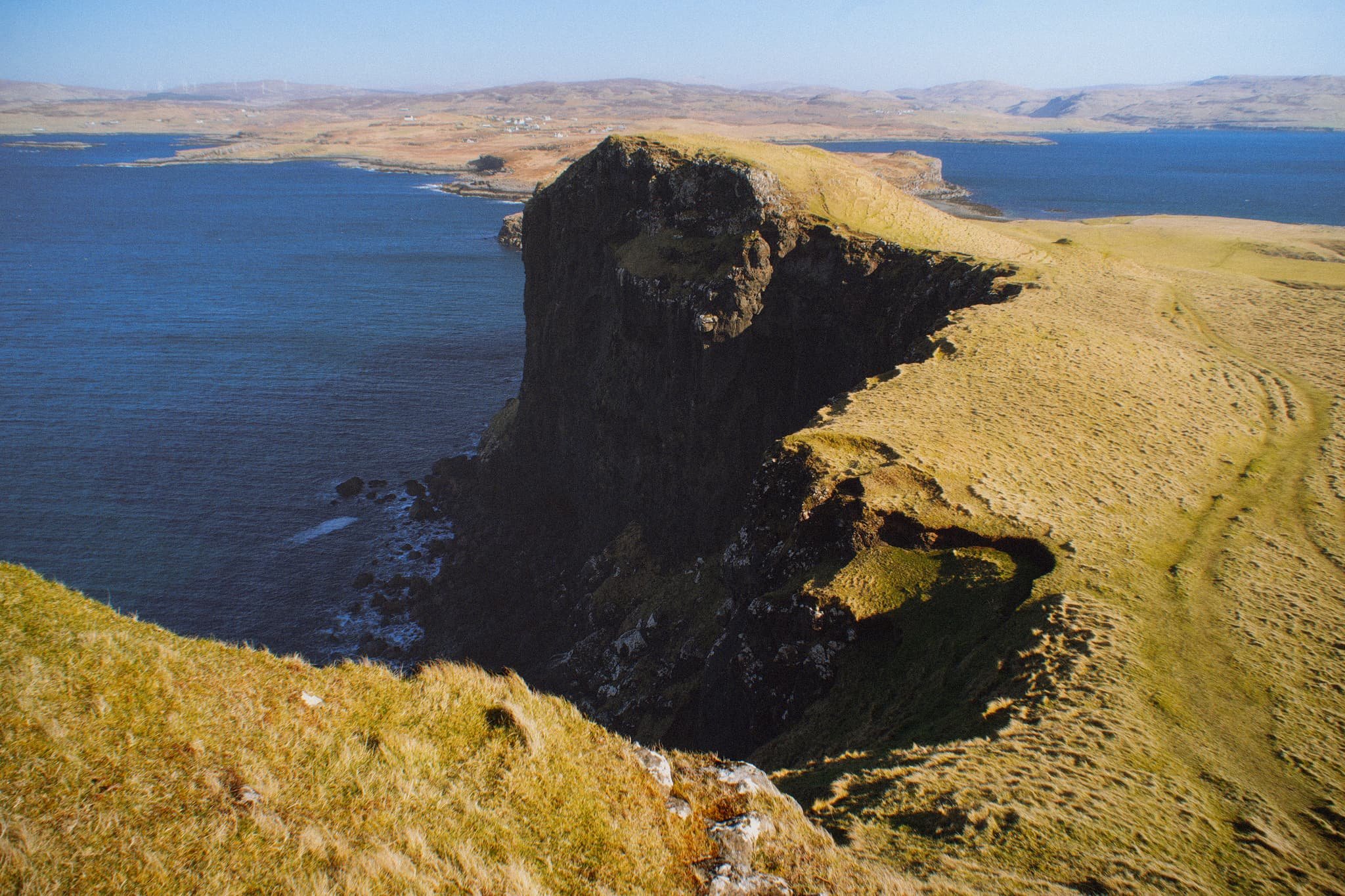
Oronsay can be found in Loch Bracadale, along with lots of other little islands, sandwiched in between the Duirinish and Minginish peninsulas. It’s possible to access Oronsay on foot via a tidal causeway consisting of ankle-breaking fist-sized rocks.
Though only 44 acres in size, it features cliffs 240 ft high, which means it offers incredible views to either the cliffs and hills of the Duirinish peninsula, or the cliffs and Cuillins of the Minginish peninsula.
We didn’t see another soul.
All photos taken on my Sony α7ii using my Pentax SMC 28mm F3.5 prime and Vivitar “Series 1” 70–210mm f2.8–4.0 zoom lenses. RAWs developed in Lightroom using RNI Films’ Kodachrome film profiles, edited and finalised in Photoshop.
Oronsay, Isle of Skye, Scotland, Spring by Ian Cylkowski is licensed under CC BY-NC-SA 4.0![]()
![]()
![]()
![]()
From the mainland at Ullinish it’s a simple, if squelchy, walk from the settlement to the coast. The way to Oronsay then becomes clear; at low tide, the sea is parted by a causeway of boulders and rocks.
Once on the island it’s simple enough to navigate your way towards the highest cliffs. Once there, you get stunning views like this. Zoomed in, the island of Wiay is clear and you can even make out the cliffs and sea stacks of MacLeod’s Maidens.
Looking further east, the eastern end of Wiay gives way to the two distinctive flat-topped hills on the Duirinish peninsula, known as MacLeod’s Tables. The one on the left―MacLeod’s Table South or Healabhal Bheag―is 489 m/1,604 ft. The one on the right―MacLeod’s Table North or Healabhal Mhòr―is 469 m/1,538 ft.
From Oronsay’s tallest cliff, the view northeast down the island and across the loch all the way to Skye proper is just stunning.
Looking back at the tallest cliff, it’s contrasty shape and shadow is used to frame the distant island of Wiay and Duirinish cliffs.
My little Lisabet hiking her way up to the next cliff, whilst I shuffled as close as I dared to the precipitous edge for this monstrous view.
A simple leading line of Oronsay’s cliff edges, all the way back to Ullinish and the moorlands of Skye.
Returning to the lowest part of Oronsay, I venture around its more boggy eastern area for a view back to the craggy cliffs, again using the harsh light and shadow to aid in a leading line composition.
Did you enjoy these photos?

Portree, Isle of Skye, Scotland, Spring
For our 1st full day in Skye, we gradually eased ourselves in.
For our 1st full day in Skye, we gradually eased ourselves in.
Driving 7–8 hours can take it out of you.
So, with pleasing light conditions, we aimed straight for arguably the island’s main settlement, Portree. There’s a fairly well-known hike one can do from Portree, known as the Scorrybreac circuit. You head northeast out of town, take the coastal path below the cliffs of Ben Chracaig, navigate around the corner at Sgeir Mhòe, and follow the coastline towards Toravaig, with magnificent views down the Sound of Raasay and the cliffs of Sìthean a’ Bhealaich Chumhaing. Then it’s a question of hiking up the sharp ascent to Ben Chracaig and onto the path and road back down to Portree.
The views and light around the walk were stunning. Glamaig of the Red Cuillins was coated in snow and clear as a bell.
All photos taken on my Sony α7ii using my Pentax SMC 28mm F3.5 prime lens and Vivitar “Series 1” 70–210mm f2.8–4.0 zoom lens. RAWs developed in Lightroom, then edited and finalised in Photoshop.
Portree, Isle of Skye, Scotland, Spring by Ian Cylkowski is licensed under CC BY-NC-SA 4.0![]()
![]()
![]()
![]()
Upon our arrival at Portree, and parking up at the main car park, the views down Loch Portree towards the snowy Cuillins were already staggering. I quickly attached my longest lens and went snappy happy as the lighshow was constantly changing.
Our goal was to follow the coastal path below the left hill. But before we could get on that, this scene opened in front of me, putting me in mind of the fjords of Norway. I zoomed all the way to 210mm to get a real tight composition, involving the flanks of Ben Chracaig to the left, the crags of Ben Tianavaig to the right, and the hills of the Isle of Raasay in the middle.
On the trail, the sound of rushing water caught our attention. We quickly nipped off trail and followed the sound, locating this beautiful and totally unexpected waterfall! These unnamed falls belong to the River Chracaig as it tumbles down the hills above.
As we rounded the corner at Sgeir Mhòr, this magnificent view down the coastline to the illuminated cliffs of Sìthean a’ Bhealaich Chumhaing appeared.
We followed the trail further down the coastline until it abruptly turns inland near this area of flat land. The path then zigzags up the steep hillside of Ben Chracaig. Halfway up, lighting conditions changed and I quickly nabbed this dramatic shot.
Away from the cliffs and onto the moorland above Portree, this frankly ridiculous scene revealed itself to us. The Storr, lightly dusted in snow, with a thick and dramatic storm above, whilst the Portree moorlands and this house receive a strong burst of sunlight from behind us.
Back at Portree the light continued to change dramatically, with the clouds lifting above the Cuillins. I zoom in tight on this composition of Portree harbour as the light broke through the clouds enough to highlight the snowy Cuillins.
Did you enjoy these photos?
Holy Island/Ynys Gybi, Anglesey, North Wales, Spring
After getting some delicious mountain action, it was time to head back to the coast.
After getting some delicious mountain action, it was time to head back to the coast.
Anglesey is the largest island in Wales, and the 7th largest in Britain, separated from the North Wales by the narrow Menai Strait.
If you travel across the island all the way to its northwestern tip, you can cross the Cymyran Strait onto a much smaller island called Ynys Gybi, or “Holy Island” in English.
Ynys Gybi features a rocky coastline full of cliffs and rises to 220m/722ft at Holyhead Mountain. Much like Inception, there are an additional two islands off Ynys Gybi: North Stack and South Stack.
Our hiking for the day involved checking out Rhoscolyn Headland, then onwards to revisit the epic South Stack and its lighthouse.
The day was full of low cloud and a dramatic mood.
Photos taken on my Sony a7ii using my Vivitar “Series 1” 28–105mm f2.8–3.8 zoom lens. RAWs developed in Lightroom for iPad, then edited and finalised in Affinity Photo 2 for iPad.
Holy Island/Ynys Gybi, Anglesey, North Wales, Spring by Ian Cylkowski is licensed under CC BY-NC-SA 4.0![]()
![]()
![]()
![]()
Unbeknown to us, Rhoscolyn Head is world-renowned for its fascinating geology. As an amateur “rock nerd” myself, I was delighted with what I found. Here, I found a cliff edge covered in wildflowers, looming over Porth Gwalch.
Fascinating shards of rock like plates of armour line this cliff as a strand of light escapes the thick cloud cover.
Rhoscolyn Head is known for its exposures of the South Stack formation of rocks. These are Cambro-Ordovician metasedimentary rocks, which demonstrate unusual foldings at certain places, such as here.
The day was moody, thick with cloud and moisture, and this added to the dramatic scenes we explored at Rhoscolyn Head.
A resident of Ynys Gybi we did not expect to see! Goats.
Rhoscolyn Head is also known for two sea arches that have been carved out of the cliffs over the course of millennia. After sighting this one from above, we scrambled down the cliff side for a closer look. This is Bwa Gwyn, “the white arch”.
Further along the headland we find the vast gaping maw of Bwa Du, “the black arch”. In the far distances, on the left, is Holyhead Mountain, the highest point on Ynys Gybi at a gentle (220 m/720 ft)
The other side of Bwa Du, with the sun desperately trying to break through the dark cloud cover.
At Gromlech, this lovely little cottage enjoys extensive views across the Irish Sea and onto these folded metasedimentary rocks below. Pure drama.
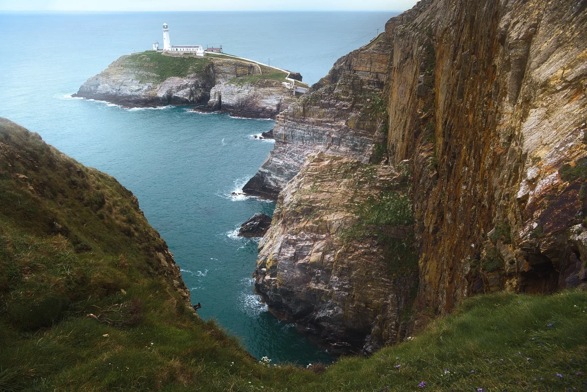
After circumambulating around Rhoscolyn Headland, we drove further up the coastline of Ynys Gybi to revisit a favourite of ours: South Stack. This is a tiny rocky island just off the cliffs of Ynys Gybi, and is home to a picturesque lighthouse. Access is via steep and winding steps that navigate down the sheer cliff face. Every now and then, you get incredible views across the cliffs as you head down the steps.
South Stack lighthouse, shot from higher up the steps. The lighthouse was constructed in 1809 and finally automated in 1983. To begin with, the sole means to traverse to the island was via a basket hung from a hemp rope. Subsequently, in 1828 an iron suspension bridge was constructed, which was then replaced in 1964 by a steel cable truss bridge. Nevertheless, in 1983 it became necessary to close the bridge to the public due to safety issues. Finally, after an aluminium bridge was built, the lighthouse was reopened for public access in 1997. At present, it has become a favoured tourist attraction, drawing many thousands of visitors annually.
Further south from the lighthouse, one can take the path from the RSPCB building down the cliff to Ellin’s Tower, then enjoy a wander along the cliff tops there. A sheer from near Ellin’s Tower gave me this dramatic composition looking back at South Stack and its lighthouse.
Elin’s Tower and, further, South Stack Lighthouse in the distance, with gorse (Ulex europaeus) flowering everywhere. Unusually, gorse in the spring has the strong scent of coconut. Elin's Tower is a Victorian stone tower. This castellated architectural extravagance, initially employed as a summer residence, was constructed between 1820 and 1850 for the prominent Stanley family of Penrhos. It derives its name from Elin (anglicised as "Ellen"), the Welsh spouse of the 19th-century statesman William Owen Stanley.
Did you enjoy these photos?

Port Eynon, Gower, South Wales, Autumn
Just outside of the Pembrokeshire Coast National Park, one can find other excellent stretches of South Wales coastline.
Just outside of the Pembrokeshire Coast National Park, one can find other excellent stretches of South Wales coastline.
East of Pembrokeshire, Swansea is home to the Gower Peninsula and the Gower AONB (Area of Outstanding Natural Beauty). We had already explored a small section of this area at the start of our holiday at Mumbles. But further along the coastline from Mumbles one can find a stretch of fantastical coastline between Port Eynon and Rhossili.
Whereas the cliffs at Lydstep Head were more vertiginous, at the Gower Peninsula the cliffs are formed from a faulted and folded sequence of Carboniferous rocks. More recent sculpting occurred in the last Ice Age as the Gower lay on the southern margin of the last ice sheet. As a result, the cliffs here feature fantastic shapes of curves and folds smashing into each other at peculiar angles.
All photos taken on my Fujifilm X-T2 using my Vivitar “Series 1” 28–105mm f2.8–3.8 zoom and Laowa 9mm f2.8 prime lenses. RAWs converted in Capture One for iPad, developed and finalised in Affinity Photo for iPad.
Port Eynon, Gower, South Wales, Autumn by Ian Cylkowski is licensed under CC BY-NC-SA 4.0![]()
![]()
![]()
![]()
Port Eynon Bay, with its long sandy beach and tall dunes. Port Eynon is thought to be named after Prince Einion of Deheubarth or an 11th-century Welsh Prince named Eynon. “Eynon” is apparently a fairly common surname in Wales.
West of the beach one can hike up the cliffs to summit Port Eynon Point. My lovely Lisabet pictured here heading straight for the knife-edge tip of Port Eynon Point.
Looking back along the limestone cliff edge from Port Eynon Point towards the summit trig point, the open Overton Mere, and the Gower cliffs beyond.
From Overton Mere, looking back at Port Eynon Point, it’s easier to see the folding of limestone that’s occurred around this stretch of the Gower Coast. Seemingly impossible shapes and lines that are entirely natural.
Below Overton cliff more fantastic shapes are revealed, millions of years of folding, faulting, erosion, and glacial scouring.
On top of Long Hole cliff we navigated a join in the folds of limestone to use as a leading line towards the Common Cliffs, as beautiful late afternoon light highlights their shapes.
Did you enjoy these photos?

Tenby & Lydstep Head, Pembrokeshire, South Wales, Autumn
After a morning spent carefully watching the weather apps, it was time to venture out.
After a morning spent carefully watching the weather apps, it was time to venture out.
Southwest of Wales one can find the historical port town of Tenby, or Dinbych-y-pysgod (“Fortlet of the fish”) to give its proper Welsh name. While we drove through the lashing rain, we arrived at Tenby in relatively dry conditions, wandering around the town and its beaches as the clouds gradually lifted and broke apart.
With the light getting better and better, we drove a further ten minutes southwest to Lydstep Head, a new location for us, to check out the area’s fabled cliffs.
Boy it did not disappoint.
Photos taken on my Fujifilm X-T2 using my Vivitar “Series 1” 28–105mm f2.8–3.8 zoom and Laowa 9mm f2.8 prime lenses. RAWs converted in Capture One for iPad then developed and finalised in Affinity Photo for iPad.
Tenby & Lydstep Head, Pembrokeshire, South Wales, Autumn by Ian Cylkowski is licensed under CC BY-NC-SA 4.0![]()
![]()
![]()
![]()
Tenby
St. Catherine’s Island is a tidal island, just off Tenby’s south beach. It’s home to St. Catherine’s Fort, a Palmerston Fort constructed in the 19th century, in response to concerns about an imminent invasion from Emperor Napoleon III of France. Since the 1960s the Fort has stood empty, owned by no-one, though there are community initiatives to accommodate visits and tours.
This is the old Lifeboat Station, built in 1905 and superseded by the newer one just round the corner of Castle Hill in 2008. The old Lifeboat Station is now a private residence. Can you imagine?
As we continued to round the shoulder of Castle Hill the clouds above broke up and lifted. This allowed glorious autumnal sunlight to start emerging onto the scene, highlighting the beautiful coloured buildings of Tenby.
Tenby Harbour, enjoying a lot more sun as the clouds were lifting and breaking. Such a wonderful Welsh coastal scene.
Gosker Rock, which stands conspicuously all on its own on Tenby’s north beach.
Back on Tenby’s south beach, conditions were really starting to get epic. Time to head back to the car and find the cliffs of Lydstep Head.
Lydstep Head
On Lydstep Head, passing squalls quickly dowsed us in rain before carrying on across the sea. Their cloud formations made for epic compositions. I stacked 5 frames on top of each to shoot this photo of the cliffs at Lydstep Point with the rain clouds being lit up in the distance.
East from Lydstep Head another squall dropped a load of rain on top of Caldey Island. I zoomed in for a tighter composition of this fantastic phenomenon.
I mean, wow. The vertical cliff pictured here is Whitesheet Rock, with its dramatic vertical folds. Lots of Pembrokeshire’s coastline is comprised of limestone, which can often produce incredulous rock and karst formations.
A tighter composition of Whitesheet Rock. It doesn’t seem possible that cliff formations can look like this.
The other side of Whitesheet Rock above the aquamarine waters of Lydstep Haven.
Getting some of these compositions around Lydstep Head’s cliffs were some of the most challenging tasks I’ve ever done. The winds coming across the sea were funnelled through and around the geography of the area, creating blusters of 50+ mph. For a lot of these photos, I pretty much had to “spray and pray” to ensure I got something.
Powerful winds force the sea to crash against and around the cliffs of Lydstep Head, as they have surely done for millennia. Who knows what these magnificent cliffs will look like in another thousand years?
Much of Lydstep Head is owned and maintained by the National Trust. Period regenerative grazing occurs here, but closer to the cliffs the land is largely left to do what it will in the elements.
A slow-moving squall sits above Caldey Island in the distance whilst the sun drench the Lydstep cliffs with warm late-afternoon light as powerful winds blast the sea at the seemingly impossible cliffs.
Beyond Lydstep Head to the west, the Pembrokeshire Coastal Path continues over and above the cliffs. That will have to wait for another day.
For this day, circumnavigating Lydstep Head in glorious light and epic conditions was more than enough for the day.
Did you like these photos?
Mumbles, Gower, South Wales, Autumn
A last burst of summer in autumn.
A last burst of summer in autumn.
For our second full day in South Wales we decided to check somewhere we’d never been to before on our previous South Wales explorations: Mumbles.
Mumbles (or Mwmbwls in Welsh) is a headland on the western edge of the Swansea Bay, right on the southern coast of Wales. It has an unusual name, don’t you think? There are different thoughts of where the name comes from:
Exploring French sailors may have named the two rounded islands off the headland les mamelles, meaning “the breasts”, which became corrupted over time;
It could come from the Latin Mamucium, taken from an older Brythonic name, with the mamm- aspect meaning, yes, “breasts”.
We started our hike at Bracelet Bay and the day greeted us with clear skies and a very warm sun. After wandering around the bay and hiking up the limestone crag above the bay—nabbing photos along the way—we carried on the Wales Coast Path west towards Langland Bay.
The views along the way were fantastic. It did not feel like October.
All photos taken on my Fujifilm X-T2 using my Vivitar “Series 1” 28–105mm f2.8–3.8 zoom and Laowa 9mm f2.8 prime lenses. RAWs developed in Capture One for iPad, edited and finished in Affinity Photo for iPad.
Mumbles, Gower, South Wales, Autumn by Ian Cylkowski is licensed under CC BY-NC-SA 4.0![]()
![]()
![]()
![]()
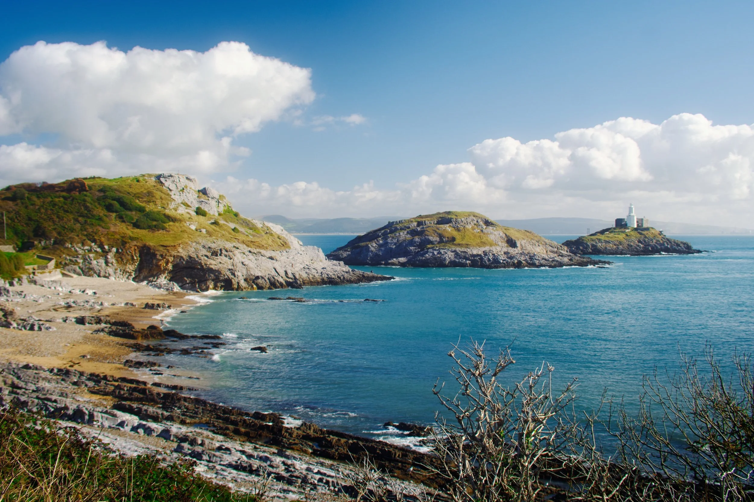
Bracelet Bay, with Mumbles Head to the left, Middle Head dead centre, and Mumbles Lighthouse to the right. You can see why breasts are historically mentioned often in the etymology of Mumbles.
A 9mm ultra-wide composition made from two focus stacked frames of some gorgeous rock samphire with Middle Head and Mumbles Lighthouse in the distance.
Wave-sculpted crags and boulders provided a lovely frame of the Mumbles islands.
I shot a multitude of ultra-wide frames for this composition here, seeking to find the “optimum” way the sea crashed around this sea stack.
We climbed up Mumbles Head for more expansive views of Middle Head, Mumbles Lighthouse, and beyond. Two other guys already there were deep in solemn conversation.
My lovely Lisabet high above the crags of Mumbles Head. Middle Head and Mumbles Lighthouse were starting to catch the sun as it appeared behind the clouds.
An alternative composition as we climbed further up Mumbles Head, with Middle Head attracting the full attention of the sun from behind the clouds.
With the sun dipping behind the clouds again, softer light caressed the shoulders of Mumbles Head and Middle Head. Although breasts are often evoked when viewing these islands, to my mind they’re more like whales of some nature.
Beyond Bracelet Bay we followed the Wales Coast Path west towards Langland Bay. It was turning out to be a corker of a day, the sea glowing a deep aquamarine.
At Rams Tor, looking into the distance at Snaple Point, Whiteshell Point, Pwlldu Head, and Oxwich Point.
Glorious Langland Bay, lined with beach huts and seafront villas. Clearly a popular holiday spot.
The crags of Rothers Torr below the cliffs of Langland Bay.