Crina Bottom, Yorkshire Dales, Spring
After returning from North Wales, but before returning to work, Lisabet and I decided on a wee spring jaunt up to Crina Bottom.
After returning from North Wales, but before returning to work, Lisabet and I decided on a wee spring jaunt up to Crina Bottom.
Crina Bottom is a 400-year old farmstead situated above Ingleton and below the peak of Ingleborough. The route to summit Ingleborough from Ingleton via Crina Bottom is one of the most popular trails to top this famous peak. As such, it’s nicely paved all the way, allowing for easy hiking as the views become increasingly gorgeous.
Once at Crina Bottom, one can enjoy a ridiculous view straight to the flat-topped mountain that is Ingleborough. Just beyond the farmstead, limestone clints and grikes are a photographer’s paradise for compositions.
Plus, we had gorgeous light too.
All photos taken on my Sony α7ii using my Sony FE 28–70mm f3.5–5.6 OSS zoom and Rokinon 14mm f2.8 ED AS IF UMC ultra-wide prime lenses. RAWs developed in Lightroom for iPad, then edited and finalised in Affinity Photo 2 for iPad.
Crina Bottom, Yorkshire Dales, Spring by Ian Cylkowski is licensed under CC BY-NC-SA 4.0![]()
![]()
![]()
![]()
Hiking up Fell Lane to Crina Bottom, a glorious day made shooting this landscape impossible to ignore.
Crina Bottom farmstead with mighty Ingleborough rising above in the distance. Not a bad spot to call home, eh?
Life… finds a way.
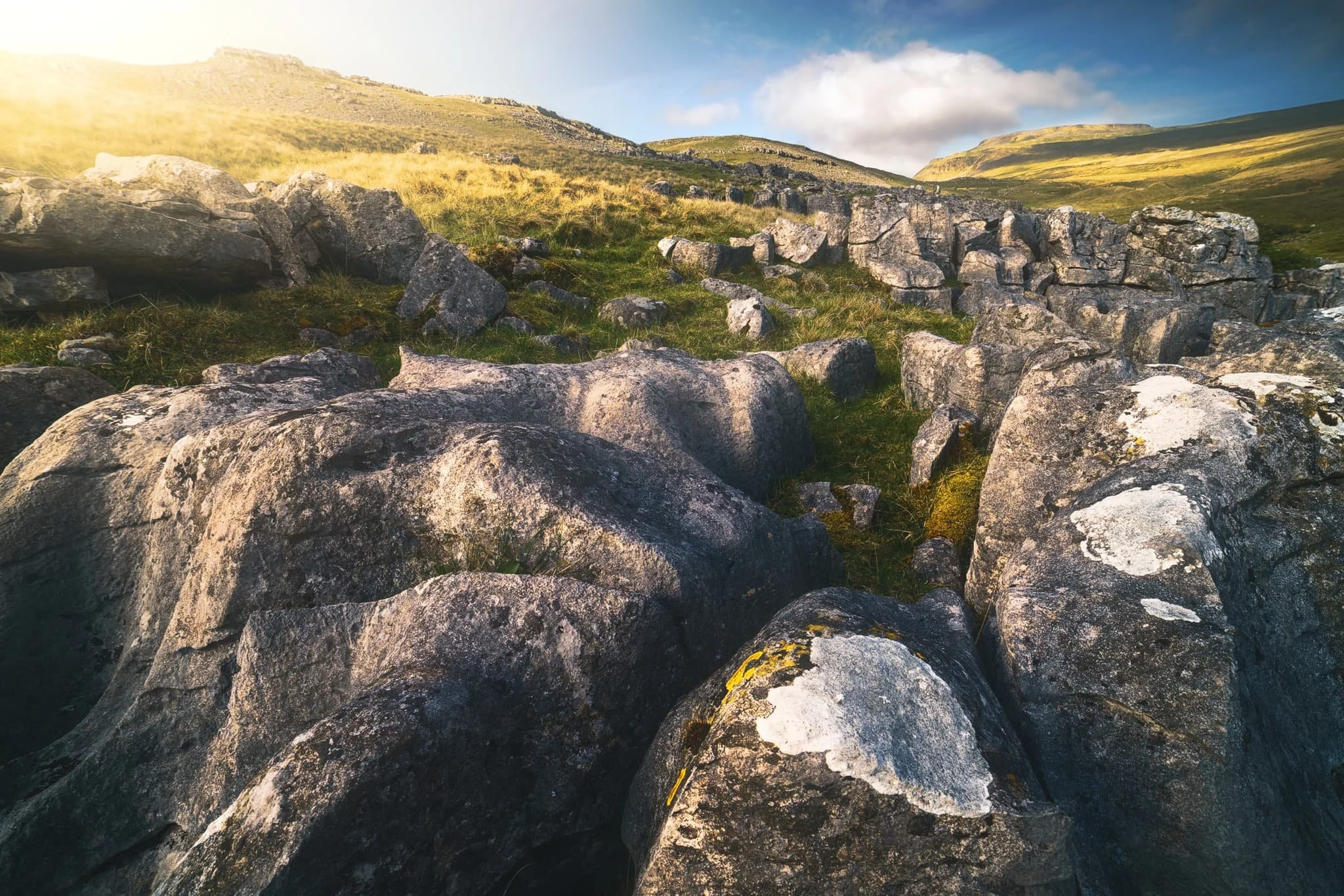
Above the farmstead, one can a lovely patch of limestone clints and grikes to play around with and try out some compositions.
Lisabet, perched on a limestone clint, enjoying the view to Ingleborough.
Evening sun bursts from behind a cloud, pulling out all the delicious textures and forms of the limestone rocks, and brushing a paint stroke across the face of Ingleborough.
Did you enjoy these photos?
Crina Bottom, Yorkshire Dales, Winter
Temperatures are still down but conditions are rather contentious at the moment.
Temperatures are still down but conditions are rather contentious at the moment.
That didn’t stop us from throwing caution to the bitterly cold wind! After examining my 90 million weather apps plus satellite radars, it looked to me that the further east we went, the better our chances for drier conditions.
To the Yorkshire Dales!
We settled on a hike up to Crina Bottom from Ingleton. We did plan on an additional hike from Horton-in-Ribblesdale to Hull Pot, but we unfortunately ran out of time. Nevertheless, Crina Bottom is lovely. It’s famed for its wonderful view of Ingleborough right above the farmstead (a shot of which you can see here). Unfortunately for us on this day, the cloud base level wasn’t due to lift anywhere above 500–600m, and Ingleborough is 726 m high.
Nevertheless, the low winter light was beautiful, casting isolated golden light across the landscape, drawing long shadows, and the low cloud level made for more minimalist landscape compositions.
All photos shot on my Fujifilm X-T2 using my Fujinon 23mm f/2.0 prime lens. Images were made 95% in-camera, with a final curve adjustment in Pixelmator Photo and framing in Darkroom.
We found a spare lay-by off the Ingleton–Hawes road, and already the light was looking gorgeous.
There’s a sparseness to a winter landscape that’s dramatic and beautiful.
It’s only 2.5 miles from the start of this track, known as Fell Lane, to the mountain that is Ingleborough. As such, it’s rather steep in places.
Beautiful golden light greets us as we enter the high-walled portion of Fell Lane.
Across the valley, Twistleton Scar gets drenched in light. Chunks of the drystone wall are still collapsed after Storm Arwen.
Around this part of the track you’d normally expect to see the shoulders of Ingleborough. Not today.
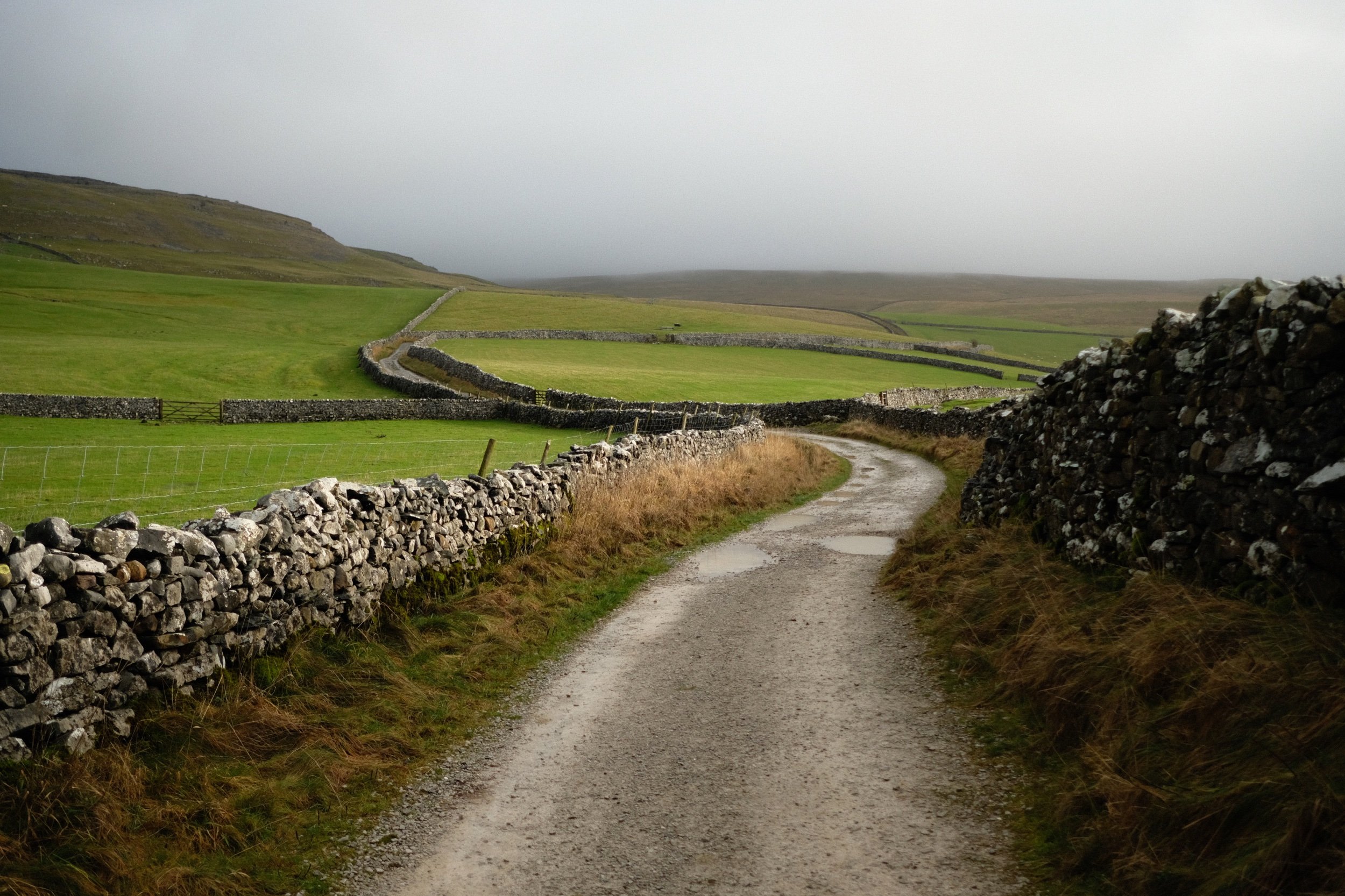
Looking across the fields to the winding walls that guide Fell Lane.
Over the fields towards the Aire Gap and beyond to the Forest of Bowland, the clouds race across the sky and the sun punches through where it can.
Crina Bottom, a remote farmstead that was fairly recently on sale. I think it’s been purchased now. No doubt it will see lots of hikers who use this bridleway to ascend Ingleborough.
Just imagine a giant flat-topped mountain framed in between those trees…
The last time we hiked up to Crina Bottom was August 2017, when I was shooting with my Sigma dp0. Definitely a different world in the winter.
We decided there wasn’t really any point attempting an impromptu hike up to Ingleborough, given that it was completely engulfed in clouds, so we made our merry way back down Fell Lane.
Random bit of fleece, probably from a Swaledale sheep, snagged in the barbed wire.
The long lonnin (lane) back down to Ingleton.
The shadow of Twistleton Scar makes an appearance as storm approaches us from across the Forest of Bowland.
Beautiful Ingleton lay before us near the bottom of Fell Lane. Hmm… a flapjack sounds good about now…
We decided on a wee extra wander into Ingleton town proper to procure a few groceries from the Co-op before hiking back up to the Ingleton–Hawes Road. Ingleton is in a wonderful setting.