Stanage Edge, Peak District, Autumn
Perhaps the Peak District’s most famous edge.
Perhaps the Peak District’s most famous edge.
Froggatt Edge and Curbar Edge were epic enough. But further north, above the bonny village of Hathersage, one can find the massive 3.5-mile long Stanage Edge, which peaks at High Neb 458 m (1,503 ft).
Aside from the height and length of Stanage Edge, and its epic views plus incredible rock formations, the escarpment is famous for rock climbing. Any of the crags and rock walls are not particularly high, perhaps up to 25 m in height, but they are challenging and have been tackled extensively from the mid-20th century onwards.
Thankfully access to Stanage Edge is easy courtesy of numerous small, and free, carparks and road laybys. With the addition of high winds and ever-changing light, we enjoyed an epic hike along this most famous Dark Peak edge.
All photos taken on my Sony α7ii using my Sony FE 28–70mm f3.5–5.6 OSS zoom lens. RAWs developed and edited in Lightroom for iPad, with a little finalising help using Darkroom for iPad.
Stanage Edge, Peak District, Autumn by Ian Cylkowski is licensed under CC BY-NC-SA 4.0![]()
![]()
![]()
![]()
Upon ascending the trail from the off the road, the views immediately open up across the expansive moorland towards Over Owler Tor.
At the trig point 457 m/1,499 ft a. s. l., my Lisabet climbs up to capture those seemingly endless panoramas towards Edale and the Hope Valley.
Smoothed gritstone boulders line the way towards the trig point. Happily, cloud formations above endeavoured to provide another leading line to the trig point.
A drop between two walls provides a nice composition as the light explodes from the clouds, illuminating Over Owler Tor in the distance.
The sun almost completely out, I find a solitary boulder perched precariously on the edge of a gritstone platform.
I crept underneath an overhanging crag that provide me this lovely arrangement of boulders with a view towards Burbage Moor. Fighting the 50+ mph wind gusts, I carefully place the trail below the edge in between the boulders and the crag for a clean leading line.
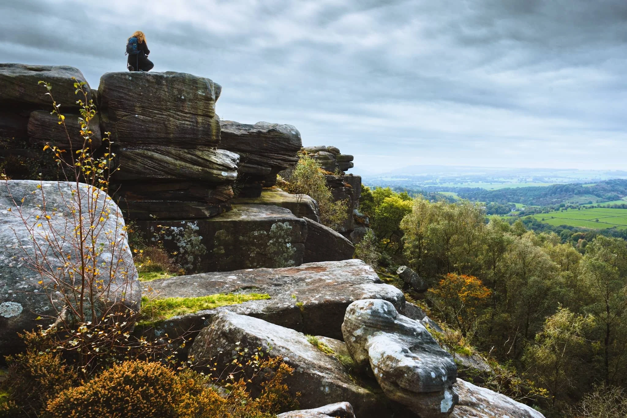
Further north along Stanage Edge I found a few large gritstone boulders, beautifully smoothed and carved by millennia of erosion. They put me in mind of tortoise shells.
A set of beautifully smooth boulders huddle together against the powerful winds. In the distance, you can just make out Hope Valley with Mam Tor and the Great Ridge rising above.
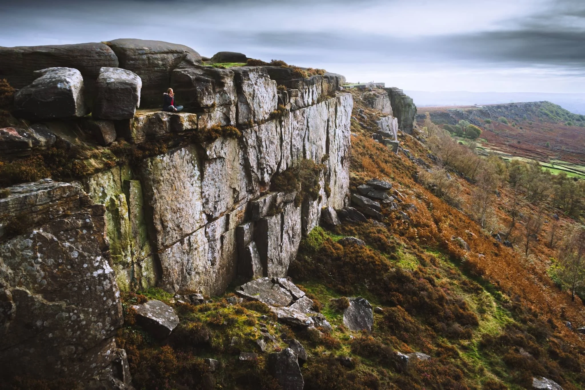
Lisabet enjoyed making me nervous by standing perilously close to the edge of several severe drops. They did, however, make for excellent photos.
Below Stanage Edge the sharp drop down gives way to miles of fern and bracken, now displaying their rusty autumnal hues as they creep up the escarpment wall.
This was about as close to the edge as I dared, in order to nab a composition with these rock formations, like piles of messily stacked CDs.
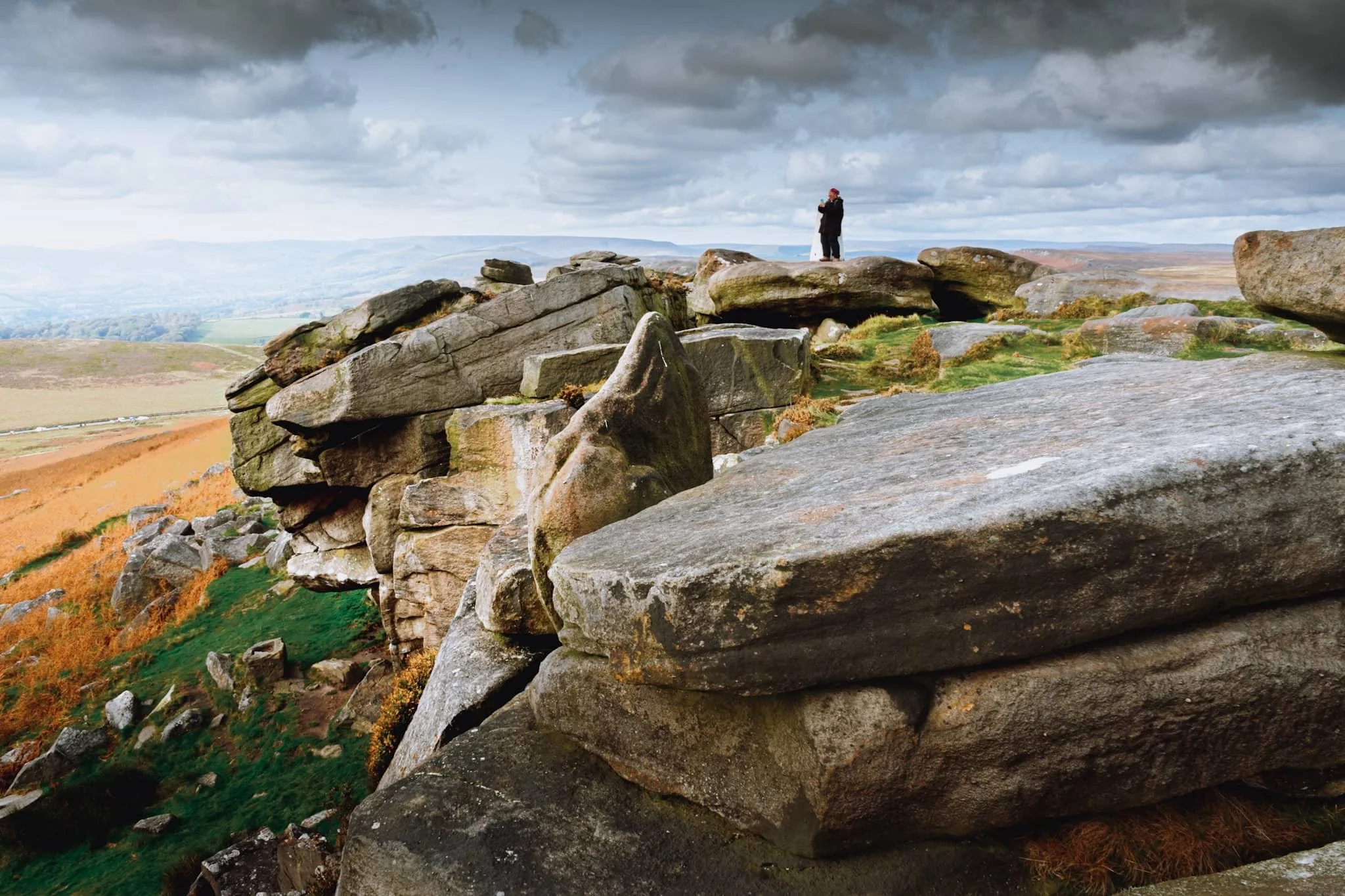
Above Hook’s Car, the drop from Stanage Edge is more vertiginous and clearly an area where rock climbers like to upgrade their skills. People to the bottom-left of the image and on top of the edge to the right show the scale of the place.
This was a particularly popular climbing section, with one climber recently ascending to the top of the edge and victoriously pulling up his rope.
From here, it’s actually possible to make out where the White Peak limestone of the Hope Valley gives way to the eastern Dark Peak gritstone.
There were a few of these boulder bridges spanning across gaps that provided lovely little “portal” style compositions to play around with.
Dark Peak landscapes aren’t really known for their caves, like the White Peak is, but there’s a famous one on Stanage Edge: Robin Hood’s Cave, pictured here with people enjoying the shelter and relief from the wind. Did Robin Hood ever rest in this cave? Who knows?
One of my favourite shots from the day, showing the sheer vertical drop down from Stanage Edge, and the full extent of its length into the distance.
Two pillars of gritstone stacks provide another “portal” composition looking across the moorland towards the Peak District’s limestone plateau.
A wider composition, with Stanage Edge continuing on into the distance on the right. In the middle, Bamford Moor gives way to the rolling hills above Derwent Reservoir.
We located one of the main trails down the escarpment and back towards the road. About halfway down, I couldn’t escape this arresting composition. Miles of rusty ferns with Stanage Edge and clouds above.
Did you enjoy these photos?
Froggatt and Curbar Edges, Peak District, Autumn
If there’s one thing that the Peak District has a lot of, it’s Edges.
If there’s one thing that the Peak District has a lot of, it’s Edges.
The Peak District can roughly be divided into two areas: the White Peak, and the Dark Peak. The naming is based on the underlying geology: the White Park is limestone, and the Dark Peak is gritstone.
You’ll find the Peak District’s edges exclusively in the Dark Peak, particularly the eastern part of the National Park. From below, they appear has formidable walls and cliffs with fantastical rock formations and crags. Beyond those crags usually lies acres of boggy moorland.
On this particular occasion, we decided to explore every nook and cranny of two of the more famous edges: Froggatt Edge and Curbar Edge. They form a near-continuous route, north to south.
The day was bright, much cooler, and clear, save for the creeping clouds that gradually covered the sun as the day went on. Nevertheless, the scenes were absolutely sublime.
All photos taken on my Sony a7ii using my Sony FE 28–70mm f3.5–5.6 OSS and Vivitar “Series 1” 70–210mm f2.8–4.0 zoom lenses. RAWs developed and edited in Lightroom for iPad, finalised in Darkroom for iPad.
Froggatt & Curbar Edges, Peak District, Autumn by Ian Cylkowski is licensed under CC BY-NC-SA 4.0![]()
![]()
![]()
![]()
Starting from the north, the first part of the walk involves a beautiful woodland, Froggatt Woods, full of silver birch and autumnal ferns.
Emerging out of the woods, the views quickly open up and we find our first clump of gritstone boulders to climb around. Lisabet immediately hopped on one for a better view.
Already my excitement levels build as a veritable playground of compositions and rock formations present themselves to me.
A smooth nook in this boulder provided a nice foreground composition, with other crags forming a lead line towards the distant Upper Derwent Valley.
Lisabet’s woodland elf-like abilities means she easily clambers up to the highest boulder to nab those special photos. For me, her slight frame provides wonderful context for the scene.
An isolated pillar of a crag, whipped into otherworldly shapes by millennia or wind and rain, provides a lovely subject for this composition of heather, tors, and across the valley.
Navigating through the various crags and boulders, a little gap catches my eye. As peep through it, a sheer cliff wall down to the valley floor makes my stomach grip. And of course, I snap a photo to convey this sudden drop.
There’s not much separation between Froggatt and Curbar Edge. However, the drop from Curbar Edge is even more severe. This gap between two walls of gritstone provides a lovely leading line towards Baslow Edge in the distance.
Clambering on top of the some of the crags, these beautifully smoothed boulders with deep fissures provide a paradise of compositions, which I line up with Baslow Edge far away.
The staggeringly sheer drop down from the top of Curbar Edge is a sensation I’ll never forget.
This was about as close as I dared to the edge of the precipitous fall to the valley bottom from Curbar Edge.
A stronger burst of sun pulls out all the detail and texture in these windshaped crags.
The amount of heather up on Curbar and Froggatt Edge makes me realise that I need to come back here in late summer, when the heather’s vibrant magenta flowers will carpet the landscape.
Two neighbouring boulders, blasted by wind and rain for millennia, give another gorgeous composition to shoot as stronger sunlight emerges.
Quarrying has occurred on the Peak District’s various edges for centuries. The hard-wearing gritstone made for great millstones, used to grind grain like oats, barley and rye or other feedstuffs.
A lady rests in a nook on Curbar Edge, taking in the panoramic views whilst talking on her phone. She gave the scene a wonderful sense of context and scale that I couldn’t ignore.
Another isolated pinnacle of gritstone catches my eye. As the sun emerges again from the clouds, I line up this composition, using the various boulders to point a zigzagging route to the pinnacle.
Great slabs of gritstone with fissures and covered in lichen allow me to draw another composition looking north as the sun bathes the scene.
After we stopped from lunch using a boulder as shelter, we head back north along the trail. I equip my longer 70–210 mm lens to try and nail some zoomed in, tighter compositions. Here, from the edge, I zoom in on Stony Middleton nestled in its deep limestone gorge.
I enjoyed zooming in on the fell side as it caught the light; the land neatly divided by drystone walls, as a contrast to the pillars of rough gritstone.
Did you enjoy these photos?
Winnats Pass & Mam Tor, Peak District, Autumn
Time to revisit more familiar areas.
Time to revisit more familiar areas.
Last time we attempted to explore Winnats Pass and Mam Tor was way back in May 2015. Back then I was considerably heavier and unfit. Since then I’ve lost a lot of weight and gained fitness. It would be interesting to see how I would fare tackling these locations compared to last time.
Our day started in bonny Castleton, heading west to the foot of Winnats Pass and hiking up the pass alongside the road, a 20% gradient uphill. After reaching the top, we would then continue up the moorland to locate the Mam Tor trail. Then it’s simple enough to follow the path to the summit, along the Great Ridge and then down the valley to Castleton.
Though the tops were windier than in the past few days, it was still unreasonably hot for an October day, pushing 21ºC. In any case, the light was compliant and the views were astounding.
All photos taken on my Sony α7ii using my Sony FE 28–70mm f3.5–5.6 OSS zoom lens. RAWs were developed in Lightroom for iPad, finalised in Darkroom for iPad.
Winnats Pass & Mam Tor, Peak District, Autumn by Ian Cylkowski is licensed under CC BY-NC-SA 4.0![]()
![]()
![]()
![]()
The impressive limestone crags above Winnats Pass dominate the skyline as you make your way up.
Looking back down Winnats Pass from roughly halfway up, the sun starting to rise above the gorge walls.
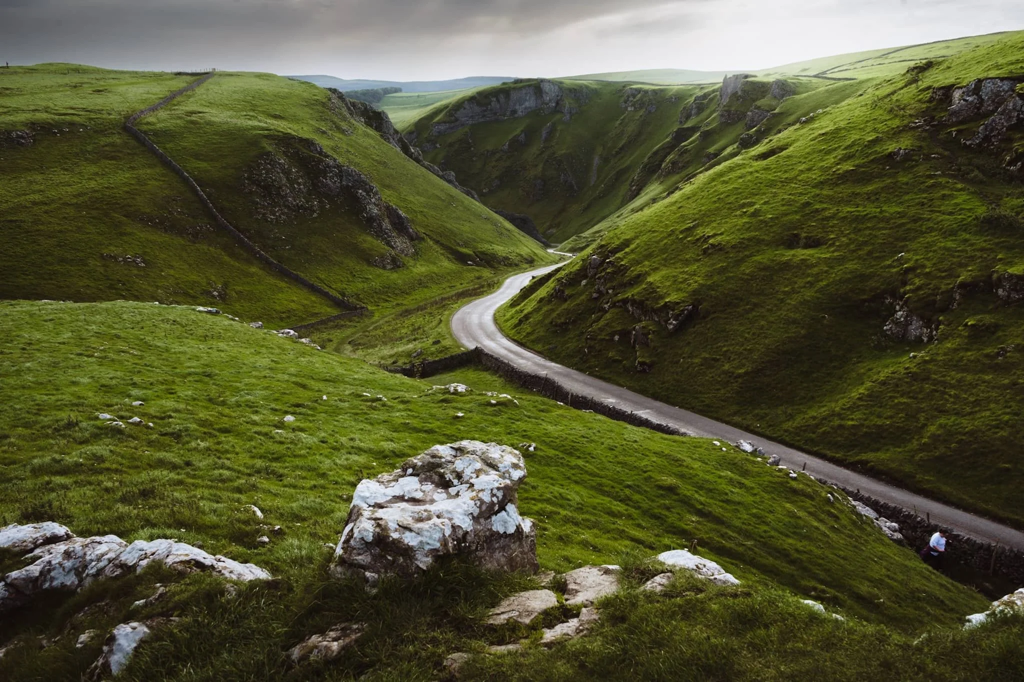
We found an isolated crag that gave us a solid composition looking down the pass. The name “Winnats” is a corruption over time of the original name “Wind Gates” Pass, due to the howling winds that funnel through the gorge.
From the top of the pass, it was easy enough to head up the moorland and locate the Mam Tor trail. Even just climbing up the trail a little bit, the views back down to Rushup Edge are already superb.
Around the shoulder of Mam Tor, the views towards Edale and Kinder Scout above are stunning. Aided, in part, by the winding road as a lovely leading line.
On the way up Mam Tor, the view back towards Winnats Pass reveals the dramatic drop of the gorge. It was once believed to be a giant collapsed cave, but evidence suggests it formed around an underwater canyon. Over time, other rocks covered this area. Much later, erosion revealed the pass we see today, shaped by melting water finding weak points in the rock.
As we climb higher, I find a sheep on the shoulder of Mam Tor, seemingly enjoying the views towards Edale.
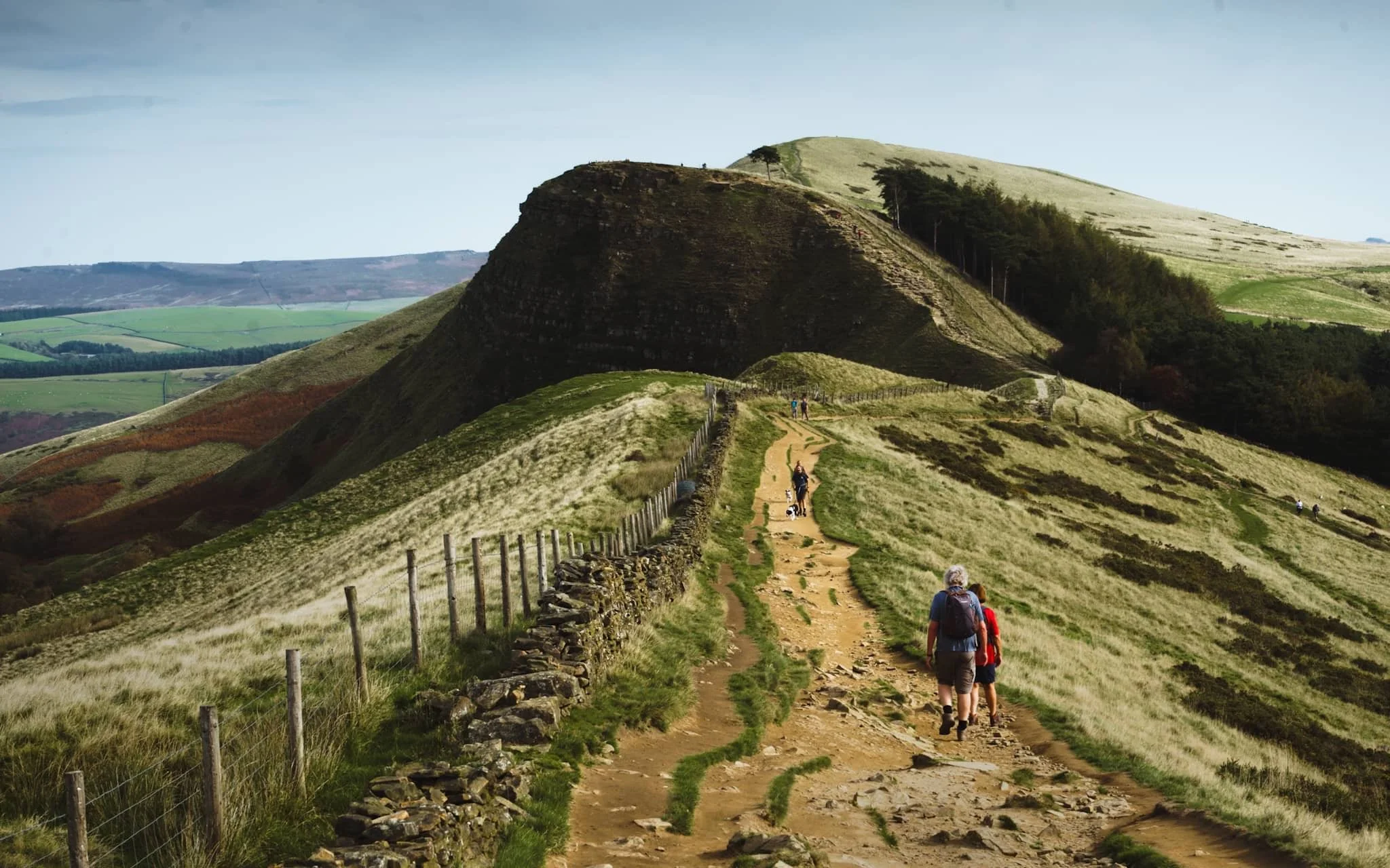
Beyond the summit of Mam Tor, at 517 m / 1,696 ft above sea level, our next goal was clear in front of us: Hollin’s Cross and Back Tor along the Great Ridge.
Near Hollin’s Cross, fellow hikers rest and take the time to enjoy the extensive panoramic views across Edale.
Looking back along the ridge from Hollin’s Cross reveals profile of Mam Tor. The hill is also known as Shivering Hill, as its southeastern face near-constantly sheds rocks and causes landslips. In fact a long-established road underneath this side of Mam Tor, the A625, was abandoned in 1979 due to the constant need to repair the road after landslides.
Beyond Hollin’s Cross, our next destination was unmistakeable: the hulking crag of Back Tor.
Back Tor has similar geology to Mam Tor, and as such what you see is the result of a large shale landslip that falls dramatically down to the valley floor of Edale.
After falling on my arse a few times navigating the muddy trail down from the Great Ridge (and getting punctured by gorse on both occasions), I’m relieved to finally locate a paved country lane. Happily, it was also a nice composition to record.
From almost everywhere in Castleton, the towering crags of Winnats Pass are never far away.
Friends enjoy a pint outside the Bulls Head, whilst Mam Tor’s southeastern face rises clearly in the distance.
Did you enjoy these photos?
Grassington, Yorkshire Dales, Autumn
Autumn is coming.
Autumn is coming.
Knowing that yet more rain was on its way in the afternoon, and that our best chances were further east, we elected to head into the Yorkshire Dales. Here we embarked on a nice 10 km hike, taking in the epic Linton Falls, timeless Grassington, and Grass Wood Nature Reserve.
While there were certainly hints of autumn colours, it seems we need another couple of weeks around our latitude before they reach peak conditions. That’s assuming, of course, that the weather cooperates and doesn’t just blow all the leaves straight off the trees.
Although strictly speaking a town, Grassington has a wonderfully timeless Yorkshire village vibe. As a result, it was selected as the primary location for the 2020 reboot of All Creatures Great and Small, playing the role of the fictional Yorkshire town of Darrowby.
All photos shot on my Sony α7ii using my Sony FE 28–70mm f3.5–5.6 OSS zoom lens. RAWs were largely developed using Capture One for iPad, and finalised using Lightroom for iPad and Darkroom for iPad.
Grassington, Yorkshire Dales, Autumn by Ian Cylkowski is licensed under CC BY-NC-SA 4.0![]()
![]()
![]()
![]()
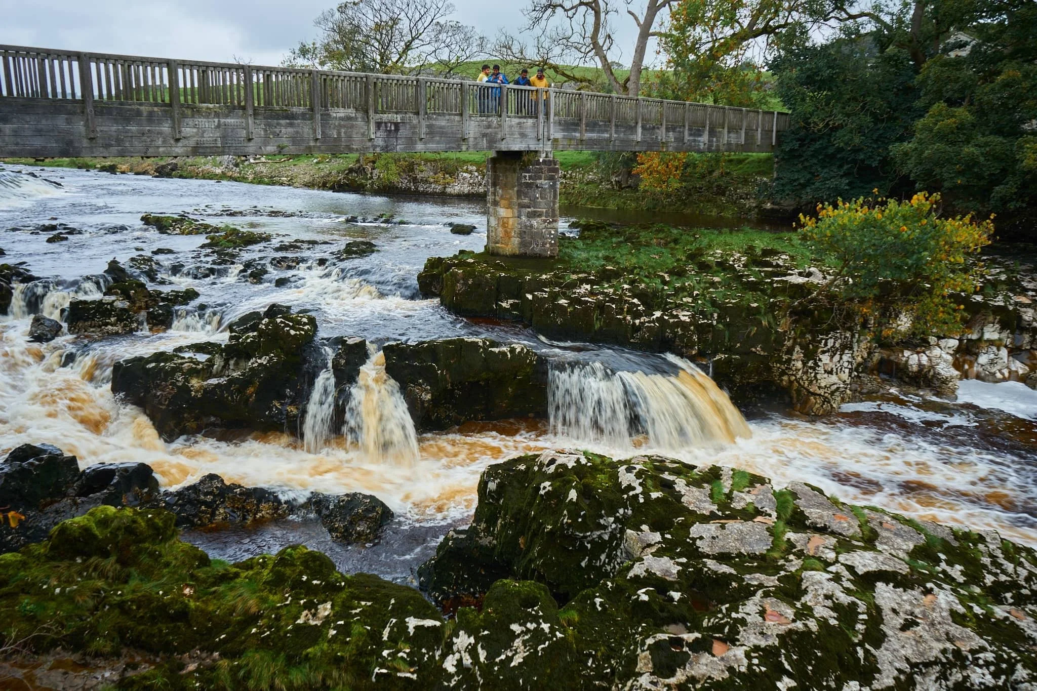
Linton Falls, a series of powerful cascades crashing over a limestone fault in the River Wharfe.
Just above the falls are a couple of weirs that sweep across the river, disrupting the flow of water so as not to sweep away at the river bank so much.

My Lisabet on the footbridge above the thundering falls. It’s quite the drop and a somewhat unnerving sensation.
From the footbridge looking down, it’s easy to make out the fault. Here, a prehistoric seismic shift in the earth will have uplifted some of the limestone in the river bed higher than the rest, creating these cascades and limestone platforms.
Looking upstream, you can make out the second weir and Linton Falls Hydro. There’s been a hydroelectric power station here since 1909, but was closed down in 1948. Decades later, in 2012, the building came back into use once again as a hydroelectric generating power station, modified to minimise harm on nature and local wildlife.
Beyond the footbridge we took the ancient Sedber Lane up the fellside towards Grassington. Looking back down offers an enchanting, if moody, Yorkshire Dales scene.
Grassington. Mentioned in the Domesday Book of 1086 CE, the village was originally documented as Gherinstone, Garsington, or Gersington. The name is a mix of Old Norse and Old English, meaning either “the town of the grassy ings” or a “farmstead surrounded by grass.”
Stopping for some coffee and cake, we then wandered gently around the village documenting some of the more timeless scenes Grassington had to offer (save, of course, for all the vehicles unceremoniously dumped everywhere).
A lot of old architecture in Grassington has survived remarkably well, aiding the village’s “ye olde worlde” appeal.
Bunting zigzagged across the skyline above us as we made our way up the higher parts of Grassington.
The Black Horse Hotel. Originally built in the 17th century as a coaching inn, it saw additions and alterations in the 18th and 19th centuries.
Above the Black Horse Hotel, we continued up Garrs Lane. Save for the road markings, you could easily transport your mind back several centuries, looking at this scene.
A beautiful cottage with window shutters. To the right an old resident had just finished tending to a beautiful garden.
Right near the junction of Main Street, Garrs Lane, and Moor Lane, this wonderful shop—Ashton House Crafts & Carving—was busy displaying all its various sculptures, carvings, and wood chimes. Just delightful.
Chamber End Fold has maintained its cobbled street, helping to cement this ageless Yorkshire scene (if we carefully ignore the car).
We continued up north out of Grassington, taking the ancient Bank Lane onto the Dales High Way and west towards Grass Wood Nature Reserve. Old stone barns decorate the way towards the woods.
These little pops of autumn hues were a tantalising prospect of what is to come.
Grass Wood Nature Reserve is one of the largest broadleaved woodlands in the Dales, comprised primarily of ash woodland interspersed with limestone scars. We followed the minor trail alongside Gregory Scar, thick in the woods.
A delicate little scene, showing the beginnings of those beautiful autumnal colours.
Nearing the exit, this part of the woods was carpeted in fallen autumnal foliage.
Nearing Grassington via Grass Wood Lane, one final composition arrested my attention near the cricket grounds.
Did you enjoy these photos?

Kendal Town, Cumbria, Winter
A new storm has arrived on our shores.
A new storm has arrived on our shores.
Storm Cowrie, like Storm Arwen, has not brought much in the way of rain (at least here in Cumbria) but definitely in terms of wind. There’s already been recordings of 140+ mph winds on the peaks of the Cairngorms in Scotland.
Here in Cumbria, we’ve had gusts of 50–60 mph winds with the occasional spell of mizzle. No peak climbing for us today. Instead, after a lazy lie in, we enjoyed a brisk and lengthy walk around the place we call home: Kendal, the Auld Grey Town.
All photos taken on my Fujifilm X-T2 using my Fujinon 23mm f/2.0 lens. Shot using the Velvia film simulation, edited in Lightroom, and finished in Darkroom.
It’s no Big Ben, but Kendal Town Hall’s clock tower is unmistakeable in any direction.
Heading up one of Kendal’s steepest roads, Beast Banks, I stopped for a shot down Garth Row, a medieval footpath linking Beast Banks with Captain French Lane.
Up Brigsteer Road, the light started to improve, highlighting these trees covered in vines.
A casualty of Storm Arwen, cut up before removal from the footpath. I wonder how many more trees will be felled by Storm Corrie.
A picture of suburbia. The small knobby hill in the distance is The Helm.
One of many old stone bridges in Kendal that cross the River Kent. This is Nether Bridge. It has records dating from the 14th century, and the 18th century packhorse bridge still exists underneath this newer 19th century construction.
The Almshouses on Aynam Road, originally built in the 19th century and named the “Sleddall Victoria Jubilee Alms Houses”.
Aynam Mills, originally built for processing snuff, which Kendal became known for making during the 18th and 19th centuries after the decline of the woollen industry.
Some of Kendal’s older buildings have definitely seen better days.

St. Bees, Cumbria, Winter
For our final full day of our mini-break, a trip to the coast was in order.
For our final full day of our mini-break, a trip to the coast was in order.
The weather forecast for the day had the fells of the Western Lake District blanketed in clouds. Instead, the westernmost point of Cumbria seemed like a good alternative.
St. Bees is a small village on the western coast of Cumbria. In comparison to the deep dales and high fells that characterise the Cumbrian landscape, most of Cumbria’s coastline consists of long sandy beaches, stretches of shingle, the occasional dune, and mudflats nearer Morecambe Bay. The exception to this rule lies at St. Bees, where St. Bees Head towers above the coastal village.
St. Bees Head is split into two sections: the South Head (which overlooks St. Bees village, and is known locally as the Tomlin), and the North Head. In between the two headlands is Fleswick Bay, accessible only by foot or sea. The small bay consists of deep shingle underfoot and towering sandstone cliffs in an array of otherworldly and seemingly impossible shapes and arrangements.
It’s been a good few years since we’ve hiked St. Bees Head, and it’s nice to reaffirm that our fitness has greatly improved since the last visit. St. Bees Head, and Fleswick Bay, did not disappoint.
All photos taken on my Fujifilm X-T2 using my three prime lenses: a Fujinon 23mm f/2.0, a Laowa 9mm f/2.8, and an adapted 55mm f/2.0. All images made in-camera using a custom Velvia-based recipe, finished for the web in Pixelmator and Darkroom.
Our destination for the day: St. Bees Head from the shore at St. Bees.

The views open up the minute you step on the cliff path. It’s fair to say that St. Bees Head has seen it’s fair share of erosion.
The cliff path reveals the extent of the St. Bees coastline. Much of the Cumbrian coastline is like this.
The first section up to the top of the South Head is quite the pull.
Yeah, that’s pretty steep. If the path were more wet and muddy, I’d have really struggled.
Thankfully it’s not long before the cliff path levels out, and gorgeous panoramas to St. Bees village and the Lakeland fells open up.

Near the old coastguard lookout, a fantastic view towards the headland’s sheer cliffs and Fleswick Bay beyond is possible. The path used to follow this cliff top quite closely, but erosion has meant the path has moved further inland.
To be safe, we stayed on the inland side of the path. The cliffs surrounding Fleswick Bay become more visible.
Despite the heavy cloud cover, the light conditions were being very cooperative.
Lots of gorse, Ulex europaeus, can be around the cliff tops of St. Bees Head. They’re not quite flowering yet, but those that have offered a nice composition as we neared Fleswick Bay.
The way down to Fleswick Bay nears.
Getting down to Fleswick Bay can be tricky. The path is often muddy, and the deep gill leading out to the bay is lined with moss-covered loose boulders. I did, dear reader, fall on my ass trying to get to the bay.
Our preservation paid off. This is Fleswick Bay and her incredible cliffs.
My lovely Lisabet, providing a sense of scale against the deep red jenga-like cliffs of Fleswick Bay.
It was time to fit my ultra-wide 9mm lens on to nab some expansive compositions of Fleswick Bay’s strange cliff textures.
Millennia of wave action have torn chunks off the cliff face, and smoothed out boulders.
Getting right low and underneath the cliffs with my ultra-wide lens provided some incredible angles.
Most of the sandstone cliffs are wet and constantly dripping water from the grass and soil above.
Our footprints are testament to how soft and deep the shingle goes. Really hard to walk in. We ventured as far out as we dared with the tide making its way in.
What now follows is a celebration of the weird and wonderful textures and patterns of Fleswick Bay’s sandstone cliffs.

This is the deep gill that flows out into Fleswick Bay.
And this is the reason why it’s quite hazardous to navigate your way back onto the cliff path.
But navigate we did. We were the only ones at Fleswick Bay this whole time. Everyone else seemed more interested in sticking to the cliff path.
One last look back at the cliffs of Fleswick Bay before making our way back to St. Bees.
Heading back to St. Bees, the light got better and better and I went on a shooting spree whilst it lasted. In the distance, a think bank of cloud sits on top of the Black Combe fells.
As the sun began its trajectory down into the sea, plenty of people will still heading up and down the cliffs of St. Bees Head.
St. Bees getting drenched in golden wintersun with the dark Muncaster Fells behind.
My lovely Lisabet, striding purposefully on towards St. Bees village as the sun bathed the land in light.