
Caldbeck, Lake District, Spring
Happy Easter, everyone.
Happy Easter, everyone.
I hope everyone has had/is having a safe and enjoyable Easter. It’s certainly helped that most of the country has experienced relatively dry, bright, and clear conditions during the Easter break.
Lisabet and I ventured north to hang out with my Dad for Easter Sunday. After prepping a good hunk of silverside beef in the slow cooker, we nipped to the nearby village of Caldbeck for a simple hike around The Howk and Priest Mill. Nowt particularly “epic”, but after Saturday’s 20km hike, our bodies were ready for something a little easier on the knees and thighs.
Caldbeck is a beautiful village situated right on the northern edge of the Lake District National Park. It is an old village, with houses still standing—and in use—since the 1600s. West of the village one can enjoy a lovely little stroll into a small wooded gorge, which once housed a Bobbin Mill, now in ruins. This area is known as The Howk, and features several small yet powerful waterfalls as they slowly, yet ceaselessly, carve out the gorge. East of the village is Priest’s Mill, where one can find another series of delightful cascades.
All photos shot on my Fujifilm X-T2 using a Samyang 35mm f/1.2 lens and a Laowa 9mm f/2.8 lens. This was also the first opportunity I had to try out my new Marumi Super DHG Circular Polariser for my Samyang lens. Developed using RNI’s Agfacolour XPS film profiles.
This is the old Bobbin Mill near the entrance of the limestone gorge known as the Howk. Bobbin Mills in Cumbria, such as this, once accounted for half of all bobbins produced in Britain. A “bobbin” is a “spindle or cylinder on which wire, yarn, thread, or film is wound” (thanks, Wikipedia).
This is one of the main waterfalls around the Howk as it plunges through the limestone gorge. My 9mm ultra wide lens never ceases to amaze me at how much of a scene it captures.
A shot from the other side of the bridge. I’d never realised quite how much wild garlic grows in the Howk. Soon this gorge will be filled with tiny white flowers.
One of the main reasons why I bought a polariser: I love how it cuts the glare from water and vegetation. It really deepens the colours in a scene.

Looking back at the footpath through the woods, carpeted on either side in wild garlic. I love how Agfacolour XPS renders the greens.
This is the first drop of the Howk, which ultimately creates the gorge. Further upstream the beck is largely calm.
One last look back into the woods before we ventured further upstream and out into the fields outside Caldbeck.
The rolling fields around Caldbeck.
Back near the village green I snapped this quick shot of a couple of ducks diving in a pond. They don’t half look funny.
This area is one of the oldest parts of Caldbeck, featuring houses built into the 1650s.
Caldbeck is ridiculously pretty. A proper quintessentially British rural idyll.
We took the beckside path east to head to Priest’s Mill.
Et voila! A beautiful waterfall near Priest’s Mill.
Winder, Howgills, Cumbria, Spring
We’ve neglected the Howgills for too long.
We’ve neglected the Howgills for too long.
On this Good Friday we elected to stay away from the Lake District, expecting visitor numbers to sharply increase. We did want to stay within the same council area, though. So we ventured east over the M6 and into Sedbergh, the beautiful bookish town at the foot of the Howgills.
It might be reasonable to state that the Howgills as a landscape tends to get overlooked, or even ignored, in favour of nearby neighbours such as the Lake District and the Yorkshire Dales. Lisabet and I have certainly been guilty of this assumption. But the Howgills has a lot of beautiful wandering to offer, and we’ve barely scratched the surface.
We exited the town onto Joss Lane, which leads onto the Dales High Way. Then it was a simple matter of following this footpath and its incredible views of Settlebeck Gill all the way onto the plateau, before turning back sharply to reach the summit of Winder (473 m/1,552 ft).
A glorious spring’s day was in full effect, with clear and deep blue skies all around.
And there are many more of the Howgills to check out.
All photos taken on my Fujifilm X-T2 using a Samyang 35mm f/1.2 lens and an adapted Pentax SMC 55mm f/2.0. Developed using RNI’s Kodachrome film profiles.
Sedbergh is a beautiful little town.
After exiting Joss Lane we merged onto the Dales High Way, soaking in the beautiful spring sun as we did.
There were plenty of others out and about on the Howgills too, and on such a beautiful day I don’t blame them.
Looking back the way we came.
A well-positioned bench offers walkers a rest and a view of the Dentdale fells.
We were keen to stay on the main footpath, but others elected to ascend the Winder summit as quickly as possible.
With every step the panorama opened up more and more. It was hard to maintain a forward momentum up the fell path when these views commanded our attention behind us all the time.
The way forward. Nary a cloud int’ sky.
Here we’re nearing the first main plateau of the Dales High Way, which also signalled us to take a sharp left in order to reach the summit of Winder.
One last look back down, with the full extent of Settlebeck Gill below, the Sedbergh countryside in the middle distance, and the Dentdale fells of the Yorkshire Dales in the background.
Fell ponies grazing peacefully on the flanks of Green Mea.
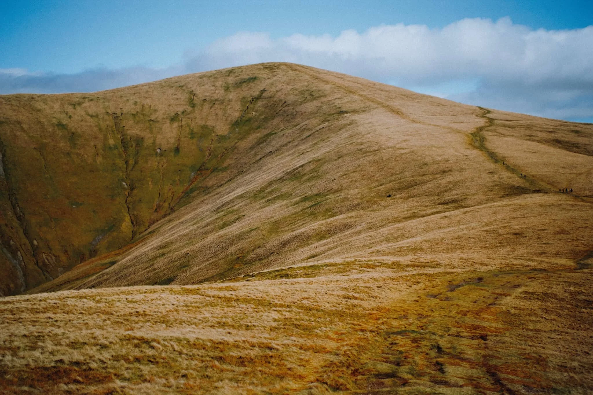
What a sight. The Dales High Way carries on around the flank of Arant Haw (605 m/1,985 ft), a beautifully sculpted fell with a precipitous southwestern face.
Our destination meant turning away from the Dales High Way, back to the southwest towards Winder. Along the way I keep snapping the views over to the heart of the Yorkshire Dales.
Across Settlebeck Gill is Winder’s easterly neighbour, Crook (461 m/1,513 ft). Far in the distance are the Mallerstang fells.
And… summit. On a clear day, such as we enjoyed, the views take in the Lake District fells and even Morecambe Bay, 32 km away.
After a flapjack and some water whilst sheltered underneath the trig point from the wind, we followed the track back down the southwestern shoulder of Winder.
Layers upon layers of hills and valleys in the Howgills. In fact, that’s where the Howgills get their name from. “How” comes from the Old Norse haugr meaning “hill”, and “gill” comes from the Old Norse gil meaning a “narrow valley”.
The winding track back to Sedbergh via Lockbank Farm. The round mound in the distance is Aye Gill Pike (556 m/1,824 ft).
Ostensibly looking back at the way we came, but more than I shot this composition for the winding drystone wall. That’s right.
So many lambs around. Always a wonderful sight to see and sound to hear.
Swaledale lambs, being adorably playful.
My lovely Lisabet, enjoying a drop of Sherry in her friend’s garden post-walk.