
Hull Pot, Yorkshire Dales, Winter
A month since my last post.
A month since my last post.
I do apologise.
The weather in January has been, well, shocking to say the least. We endured three named storms: Henk, Isha, and Jocelyn. Isha, in particular, was one of the most powerful storms the British Isles have seen since 2000.
Additionally, we’ve had periods of below freezing temperatures, resulting in widespread ice.
It’s been… interesting.
Thankfully, the weekend just gone, it was nice enough for us to finally head out. We chose the Hull Pot route from Horton-in-Ribblesdale in the Yorkshire Dales. I had an inkling that there’d still be some snow liggin’ about in the Dales, contributing to a water-saturated landscape and, hopefully, a waterfall flowing into Hull Pot.
And we finally saw it.
All photos taken on my Sony α7ii using my Pentax SMC 28mm F3.5, Pentax SMC 55mm f2.0, and Rokinon 14mm f2.8 ED AS IF UMC prime lenses. RAWs developed in Lightroom, edited and finalised in Photoshop.
Hull Pot, Yorkshire Dales, Winter by Ian Cylkowski is licensed under CC BY-NC-SA 4.0![]()
![]()
![]()
![]()
The characteristic drystone walls of the Yorkshire Dales remained steadfast in the face of all the snow we’ve had recently, resulting in these snowdrifts piled up against them.
Our way forward. We knew on this day that there’d only be 2-3 hours of good light, and boy was it dramatic.
Looking back at where we came from. We were very much on the edge of two weather systems. Conditions over Horton-in-Ribblesdale saw blue skies and puffy clouds, but closer to Pen-y-Ghent it was blowy, dark, and stormy, giving us epic light.
A good sign: A small waterfall where there usually isn’t at Horton Scar. Above, Pen-y-Ghent fights with the dark and stormy clouds.
Further up the bridleway, the site of an extinct waterfall below Pen-y-Ghent, which is now obscured by clouds laden with snow. A burst of sun to our right picks out the details in the land.
And there she is, finally ticked off my bucket list. England’s largest natural hole, Hull Pot, with Hull Pot Beck tumbling down 60ft into the chasm. As mentioned before on this blog, Hull Pot is a large cave where the roof has collapsed, which has resulted in this massive chasm below Pen-y-Ghent. With my ultra-wide 14mm equipped, I was able to capture the entire scene.
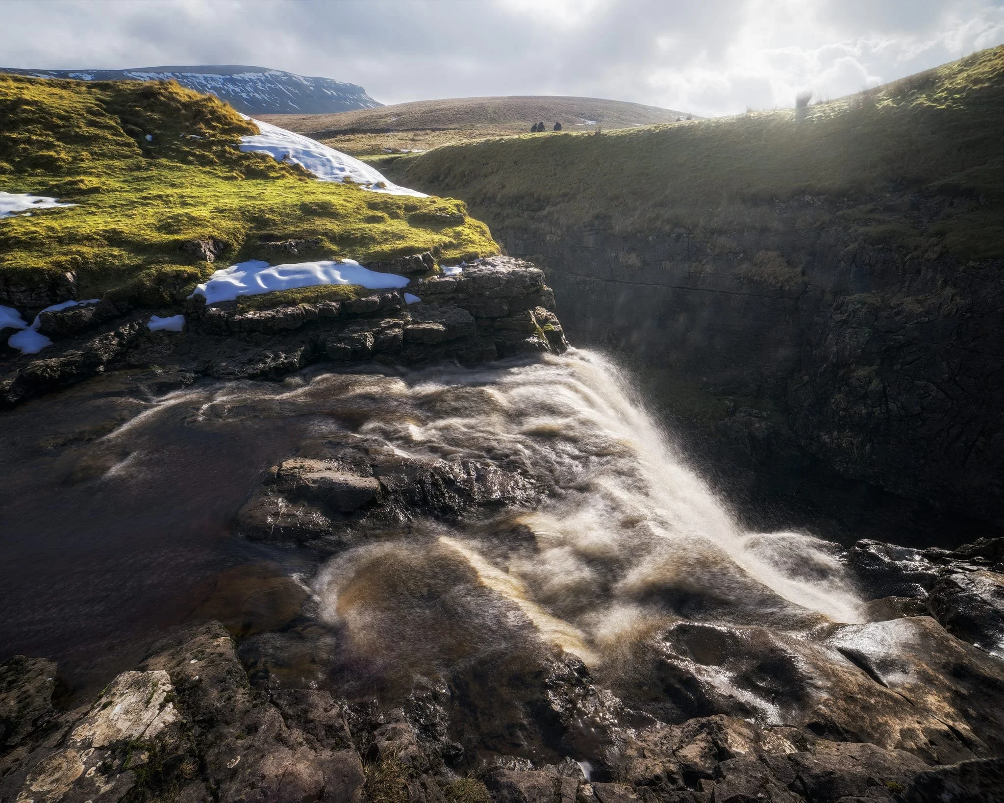
We clambered as close to the waterfall as possible as it crashed over the edge into Hull Pot. As I had no tripod, I shot this with my ultra-wide 14mm at f/22, taking multiple exposures of the same scene. In post, I then averaged the exposures together that gave me that long exposure effect on the water.
Looking up Hull Pot Beck and its many cascades. By the normal way of things, this beck is dry as it usually disappears into the maze of caves beneath Pen-y-Ghent before it reaches Hull Pot. With all the rain and snow we’ve had, the beck was able to complete its route, crashing 60ft down into Hull Pot and re-emerging at the surface nearer Horton-in-Ribblesdale.
A different view of Hull Pot from its eastern end. Two boulders balance precariously on the lip of the pot.
At around 450 m/1,476 ft above sea level, a few snow patches have lingered around the edges of Hull Pot, allowing for some interesting compositional leading lines.
A particularly clean snow patch nearer the falls gives me an idea for a composition involving Pen-y-Ghent in the distance. Fellow hikers milling about the edge of Hull Pot give you a sense of scale of this place.
Heading back down to the village, signs were clear that the best of the day’s light were done as the storm clouds rolled in. We were thankful to get what we did, though.
Did you enjoy these photos?

Clapham & Trow Gill, Yorkshire Dales, Winter
The seasons progress and the weather is changing.
The seasons progress and the weather is changing.
After a month of near-constant rain interspersed with heavy fog, a high-pressure system is moving in and bringing with it clearer skies and lower temperatures.
Winter has arrived.
On Saturday we were greeted with clear skies and a biting wind. We ventured into the Yorkshire Dales—Clapham, to be precise—for a hike up towards and above Trow Gill. We would then scramble through the gill to get to the high moorland above for extensive panoramic views.
It were a crackin’ day for it.
All photos taken on my Fujifilm X-T2 using my Vivitar “Series 1” 28–105mm f2.8–3.8 zoom and Laowa 9mm f2.8 prime lenses. Developed in Capture One with the “Classic Chrome” Fujfilm simulation, finalised in Affinity Photo 2 for iPad,
Clapham & Trow Gill, Yorkshire Dales, Winter by Ian Cylkowski is licensed under CC BY-NC-SA 4.0![]()
![]()
![]()
![]()
It’d been a long time since I visited Clapham. In fact, I can recall the last time because I was still shooting with a Nikon D7000 that was nearly permanently attached to a tripod. This means the last time I was at Clapham was around 2016. Wow.
Here is something I do not remember from our last visit: a friggin’ waterfall! Turns out there’s been a lot of conservation work in recent years, some of which involved clearing the riverside bank here of snowberries, which was obscuring views of this waterfall.
The last of the year’s autumn colours in beautiful winter light.
Clapham Falls is a man-made waterfall, constructed as a three-tier drop underneath a bridge in the early 19th century by the Farrer family. They’ve long had established ties to the village and the 19th century saw a lot of landscaping and remodelling of the village.
This is something I wasn’t expecting to see in winter: flowering plants! I think this might be Mahonia japonica, which is apparently native to Taiwan. It flowers in winter through to spring.
After working our way up and through Clapdale Wood and past the famous Ingleborough Show Cave we finally arrived at the entrance to Trow Gill.
Trow Gill is an immense ravine with 200ft high cliff walls. It was once the site of a massive waterfall, much like Troller’s Gill near Appletreewick.
We scrambled up the gill to access the high moorland above. From here, looking back down, I start to imagine what the waterfall would’ve looked like and the forces involved in sculpting this ravine. Immense.
The beck which once flowed through here as a raging waterfall begins life on the eastern slopes of Ingleborough. At some point in the distant past the beck no longer reached this ravine, instead falling underground near Ingleborough down a giant cavern now known as Gaping Gill. It is technically England’s single biggest drop waterfall, even though it falls underground.
Scrambling up and out of the gill, the land begins to open up and we can start to glimpse the eastern aspect of Ingleborough.
Above us, to the north, a limestone scar is drenched in winter light whilst the sky is ominously dark and cold.
The more unfamiliar view of Ingleborough. To the left is Little Ingleborough, with the main fell to the right. Though the trail continues on towards the fells, we decided to loop back and reconnect with the Pennine Bridleway.
Zooming right in on Little Ingleborough. You can just make out the tiny figures following the trail up the fell.
Up on the moorlands above Clapham, the views massively open up. Beyond Thwaite Scar we could make out the distant yet distinct shape of Pendle Hill, all the way in East Lancashire.
Even more impressively, Pen-y-Ghent was clear as a bell and looking spectacular.
The rolling landscape of the Yorkshire Dales, interspersed with karst limestone formations such as limestone pavements, scars, ridges, and of course the distinctive isolated fells.
Back on the Penine Bridleway south to Clapham, Thwaite Scar receives some late afternoon golden light.
Before dropping down to the village, I nab one final composition of Robin Proctor’s Scar—a sheer cliff face—being bathed in golden winter light.