Grassington, Yorkshire Dales, Autumn
Autumn is coming.
Autumn is coming.
Knowing that yet more rain was on its way in the afternoon, and that our best chances were further east, we elected to head into the Yorkshire Dales. Here we embarked on a nice 10 km hike, taking in the epic Linton Falls, timeless Grassington, and Grass Wood Nature Reserve.
While there were certainly hints of autumn colours, it seems we need another couple of weeks around our latitude before they reach peak conditions. That’s assuming, of course, that the weather cooperates and doesn’t just blow all the leaves straight off the trees.
Although strictly speaking a town, Grassington has a wonderfully timeless Yorkshire village vibe. As a result, it was selected as the primary location for the 2020 reboot of All Creatures Great and Small, playing the role of the fictional Yorkshire town of Darrowby.
All photos shot on my Sony α7ii using my Sony FE 28–70mm f3.5–5.6 OSS zoom lens. RAWs were largely developed using Capture One for iPad, and finalised using Lightroom for iPad and Darkroom for iPad.
Grassington, Yorkshire Dales, Autumn by Ian Cylkowski is licensed under CC BY-NC-SA 4.0![]()
![]()
![]()
![]()
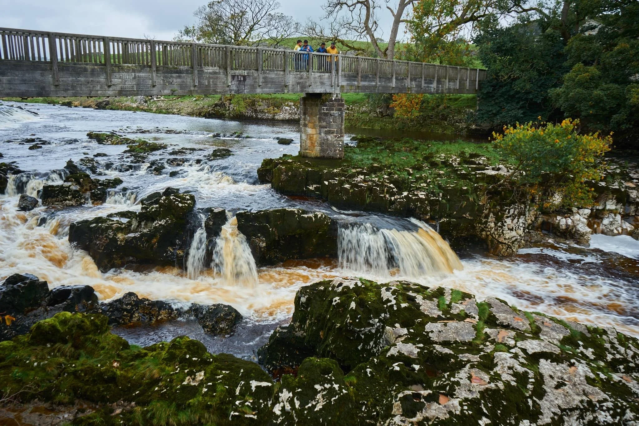
Linton Falls, a series of powerful cascades crashing over a limestone fault in the River Wharfe.
Just above the falls are a couple of weirs that sweep across the river, disrupting the flow of water so as not to sweep away at the river bank so much.

My Lisabet on the footbridge above the thundering falls. It’s quite the drop and a somewhat unnerving sensation.
From the footbridge looking down, it’s easy to make out the fault. Here, a prehistoric seismic shift in the earth will have uplifted some of the limestone in the river bed higher than the rest, creating these cascades and limestone platforms.
Looking upstream, you can make out the second weir and Linton Falls Hydro. There’s been a hydroelectric power station here since 1909, but was closed down in 1948. Decades later, in 2012, the building came back into use once again as a hydroelectric generating power station, modified to minimise harm on nature and local wildlife.
Beyond the footbridge we took the ancient Sedber Lane up the fellside towards Grassington. Looking back down offers an enchanting, if moody, Yorkshire Dales scene.
Grassington. Mentioned in the Domesday Book of 1086 CE, the village was originally documented as Gherinstone, Garsington, or Gersington. The name is a mix of Old Norse and Old English, meaning either “the town of the grassy ings” or a “farmstead surrounded by grass.”
Stopping for some coffee and cake, we then wandered gently around the village documenting some of the more timeless scenes Grassington had to offer (save, of course, for all the vehicles unceremoniously dumped everywhere).
A lot of old architecture in Grassington has survived remarkably well, aiding the village’s “ye olde worlde” appeal.
Bunting zigzagged across the skyline above us as we made our way up the higher parts of Grassington.
The Black Horse Hotel. Originally built in the 17th century as a coaching inn, it saw additions and alterations in the 18th and 19th centuries.
Above the Black Horse Hotel, we continued up Garrs Lane. Save for the road markings, you could easily transport your mind back several centuries, looking at this scene.
A beautiful cottage with window shutters. To the right an old resident had just finished tending to a beautiful garden.
Right near the junction of Main Street, Garrs Lane, and Moor Lane, this wonderful shop—Ashton House Crafts & Carving—was busy displaying all its various sculptures, carvings, and wood chimes. Just delightful.
Chamber End Fold has maintained its cobbled street, helping to cement this ageless Yorkshire scene (if we carefully ignore the car).
We continued up north out of Grassington, taking the ancient Bank Lane onto the Dales High Way and west towards Grass Wood Nature Reserve. Old stone barns decorate the way towards the woods.
These little pops of autumn hues were a tantalising prospect of what is to come.
Grass Wood Nature Reserve is one of the largest broadleaved woodlands in the Dales, comprised primarily of ash woodland interspersed with limestone scars. We followed the minor trail alongside Gregory Scar, thick in the woods.
A delicate little scene, showing the beginnings of those beautiful autumnal colours.
Nearing the exit, this part of the woods was carpeted in fallen autumnal foliage.
Nearing Grassington via Grass Wood Lane, one final composition arrested my attention near the cricket grounds.
Did you enjoy these photos?

Stock Ghyll Force, Lake District, Summer
We’re doing lots of rain dodging at the moment.
We’re doing lots of rain dodging at the moment.
But that’s OK, because lots of rain means thunderous waterfalls.
Lisabet and I decided to head straight out after work for a hike around Stock Ghyll Force in Ambleside, before the rain arrived. We timed it well. Five minutes after getting back in the car to head home, the heavens opened and our car was washed.
Stocky Ghyll begins life where Kirkstone Pass meets The Struggle. It’s here that Snow Cove Gill and Grove Gill combine below Kirkstone Pass and head southwest towards Ambleside. Just outside the town Stock Ghyll splits into two (or three, if it’s been raining heavily), drops 70ft down Stock Ghyll Force and merges together again at the bottom of the falls before draining into Ambleside.
Photos shot on a Fujifilm X-T2 with a 16–50mm f/3.5–5.6 lens using a customised Velvia film simulation.
Stock Ghyll Lane, the road towards the falls, with some lovely soft light.
The day was wonderfully overcast, lending some beautiful pockets of highlighting at various points in the ravine of Stock Ghyll Force.
The upper part of Stock Ghyll Force. This composition was made from 5 shots at 16mm (24mm full-frame equivalent), stitched together from top to bottom.
Just above the falls Stock Ghyll cuts a deep groove before dropping 70ft as Stock Ghyll Force. My lovely Lisabet providing a sense of scale here.
One of the more popular and accessible views of Stock Ghyll Force. It’s classical profile is in view here, showing two falls becoming one, but after enough rain there’s usually a 3rd waterfall to the left. You can just make out its trickle here.
A less-visited view of Stock Ghyll Force, with some soft light breaking through the canopy.

Isolation: Natland, Cumbria, Spring 2020
There is a global pandemic. Coronavirus (COVID-19) is here.
This is the point where the wide and lazy River Kent drastically narrows into a limestone gorge. The colour of the water was mesmerising.
There is a global pandemic. Coronavirus (COVID-19) is here.
The world has paused.
People are falling ill, and others are dying. Businesses are closing and jobs are lost. Towns and cities fall quiet as people self-isolate and quarantine themselves inside their homes.
I’ve become one of those practising self-isolation and thus working from home. As a Type 2 diabetic, I fall under the category of “vulnerable person” as my condition makes me immunocompromised. I’ve spent the past week almost completely inside the house.
Today, with care, Lisabet and I ventured out into the open countryside, taking care to keep our distance from people where needed.
We hiked south out of Kendal and followed the River Kent for a riverside walk. Along the way we discovered woods filled with wild garlic, future wild swimming spots, and a gorgeous ravine where the River Kent narrows down a limestone gorge underneath Hawes Bridge.
Times are confusing and scary. I hope these photos offer you some respite.
My lovely Lisabet leading along the lane as we rejoin the riverside. For once, today, it was not raining.
Looking back north along the River Kent. Probably a good spot for a swim when the weather warms up.
We found what we were guessing to be an old section of Kendal Canal, now extinct. Part of the wall that separated the canal from the river has succumbed to outside forces, and a cascade has formed.
Lisabet has an eye for finding bits of pottery along river banks and on beaches. Today was no exception.
The River Kent from Hawes Bridge. Here the river narrows into a limestone gorge, cutting down deep channels.
Lisabet’s photography style summarised: get close.
Hawes Bridge crossing over the limestone gorge at the River Kent. Best bet to stay away from the edges…
A couple enjoy a little wander in the gorge. Who knows how deep the river gets here…
For the highland/fell breeds in Cumbria, lambing typically doesn’t start until around the beginning of April. But for the lowland breeds, lambing is in full swing.
Take care everyone, and stay safe.