Holy Island/Ynys Gybi, Anglesey, North Wales, Spring
After getting some delicious mountain action, it was time to head back to the coast.
After getting some delicious mountain action, it was time to head back to the coast.
Anglesey is the largest island in Wales, and the 7th largest in Britain, separated from the North Wales by the narrow Menai Strait.
If you travel across the island all the way to its northwestern tip, you can cross the Cymyran Strait onto a much smaller island called Ynys Gybi, or “Holy Island” in English.
Ynys Gybi features a rocky coastline full of cliffs and rises to 220m/722ft at Holyhead Mountain. Much like Inception, there are an additional two islands off Ynys Gybi: North Stack and South Stack.
Our hiking for the day involved checking out Rhoscolyn Headland, then onwards to revisit the epic South Stack and its lighthouse.
The day was full of low cloud and a dramatic mood.
Photos taken on my Sony a7ii using my Vivitar “Series 1” 28–105mm f2.8–3.8 zoom lens. RAWs developed in Lightroom for iPad, then edited and finalised in Affinity Photo 2 for iPad.
Holy Island/Ynys Gybi, Anglesey, North Wales, Spring by Ian Cylkowski is licensed under CC BY-NC-SA 4.0![]()
![]()
![]()
![]()
Unbeknown to us, Rhoscolyn Head is world-renowned for its fascinating geology. As an amateur “rock nerd” myself, I was delighted with what I found. Here, I found a cliff edge covered in wildflowers, looming over Porth Gwalch.
Fascinating shards of rock like plates of armour line this cliff as a strand of light escapes the thick cloud cover.
Rhoscolyn Head is known for its exposures of the South Stack formation of rocks. These are Cambro-Ordovician metasedimentary rocks, which demonstrate unusual foldings at certain places, such as here.
The day was moody, thick with cloud and moisture, and this added to the dramatic scenes we explored at Rhoscolyn Head.
A resident of Ynys Gybi we did not expect to see! Goats.
Rhoscolyn Head is also known for two sea arches that have been carved out of the cliffs over the course of millennia. After sighting this one from above, we scrambled down the cliff side for a closer look. This is Bwa Gwyn, “the white arch”.
Further along the headland we find the vast gaping maw of Bwa Du, “the black arch”. In the far distances, on the left, is Holyhead Mountain, the highest point on Ynys Gybi at a gentle (220 m/720 ft)
The other side of Bwa Du, with the sun desperately trying to break through the dark cloud cover.
At Gromlech, this lovely little cottage enjoys extensive views across the Irish Sea and onto these folded metasedimentary rocks below. Pure drama.
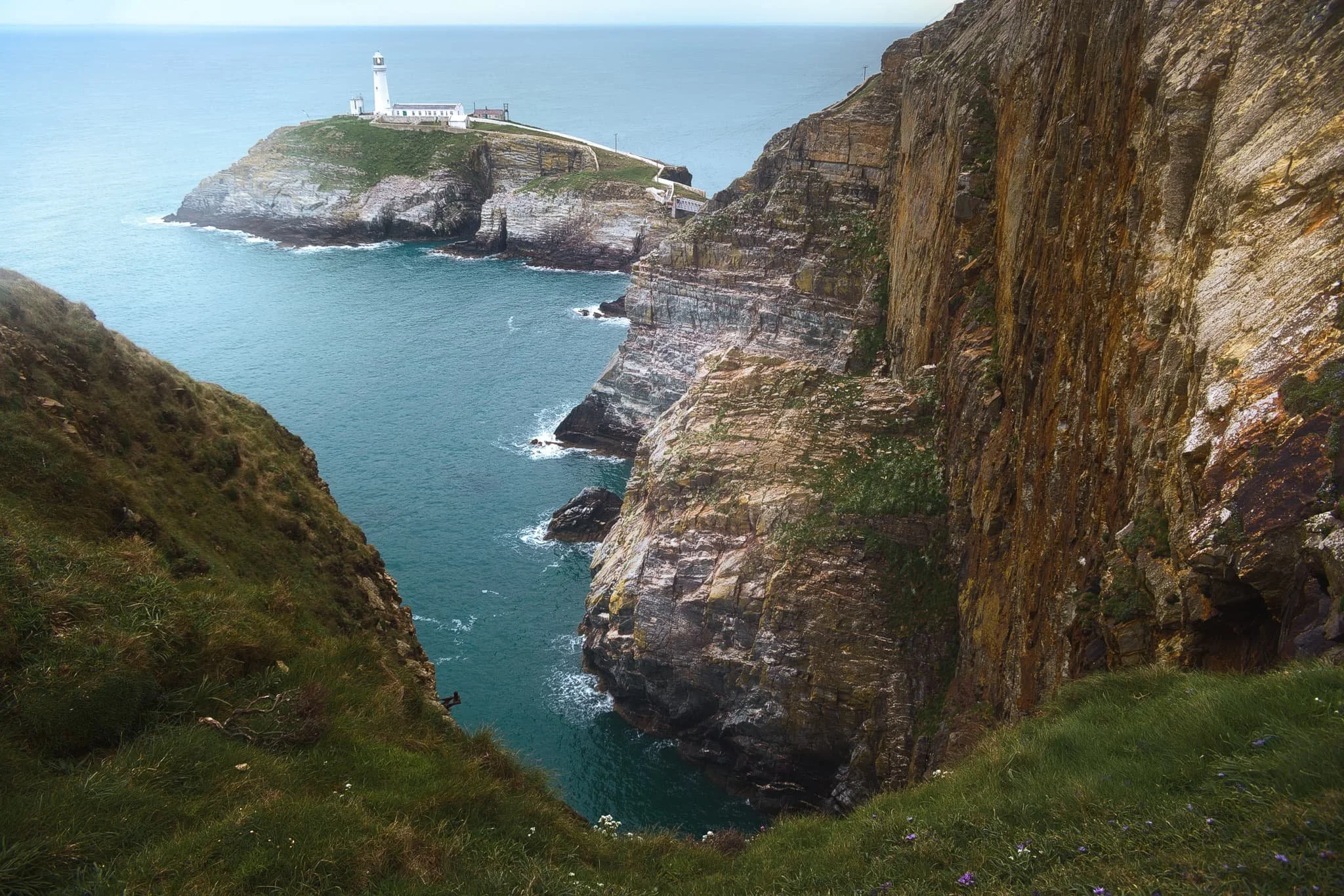
After circumambulating around Rhoscolyn Headland, we drove further up the coastline of Ynys Gybi to revisit a favourite of ours: South Stack. This is a tiny rocky island just off the cliffs of Ynys Gybi, and is home to a picturesque lighthouse. Access is via steep and winding steps that navigate down the sheer cliff face. Every now and then, you get incredible views across the cliffs as you head down the steps.
South Stack lighthouse, shot from higher up the steps. The lighthouse was constructed in 1809 and finally automated in 1983. To begin with, the sole means to traverse to the island was via a basket hung from a hemp rope. Subsequently, in 1828 an iron suspension bridge was constructed, which was then replaced in 1964 by a steel cable truss bridge. Nevertheless, in 1983 it became necessary to close the bridge to the public due to safety issues. Finally, after an aluminium bridge was built, the lighthouse was reopened for public access in 1997. At present, it has become a favoured tourist attraction, drawing many thousands of visitors annually.
Further south from the lighthouse, one can take the path from the RSPCB building down the cliff to Ellin’s Tower, then enjoy a wander along the cliff tops there. A sheer from near Ellin’s Tower gave me this dramatic composition looking back at South Stack and its lighthouse.
Elin’s Tower and, further, South Stack Lighthouse in the distance, with gorse (Ulex europaeus) flowering everywhere. Unusually, gorse in the spring has the strong scent of coconut. Elin's Tower is a Victorian stone tower. This castellated architectural extravagance, initially employed as a summer residence, was constructed between 1820 and 1850 for the prominent Stanley family of Penrhos. It derives its name from Elin (anglicised as "Ellen"), the Welsh spouse of the 19th-century statesman William Owen Stanley.
Did you enjoy these photos?

Llansteffan, Carmarthenshire, South Wales, Autumn
Did you know that Wales is home to the most castles per square mile of any country in Europe?
Did you know that Wales is home to the most castles per square mile of any country in Europe?
Certainly during our stay in South Wales we visited our fair share of them, mostly in ruins, such as Dinefwr and Castell Carreg Cennen, and Llandovery castle.
Heading south towards Carmarthen Bay, where the Avon Twyi pours out into the Bristol Channel, one can find the sleepy little village of Llansteffan with yet another magnificent fort perched on a cliff top overlooking the bay. The village’s name means “Llan of St. Stephen”. You’ll find a lot of place names in Wales start with the prefix Llan; it refers to sanctified land occupied by Christian monks or communities, almost always named in honour of a Saint.
After checking out the ruins of Llansteffan Castle, we ambled along the beach below the castle, where I gawped and photographed the local geology.
All photos shot on my Fujifilm X-T2 using my Vivitar “Series 1” 28–105mm f2.8–3.8 zoom and Laowa 9mm f2.8 prime lenses. RAWs converted in Capture One for iPad, then developed and finalised in Affinity Photo for iPad.
Llansteffan, Carmarthenshire, South Wales, Autumn by Ian Cylkowski is licensed under CC BY-NC-SA 4.0![]()
![]()
![]()
![]()
A rather shapely tree that caught my eye on the way up to Llansteffan Castle.
From outside the castle ruins the views overlooking Carmarthen Bay were rather splendid.
The ruins of Llansteffan Castle. It sits on the site of a much older Iron Age fort, showing that Llansteffan has been inhabited for millennia.
The Normans built a castle here in the 12th century. Like a lot of castles here in South Wales it passed hands often between the Welsh and the English. By the 14th century it was described as being in a poor state.
One thing that struck in particular about these ruins were all the wasps. They were everywhere, tucked into various nooks and crannies of the stonework.
We braved the disconcerting hum of wasps all around us to explore this building for a composition whilst the light was particularly sympathetic.
Down on the beach below the castle, things were thankfully a lot more peaceful.
Historical glaciation and millennia of coastal erosion from the sea have exposed millions of years of geology history. Here Llansteffan would’ve been at various times a desert, at the bottom of a sea, and everything in between, with different rocks forming and deposited at various stages. Fascinating.
To quote Natural Resources Wales: “The bedrock geology of this area […] is dominated by Devonian Old Red Sandstone characterised by mudstones, siltstones, sandstones and conglomerates which were deposited in fluvial environments, such as meandering channels and floodplains. The rocks around Llansteffan include important exposures of calcrete (which is a fossil soil indicative of an arid or semi-arid environment). Overlying the Old red Sandstone is a classic sequence of Carboniferous rocks including shallow-marine carbonates (Carboniferous Limestone), shallow-marine and fluvio-deltaic deposits (Millstone Grit), and lacustrine, delta plain sediments and coal (Coal Measures).”
The exposure of Old Red Sandstone is clearer towards Scott’s Bay, where plenty of people were chilling with their pets, nestled into the crags.
I was beguiled by the shapes, forms and colours of the cliff rocks. Imagining the millions of years of this land, and how different the local landscape would’ve looked, makes my head spin!
A tighter composition reveals the joins and seems of various types of rocks as beautiful late afternoon light highlights the textures.
Llansteffan Castle and its dominating position above the village and the surrounding farmland.
Did you enjoy these photos?
North Pennines Waterfalls, County Durham, Summer
Woohoo for a week off! With the Lake District as rammed as it is at the moment, let’s go somewhere a l’al bit different.
Woohoo for a week off! With the Lake District as rammed as it is at the moment, let’s go somewhere and l’al bit different.
The North Pennines AONB (Area of Outstanding Natural Beauty) is a favourite of ours but remains relatively untouched by us. We’ve explored arguably the jewel of the North Pennines, High Cup Nick, many times. But another absolutely stunning part of the area is the three main waterfalls: High Force, Low Force, and Cauldron Snout.
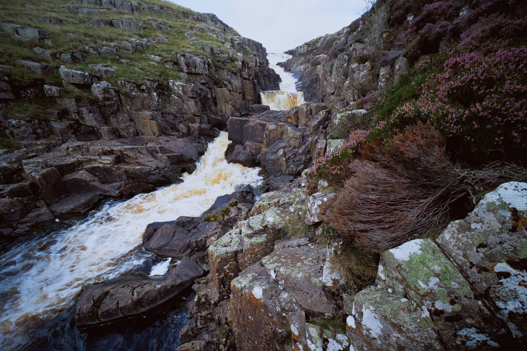
Long-time followers of this blog may remember our last excursion to High Force and Low Force, last year. The two waterfalls are a geology student’s dream and truly spectacular. But the third waterfall, Cauldron Snout, is often missed out on compared to the other two. That’s because it’s many miles further up the River Tees, near Cow Green Reservoir. Like High Force and Low Force, Cauldron Snout is the result of the outflow of Cow Green Reservoir passing over the whin sill; a layer of prehistoric super-hard dolerite volcanic rock that has left pillars and columns. The waterfall has eroded the softer rock around, leaving the harder columns of whin sill standing.
Cauldron Snout “only” drops about 60 m, all in all, but does so steeply down 180 m of the gorge, making it one of the longest waterfalls in England. The last time we visited it was many years ago in between Christmas and New Year, and a lot of the rock around the waterfall was covered in ice, making it a treacherous task to navigate. This time, we managed to scramble all the down alongside the waterfall. It was immense.
All photos shot on my Fujifilm X-T2 using my three prime lenses: a Samyang 35mm f/1.2, a Laowa 9mm f/2.8, and an adapted Pentax SMC 55mm f/2.0. Images developed using one of RNI Film’s Kodachrome profiles, finished in Affinity Photo.
Low Force is probably the easiest of the three to access, being less than a kilometre’s walk from the Bowlees Visitor Centre. Regardless, it’s an impressive sight and sound.
My lovely Lisabet, already on the case and getting some compositions in.
I clambered around the columns and cliffs of whin sill to get to the northern bank of the Tees for this view of the main falls of Low Force. The morning’s light was wonderful and I didn’t want to miss out.
The twin falls of Low Force. Not necessarily all that tall, but powerful and loud.
The conditions and light were beautiful. Not too harsh. Autumn’s definitely on the way.
One gentleman decided that a dip in the waterfall was in order.
Fair play to him.
The Pennine Way heads along this footbridge, which crosses the River Tees below. It’s an old ‘un, too, so all the signage requests people cross it one at a time.
The lower aspect of Low Force shot from the southern banks of the Tees after we crossed the bridge.
After I spotted this young lass climbing the statues, I think she looked rather… sheepish?
A tighter composition of the main falls of Low Force, trying to convey the sheer power of these waterfalls. The redness in the water comes from all the peat the river carries from the high moorlands of the North Pennines.
Looking back at the northern bank of the River Tees, with more people finding their now to the waterfalls. Best get a move on.
Lisabet doing her best to capture all the splendour around her.
Love all the signs of autumn starting to appear.
Looking forward to all the rusty colours of autumnal ferns.
After trekking the Pennine Way along the southern side of the River Tees, we crossed another old footbridge and took these steep steps up towards the road. A visit to High Force beckoned us.
The woodland above the Tees is still lush.
After paying our entrance fee (£2 per adult, very reasonable), we followed the path through the woodlands of the Raby Estate. Already, we could hear the booming sound of the giant waterfall, High Force.
The first glimpse of High Force and the gorge it’s created. The excitement builds…
And there she is, plunging 70 ft off a cliff into the deep pool below. What a sight.
We scrambled down to the boulder field left behind by the receding waterfall, each of us seeking our own photographic compositions of the waterfall.
Of course, mine predominately featured all the wonderful shapes of the boulders.
After thousands and thousands of years, as the waterfall carves its way back up the River Tees, it’s left behind boulder with fascinating shapes and textures.
Plenty of other folk were clambering around the boulders for better views of the awesome High Force.
Nature makes you feel closer.
Due to the COVID-19 Pandemic, the High Force trail is a one-way system now, so we hiked up the steep steps out of the gorge and navigated through the Raby Estate woods back to the car. My lovely Lisabet, looking as stunning as ever.
Upper Teesdale has a similar “feel” to a Yorkshire Dales valley, to me.
After a break for lunch, we drove a few miles west and parked at Cow Green Reservoir, seeking out Cauldron Snout. Along the way, views across the reservoir can be had of Meldon Hill (767 m/2,517 ft).
We crossed the dam for views over the reservoir and below to the Tees. Clouds of midges were out in full force.
Looking down onto the Tees from the top of the dam. You can just make out to the left the top of Cauldron Snout before it crashes down into the valley.
Cow Green Reservoir was constructed in the late 1960s to supply the industries of Teeside with a constant supply of water.
The reservoir essentially acts as a river regulator, ensuring the River Tees is always flowing with water even during dry conditions.
And here’s the top of Cauldron Snout. The Pennine Way is to left, but it isn’t really a “path” as such as navigating and scrambling down the side of the gorge created by the waterfall.
But doing so enables you to get right next to the falls for cracking views like this. A man perched at the top of the falls helps provide a sense of scale.
With the heather in bloom, they provided wonderful pops of colour around the waterfall.
Scrambling down the gorge was exhilarating, and definitely something that would not have been possible for my condition 5-years ago.
As the gorge sheltered us from the wind, this provided the necessary moist and still conditions for clouds of midges to form everywhere. They duly took advantage and started ravaging our bare flesh.
Near the bottom of Cauldron Snout now, and we can start to understand the scale of these falls.
The bottom of Cauldron Snout, which climaxes with this beautiful fanned curtain of a waterfall.