Trollers Gill & Parcevall Hall, Yorkshire Dales, Spring
Happy belated Easter everyone. Did you have a good 'un?
Happy belated Easter everyone. Did you have a good 'un?
Usually for Cumbria, and the Lake District in particular, Easter signals the first tourism wave of the season. With that in mind, and no obligations to serve, Lisabet and I booked a couple of nights away in a beautiful B&B set in bonny Pateley Bridge, in the Nidderdale Area of Outstanding Natural Beauty.
We took the scenic route to Nidderdale from Cumbria, as we didn't need to check in until the evening. So, first we stopped off at the impossibly pretty Yorkshire Dales village of Burnsall for lunch and some light photography. Afterwards we continued east and stopped off near Grimwith Reservoir for the day's main activity: Trollers Gill.
This place has been on my radar, otherwise known as my Pinterest, for years.
It did not disappoint.
All photos shot on my Fujifilm X-T2 using my three prime lenses: a Fujinon 23mm f/2.0, a Laowa 9mm f/2.8, and an adapted Pentax SMC 55mm f/2.0. Images made 80% in-camera using the Astia film simulation, then finished off in Lightroom and Affinity Photo.
Burnsall
After coffee and a bacon butty near the river, we snapped some shots of Burnsall as we made our merry way back to the car. The 5-arched Burnsall Bridge here is a Grade II listed building, originally constructed in the 17th century with some 19th century improvements.
I'm not sure it's possible to get more Yorkshire than this scene. The Red Lion, built in the 16th century, and recently taken over by Thwaites Brewery.
Like many Yorkshire Dales villages, there's plenty of historical sandy limestone buildings decorated with beautiful greenery, flowers, and the distant hills.
Burnsall Primary School. Originally the old Grammar School founded in 1602 by William Craven of Appletreewick, who later became Lord Mayor of London.
Trollers Gill
After Burnsall, I identified a handy little parking area off the B6265 that would serve as the starting point of our hike to, and up, Trollers Gill. The day was bright and sunny whilst also hazy, lending a wonderful sense of intrigue and distance to photographs. Up on the moorland high above Appletreewick, views extended for miles and miles.
The path down the moorland was easy enough to follow, and soon the characteristic karst limestone landscape of the Yorkshire Dales became apparent.
The main signs pointing to Trollers Gill invite walkers to enter the ravine at the top and scramble their way down. Instead, we elected to take the trail around the western side of Middle Fell. This would eventually lead us to the bottom of Trollers Gill.
The anticipation and excitement builds as we near the bottom of the deep ravine.

At the bottom of Trollerdale, we followed the minor path north to start the climb up Trollers Gill. But first, I simply had to snap this glorious scene.
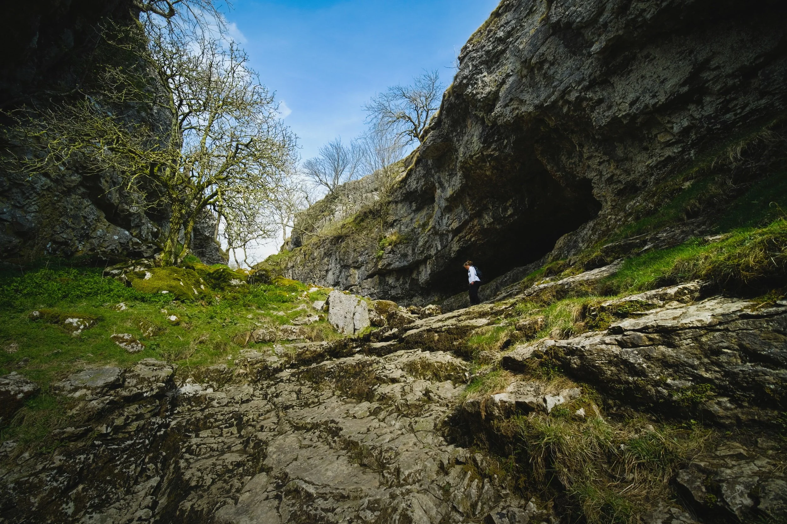
The entrance to Trollers Gill, largely dry for most of the year. Historically this would've been the site of a thunderous ravine with several waterfalls and cascades crashing down the gill. Thousands of years of erosion in a limestone landscape means the beck at the top of the gill now goes underground before entering the ravine, later reemerging at the bottom of Trollerdale.
Looking back at our way into Trollers Gill. Fellow hikers gingerly navigate the way down the ravine. Can you imagine this gorge full of water?
As with many other places in the Yorkshire Dales that features sheer limestone walls, Trollers Gill is a favourite for rock climbers.
Rock climbers assist each other as they ascertain routes up the sheer sides of Trollers Gill.
An ultra wide composition looking up from the bottom of what would've been a powerful waterfall. The meaning of the name "Trollers Gill" comes in two parts. "Gill" is already quite well known and used in Yorkshire and Cumbria, sometimes alternatively spelled as "Ghyll". It means a deep ravine or gully, and is cognate with the word gullet. "Trollers" is split into two: "troll" meaning, well, troll, the mythical beast (not the internet variety), and ears meaning "arse". This gives us "the Troll's arse". You're welcome.
Near the top of Trollers Gill, where the beck mysteriously disappears into the unfathomably twisted caves underneath.
Climbing out the gill and up onto the moorland, we realise that the haze has nearly cleared, giving us a fairly clear shot of Simon's Seat.
The deep drop into Trollers Gill that we had just climbed out of.
The single lane "New Road" that connects with the B6265.
A clear sign that a moorland is particularly and consistently wet: rushes everywhere.
One last look back at the farm track that guided us down into Trollers Gill.
A great discovery! Hanging on a branch near our parking spot was this beautifully preserved sheep's skull, probably a Swaledale. We took it home. Isn't it beautiful?
Parcevall Hall & Gardens
After returning to the car, we realised looking at the map that we were very near Parcevall Hall & Gardens. Fancy a quick visit and a wander? Why not?
Parcevall Hall is a Grade II listed Manor House that includes 24 acres of sculpted and maintained gardens. They were created in 1927 but fell into decline after 1960 following the death of Sir William Milner, 8th Baronet of Nun Appleton. Restoration work commenced in the 1980s.

People can visit and explore the gardens between April and October. It enjoys fabulous views and beautiful displays.
Lisabet and I particularly enjoyed this peaceful statue.
The Gardens, amongst other things, are known for their wonderful view of Trollers Gill, so we followed the route uphill.
Still plenty of daffodils around.
And there it is. Trollers Gill to the right and Middle Fell in the centre, daffodils blooming below. What a fantastic scene.
Cherry Blossom in full bloom at the entrance to the Gardens. What a full and gorgeous day.
Howgills, Yorkshire Dales, Summer
It was time to come back to the Howgills.
It was time to come back to the Howgills.
Back in April this year, 2021, Lisabet and I made our first hike up onto the Howgills, summiting Winder (473 m/1,552 ft), the fell that directly overlooks the beautiful Yorkshire Dales town of Sedbergh. It wasn’t hard, during that hike, to gawp at the next fell along the ridge from Winder, namely Arant Haw at 605 m. We vowed to return and tackle Arant Haw.
Today was that day.
The forecast was for clear skies and pushing 20°C, but when we arrived at Sedbergh for around 9am it was relatively chilly and cloudy. As we began our ascent up the Dales High Way up into the Howgills—and the views opened up—it became apparent that the cloud base still hadn’t quite cleared the fell tops. This resulted in amazing light and weather conditions, significantly slowing down our hiking progress (but all for good reason).
After a proper good pull, we managed to summit Arant Haw as well as add on the smaller fell of Crook on the way back down.
What a crackin’ day.
All photos shot on my Fujifilm X-T2 using two of my prime lenses: a Samyang 35mm f/1.2 and a Laowa 9mm f/2.8. Developed with RNI Films’ Kodak Portra 160 profile.
The way marker indicates the Dales High Way, the main trail that takes you up into the Howgills from Sedbergh. The fell on the left is Crook.
This was the kind of light show we were subject to on our way up the Howgills. The cloud base was clinging to the top of the Garsdale and Dent fells, and as the sun was rising they were swirling as they burning off.
Shapely Winder from the Dales High Way. Not our destination for the day.
A fell runner and her anxious dog passed us on their way across Settlebeck Gill and up Crook.
Plenty of lambs and young sheep around the Howgills, warily watching us we disturbed their grazing.
It wasn’t long before we spotted more people heading up the trail behind us. We weren’t in a rush. The light and views were too good to miss.
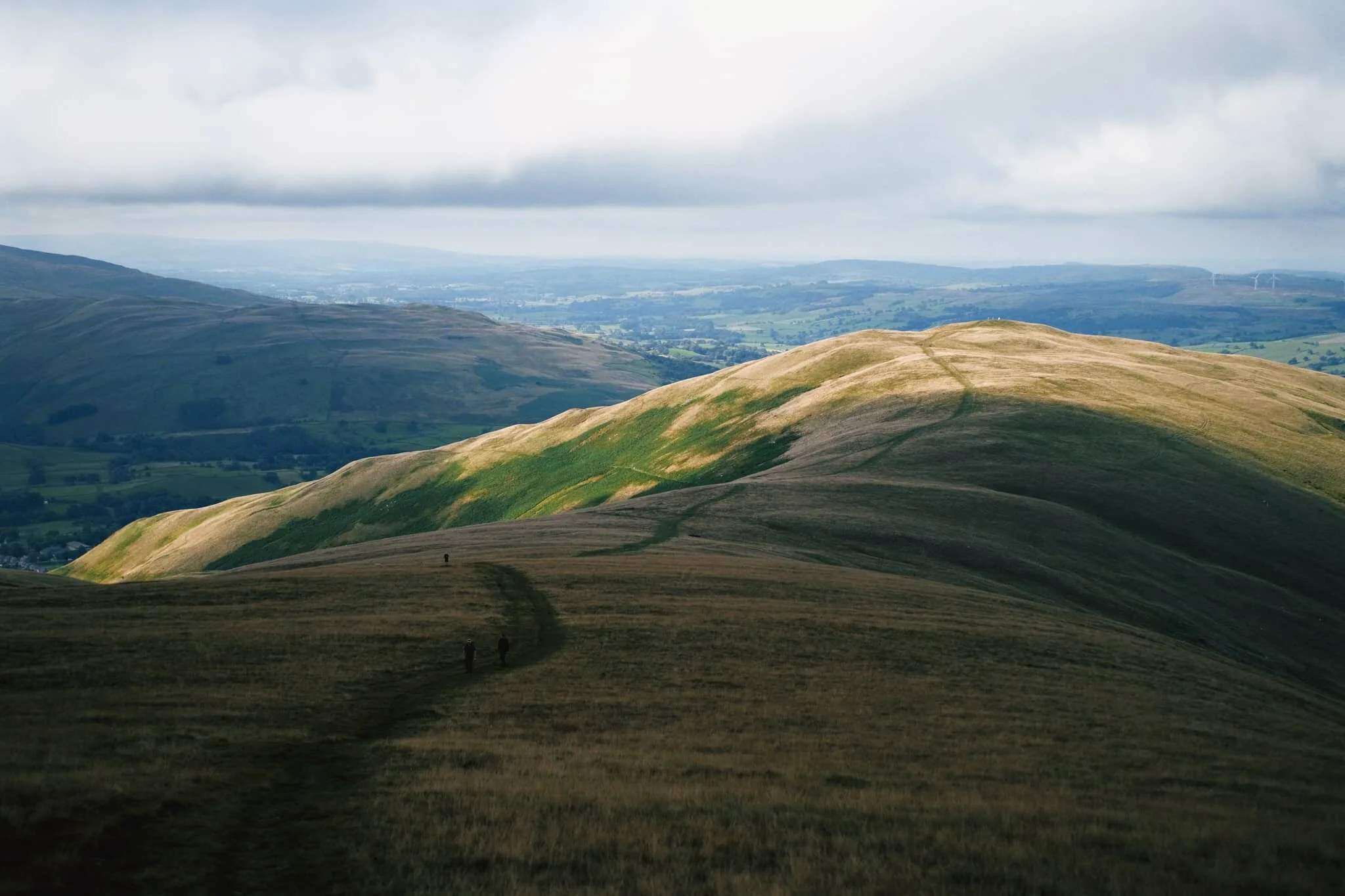
The view looking up Settlebeck Gill. That little hill in the distance with the trail running over it? That’s our destination: Arant Haw.
Looking down Settlebeck Gill, the light and views just get better and better.
The small Frostrow Fells catching the morning light, whilst the Dent fells recede in shadow. Astounding.
The steep folds of Settlebeck Gill, leading down to Sedbergh and the Barbondale fells beyond.
After reaching the plateau above Settlebeck Gill, our destination becomes immediately obvious: Arant Haw.
Looking back to Winder, morning light scanned across the fells and I waited for it to reach the summit of Winder before snapping this composition.
The view north from the summit of Arant Haw. Good heavens.
The views north from Arant Haw take in a succession of Howgills peaks and valleys, felltops such as Calders (674 m/2,211 ft), Bram Rigg Top (672 m/2,205 ft), The Calf (676 m/2,218 ft, highest point of the Howgills), and White Fell (636 m/2,086 ft). The clouds clung to the felltops as the day brightened
Looking down the gill of Swarth Greaves Beck eastwards. Views for miles and miles.
Just astounding.
The western spur that juts out from Arant Haw gives you an indication of the steepness of the fell’s western face.
Zooming in more, I love this arrangement of horizontal and diagonal lines created by the fells and gills.
Time to head down Arant Haw. The conditions looking back to Winder and Sedbergh were starting to brighten up significantly.
The little knobbly fell to the right is our next destination: Crook. There’s not any “official” path to the fell, but that’s no major bother anyway. The Howgills is all Open Access Land.
Swaledale and Rough Fell sheep enjoy the views towards Garsdale as much as we do, it seems.
Even though Crook is only 450 m high or so, the views from its summit are no less impressive.
From Crook it was even possible to make out the back of Wild Boar Fell in Mallerstang, looking northeast.
Looking back up to Arant Haw from around Crook summit, the light getting brighter and brighter.
It was time to come off the Howgills, Lisabet leading the way ahead. We decided on the Soolbank route off Crook, heading down into Settlebeck Gill.
Once we were alongside the banks of Settlebeck Gill, it was simple enough to follow the gill all the down until you could cross and rejoin the Dales High Way back into Sedbergh.
Settlebeck Gill is an impressive sight. The little people hiking the Dales High Way give an indication of scale.
The way back down into Sedbergh, the fells now free of clouds.