Clougha Pike, Forest of Bowland, Lancashire, Summer
The last few weeks have been… tough.
The last few weeks have been… tough.
Not long after our hike to and around Stockghyll Force, I managed to acquire some form of vertigo for a few days, which was decidedly unpleasant. The following week, my lovely Lisabet came down with a rather nasty summer cold, and I managed to fall down the stairs, spraining my wrist and severely bruising my butt. Then the week after, I caught Lisabet’s cold.
Yeesh.
Finally though, we were both fit and healthy, ready to get back out in nature. Following wise counsel from our nature expert friend, Andrew, we embarked on a completely new hike for us: the Clougha Pike circular.
Clougha Pike is the westernmost summit in the Forest of Bowland Area of Outstanding Natural Beauty. Many peaks in the Forest of Bowland are gristone fells surrounded by heather-covered peat moorland, blanket bog, and deep wooded valleys. Clougha Pike is no different, though its southern face drops away dramatically to the valley floor, and is clearly visible from most areas around Lancaster.
I ended up being in rather a lot of pain for this 10km hike. For reasons unknown to me, I slowly developed a blistering headache as the hike went on. This was paired with a sore neck (from having to look down at my footing a lot), sore knees (an every day occurrence), and painful feet (soles in my boots are now too thin).
Oh also, around the lower areas of the walk, having to deal with all the sheep flies and deer flies.
Despite all of this, the hike was gorgeous. The heather was in full bloom, covering the land and fells in carpets of mauve flowers. We were also experiencing the tail end of Storm Betty, so the higher we ascended the more the 50 mph winds punched our bodies.
All in all, it made for an epic day, and crackin’ photos.
Photos taken on my Sony α7ii using my Sony FE 28–70mm f3.5–5.6 OSS zoom lens. RAWS developed in Lightroom for iPad using RNI Films’ Fortia SP film emulation, then finalised in Affinity Photo 2 for iPad.
Clougha Pike, Forest of Bowland, Lancashire, Summer by Ian Cylkowski is licensed under CC BY-NC-SA 4.0![]()
![]()
![]()
![]()
Just a few yards from the car park and already we could see the extent of all the pinky purple heather blooming in the area.
This trail is the more direct route up to Clougha Pike. But for our hike, we chose a more circular clockwise route, skirting around the old quarries and heading towards Littledale.
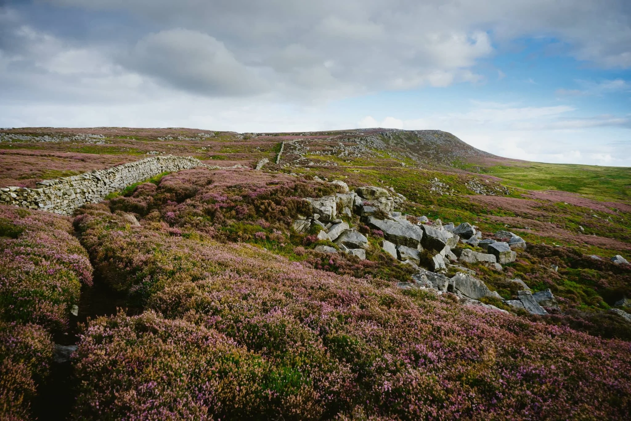
The colour contrast between the heather and the grasses was proving too hard to resist.

A small scene of a gristone boulder being enveloped by all the heather, fern, and other moorland vegetation.
Increasingly I delight in finding, composing, and shooting these more intimate scenes in nature.

Miles upon miles of heather moorland give way to the lower folding valleys near Quernmore.
This point marked the beginning of our ascent of the fellside above Littledale, the site of a former quarry.
After crossing the infant River Conder via a concealed viaduct now known as Ottergear Bridge, we continued ascending the fellside above Cragg Wood. In the distance, Caton Moor’s windfarm catches the emerging light.
The trail gently lowered back down the fellside, but not before I captured this delightfully bucolic English view.
Another ascent ahead of us, the time the proper one that takes us all the way up to the Clougha Fell moorland plateau. The cascades of Sweet Beck presented a lovely little composition.
A swaledale yew enjoys the view from the fellside above Sweet Beck, with Caton Moor still drenched in light.
As we start ascending the back of Clougha Fell, the greens of the grass is gradually replaced the pinks of heather and the dark tones of peat, punctuated with boulders of gritstone.
The Caton Moor windfarm still getting soaked in afternoon light. In the distance, the dark clouds press down on the southwestern fells of the Yorkshire Dales.
After tacking the tricky and occasionally boggy trail up the back of Clougha, we finally joined the gravel shooter’s track and the moorland plateau. Rather then heading straight for the summit, we looped around to check this Andy Goldsworthy sculpture.
Of course, we had to take turns clambering into the “chambers” for some photos. The nice thing is, in the 50+ mph winds, these chambers were a nice respite from being constantly wrestled by the wind.
Making our way onto Clougha Fell, I had lots of fun making compositions from all the gritstone formations dotted about everywhere, such as with these boulders and the Yorkshire Dales Three Peaks in the distance.
A gritstone platform with solitary boulders, wrapped in heather, provided a nice scene towards Caton Moor and the dark fells in the distance.
It’s not quite Joe Cornish levels of composition skill, but I’ll get there one day.
A solitary gritstone boulder perched on the moorland plateau serves as a nice subject as it catches the light beneath the stormy skies.
From the summit of Clougha Pike, a mere 413 m/1,355 ft above sea level. Nevertheless, the views are gorgeous. From the summit we can see all the way across the Lune valley, towards Morecambe Bay.
From the summit, our way back down was immediately apparent. It was going to be rocky and steep.

100 m or so below the summit of Clougha Pike, a patch of smoothed gritstone boulders interspersed with heather provide me with another tasty composition.
From below Clougha Pike’s southern face, it’s easy to see how this is such a distinct and recognisable hill from many miles away.
A blast of light from the racing stormy clouds pulls all the gorgeous textures and colours from this scene.
One last look back at Clougha Pike, with heather everywhere, but we continued the descent down into the woodland toward the car park, fighting flies all the way.
Did you enjoy these photos?

Walla Crag, Lake District, Summer
A 4am start.
A 4am start.
The UK is on the cusp of a record-breaking heatwave, kicking in Sunday evening/Monday morning. Even before the real heatwave arrived, Sunday’s temperatures up here in Cumbria were looking to peak at around 26°C. Not only that, summer in the Lake District is easily its busiest time. So what to do?
Wake up before the sun rises and get to our destination before everyone else.
We decided on revisiting the small Walla Crag above Derwentwater, a new favourite after our first venture in autumn last year. Upon leaving the house we were greeted with something we didn’t expect before a heatwave, but probably should’ve anyway.
Rain.
We pulled up at the parking spot, and thankfully it only took 15 minutes or so for the rain to cease. By about 6:40am we started the walk up to Walla Crag.
Although the rain had cleared, it was still completely overcast even as temperatures quickly rose. The sun was not able to break through. So although light conditions were not the best, the views were still utterly magnificent.
All photos taken on my Fujifilm X-T2 using my Vivitar “Series 1” 28–105mm f2.8–f3.8 zoom lens. Shot using the Classic Chrome film simulation, developed in Capture One for iPad, cleaned up in Affinity Photo for iPad.
Walla Crag, Lake District, Summer by Ian Cylkowski is licensed under CC BY-NC-SA 4.0![]()
![]()
![]()
![]()
Across the fields from the Walla Crag path, Low Rigg looks diminutive against the imposing crag face of Clough Head, part of the Helvellyn range.
As we began the steep ascent up to Walla Crag, the views looking back opened up quickly. Here, Blencathra’s beautiful shape is unmistakeable.
The way up to Walla Crag, a short and sharp ascent.
Once up on the more level part of the fell, a small gate through the drystone wall allows you to take the more exploratory route to Walla Crag’s summit. Near the crag’s cliff edge, clear panoramas can be enjoyed across Derwentwater to the Grisedale fells.
Back along the cliff edge towards Blencathra, already there is some heather starting to appear. Give it another month or so for it to be in full resplendent bloom.
The smooth multi-peaked profile of Skiddaw, England’s 6th highest peak.
Walla Crag’s cliff face is lush, chock-full of fern, trees, heather, and loads of other flora. Lisabet discovered a small bilberry bush, and helped herself to a couple of the tart berries.
The summit of Walla Crag! Looking back north towards Skiddaw, a dominant presence on the Keswick skyline.
Derwentwater looks dry, with a couple of new islands becoming exposed as the water level drops.
One final composition from the summit, this time featuring Blencathra’s curved forms.
Walking towards the Jaws of Borrowdale.
Probably my favourite composition of the day. The drystone wall keeps livestock out of the Walla Crag area, allowing flora to flourish. In the distance is Derwentwater’s southern tip with the Borrowdale fells high above.
The other side of the same wall, featuring more of the Catbells ridge.
On the way back down the fell, I couldn’t resist revisiting this composition.
Pretty happy with how this shot of a family of fell ponies came out.
Did you like these photos?
Walla Crag, Lake District, Autumn
Autumn has arrived.
Autumn has arrived.
The “life” from all the verdant vegetation is starting to wane, the ferns are turning rust-hued, and the leaves are beginning to drop. Autumn’s here, and I cannot wait for those autumnal colours.
Whilst we wait, we decided today on a venture up a relatively small fell that we’ve never tried before: Walla Crag (379 m/1,243 ft).
At “only” 379 m tall it’s definitely one of the smaller fells, especially when compared to some of the giants in the area such as Skiddaw (931 m/3,054 ft) and Blencathra (868 m/2,848 ft). Nevertheless, what it lacks in height it makes up for in the jaw-dropping views it offers from its summit.
All photos shot on my Fujifilm X-T2 using my three prime lenses: a Samyang 35mm f/1.2, a Laowa 9mm f/2.8, and an adapted Pentax SMC 55mm f/2.0. Developed using RNI Films’ Kodak Ektar 100 profile.
Not far along the trail and already the views really open up. A couple enjoy a picnic in the sun with the backdrop of the Helvellyn fells behind them.
A row of Roman trees, Sorbus aucuparia, filled with their fruit frame the trail looking back to Blencathra in the distance.
The trail starts rising, offering up views looking back towards the likes of Lonscale Fell (715 m/2,346 ft).
By now the full profile of Skiddaw, its fells, and the smooth profile of Latrigg are fully exposed. It’s turning out to be a crackin’ day.
Plenty of other fell walkers were making their way up and down the trail. To the left in the distance is the magnificent slopes and peaks of Blencathra.
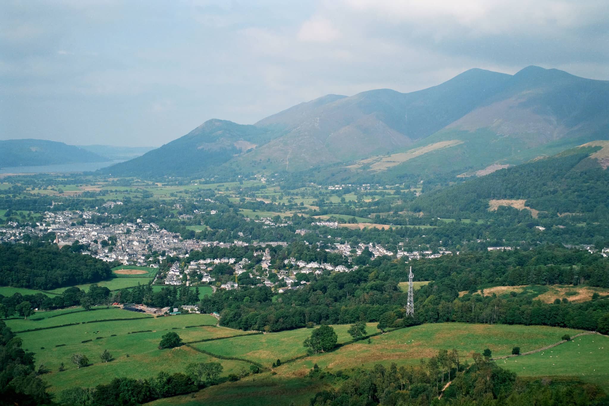
Skiddaw’s multi-peak shape looms of the bonny town of Keswick.
On our way up, the views towards the Derwentwater Fells, too, soon open up and our sense of anticipation grows.
Rowan trees and their vivid berries frame the Derwentwater fells on a somewhat hazy day.
Another lovely aspect to Walla Crag’s environment is the sheer abundance of pink heather everywhere.
The water level at Derwentwater is ridiculously low. New gravelly islands are reappearing and existing ones are gaining new shores.
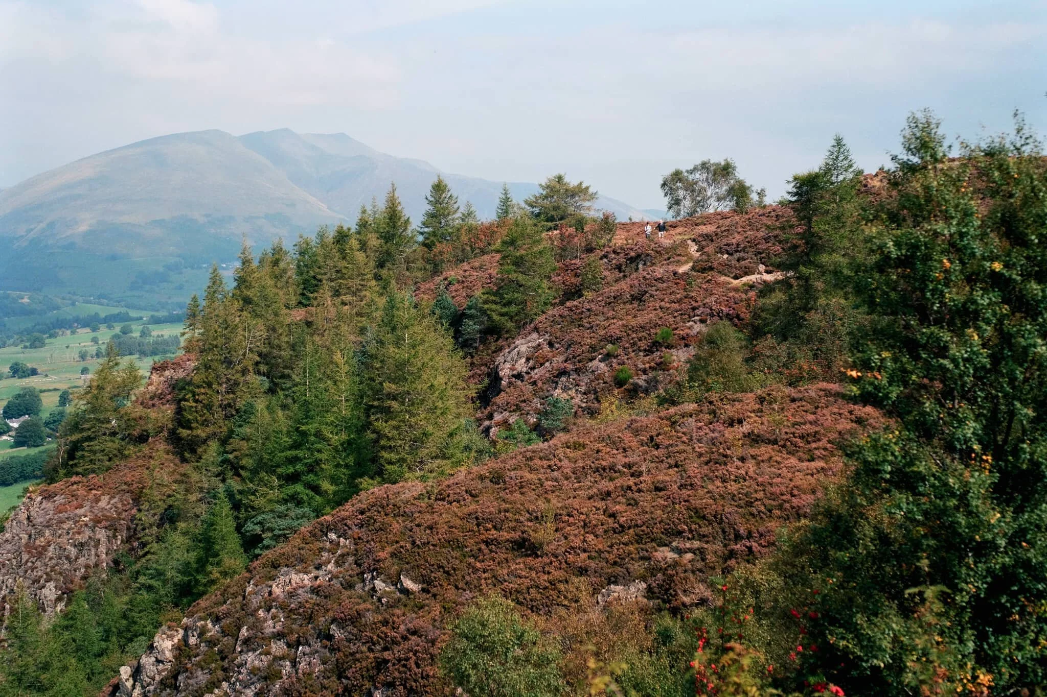
It soon becomes apparent how much of a drop there is from Walla Crag’s northwestern face.
As more sun comes out, I spot another framing opportunity full of colour.
Looking back at the cliff-edge trail we followed. The amount of heather around Walla Crag is ludicrous.
Like, so much heather…
Aaaand… summit! Plenty of other folk enjoying the views from Walla Crag summit too. We stop for a quick bite and some water, taking the panorama in.
My ultra-wide 9mm lens was able to take in the vast panorama available from the summit of Walla Crag. One of the best views in the whole of the Lake District.
With my 55mm attached, it was time to pick out some smaller scenes amongst the vast panorama. The hazy conditions allowed for a wonderful layering affect with Derwentwater Fells.
Mighty Skiddaw looming above Keswick.
After taking everything in, it was time to follow the trail back down from the summit towards the main path off Walla Crag, with heather still in abundance.
Looking across the moorland and ferns, deep into the Jaws of Borrowdale.
Fellow hikers branch off from the path to take in the views towards the Helvellyn range, and Clough Head (726 m/2,382 ft) in particular.
Seemingly endless layers of fells in Borrowdale.
On the way back down off the fell, I spot this tree and arrange it underneath the peaks of Blencathra.
Magnificent Blencathra, demanding our constant attention as we climb off the shoulders of Walla Crag.
This is Armillaria mellea, or honey fungus. Apparently highly revered for its edible qualities, though a lot of UK species react with alcohol badly in people’s bodies causing nausea and vomiting. It’s generally best to parboil these mushrooms, and not consume alcohol for a day before and after eating them.
Follow other hikers along the trail back down to the car. The haze appears to lift somewhat around the Helvellyn fells.
The Helvellyn range above, with High Rigg and Low Rigg below.
Another fantastic day.
North Pennines Waterfalls, County Durham, Summer
Woohoo for a week off! With the Lake District as rammed as it is at the moment, let’s go somewhere a l’al bit different.
Woohoo for a week off! With the Lake District as rammed as it is at the moment, let’s go somewhere and l’al bit different.
The North Pennines AONB (Area of Outstanding Natural Beauty) is a favourite of ours but remains relatively untouched by us. We’ve explored arguably the jewel of the North Pennines, High Cup Nick, many times. But another absolutely stunning part of the area is the three main waterfalls: High Force, Low Force, and Cauldron Snout.
Long-time followers of this blog may remember our last excursion to High Force and Low Force, last year. The two waterfalls are a geology student’s dream and truly spectacular. But the third waterfall, Cauldron Snout, is often missed out on compared to the other two. That’s because it’s many miles further up the River Tees, near Cow Green Reservoir. Like High Force and Low Force, Cauldron Snout is the result of the outflow of Cow Green Reservoir passing over the whin sill; a layer of prehistoric super-hard dolerite volcanic rock that has left pillars and columns. The waterfall has eroded the softer rock around, leaving the harder columns of whin sill standing.
Cauldron Snout “only” drops about 60 m, all in all, but does so steeply down 180 m of the gorge, making it one of the longest waterfalls in England. The last time we visited it was many years ago in between Christmas and New Year, and a lot of the rock around the waterfall was covered in ice, making it a treacherous task to navigate. This time, we managed to scramble all the down alongside the waterfall. It was immense.
All photos shot on my Fujifilm X-T2 using my three prime lenses: a Samyang 35mm f/1.2, a Laowa 9mm f/2.8, and an adapted Pentax SMC 55mm f/2.0. Images developed using one of RNI Film’s Kodachrome profiles, finished in Affinity Photo.
Low Force is probably the easiest of the three to access, being less than a kilometre’s walk from the Bowlees Visitor Centre. Regardless, it’s an impressive sight and sound.
My lovely Lisabet, already on the case and getting some compositions in.
I clambered around the columns and cliffs of whin sill to get to the northern bank of the Tees for this view of the main falls of Low Force. The morning’s light was wonderful and I didn’t want to miss out.
The twin falls of Low Force. Not necessarily all that tall, but powerful and loud.
The conditions and light were beautiful. Not too harsh. Autumn’s definitely on the way.
One gentleman decided that a dip in the waterfall was in order.
Fair play to him.
The Pennine Way heads along this footbridge, which crosses the River Tees below. It’s an old ‘un, too, so all the signage requests people cross it one at a time.
The lower aspect of Low Force shot from the southern banks of the Tees after we crossed the bridge.
After I spotted this young lass climbing the statues, I think she looked rather… sheepish?
A tighter composition of the main falls of Low Force, trying to convey the sheer power of these waterfalls. The redness in the water comes from all the peat the river carries from the high moorlands of the North Pennines.
Looking back at the northern bank of the River Tees, with more people finding their now to the waterfalls. Best get a move on.
Lisabet doing her best to capture all the splendour around her.
Love all the signs of autumn starting to appear.
Looking forward to all the rusty colours of autumnal ferns.
After trekking the Pennine Way along the southern side of the River Tees, we crossed another old footbridge and took these steep steps up towards the road. A visit to High Force beckoned us.
The woodland above the Tees is still lush.
After paying our entrance fee (£2 per adult, very reasonable), we followed the path through the woodlands of the Raby Estate. Already, we could hear the booming sound of the giant waterfall, High Force.
The first glimpse of High Force and the gorge it’s created. The excitement builds…
And there she is, plunging 70 ft off a cliff into the deep pool below. What a sight.
We scrambled down to the boulder field left behind by the receding waterfall, each of us seeking our own photographic compositions of the waterfall.
Of course, mine predominately featured all the wonderful shapes of the boulders.
After thousands and thousands of years, as the waterfall carves its way back up the River Tees, it’s left behind boulder with fascinating shapes and textures.
Plenty of other folk were clambering around the boulders for better views of the awesome High Force.
Nature makes you feel closer.
Due to the COVID-19 Pandemic, the High Force trail is a one-way system now, so we hiked up the steep steps out of the gorge and navigated through the Raby Estate woods back to the car. My lovely Lisabet, looking as stunning as ever.
Upper Teesdale has a similar “feel” to a Yorkshire Dales valley, to me.
After a break for lunch, we drove a few miles west and parked at Cow Green Reservoir, seeking out Cauldron Snout. Along the way, views across the reservoir can be had of Meldon Hill (767 m/2,517 ft).
We crossed the dam for views over the reservoir and below to the Tees. Clouds of midges were out in full force.
Looking down onto the Tees from the top of the dam. You can just make out to the left the top of Cauldron Snout before it crashes down into the valley.
Cow Green Reservoir was constructed in the late 1960s to supply the industries of Teeside with a constant supply of water.
The reservoir essentially acts as a river regulator, ensuring the River Tees is always flowing with water even during dry conditions.
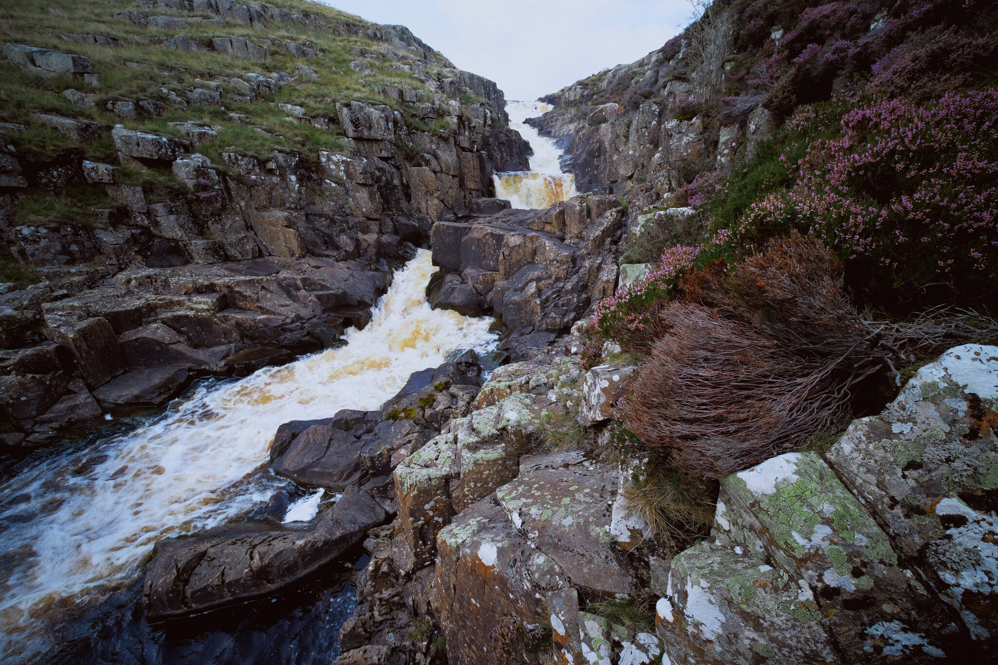
And here’s the top of Cauldron Snout. The Pennine Way is to left, but it isn’t really a “path” as such as navigating and scrambling down the side of the gorge created by the waterfall.
But doing so enables you to get right next to the falls for cracking views like this. A man perched at the top of the falls helps provide a sense of scale.
With the heather in bloom, they provided wonderful pops of colour around the waterfall.
Scrambling down the gorge was exhilarating, and definitely something that would not have been possible for my condition 5-years ago.
As the gorge sheltered us from the wind, this provided the necessary moist and still conditions for clouds of midges to form everywhere. They duly took advantage and started ravaging our bare flesh.
Near the bottom of Cauldron Snout now, and we can start to understand the scale of these falls.
The bottom of Cauldron Snout, which climaxes with this beautiful fanned curtain of a waterfall.