
Grisedale, Lake District, Winter
Happy New Year, everyone! Here’s to a peaceful and gentler 2024.
Happy New Year, everyone! Here’s to a more peaceful and gentle 2024.
Though I’ve enjoyed time off work between Christmas and New Year, it’s not exactly been pleasant. Storm Gerrit washed across the UK, rendering most days miserably wet. There were even tornado warnings, largely unheard of in the UK.
On New Year’s Eve we learned that New Year’s Day promised much nicer conditions, and so we endeavoured to rise early and head into the Lake District for a solid yomp on the first day of 2024.
Conditions were certainly nicer, though you can never predict weather in the Lake District 100%. Hiking along the valley bottom of Grisedale towards the valley’s head, we were washed with wave after wave of fine drizzle. Thankfully, it never rained that hard, and in between the downpours we still managed to nab some glorious photos.
All photos taken on my Sony α7ii using my Pentax SMC 28mm F3.5 and Pentax SMC 55mm f2.0 prime lenses. RAWs developed in Lightroom using RNI Films’ Kodachrome film profiles, finalised in Photoshop.
Grisedale, Lake District, Winter by Ian Cylkowski is licensed under CC BY-NC-SA 4.0![]()
![]()
![]()
![]()
A sign of things to come. St. Sunday Crag (841 m/2,759 ft), rising above a sodden landscape with stormy clouds above.

Much of the first half of hiking into the valley comprised of dodging waves of drizzle. When one cleared up for long enough, I snuck this shot of Eagle Crag and Dollywaggon Pike (858 m/2,815 ft) battling with the low clouds.
Arriving closer to the turning point, we contemplated the condition of the trail on the other side of the valley. The hike in, on the south of the valley, is thankfully paved but had still been rendered in parts as a beck due to all the rain. I knew that the northern path back down the valley wasn’t in as good nick. So, from here, we turned back the same way we came in.
Thankfully, this was also when conditions started to clear up and the Helvellyn range of fells began to reveal themselves.
Eagle Crag with Nethermostcove Beck roaring down the fellside. A project was started in 2021 to return the valley’s main river, Grisedale Beck, back to its original “wiggly” form. To quote the Friends of the Ullswater Way: “As with many rivers in the UK, Grisedale Beck has historically been straightened and reinforced so that fields can be drained to improve grazing. This work was undertaken over 200 years ago and since then we have learned a lot about how straightened and reinforced rivers can negatively affect wildlife and increase flood risk. It should be noted that, despite the historic changes made to the river at the project site, this is still not particularly good grazing land, being very rough pasture and quite boggy in areas.”
Heading back down the valley, we kept turning back at the beautiful view at the head of Grisedale. Primarily to check on any incoming rain washing over the fells, but also to gawp at them. I enjoyed this composition as the trail seemingly leads across the image towards Nethermostcove Beck on the right. Pure mood.
One of the few pines left in the valley points a vibrant branch towards the beautifully cracked glacial erratic.
As the cloud cover finally starts to lift, Falcon Crag and Tarn Crag emerge from behind Dollywaggon Pike.
Light finally breaks through the clouds as we retreat further down the valley.
The beck streaming down from Blind Cove provides a nice leading line towards the vertical face of St. Sunday Crag.

The fells become obscured again. Another wave of rain heads towards us.
As another squall washes over us, I look across to the northern side of Grisedale and spot these bright becks cascading down the fellside. I very quickly nab a photo.
Soon, we near the foot of the valley and the rains were finally done for the afternoon. Look at that mountain backdrop.
Heading back towards the car, the hulking mound of Place Fell catches the warm winter light across its crags.
We elected for the scenic route back to Kendal, heading north out of Patterdale, through Matterdale, and onto the A65. That way we could turn off to head down St. John’s in the Vale and join the A591 back to Kendal. I kept my camera out, with the 55m attached to it, and grabbed this epic scene of Blencathra from the passenger’s side.
Down St. John’s in the Vale, I kept snapping happily, praying that at least one of the shots rendered sharp. Here, the deep cleft of Beckthorns Gill cuts into various crags of Clough Head.
Further south on the A591, near Thirlmere, Fisherplace Gill cuts a deep fissure within the crags of the Helvellyn massif. The farmhouses below look miniscule in comparison.
The distinctive shape of Browncove Crags, a subsidiary top of Helvellyn, with another deep gill caused by Helvellyn Gill.
Did you enjoy these photos?
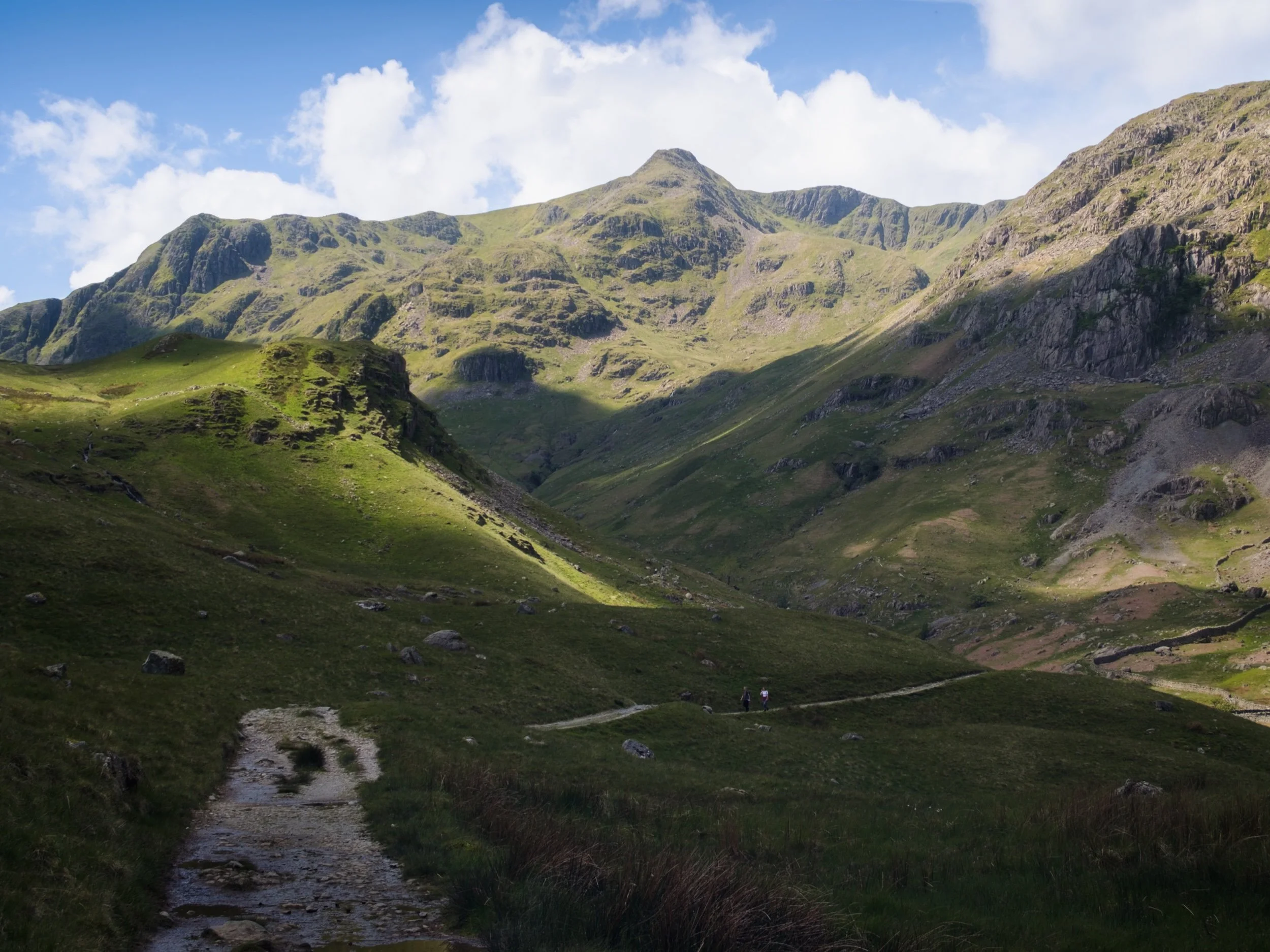
Grisedale, Lake District, Summer
It was time to show Dad the glory of Grisedale.
It was time to show Dad the glory of Grisedale.
With the Queen’s Platinum Jubilee giving us two days holiday, Dad and I were able to spend some time together. We embarked on a hike up Grisedale, an offshoot of the main Patterdale valley near Ullswater. To my mind, Grisedale features one of the greatest valley sceneries in all of the Lake District.
I’ve attempted to show Dad Grisedale before, but the good ol’ Lake District rain has impeded us.
This time, we could not have asked for better conditions.
Please enjoy these glorious scenes. And, if you do like them, consider supporting me.
All photos taken on my Fujifilm X-T2 using my new Vivitar “Series 1” 28–105 mm f/2.8–3.8 lens. Developed in Lightroom, finished in Affinity Photo. Grisedale, Lake District, Summer © 2022 by Ian Cylkowski is licensed under CC BY-NC-SA 4.0.
Parking up at Patterdale’s King George V playing fields and pavilion, you are immediately greeted with the sheer face of Place Fell.
The lane leading to Grisedale is lined with rhododendron. I think this one may be Rhododendron fauriei.
The first inkling of what lies ahead. Black Crag, a sub-peak of St. Sunday Crag, soaring above us into the clear blue sky.
The road from Patterdale to Grisedale is quite the pull, but once you arrive at the valley… wow. One of the best valley backdrops in all of Lakeland.
There were a few hikers about, which is to be expected on a Bank Holiday. However, most of them were heading up the main trail to Helvellyn via Striding Edge. Not for us, thanks.
Testing out the capabilities of my Vivitar lens. This was shot at the full 105 mm zoom. A local farmer muck spreading across the valley bottom.
At Elmhow Farm, a composition catches my eye. A small barn fell into shadow, and I notice the similarity of its silhouette with the peak of Dollywaggon Pike above. A connecting shadow cast by the passing clouds completed this composition.
Beyond Elmhow, the valley starts to narrow as we approach the head. All along the way, Dollywaggon Pike watches over us.
I love watching clouds cast shapes and shadows on a fellside.
The cloud cover starts to thicken, casting deep shadows across the mountainous landscape. Glorious light conditions.
The trail narrows and winds as we approach the head of Grisedale. High above us are Falcon Crag and Tarn Crag, which drop down to Grisedale Tarn.
The path leads around the bottom of Post, on the left, a small crag that rise out of the valley floor. Above, Dollywaggon Pike is illuminated in between the racing clouds.
The small crag of Post, on the near left, enjoys a slither of summer light scanning along its surface. In the distant left are Falcon Crag and Tarn Crag, dead centre is Dollywaggon Pike, and to the right is Eagle Crag, a sub-peak of Nethermost Pike.
Immediately above us, on the southern side of the valley, is the sheer wall of St. Sunday Crag.
Dollywaggon Pike, punching the sky, cast in light and shadow. The joy of exploring the scenery at 105mm.
Another 105mm composition, zooming in on the crags of Eagle Crag as the light plays across them.
Looking back at our progress, down the length of Grisedale back towards Place Fell.
Crossing the boggy valley floor at Grisedale Beck, Dollywaggon Pike still demanding attention as its sunlit peak acts as a beacon.
The sheer wall of St. Sunday Crag, immediately above the Crossing Plantation.
Zooming on St. Sunday Crag and the shoulder of Post, criss-crossing each other in an interesting light-filled composition.
Place Fell’s bulk rises above the rolling valley bottom of Grisedale.
Our route back involved navigating the trail on the northern side of Grisedale. Here, erect ferns line the path, ready to bloom any day.
A person-sized glacial erratic, cleft in twain.
Another look back at Grisedale’s magnificent backdrop, with fellow hikers not far behind us.
A beautiful Herdwick ewe navigates the northern fellside amongst the fern.
The last of the year’s bluebells catching the light inside Broomhill Plantation.
My Dad after nabbing a shot of the frankly stunning scenery.
A Texel (?) yew enjoys a rest in the ferns.
Her lamb, following suit.
One last look back at Grisedale, now with more cloud cover making the sun beam shafts of light on the landscape. St. Sunday Crag to the left, Dollwaggon Pike and Nethermost Pike on the right.
Back on the valley floor, a Herdwick lamb stares at us quizzically.
Another lamb enjoys a mid-afternoon snooze in the summer sun.
Do you like these photos?
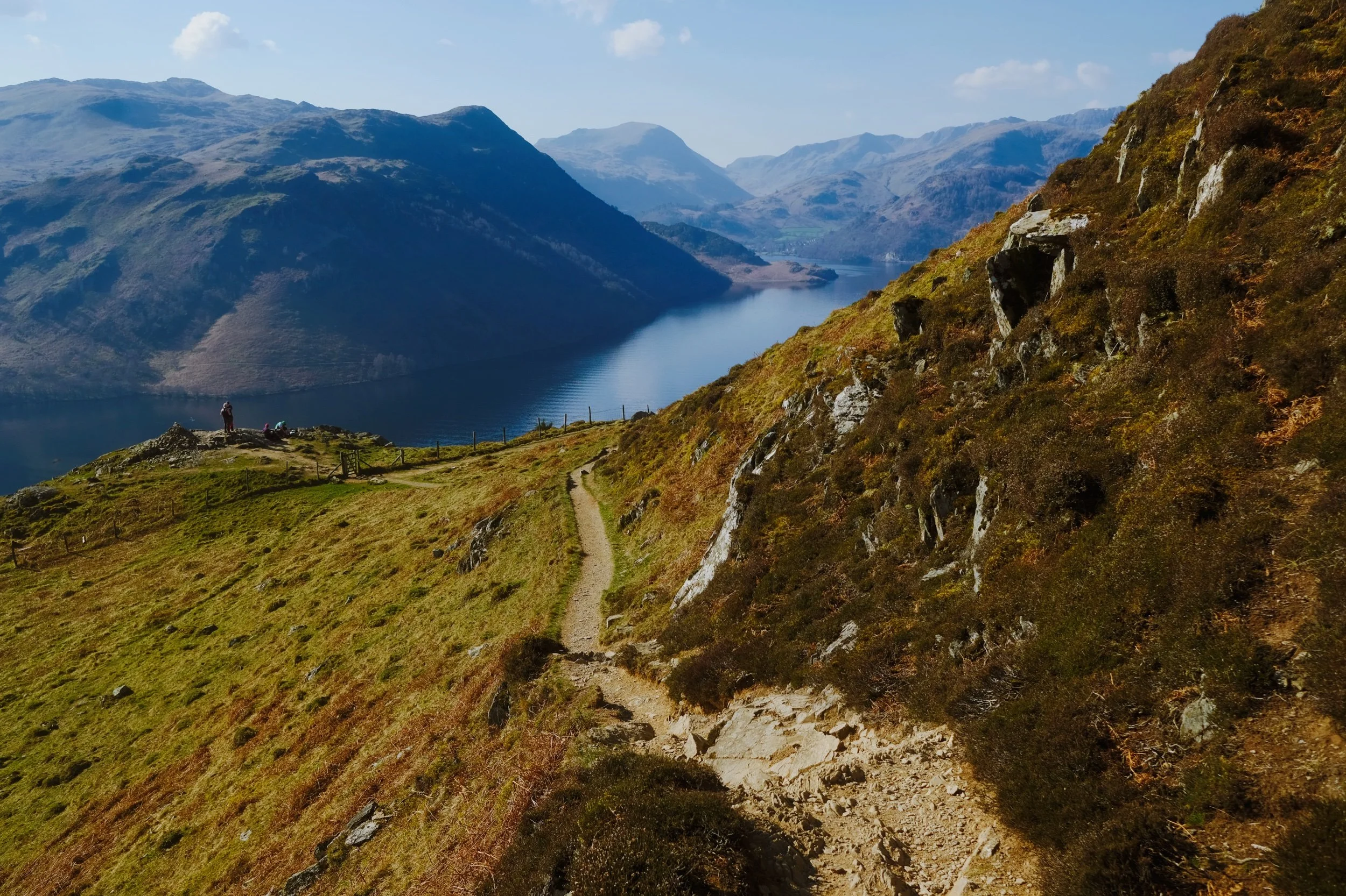
Gowbarrow, Lake District, Spring
Spring has changed very quickly in the UK.
Spring has changed very quickly in the UK.
A couple of weeks ago temperatures barely rose above 10ºC, often settling in at around 5–7ºC. Within the last week, temperatures have suddenly risen to 15ºC with clear skies and barely a breeze. Today, the weather nearly hit 20ºC.
Spring is very weird in the UK these days. That gradual transition from winter to spring doesn’t seem to happen anymore. Instead, after months of sub-5ºC conditions and plenty of rain, you’ll get a week in March or April where it feels a switch has been flicked and temperatures suddenly leap 10 degrees.
Weird.
Well, with a rare free day in current circumstances, Lisabet and I decided to get up early and head to Ullswater for a steep but rewarding hike up Gowbarrow Fell. The last time we visited this fell was back in April of 2021. The weather could not have been more different.
Thankfully, on this occasion, all of my batteries were fully charged and working. What a glorious morning’s hike we had.
All photos shot on my Fujifilm X-T2 using two of my prime lenses: a Fujinon 23mm f/2.0 and an adapted Pentax SMC 55mm f/2.0. Images made 80% in-camera using the Velvia film simulation, then finished off in Affinity Photo.
A dead tree provides a wonderful subject and contrast against the deep blue sky. A flock of Swaledales wearily judge us in the distance.
One of the many deep cascades along Aira Beck at High Cascades, before the river then plunges down the spectacular Aira Force.
These Swaledale yows moved a comfortable distance away from us for a good hard stare.
Beyond High Cascades the path turns east and climbs sharply up the fellside of Gowbarrow. Herdwick sheep were everywhere. I’ve missed those faces.
Unlike Swaledales, Herdwicks aren’t too fussed about being too near humans. I managed to snap this composition of some Herdwicks chilling in the glorious spring sunshine with the Ullswater fells in the distance.
The going was steep, but the views grew increasingly spectacular as we climbed up the fellside.
Aaaaaand summit! The summit of Gowbarrow Fell is known as Airy Crag, appropriately named, and reaches 481 m (1,578 ft) above sea level. The views here are all-encompassing, especially look southwest towards the Helvellyn fells.
I snapped on me 55mm lens for some tighter, zoomed in compositions. From the summit of Gowbarrow Fell and clear view towards Blencathra (868 m/2,848 ft) above Keswick can be appreciated.
After the summit it was a simple task of following the narrow winding footpath around Gowbarrow’s northern and eastern shoulder. In places, the drop from the footpath is rather precipitous.
Lisabet pauses to check on my progress, so I snapped this composition. Truly glory awaits us around the corner…
Hundreds of metres below us the Ullswater Steamers begin the first of many travels across the lake.
And there it is. In my view, one of the grandest views in all of the Lake District. Ullswater and the Helvellyn fells.
Who can resist pausing for a rest and some photos, with a view like that?
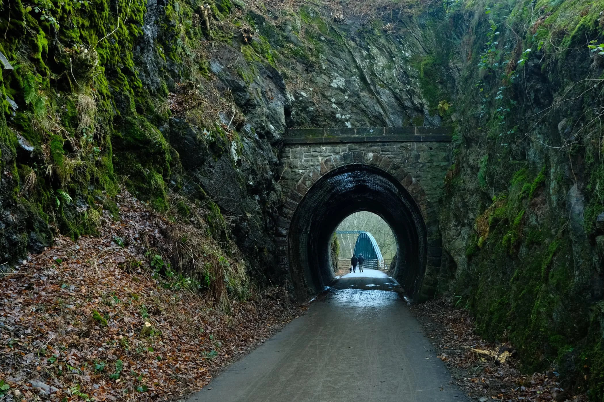
Keswick–Threlkeld Railway, Lake District, Winter
And now for something completely different.
And now for something completely different.
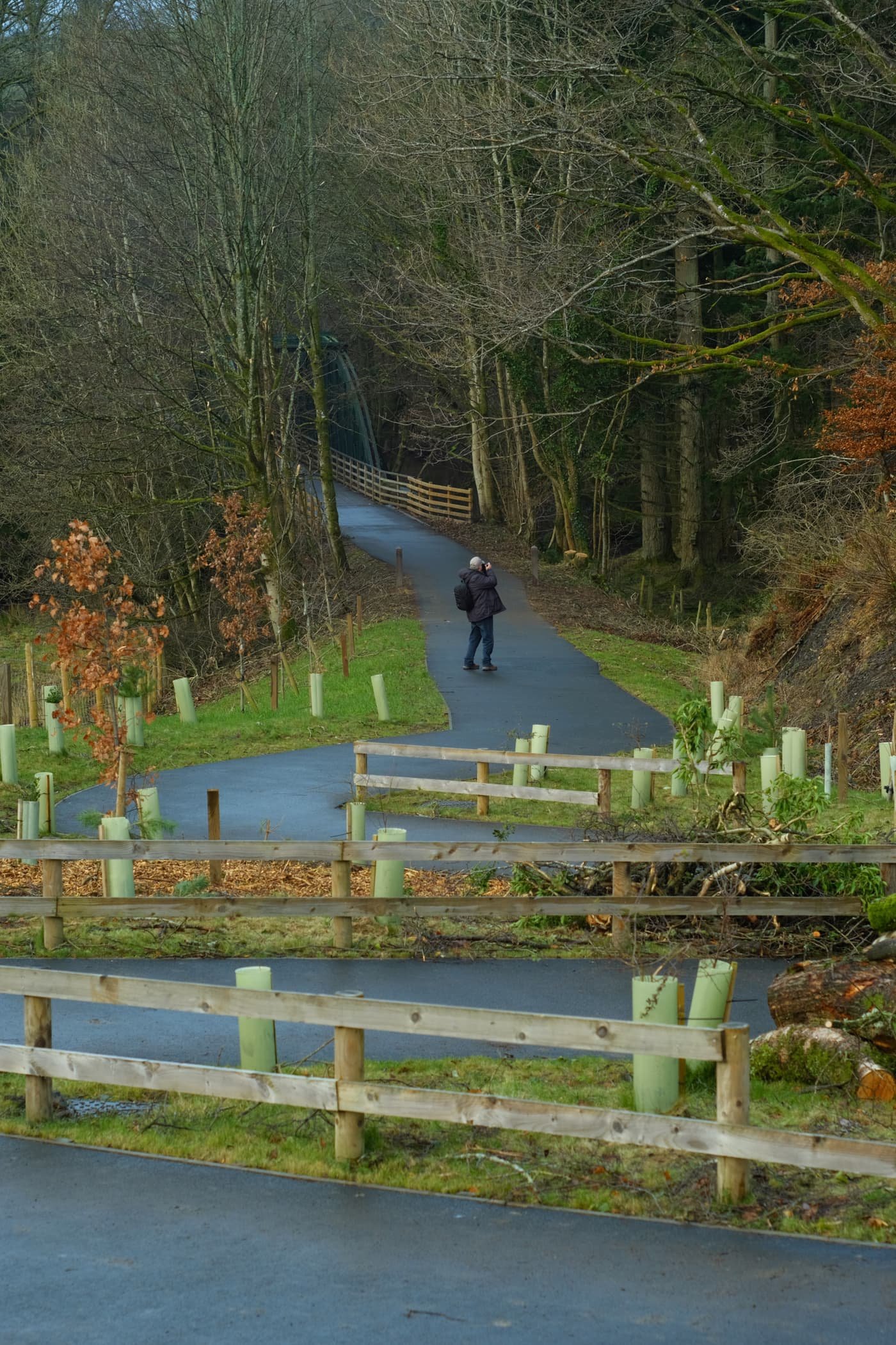
After yesterday’s thrilling circular hike around the gorgeous and epic Malhamdale, today we embarked on something a little more tourist-friendly and flat: the Keswick–Threlkeld Railway walk.
The 5km walk follows the route of the old Cockermouth, Keswick and Penrith Railway from Keswick to Threlkeld. It was constructed in 1864 with the goal of connecting the town of Cockermouth with the London and North Western Railway (LNWR) West Coast Main Line at Penrith. It closed to passengers and business in the 1960s and 1970s.
Much of the trail was badly damaged or totally destroyed by Storm Desmond in December 2015. Major restoration work was undertaken and the trail was upgraded and reopened in December 2020.
Lisabet and I met met up with me Dad near the start of the trail at Keswick, and followed the route all the way to Threlkeld and back, a good 6.2 miles and 17,000 steps later.
We were blessed with lifting hill fog, resulting in some incredible scenes of clouds whipping around the shoulders of nearby fells Lonscale Fell, Blencathra, and even some of the Helvellyn fells.
This route will definitely be one to revisit in Spring and Summer.
All photos taken on my Fujifilm X-T2 using my three prime lenses: a Fujinon 23mm f/2.0, a Laowa 9mm f/2.8, and an adapted Pentax SMC 55mm f/2.0. Images made in-camera, with no additional editing, using Øyvind Nordhagen‘s Overcast Fujifilm recipe.
The Keswick Hotel, which also seems to come with its own garage. At least, it used to.
The aforementioned Keswick Hotel Garage.

The Keswick–Threlkeld Railway trail starts near Keswick Leisure Centre, alongside the old station. I nabbed a sneaky shot of me Dad.
It wasn’t long before the trail started offering some lovely views along the River Greta towards the fells above Keswick. The main fell pictured here is a favourite of ours, Latrigg.
Where possible the Lake District National Park have tried to save and restore as many of the old Victorian bridges and tunnels as possible.
Near the “big” tunnel there’s a little commemorative sculpture, erected to celebrate the National Cycle Route and the Coast to Coast trail.
Into the “big” tunnel we go…
Again, beautifully preserved Victorian engineering, now with the added convenience of modern lighting and smooth, durable tarmac.
On the other side of the tunnel, panoramic views of the River Greta and Latrigg open up.
Despite being in winter, it was lovely to still see some colour about.

One of many of the newer bridges that criss-cross the winding River Greta.
Evidence of Storm Desmond, which scoured the river banks clean. You can still the level that river came up to during the storm. Land slips ahoy.
A nice little holiday village, Low Briery, alongside the River Greta.
The trees now denuded of their leafy vegetation, line the river and serve as a leading line towards Latrigg.
Onwards to the next bridge. There were plenty of other people around enjoying this trail. It was a good job we got started nice and early.
The next bridge to cross the River Greta. The Greta Gorge flattens out at this point, providing “in-bye” land for nearby hill farmers to use for their grazing flocks of sheep.

I wanted to play with lines and angles provided by this bridge, so I snapped on my ultra-wide 9mm lens for some fun compositions.
Not a bad spot for a bit of lunch.
The gorge created of the River Greta flattens out here, opening more perspectives of the Latrigg fells above.
To the north, the clouds were starting to lift from mighty Blencathra.
A solitary tree has survived erosion and storms against all the odds, and stands proudly in the middle of the river.
The excitement levels rise as we catch our first glimpse of Blencathra’s jagged peaks.
Additionally, to the east, the morning hill fog was wrestling with the crags of Clough Head, part of the Helvellyn range.
Beyond Latrigg, the crags of Lonscale, too, were freeing themselves of the morning’s mist.

The shoulder of Lonscale Fell high above the Greta Gorge.
Another relic of Victorian engineering, a small tunnel blasted through the crag leading to Rawsome’s Bridge.
Near Threlkeld, lots of trees were covered in beautiful and vibrant moss as the gorge walls closed in.
The end of the trail. Beyond the A66, Clough Head provides a dramatic backdrop as it tussles with the clearing fog and mist.
Blencathra’s craggy and jagged peaks, now nearly clear of morning mist.
Dad leads the way back to Keswick, happily snapping away.
There’s something wonderfully eldritch about wintery trees covered in moss.
Quite happy with this candid snap of me Dad.
Lonscale Fell again, now apparently losing its battle against the sky.
Blease Fell below Blencathra, and a band of mist clinging to its shoulder.
At around lunchtime, the sun finally broke through the thick cloud cover and illuminated these trees in golden light.
Overall, I can heartily recommend this trail. I look forward to returning in the spring and summer, when there’s more wildlife and flora about.
Walla Crag, Lake District, Autumn
Autumn has arrived.
Autumn has arrived.
The “life” from all the verdant vegetation is starting to wane, the ferns are turning rust-hued, and the leaves are beginning to drop. Autumn’s here, and I cannot wait for those autumnal colours.
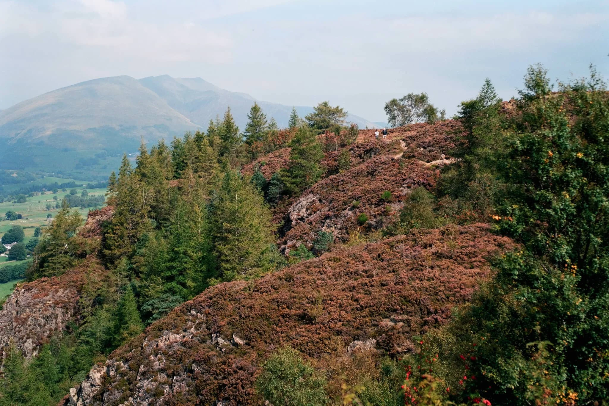
Whilst we wait, we decided today on a venture up a relatively small fell that we’ve never tried before: Walla Crag (379 m/1,243 ft).
At “only” 379 m tall it’s definitely one of the smaller fells, especially when compared to some of the giants in the area such as Skiddaw (931 m/3,054 ft) and Blencathra (868 m/2,848 ft). Nevertheless, what it lacks in height it makes up for in the jaw-dropping views it offers from its summit.
All photos shot on my Fujifilm X-T2 using my three prime lenses: a Samyang 35mm f/1.2, a Laowa 9mm f/2.8, and an adapted Pentax SMC 55mm f/2.0. Developed using RNI Films’ Kodak Ektar 100 profile.
Not far along the trail and already the views really open up. A couple enjoy a picnic in the sun with the backdrop of the Helvellyn fells behind them.
A row of Roman trees, Sorbus aucuparia, filled with their fruit frame the trail looking back to Blencathra in the distance.
The trail starts rising, offering up views looking back towards the likes of Lonscale Fell (715 m/2,346 ft).
By now the full profile of Skiddaw, its fells, and the smooth profile of Latrigg are fully exposed. It’s turning out to be a crackin’ day.
Plenty of other fell walkers were making their way up and down the trail. To the left in the distance is the magnificent slopes and peaks of Blencathra.
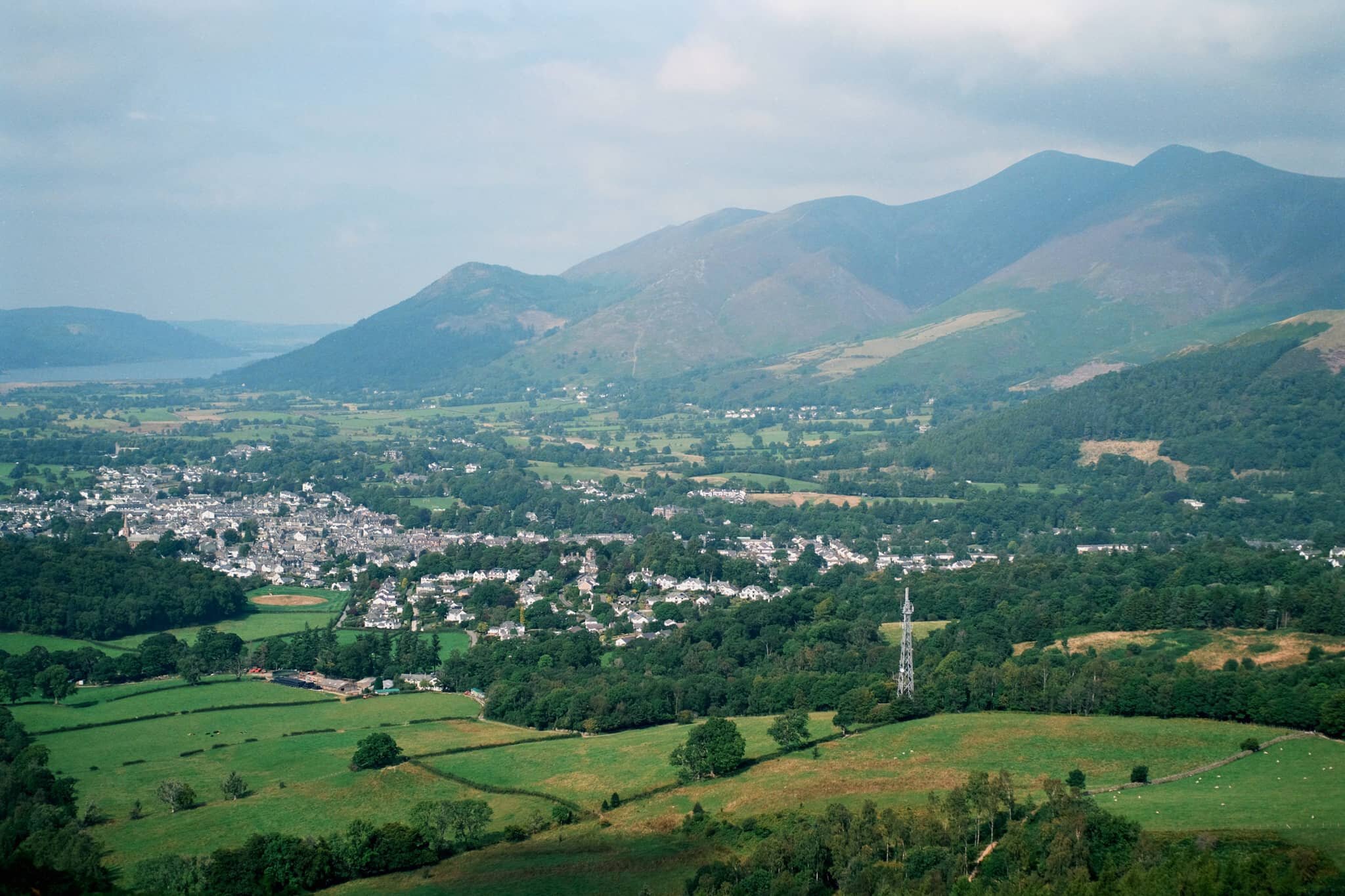
Skiddaw’s multi-peak shape looms of the bonny town of Keswick.
On our way up, the views towards the Derwentwater Fells, too, soon open up and our sense of anticipation grows.
Rowan trees and their vivid berries frame the Derwentwater fells on a somewhat hazy day.
Another lovely aspect to Walla Crag’s environment is the sheer abundance of pink heather everywhere.
The water level at Derwentwater is ridiculously low. New gravelly islands are reappearing and existing ones are gaining new shores.
It soon becomes apparent how much of a drop there is from Walla Crag’s northwestern face.
As more sun comes out, I spot another framing opportunity full of colour.
Looking back at the cliff-edge trail we followed. The amount of heather around Walla Crag is ludicrous.
Like, so much heather…
Aaaand… summit! Plenty of other folk enjoying the views from Walla Crag summit too. We stop for a quick bite and some water, taking the panorama in.
My ultra-wide 9mm lens was able to take in the vast panorama available from the summit of Walla Crag. One of the best views in the whole of the Lake District.
With my 55mm attached, it was time to pick out some smaller scenes amongst the vast panorama. The hazy conditions allowed for a wonderful layering affect with Derwentwater Fells.
Mighty Skiddaw looming above Keswick.
After taking everything in, it was time to follow the trail back down from the summit towards the main path off Walla Crag, with heather still in abundance.
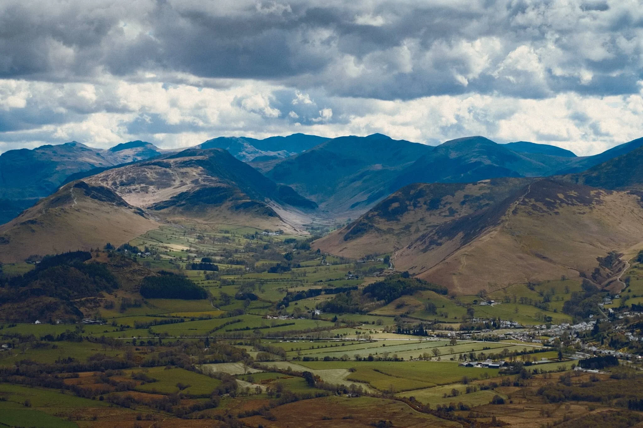
Looking across the moorland and ferns, deep into the Jaws of Borrowdale.
Fellow hikers branch off from the path to take in the views towards the Helvellyn range, and Clough Head (726 m/2,382 ft) in particular.
Seemingly endless layers of fells in Borrowdale.
On the way back down off the fell, I spot this tree and arrange it underneath the peaks of Blencathra.
Magnificent Blencathra, demanding our constant attention as we climb off the shoulders of Walla Crag.
This is Armillaria mellea, or honey fungus. Apparently highly revered for its edible qualities, though a lot of UK species react with alcohol badly in people’s bodies causing nausea and vomiting. It’s generally best to parboil these mushrooms, and not consume alcohol for a day before and after eating them.
Follow other hikers along the trail back down to the car. The haze appears to lift somewhat around the Helvellyn fells.
The Helvellyn range above, with High Rigg and Low Rigg below.
Another fantastic day.
Dodd Woods, Lake District, Spring
After an unusually dry and cold April 2021, the rain has returned.
After an unusually dry and cold April 2021, the rain has returned.
This Bank Holiday Lisabet and I planned on a long hike through the Mallerstang valley in the Yorkshire Dales, a favourite of ours. However, reading all the weather radars and forecasts indicated a lot of rain was on its way through South Lakes and the Yorkshire Dales. By contrast, the northern Lake District looked pretty good. So we changed plans and embarked on a hike up Dodd (502 m/1,647 ft), a small fell that came highly recommended by a friend of mine.
Dodd is part of the Skiddaw range, a massive bulk of fells to the north of Keswick, which tops out at Skiddaw itself at 931 m/3,054 ft asl. Most of the fell is covered in trees as it’s owned by the Forestry Commission but the summit is bald, allowing for extensive views towards either Derwentwater and the Newland Fells or Bassenthwaite Lake and out towards the Solway Firth.
Despite changeable conditions, the car park was extremely busy and we were lucky to get parked where we did. Thankfully there is plenty of signage around Dodd Woods and we simply followed Dodd Summit Trail, snapping happily along the way. There is a lot to be said for roaming around dense woods and the quality of light you get, not to mention the incredulous views you get from around the summit of Dodd.
All photos taken on my Fujifilm X-T2 using two of my prime lenses: a Samyang 35mm f/1.2 and an adapted Pentax SMC 55mm f/2.0. Developed using RNI’s Kodachrome film profiles.
The clarity of light was superb.
Lots of families wandering around Dodd Woods, enjoying the scenery and crisp sun.
I had to line up a composition involving this unusual tree, which had formed a sort of natural arch over the footpath.
Skill Beck, like a lot of rivers in the Lake District at the moment, was very dry and barely a trickle, as it tumbled through the woods.
I love the soft transitions of light and shadow you get in the woods.
We continue upwards, following the Dodd Summit Trail.
About three quarters of the way through the hike, the tree cover starts to open up, letting in more light. I quickly snapped this photo of my lovely Lisabet as she entered a zone of open light.
Underneath Dodd summit I spotted this wonderful crag marked with flecks of vivid orange and red. I wonder if there’s iron ore in the rock around here?
Our first glimpse of the views that Dodd offers. And we weren’t even at the top yet! Absolutely immaculate. Showing Derwentwater and its fells, with the bonny town of Keswick to left.
The Newland Valley and its fells, with the Dodd Summit exit trail below.
Again with that soft woodland light…
I have to remind myself, when I’ve got my head down hiking up a fell, to always look back. Had I not done so, I would’ve missed this! The view all the way back towards the Helvellyn range, and you can even clearly see the Helvellyn (950 m/3,118 ft) summit itself, catching some highlighting!
Bassenthwaite Lake framed by two trees; famously cited as the only “lake” in the Lake District (that is, the only lake with the word “lake” in its name). The atmosphere was so clear you could also make out the Solway Firth and the Galloway mountains in Scotland.
And we reach the summit. Some of the best views of the Northern Lake District I’ve ever seen.
The Lorton Fells and Grisedale Pike. Little hovering spots of light scan across the land.
My lovely Lisabet at the summit, getting those views.
I popped on my 55mm lens to zoom in further and pick out specific scenes from the vast panorama available from the summit of Dodd. The Newland valley and fells, in particular, were looking absolutely splendid.
Lord’s Seat (552 m/1,811 ft) from across Bassenthwaite Lake.
Honestly, I could’ve taken thousands of shots from the summit of Dodd…
Grisedale Pike (791 m/2,595 ft) catching some lovely light above the Whinlatter Forest.
Following the narrow trail back down the slopes of Dodd
As we climb down the wooded fell slopes, the landscape changed from craggy to mossy and grassy.
Lovely light catching the trees and footpath.
Heading our way back down to the car, soft afternoon light blooming through the woods. I liked the tree on the right, looks like a tuning fork.