
Lingmoor Fell, Lake District, Winter
I’ve been wanting to get into the snowy mountains for a while.
I’ve been wanting to get into the snowy mountains for a while.
As I’d accrued a fairly significant amount of flexi-time at work, I used it to take a mid-week day off and headed into Lake District.
Lingmoor Fell is a small hill I’ve had my eye on for quite some time. It’s only a modest fell, standing at 469 m (1,540 ft) a.s.l., but what it lacks in height it more than makes up with the sensational views it offers. Lingmoor Fell’s isolated position in the Central Lake District—separating Great Langdale from Little Langdale—means some of the finest panoramas in all the Lake District can be found on this small fell.
Though I ultimately didn’t feel confident or skilled enough to properly summit Lingmoor in the current sub-zero temperatures, I nevertheless managed ascending the fell’s shoulders and obtained some absolutely crackin’ photos.
All photos taken on my Fujifilm X-T2 using my Vivitar “Series 1” 28–105mm f2.8–3.8 zoom and Laowa 9mm f2.8 prime lenses. Shot using the camera’s Classic Chrome film simulation, edited in Capture One for iPad, and finished in Affinity Photo 2 for iPad.
Lingmoor Fell, Lake District, Winter by Ian Cylkowski is licensed under CC BY-NC-SA 4.0![]()
![]()
![]()
![]()
The start of the walk ascends the fellside from Elterwater village, through winding country roads that have become a winter wonderland, totally frozen.
After navigating the country roads and Sawrey’s Wood, you soon emerge onto the open fellside with wonderful views across Great Langdale towards the Grasmere fells.
The tiny village of Chapel Stile in the Great Langdale valley, with the rusty, craggy fells looming high above in the morning winter light.
Lots of quarrying has happened around the slopes of Lingmoor Fell, and continues to this day (though on a much smaller scale). I sneaked into this disused quarry largely for the icicles.
The old miner’s track provided a clear way up the fell. The day was crisp and bitingly cold, with the moon clear above. My destination was the peak illuminated by the sun.
It didn’t take long before I came across the Lake District’s famous sheep, Herdwicks. The path continued up to the left.
Herdwicks are such posers. They know they’re pretty.
Up on the shoulder of Lingmoor Fell the views instantly open up in all directions. Here the rusty bracken and crags of Lingmoor Fell provide a nice contrast to the distant wintery views of Ambleside and the Kentmere fells.
Over the wall, towards Grasmere, Fairfield can now clearly be seen with a dusting of frost on its flat summit.
Herdwicks graze upon the scant vegetation of a crag. The ridge of Lingmoor Fell is totally lined with this drystone wall, making it easy to navigate along the fell.
I turned away from summiting Lingmoor Fell as the path quickly become a long sheet of ice. Instead, I skirted around its shoulder towards some disused quarries. Here, Wetherlam and Swirl How revealed their wintery magnificence to me.
I took a water break near this crag and started crawling around it with my ultra-wide angle lens, looking for compositions involving those beautiful wintery mountains.
This one’s probably the best of the bunch.
Heading back down the old miner’s track, I catch a glimpse of one the axe-like peaks of the Langdale Pikes, and line up a composition.
Not a bad place for a cottage, eh?
Back on the winding country roads towards Elterwater village.
What a crackin’ day.
Did you like these photos?
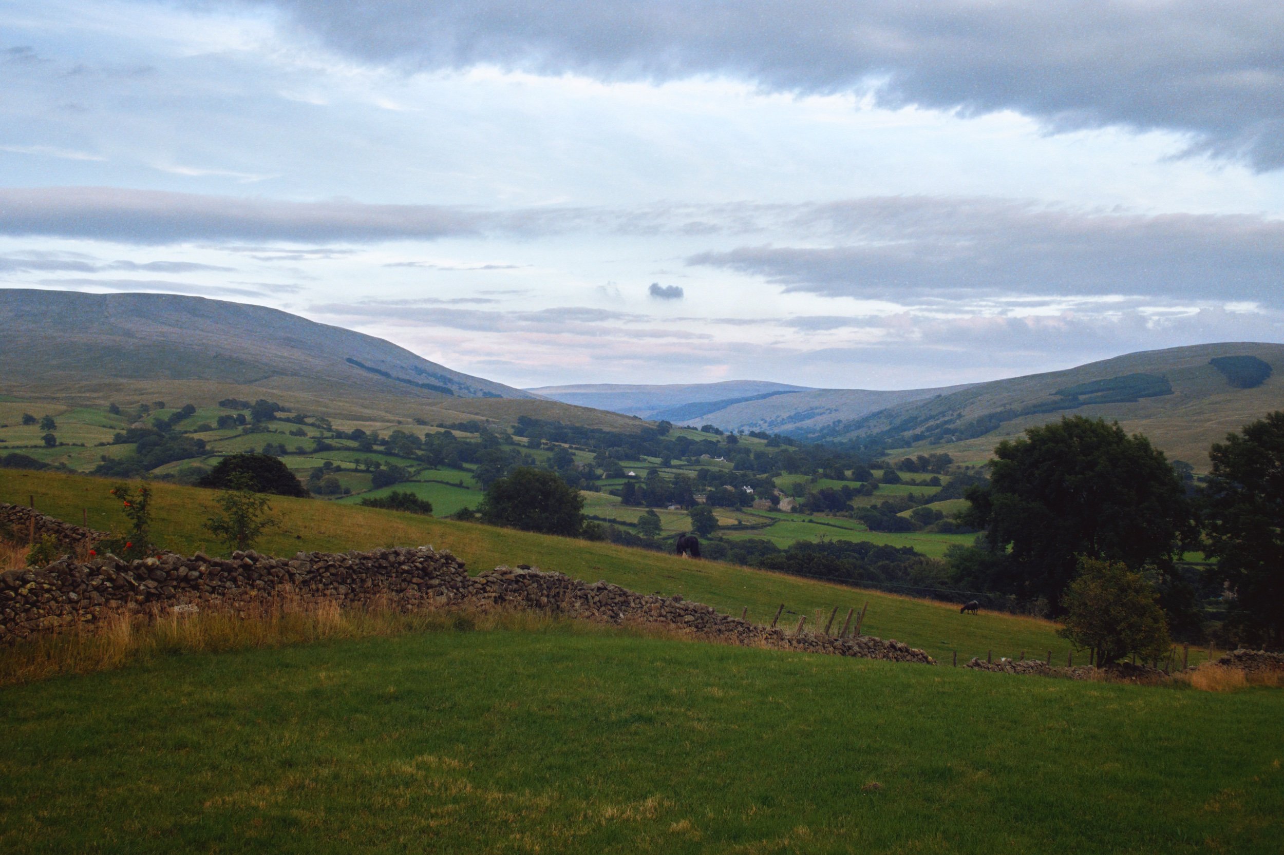
Sedbergh Meadows, Cumbria, Summer
British weather has returned to its unpredictable norm since the heatwave.
British weather has returned to its unpredictable norm since the heatwave.
This has made getting out for good long hikes—either during the weekends or in the evenings—difficult. We’ve had periods of torrential downpours, almost monsoon-like.
Britain gets more tropical by the year.
Finally, yesterday evening, an opportunity arose to vacate Kendal for a nice hike around Sedbergh and its gorgeous meadow fields underneath the Howgills.
The good light didn’t last long… but it was long enough.
All photos taken on my Fujifilm X-T2 using a Vivitar “Series 1” 28–105mm f2.8–f3.8 zoom lens. RAWs converted in Capture One for iPad, developed in RNI Films, finalised in Affinity Photo for iPad.
Sedbergh Meadows, Cumbria, Summer by Ian Cylkowski is licensed under CC BY-NC-SA 4.0![]()
![]()
![]()
![]()
The walk begins up Castlehaw Lane, which takes you up and around the shoulder of Castlehaw Tower. Sedbergh is full of ancient buildings, some better preserved than others.
Soft light on this tree trunk provides an irresistible scene for me to capture.
Further up Castlehaw Lane lots of wild vegetation lined the track, including something more unfamiliar and almost “alien” to us. Turns out this is Elephant Garlic, or Allium ampeloprasum var. ampeloprasum. Closer relative of leek than garlic, apparently. Never seen one before.
Beyond Castlehaw Lane and Howgill Barns, the track becomes little more than a vague depression across the fields. The views also open up tremendously, here showing a clear view towards Garsdale in the Yorkshire Dales.
What turned out to be the last of the evening’s light finally appeared, illuminating the fields, trees and fellside. It was very localised though, and the Dentdale fells were still dark with rain clouds.
A variety of cross-breed upland lambs glow in the evening light. They stared at us curiously, incessantly baaing and warning each other.
The light quickly started to fade but the views were still spectacular.
At Ghyll Farm we cut the usual long hike short as the light was fading. A vague path bisected through the fields towards Underbank, which we took. Along the way, beautiful strong horses were peacefully grazing the meadows.
A brave Texel yow approaches us for a closer look.
The famous Herdwick. Just look at that Teddy Bear-like face.
From Underbank we located an ancient lonnin (country lane), which heads all the way back to town. You can almost picture a shepherd guiding their flock along the lane.
An almost timeless scene.
Did you like these photos?
Gowbarrow, Lake District, Spring
Spring has changed very quickly in the UK.
Spring has changed very quickly in the UK.
A couple of weeks ago temperatures barely rose above 10ºC, often settling in at around 5–7ºC. Within the last week, temperatures have suddenly risen to 15ºC with clear skies and barely a breeze. Today, the weather nearly hit 20ºC.
Spring is very weird in the UK these days. That gradual transition from winter to spring doesn’t seem to happen anymore. Instead, after months of sub-5ºC conditions and plenty of rain, you’ll get a week in March or April where it feels a switch has been flicked and temperatures suddenly leap 10 degrees.
Weird.
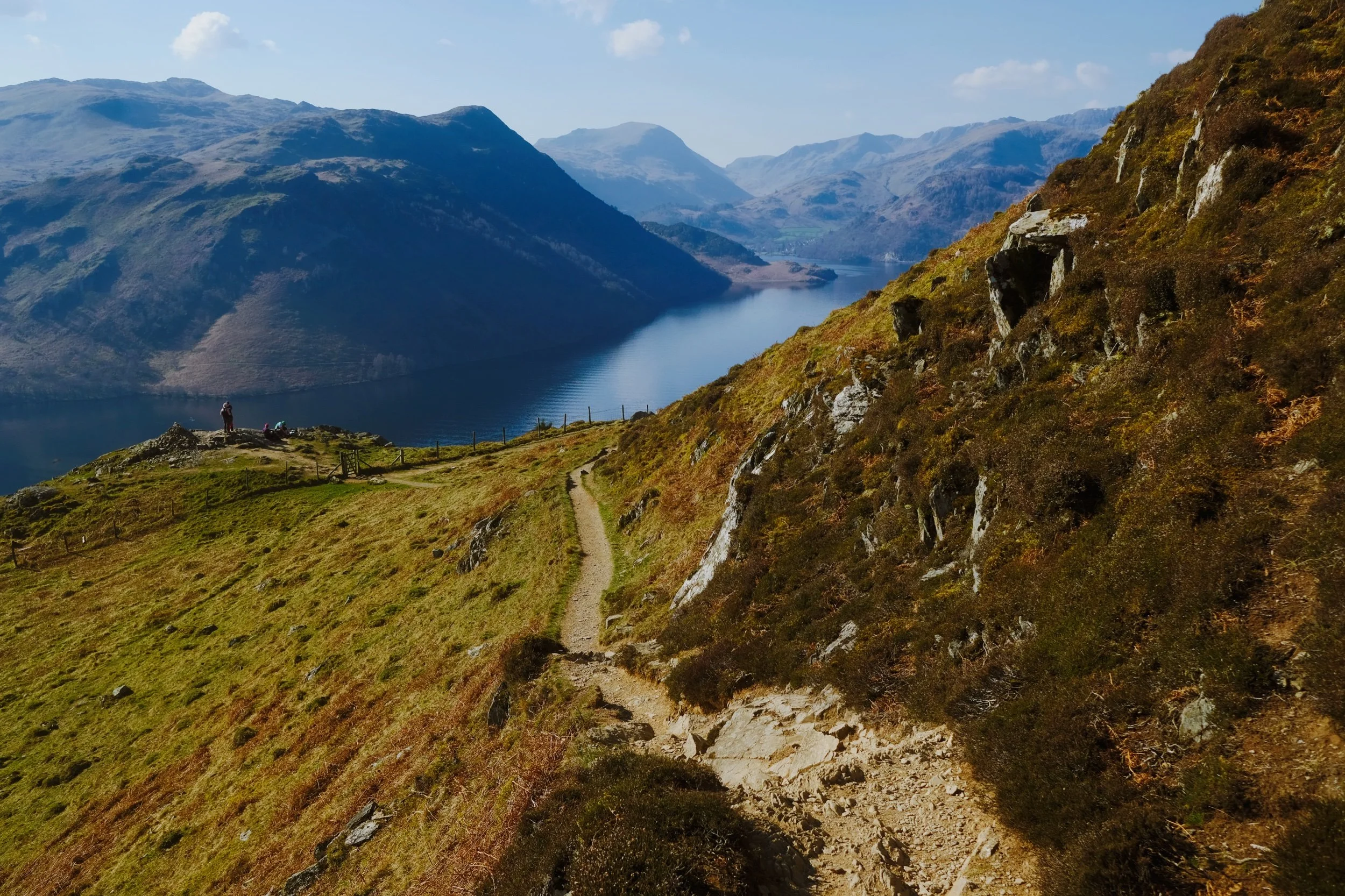
Well, with a rare free day in current circumstances, Lisabet and I decided to get up early and head to Ullswater for a steep but rewarding hike up Gowbarrow Fell. The last time we visited this fell was back in April of 2021. The weather could not have been more different.
Thankfully, on this occasion, all of my batteries were fully charged and working. What a glorious morning’s hike we had.
All photos shot on my Fujifilm X-T2 using two of my prime lenses: a Fujinon 23mm f/2.0 and an adapted Pentax SMC 55mm f/2.0. Images made 80% in-camera using the Velvia film simulation, then finished off in Affinity Photo.
A dead tree provides a wonderful subject and contrast against the deep blue sky. A flock of Swaledales wearily judge us in the distance.
One of the many deep cascades along Aira Beck at High Cascades, before the river then plunges down the spectacular Aira Force.
These Swaledale yows moved a comfortable distance away from us for a good hard stare.
Beyond High Cascades the path turns east and climbs sharply up the fellside of Gowbarrow. Herdwick sheep were everywhere. I’ve missed those faces.
Unlike Swaledales, Herdwicks aren’t too fussed about being too near humans. I managed to snap this composition of some Herdwicks chilling in the glorious spring sunshine with the Ullswater fells in the distance.
The going was steep, but the views grew increasingly spectacular as we climbed up the fellside.
Aaaaaand summit! The summit of Gowbarrow Fell is known as Airy Crag, appropriately named, and reaches 481 m (1,578 ft) above sea level. The views here are all-encompassing, especially look southwest towards the Helvellyn fells.
I snapped on me 55mm lens for some tighter, zoomed in compositions. From the summit of Gowbarrow Fell and clear view towards Blencathra (868 m/2,848 ft) above Keswick can be appreciated.
After the summit it was a simple task of following the narrow winding footpath around Gowbarrow’s northern and eastern shoulder. In places, the drop from the footpath is rather precipitous.
Lisabet pauses to check on my progress, so I snapped this composition. Truly glory awaits us around the corner…
Hundreds of metres below us the Ullswater Steamers begin the first of many travels across the lake.
And there it is. In my view, one of the grandest views in all of the Lake District. Ullswater and the Helvellyn fells.
Who can resist pausing for a rest and some photos, with a view like that?
Newlands Valley, Lake District, Summer
On the Sunday following the Saturday, we threw caution to the wind and visited the Lake District for a solid hike.
On the Sunday following the Saturday, we threw caution to the wind and visited the Lake District for a solid hike.
Signs were looking good that, for a Sunday morning, the Lake District wasn’t looking too busy (use Safer Lakes to check the busyness of Lake District car parks). We drove to Keswick and plotted a hiking route from the town onto the Cumbria Way towards the Lingholm Estate, where we’d pause for refreshment. Then we’d continue on the Cumbria Way towards the foot of Catbells, and break off into the Newlands Valley, terminating at Little Town and circling back all the way to Keswick.
All in all, about 16 km and 25,000 steps. Pretty good.
It was a stupendously beautiful day in the Lake District, and the Newlands Valley in particular was looking absolutely incredible.
Please enjoy these photos.
All photos shot on my Fujifilm X-T2 using my three prime lenses: a Samyang 35mm f/1.2, a Laowa 9mm f/2.8, and an adapted Pentax SMC 55mm f/2.0 lens. Images were made 80% in-camera using a customised Velvia film simulation, with minor edits afterwards in Lightroom and Affinity Photo.
Crossing the Greta Bridge here signifies the start of our walk onto the Cumbria Way. Given the weather we’d had, the river was looking very low.
The Cumbria Way bisects an open field, with clear views towards the Newlands fells one way and the Skiddaw range the other.
Pure Lake District. Mountains above, Herdwick sheep below.
Hot Herdwick ewes and their lamb find shade wherever they can. They’re about ready for clipping (shearing) I reckon.
Just south of the village of Portinscale, you enter a heavily wooded area. This is all part of the Lingholm Estate, the centre of which is a Victorian mansion built in the 1870s by Alfred Waterhouse.
The grounds of Lingholm Estate, and especially the Walled Gardens and Kitchen, are beautifully maintained.
Beatrix Potter made sketches of the octagonal kitchen garden and referred to it as her original inspiration for Mr McGregor’s garden in The Tale of Peter Rabbit.
Rhododendrons and foxglove. Pretty colour contrasts.
Everything was looking so lush in the gardens.
A brief window of light penetrates the woodland canopy, illuminating this uprooted tree.
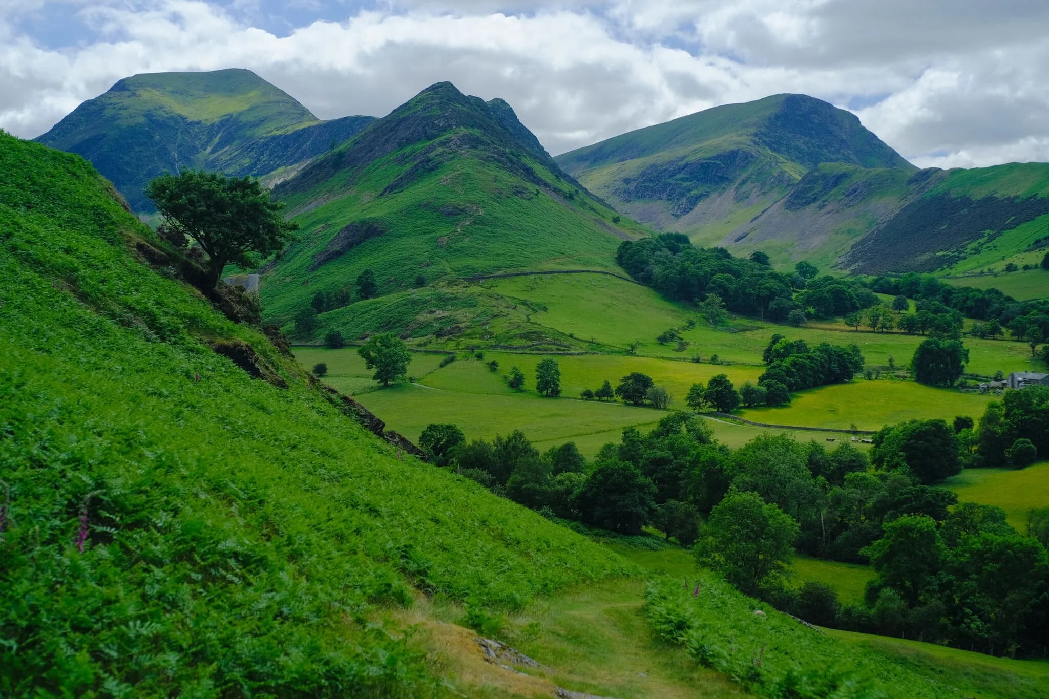
After popping out of Overside Wood you enter what is simply known as The Park, and are greeted with the northern ridge of Catbells (451 m/1,480 ft), one of the Lake District’s most famous mountains.
Our journey that day did not involve Catbells, especially with the veritable train of people following the path up to the fell’s summit. Instead we took the minor road around the mountain’s western shoulder, heading towards the Newlands Valley. Already, the views look wonderful.
One of Keswick’s more familiar sights is the knobbly profile of Causey Pike (637 m/2,090 ft).
Rowling End (433 m/1,421 ft) slightly obscuring Causey Pike with Birkrigg Farm below.
Looking back the way we came, with the massive Skiddaw range looming above Keswick. My lovely Lisabet looking, well, lovely!
Following the minor road around Catbells’ western shoulder, the views open up more and more, giving us extensive panoramas of the Newlands fells.
An ultra-wide perspective of our way forward as the Newlands valley opens up.
The fell in the centre that looks like it’s had a massive bite taken out of it is Robinson (737 m/2,418 ft). The name might seem unusual, given most fell and place names in Cumbria have Old Norse origins. Apparently the land that included the fell was purchased by a Richard Robinson centuries ago. The fell, at the time unnamed, became known as Robinson’s Fell, and eventually shortened to Robinson.
I suspect this minor road was once a miner’s road (see what I did there?). According to the OS Map, ahead of us at Yewthwaite was some disused old mining works beneath Maiden Moor (576 m/1,890 ft).
We followed the trail through the old mines and onward towards Little Town. Ahead of us, Ard Crags’ (581 m/1,906 ft) pointy profile is revealed. But what I’m looking for is just around the corner of High Crags…
And there it is. In my mind, one of the best views in all of Lakeland. Dale Head (753 m/2,470 ft) on the left, Hindscarth (727 m/2,385 ft) in the middle, and Robinson on the right.
Looking back the other way, we are treated to another gorgeous Lakeland summer scene. Herdwick sheep in the valley bottom, the Skiddaw range above.
We stopped for refreshment and delicious ice cream at Catbells Café in Little Town. Ard Crags, like a toddler amongst the grown-ups, still very much demanded our attention. Not a bad spot for refreshments, eh?
After pausing at Little Town we circled back and followed the trail all the way back towards the Cumbria Way and Keswick. This part of the trail is closer to the valley bottom and more open, giving us different views entirely.
A pleasing composition of ancient trees, farm fence and gate, and the Skiddaw range.
Lots of the standalone trees around this part of the Newlands Valley I suspect are rather old, and remnants from when this valley was cleared of woodland by Viking settlers.
It also means you find strange and unusual trees, such as this beauty. Ever seen a tree trunk like it?!
From one field into another, following an ancient lane back towards Skiddaw.
One final look back at the Newlands fells, with groups of Texel sheep and lambs dotted about.
Back on the minor road underneath Catbells. Lisabet grabs a rare selfie, with Blencathra looking mighty in the distance.
Stormwater Bridge, a suspended footbridge, indicates our approach is near Keswick. The Skiddaw range looms ever closer.
Herdwick lambs seeking shade from the warm day. They are born jet black, save for tufts of white around their ears. As they age, their face and legs turn white and their fleece becomes a dark, chocolatey brown. It’s not until they’re 2-3 years of age that they get their first clip (shear), which reveals the characteristic grey Herdwick fleece underneath.
Zen Cow is contemplating existence…
Keswick town was busy. Time to navigate through the crowds in order to get back to the car.
What a wonderful day it was.

Great Langdale, Lake District, Autumn
Do you know what one of my favourite areas in the Lake District is?
Let’s take a break from my recent run of Isle of Skye images.
Do you know what one of my favourite areas in the Lake District is? It’s Great Langdale.
We recently invited my Dad over to come stay with us, as he’s in our support bubble and lives on his own. On the Saturday I took Dad to explore Great Langdale, which he had never seen before. It’s good to know there’s still places in the Lake District I can let my Dad experience for the very first time.
It is an awe-inspiring place. Great Langdale is a fairly flat-bottomed valley that features a northern wall of some of the finest and most recognisable crags and peaks in the Lake District: the Langdale Pikes.
Judging from the amount of photos, I think Dad found it inspiring too.
All photos shot on my Fujifilm X-T2 using both my Samyang 35mm f/1.2 and Laowa 9mm f/2.8 lenses (with some additional help from Dad’s 55-200mm f/3.5–4.8). I used a customised Provia Standard film profile.
It was prime tupping season in the valley bottom of Great Langdale. Plenty of Herdwick yows (ewes) around with one or two tups (rams) doing their… duty.
We experienced some wonderful play of light streaming across the Langdale Pikes. I borrowed Dad’s 55-200mm lens to really zoom on those famous crags. Stickle Ghyll, the series of cascades and falls to the right of the photo, was in full spate.
There were plenty of puddles on the trail, which enabled to shot a composition of the Langdale Pikes I’ve been after for a long time.
More beautiful late afternoon light, picking out the contours and crags of the Langdale Pikes.
To the east of the Langdale Pikes is a wall of fells peaking at Broad Crag and Raw Pike, with a beam of light shooting across the face of the wall.
The trail closed in on Great Langdale Beck and provided me with a lovely leading line towards the glowing tips of the Langdale Pikes.
Nearer the Pikes the swollen beck was reflecting some wonderful light bouncing off the red fells above us. I closed the lens up to get this longer exposure of the flow of the river.
Here’s something I didn’t know about in Great Langdale! Near the Stickle Ghyll Barn Dad and I spotted a small stile that allowed one access over the fence towards these wonderful cascades. I whipped out my 9mm ultra-wide lens for some compositions of these cascades and Whitegill Crag above.
It’s not the Lake District without some idyllic cottages scattered about the valley.
Herdwick sheep are so bloody cute.
A final panoramic look back at the Great Langdale valley; Langdale Pikes to right, and Crinkle Crags to the left.