Gowbarrow, Lake District, Spring
Spring has changed very quickly in the UK.
Spring has changed very quickly in the UK.
A couple of weeks ago temperatures barely rose above 10ºC, often settling in at around 5–7ºC. Within the last week, temperatures have suddenly risen to 15ºC with clear skies and barely a breeze. Today, the weather nearly hit 20ºC.
Spring is very weird in the UK these days. That gradual transition from winter to spring doesn’t seem to happen anymore. Instead, after months of sub-5ºC conditions and plenty of rain, you’ll get a week in March or April where it feels a switch has been flicked and temperatures suddenly leap 10 degrees.
Weird.
Well, with a rare free day in current circumstances, Lisabet and I decided to get up early and head to Ullswater for a steep but rewarding hike up Gowbarrow Fell. The last time we visited this fell was back in April of 2021. The weather could not have been more different.
Thankfully, on this occasion, all of my batteries were fully charged and working. What a glorious morning’s hike we had.
All photos shot on my Fujifilm X-T2 using two of my prime lenses: a Fujinon 23mm f/2.0 and an adapted Pentax SMC 55mm f/2.0. Images made 80% in-camera using the Velvia film simulation, then finished off in Affinity Photo.
A dead tree provides a wonderful subject and contrast against the deep blue sky. A flock of Swaledales wearily judge us in the distance.
One of the many deep cascades along Aira Beck at High Cascades, before the river then plunges down the spectacular Aira Force.
These Swaledale yows moved a comfortable distance away from us for a good hard stare.
Beyond High Cascades the path turns east and climbs sharply up the fellside of Gowbarrow. Herdwick sheep were everywhere. I’ve missed those faces.
Unlike Swaledales, Herdwicks aren’t too fussed about being too near humans. I managed to snap this composition of some Herdwicks chilling in the glorious spring sunshine with the Ullswater fells in the distance.
The going was steep, but the views grew increasingly spectacular as we climbed up the fellside.
Aaaaaand summit! The summit of Gowbarrow Fell is known as Airy Crag, appropriately named, and reaches 481 m (1,578 ft) above sea level. The views here are all-encompassing, especially look southwest towards the Helvellyn fells.
I snapped on me 55mm lens for some tighter, zoomed in compositions. From the summit of Gowbarrow Fell and clear view towards Blencathra (868 m/2,848 ft) above Keswick can be appreciated.
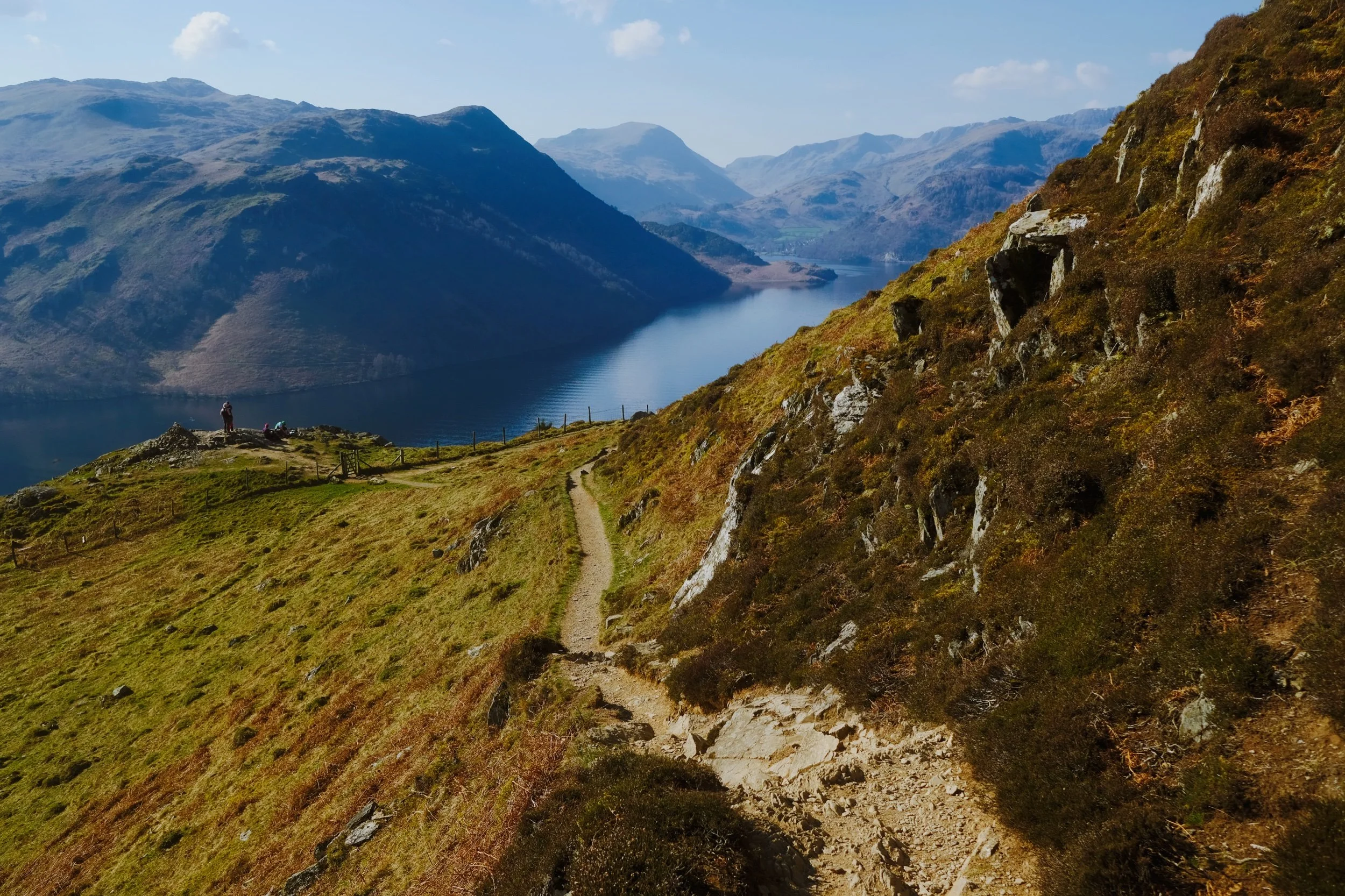
After the summit it was a simple task of following the narrow winding footpath around Gowbarrow’s northern and eastern shoulder. In places, the drop from the footpath is rather precipitous.
Lisabet pauses to check on my progress, so I snapped this composition. Truly glory awaits us around the corner…
Hundreds of metres below us the Ullswater Steamers begin the first of many travels across the lake.
And there it is. In my view, one of the grandest views in all of the Lake District. Ullswater and the Helvellyn fells.
Who can resist pausing for a rest and some photos, with a view like that?
North Pennines Waterfalls, County Durham, Summer
Woohoo for a week off! With the Lake District as rammed as it is at the moment, let’s go somewhere a l’al bit different.
Woohoo for a week off! With the Lake District as rammed as it is at the moment, let’s go somewhere and l’al bit different.
The North Pennines AONB (Area of Outstanding Natural Beauty) is a favourite of ours but remains relatively untouched by us. We’ve explored arguably the jewel of the North Pennines, High Cup Nick, many times. But another absolutely stunning part of the area is the three main waterfalls: High Force, Low Force, and Cauldron Snout.
Long-time followers of this blog may remember our last excursion to High Force and Low Force, last year. The two waterfalls are a geology student’s dream and truly spectacular. But the third waterfall, Cauldron Snout, is often missed out on compared to the other two. That’s because it’s many miles further up the River Tees, near Cow Green Reservoir. Like High Force and Low Force, Cauldron Snout is the result of the outflow of Cow Green Reservoir passing over the whin sill; a layer of prehistoric super-hard dolerite volcanic rock that has left pillars and columns. The waterfall has eroded the softer rock around, leaving the harder columns of whin sill standing.
Cauldron Snout “only” drops about 60 m, all in all, but does so steeply down 180 m of the gorge, making it one of the longest waterfalls in England. The last time we visited it was many years ago in between Christmas and New Year, and a lot of the rock around the waterfall was covered in ice, making it a treacherous task to navigate. This time, we managed to scramble all the down alongside the waterfall. It was immense.
All photos shot on my Fujifilm X-T2 using my three prime lenses: a Samyang 35mm f/1.2, a Laowa 9mm f/2.8, and an adapted Pentax SMC 55mm f/2.0. Images developed using one of RNI Film’s Kodachrome profiles, finished in Affinity Photo.
Low Force is probably the easiest of the three to access, being less than a kilometre’s walk from the Bowlees Visitor Centre. Regardless, it’s an impressive sight and sound.
My lovely Lisabet, already on the case and getting some compositions in.
I clambered around the columns and cliffs of whin sill to get to the northern bank of the Tees for this view of the main falls of Low Force. The morning’s light was wonderful and I didn’t want to miss out.
The twin falls of Low Force. Not necessarily all that tall, but powerful and loud.
The conditions and light were beautiful. Not too harsh. Autumn’s definitely on the way.
One gentleman decided that a dip in the waterfall was in order.
Fair play to him.
The Pennine Way heads along this footbridge, which crosses the River Tees below. It’s an old ‘un, too, so all the signage requests people cross it one at a time.
The lower aspect of Low Force shot from the southern banks of the Tees after we crossed the bridge.
After I spotted this young lass climbing the statues, I think she looked rather… sheepish?
A tighter composition of the main falls of Low Force, trying to convey the sheer power of these waterfalls. The redness in the water comes from all the peat the river carries from the high moorlands of the North Pennines.
Looking back at the northern bank of the River Tees, with more people finding their now to the waterfalls. Best get a move on.
Lisabet doing her best to capture all the splendour around her.
Love all the signs of autumn starting to appear.
Looking forward to all the rusty colours of autumnal ferns.
After trekking the Pennine Way along the southern side of the River Tees, we crossed another old footbridge and took these steep steps up towards the road. A visit to High Force beckoned us.
The woodland above the Tees is still lush.
After paying our entrance fee (£2 per adult, very reasonable), we followed the path through the woodlands of the Raby Estate. Already, we could hear the booming sound of the giant waterfall, High Force.
The first glimpse of High Force and the gorge it’s created. The excitement builds…
And there she is, plunging 70 ft off a cliff into the deep pool below. What a sight.
We scrambled down to the boulder field left behind by the receding waterfall, each of us seeking our own photographic compositions of the waterfall.
Of course, mine predominately featured all the wonderful shapes of the boulders.
After thousands and thousands of years, as the waterfall carves its way back up the River Tees, it’s left behind boulder with fascinating shapes and textures.
Plenty of other folk were clambering around the boulders for better views of the awesome High Force.
Nature makes you feel closer.
Due to the COVID-19 Pandemic, the High Force trail is a one-way system now, so we hiked up the steep steps out of the gorge and navigated through the Raby Estate woods back to the car. My lovely Lisabet, looking as stunning as ever.
Upper Teesdale has a similar “feel” to a Yorkshire Dales valley, to me.
After a break for lunch, we drove a few miles west and parked at Cow Green Reservoir, seeking out Cauldron Snout. Along the way, views across the reservoir can be had of Meldon Hill (767 m/2,517 ft).
We crossed the dam for views over the reservoir and below to the Tees. Clouds of midges were out in full force.
Looking down onto the Tees from the top of the dam. You can just make out to the left the top of Cauldron Snout before it crashes down into the valley.
Cow Green Reservoir was constructed in the late 1960s to supply the industries of Teeside with a constant supply of water.
The reservoir essentially acts as a river regulator, ensuring the River Tees is always flowing with water even during dry conditions.
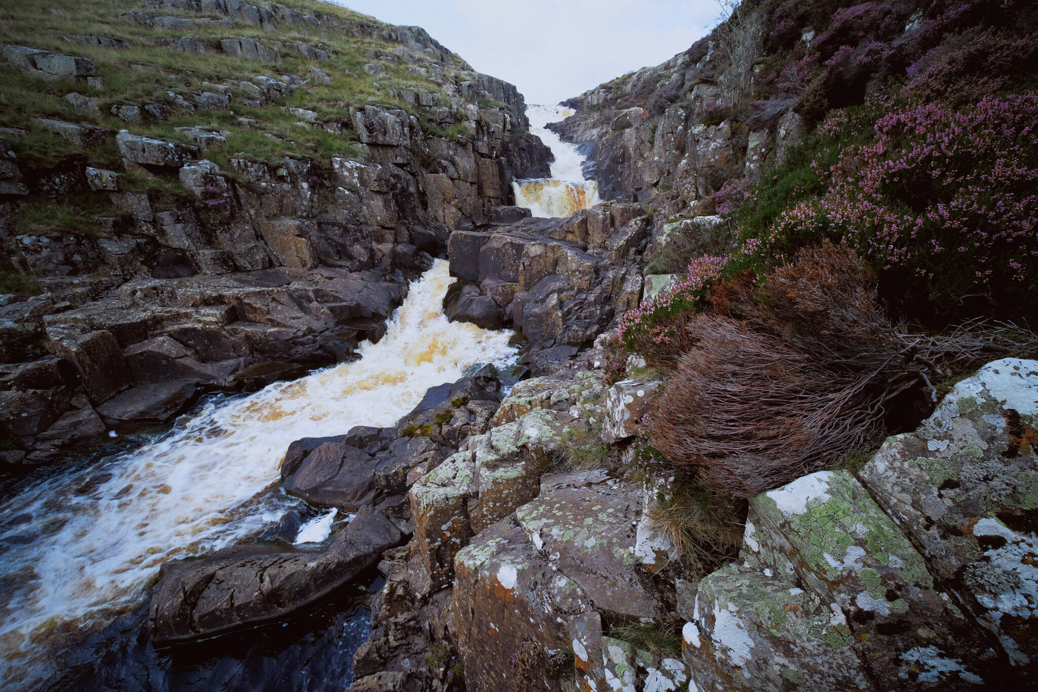
And here’s the top of Cauldron Snout. The Pennine Way is to left, but it isn’t really a “path” as such as navigating and scrambling down the side of the gorge created by the waterfall.
But doing so enables you to get right next to the falls for cracking views like this. A man perched at the top of the falls helps provide a sense of scale.
With the heather in bloom, they provided wonderful pops of colour around the waterfall.
Scrambling down the gorge was exhilarating, and definitely something that would not have been possible for my condition 5-years ago.
As the gorge sheltered us from the wind, this provided the necessary moist and still conditions for clouds of midges to form everywhere. They duly took advantage and started ravaging our bare flesh.
Near the bottom of Cauldron Snout now, and we can start to understand the scale of these falls.
The bottom of Cauldron Snout, which climaxes with this beautiful fanned curtain of a waterfall.
Gowbarrow Fell, Lake District, Spring
Spring conditions are somewhat changeable at the moment.
Spring conditions are somewhat changeable at the moment.
Lisabet and I have been somewhat fortunate with this week-long extended Easter break. The first few days were relatively balmy for Cumbria, peaking at around 15°C. By Good Friday an “arctic blast” was arriving from the north, and temperatures quickly dropped by around 10°C or so. Despite the swing in climate conditions, the sky has remained consistently free of clouds.
This changed today and forecasts were warning of intermittent, and possibly heavy, snow squalls drifting through the county. We had originally planned for a hike around one of our favourite valleys, Mallerstang, but a sudden rush of inspiration from Lisabet meant heading up and over Kirkstone Pass towards Ullswater.
We quickly charted a route above the epic Aira Force, stopping to pay a quick visit to High Force, then out of the woods beyond High Cascades and up onto the shoulder of Gowbarrow Fell (481 m/1,578 ft). Then we would summit at Airy Crag, observe the Ullswater Way all the way around the eastern shoulder of the fell, and follow the track down the hill’s southern face, with sweeping views of Ullswater and the Helvellyn fells all the way.
What followed was an experience that ranked in our top three fell walks of all time. Absolutely glorious.
The only downside is that not long after starting the ascent up Gowbarrow Fell, my camera ran out of battery charge. I very much assumed I had enough charge, but temperatures barely above freezing point quickly saw to that. Thankfully my Google Pixel 3XL can shoot RAW files, which I relied on for the rest of the hike.
This is a fell we will definitely be revisiting, especially in late-summer when all the lovely pink heather will be blooming.
Photos shot on my Fujifilm X-T2, using a Samyang 35mm f/1.2 lens and Laowa 9mm f/2.8 lens, as well as my Google Pixel 3XL. Developed using RNI’s Kodachrome film profiles.
We parked in a National Trust lay-by not too far from Glencoyne Bay. I had a quick wander down towards the shore of Ullswater, knowing that at this time of year there’d be daffodils aplenty nearby. I weren’t wrong.
It was a gusty day, with the thermometer rarely reaching above 4°C. The wind chill factor pushed that number below freezing, feeling very raw on the face. Fortunately it made light conditions very changeable, which I always really enjoy. I adore watching the light scan and caress the fells.
In the woods of the Aira Force gorge, with one of my favourite trees in view. It puts me in mind of a pair of tights sagging down to the ankles.
Understandably the footpath around Aira Force woods is one way, which we made short work of. From the small stone bridge above the waterfall, my 9mm ultra wide lens allows an expansive and unique view of the drop down to the plunge pool and beyond. The usual viewing area below the waterfall is currently blocked off, as the National Trust who own the land here are currently working on a new and stronger viewing platform.
Beyond the main show that is Aira Force, one can take a quick detour off the main footpath to get this view of High Force.
This photo marks the change from my Fujifilm X-T2 to my Google Pixel 3XL. As we ascended up the western shoulder of Gowbarrow Fell, it became increasingly difficult to stop looking back at the evolving panorama behind us. Ullswater, and the Patterdale and Helvellyn fells.
Not only that, the higher we climbed the more we could see of the Northern Fells. Here I utilised the wooden marker as a compositional aid, pointing towards Blencathra (868 m/2,848 ft).
And eventually… summit! This is Airy Crag, the peak of Gowbarrow Fell. The views are expansive and exceptional; from here it’s easy to pick out not just the northern fells of the Lake District but also right across the Eden valley to the Northern Pennines. That also meant we could see the dark clouds steadily moving towards us.
The view from the summit towards the Helvellyn massif.
And the northern fells of Blencathra and Skiddaw.
As we started to round Gowbarrow’s eastern shoulder, the snow squalls came thick and fast.
But whenever a snow squall did pass, we were immediately rewarded with a burst of sun light.
Near Collier Hagg we found a nice crag to sit on and eat some lunch whilst admiring the views. Looking east across the Eden valley, it was easy to make out the North Pennines getting absolutely hammered by the rain and snow.
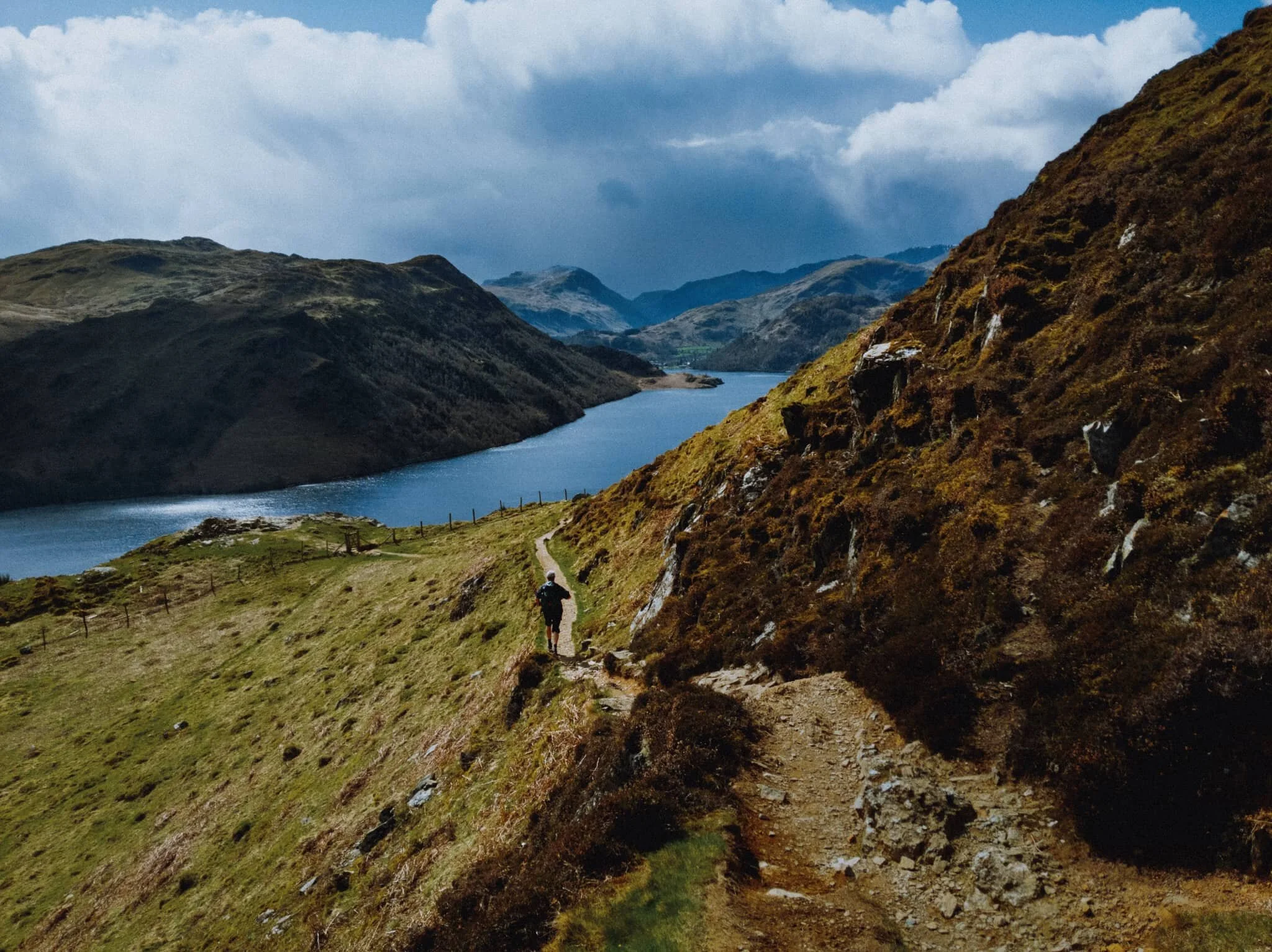
As we started to make our way towards the southern face of Gowbarrow, near the Memorial Seat, this view opened up that quite literally made me shout an expletive! A moment Lisabet and I will never forget.
I had to take a vertical composition as well.
We came off the Ullswater Way to admire the views down Ullswater towards the Patterdale and Helvellyn fells. Truly incredible scenes.
My poor Pixel’s attempt at a “zoom” photo. It’ll do.

Teesdale Waterfalls, North Pennines, Autumn
On the final day of our mini-break we decided to enjoy a proper good hike around Upper Teesdale.
On the final day of our mini-break we decided to enjoy a proper good hike around Upper Teesdale.
We’ve been to Upper Teesdale a few times before, mostly for quick excursions to the epic High Force waterfall. But now we’re fitter and healthier, we felt capable of more, so we parked at the Bowlees Visitor Centre and took in lots of waterfalls around Upper Teesdale.
Upper Teesdale sits within Country Durham near the border with Cumbria, and is also entirely within the North Pennines Area Of Outstanding Natural Beauty (AONB). As well as enjoying the protections of being with in the AONB it’s also a SSSI (Site of Special Scientific Interest), for its diverse range of habitats and being one of the most important botanical areas in Britain; Upper Teesdale features a vast mixture of nationally rare flora, including some that are essentially relicts of the last glacial era.
As cool as all this is, Lisabet and I were here for waterfalls and vast open landscapes. Within a relatively small area we were able to visit Summerhill Force (in Gibson’s Cave), Low Force, High Force (from above), and Bleabeck Force. The area is a veritable treasure trove of watery delights!
All photos shot on a Fujifilm X-T2 with a Fujinon XF 18–55mm f/2.8–4.0 using a customised Classic Chrome film profile.
A few metres from the Bowlees car park we chanced upon our first waterfall, which we initially thought was Summerhill Force itself. A pleasant little drop.
After trekking back to the Visitor Centre, then across the road and down into the woods, the canopy opens up and we are treated to the spectacular site of Low Force.
In actuality, half a kilometre upstream, this is Summerhill Force, which drops over a large limestone overhang known as Gibson’s Cave.
The rock here is Whin Sill, the exact same rock found at the head of High Cup Nick (you can read about our hike up to this epic valley here). The rock is extremely hard and resists erosion, forming columns and tessellating block pavements.
Not one of the tallest waterfalls, at only 18 ft high, but Low Force is certainly powerful and a damn impressive site.
Around the falls, the woods start changing colour. Autumn is coming.
You can more clearly see the rigid column structures that the Whin Sill rock is known for. Fellow hikers in the background provide a good sense of scale.
What I love about Low Force is that it’s very easy to get right next to the falls, and really feel the roaring power of the water as it crashes down, carving out chunks of land.
The upper section of Low Force. Just a delightful scene, on what turned out to be a beautiful day of clear light.
Soft light in the woods around Low Force.
After crossing Wynch Bridge (carefully, it’s a suspension bridge built in the 1830s), you can catch site of another set of cascades with Low Force in the distance.
Low Force, this time from its southern banks, with soft light highlighting the central pillar that separates the falls.
On our way to High Force I catch some Swaledale sheep mucking around on a raised boulder.
The epic High Force, and my first time photographing the waterfall from above. The falls plunge a sheer 70ft through the hard Whin Sill rock in the area. A truly awe-inspiring site.
Looking straight down the sheer 70 ft drop of High Force. Definitely a weak-knee moment.
From above High Force and looking back into the gorge the waterfall has been cutting for thousands of years.
We sat right next to the Tees above High Force for our picnic lunch. The red-brown colour in the water is from all the peat the river carries from the moorland of the North Pennines.
Families enjoy the sites and sounds of the Tees, hopping between boulders or pausing for food and drink.
Beyond High Force the landscape of Upper Teesdale really opens up, and we can make out some of the peaks of the North Pennines.
Our final destination in Upper Teesdale: Bleabeck Force.
It was lovely to see so much heather (Calluna vulgaris) in Upper Teesdale.
A dead Juniper tree (Juniperus communis) enveloped by a boulder.
A somewhat rundown farmstead, still apparently in habitation.

Aira Force, Lake District, Summer
The weekend has been very wet.
The weekend has been very wet.
The Met Office have stated that, between 10:00am Sunday 28/6/20 and 10:00am Monday 29/6/20, Honister Pass recorded 212.8 mm of rain, “provisionally a new UK June daily rainfall record”.
Honister Pass is in the Lake District. It’s been very wet.
But after some investigations Lisabet and I did spot a gap in the rain towards the Eastern Lake District. So, after work, into the car we went and nipped up and over Kirkstone Pass for an energetic hike around Aira Force.
We were rewarded with a lush gorge and waterfalls absolutely roaring with water.
All photos shot on a Fujifilm X-T2 with a 16–50mm f/3.5–5.6 lens using a customised Velvia film simulation.
Heading up Kirkstone Pass with the cloud shelf just starting to lift off the fells.
And heading down 't’other side of Kirkstone Pass, Place Fell (657 m/2,156 ft) in the distance with Brotherswater underneath it.
Ambitious young ‘uns hiking back up Kirkstone Pass.
The trunk of a Monkey Puzzle tree (Araucaria araucana), looking like wrinkly “skin” that’s sagging with age.
Looking down into the gorge from the bridge above Aira Force. The sheer wall of sounds and flying spray everywhere was immense.
Looking straight down the sheer drop of Aira Force.
Further upstream along Aira Beck you can find some more falls. This is High Force, more of a series of powerful cascades. Still gorgeous, especially in this soft light.
Zooming in on those details of High Force.
Aira Force, in full spate after a weekend of heavy rain. The waterfall is probably one of the Lake District’s most famous, dropping 70ft in two parts with a picturesque packhorse bridge arching above it.
As I’ve written on this blog many times before, the word “force” comes the Old Norse fors meaning “waterfall”. The word “Aira” comes from two Old Norse words: eyrr, which means a gravel bank, and á, which is a river, giving us “river at the gravel bank” and the full name meaning “the waterfall on gravel-bank river”.
We popped out of the Aira Force gorge a little early to go for a quick wander up Gowbarrow Fell. There were some views of Ullswater and its fells that I wanted to show Lisabet. And boy what a view we got.