
Feizor, Yorkshire Dales, Spring
I don’t explore the Yorkshire Dales enough.
I don’t explore the Yorkshire Dales enough.
After finally getting over my post-Skye mourning and depression period, it seemed like spring finally arrived in Northern England.
Aware of how busy the Lake District would be, we instead ventured east to the Yorkshire Dales. We quickly realised that we hadn’t explored the Feizor area of the Dales in a long time, like maybe 7-years or so. Time to fix that.
Feizor (pronounced “FAY-zer”) is a tiny l’al hamlet between Austwick and Settle, and easy to miss. Home to a few houses, a farm, and the famous Elaine’s Tearoom, rising high above the hamlet are the limestone fells of Pott Scar and Smearsett Scar. These were the focus of the day’s hike and exploration.
Pott Scar and Smearsett Scar were beautiful examples of limestone karst landscapes, but they also offered immense views to either the back of Ingleborough or the shapely Pen-y-ghent.
A super day.
All photos taken on my Sony α7ii using my Sony FE 28–70mm f3.5–5.6 OSS and Vivitar “Series 1” 70–210mm f2.8–4.0 zoom lenses. RAWs developed in Lightroom, then tweaked and finalised in Photoshop.
Feizor, Yorkshire Dales, Spring by Ian Cylkowski is licensed under CC BY-NC-SA 4.0![]()
![]()
![]()
![]()
A near-timeless scene in the heart of Feizor. Old stone buildings, dry stone walls, foliage everywhere, and the fells rising up behind.
This quaint scene, complete with old water pump, was something I couldn’t resist making a composition of.
Round the back of Pott Scar, before ascending, one can enjoy expansive views towards Pen-y-ghent, one of the Three Peaks of the Yorkshire Dales.
The squelchy slog up the fell was rewarded with beautiful views from Pott Scar towards Smearsett Scar.
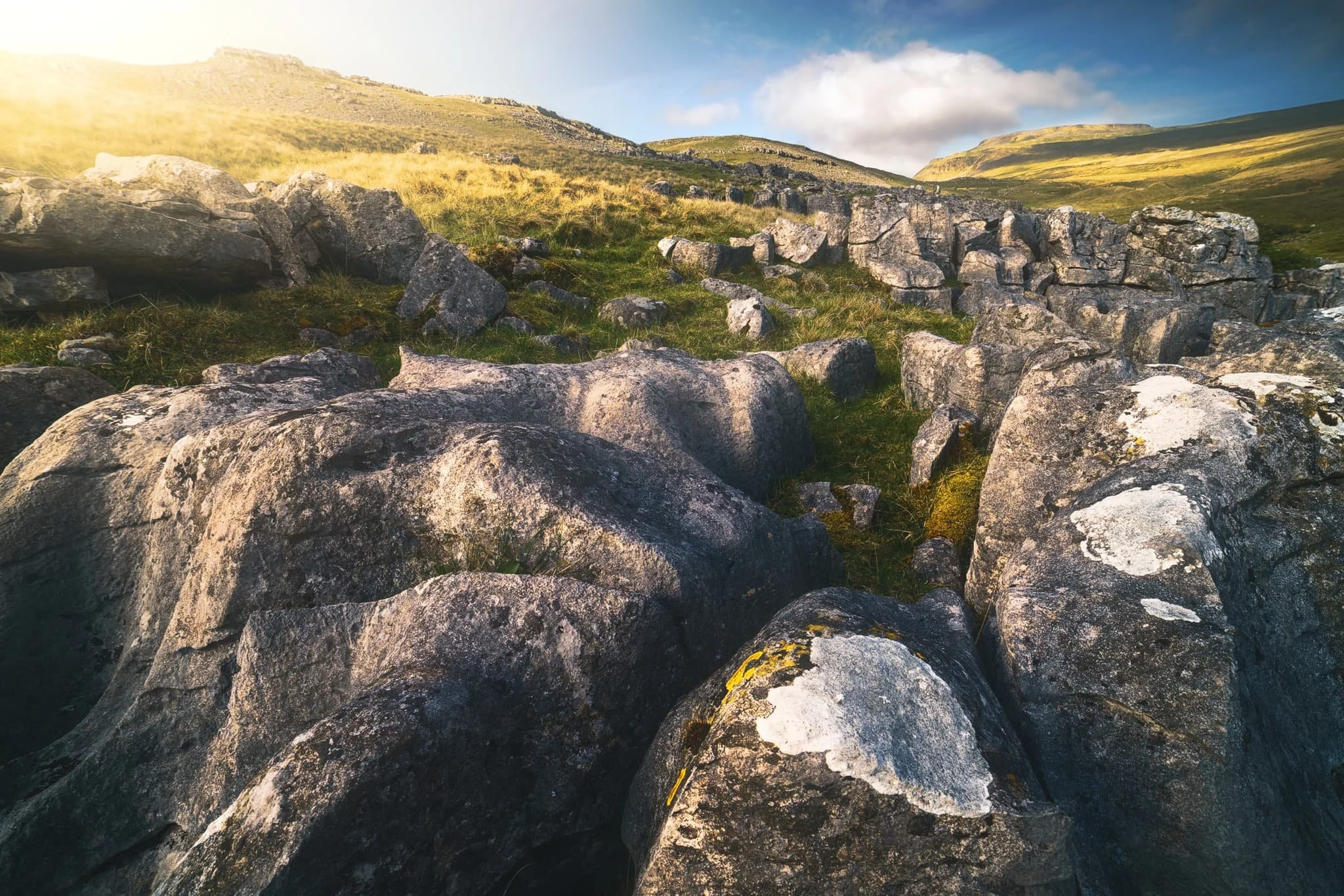
Fin-like clints and grikes of limestone made for a nice leading line towards Smearsett Scar.
Nearer the edge of Pott Scar, I focus stacked these bare limestone edges as they curved off into the distance towards Smearsett Scar.
From the summit of Smearsett Scar, the full extent and shape of Pott Scar is revealed. The day was brightening up too, albeit with a haze.
The summit of Smearsett Scar offers a bounty of limestone clints and grikes that I want to make compositions of.
Another variation from the summit of Smearsett Scar, using the exposed clints and grikes as a leading line towards Pott Scar.
Back down the back of Pott Scar, drafting clouds cast dancing shadows across Moughton Scar and the back of mighty Ingleborough, another one of the Three Peaks of the Yorkshire Dales.
Plenty of teeny Swaledale lambs about, hastily retreating back to their mums as we followed the track back to Feizor.
The single road that winds its way through Feizor.
A super-zoomed in composition of the back of Ingleborough, taken from the small lane between Feizor and Buck Haw Brow, light dancing across the karst features of the land.
Did you enjoy these photos?

Kingsdale, Yorkshire Dales, Autumn
Flexibility can lead to great things.
Flexibility can lead to great things.
We started a promising Saturday morning with a plan to hike up the highest peak in the Yorkshire Dales: Whernside (736 m/2,415 ft).
It would definitely be the highest peak we’ve ever ascended but we were planning to “cheat” a little bit. Below Whernside’s western flank is a valley called Kingsdale. There’s a road that runs from the south, near Ingleton, through and over Kingsdale before dropping back down into Dentdale. This road enjoys a few large passing places, one of which is near the summit of the road at 468 m a.s.l. In theory, we could park at the passing place and hike the minor trail up Whernside’s western flank to reach the summit, with only 300 m of actual ascent needed.
We didn’t go for it in the end. Parking in passing places is generally a no-no, and the trail and landscape around Whernside’s western flank looked rather boggy.
Instead, we drove back down to the valley bottom of Kingsdale and stopped at an actual parking place. Here we elected for a hike up Kingsdale’s magnificent limestone fellside to locate the magnificent Cheese Press Stones.
It turned out to be a great idea on a beautiful day.
All photos shot on my Sony α7ii using my Sony FE 28–70mm f3.5–5.6 OSS zoom lens. RAWs developed in Lightroom using RNI Films’ Kodachrome film profiles, finalised in Photoshop.
Kingsdale, Yorkshire Dales, Autumn by Ian Cylkowski is licensed under CC BY-NC-SA 4.0![]()
![]()
![]()
![]()
Straight away from our little parking bay, the views across to Twistleton Scar and Ingleborough were magnificent. They were only going to get better.
The road north through Kingsdale, with the valley’s fantastic scar looming directly above. The main scar above the road is known as Keld Head Scar. The start of the hike heads up the fellside just as the road veers right.
Part way up Keld Head Scar, and a single tree growing out of a limestone boulder provides a nice subject with Whernside in the distance.
As we clamber through the irregular clints and grikes of limestone, and navigate the occasional boulder, Ingleborough emerges from above Twistleton Scar. An old drystone sheep pen provides a nice foreground subject contrast against the fell in the distance.
A large cluster of limestone boulders, no doubt dumped in position by the last Ice Age, provide a nice foreground focal point. They also, happily, seem to “point” towards Ingleborough.
Finally, after a fairly challenging hike and scramble through Keld Head Scar, we emerged onto a limestone plateau where we easily spotted the Cheese Press Stones. These are a pair of giant limestone boulders, probably deposited here after the last Ice Age. Why are they called the “Cheese Press Stones”? No idea.
The boulder on the left is a good 9–10 ft tall. Some estimate its weight at around 15 tons. Here, an obvious composition is hard to ignore, using the two boulders to centre and frame Ingleborough.
A few yards away, I spot another interesting limestone boulder, which appears to me almost like a cracked open egg.
Further up the plateau, a group of large limestone boulders attract my attention. I line a composition, attempting to fill the frame with them whilst keeping Whernside visible in the distance.
I circle around the cluster of boulders to find a composition featured Ingleborough. It means shooting directly into the sun, but thankfully Sony RAW files are incredible flexible.
I locate Lisabet near North End Scar, perched atop a small crag, happily editing her photos. In the distance, the Forest of Bowland is just about visible.
The way back involves navigating this ankle-breaking limestone pavement to relocate the minor trail, which takes you below North End Scar, past Tow Scar, and back down to the road.
Beneath North End Scar’s western edge, the layering and striations of the limestone is fascinating.
I am a sucker for a good drystone wall composition.
The criss-crossing and weaving of the valley and its various limestone scars and layers provide me a delightful photo with Whernside high in the distance.
Nearly back at the car, with the limestone scar of Kingsdale’s western edge in full display. A beautifully sculpted glacial valley.
Did you enjoy these photos?
Crina Bottom, Yorkshire Dales, Spring
After returning from North Wales, but before returning to work, Lisabet and I decided on a wee spring jaunt up to Crina Bottom.
After returning from North Wales, but before returning to work, Lisabet and I decided on a wee spring jaunt up to Crina Bottom.
Crina Bottom is a 400-year old farmstead situated above Ingleton and below the peak of Ingleborough. The route to summit Ingleborough from Ingleton via Crina Bottom is one of the most popular trails to top this famous peak. As such, it’s nicely paved all the way, allowing for easy hiking as the views become increasingly gorgeous.
Once at Crina Bottom, one can enjoy a ridiculous view straight to the flat-topped mountain that is Ingleborough. Just beyond the farmstead, limestone clints and grikes are a photographer’s paradise for compositions.
Plus, we had gorgeous light too.
All photos taken on my Sony α7ii using my Sony FE 28–70mm f3.5–5.6 OSS zoom and Rokinon 14mm f2.8 ED AS IF UMC ultra-wide prime lenses. RAWs developed in Lightroom for iPad, then edited and finalised in Affinity Photo 2 for iPad.
Crina Bottom, Yorkshire Dales, Spring by Ian Cylkowski is licensed under CC BY-NC-SA 4.0![]()
![]()
![]()
![]()
Hiking up Fell Lane to Crina Bottom, a glorious day made shooting this landscape impossible to ignore.
Crina Bottom farmstead with mighty Ingleborough rising above in the distance. Not a bad spot to call home, eh?
Life… finds a way.
Above the farmstead, one can a lovely patch of limestone clints and grikes to play around with and try out some compositions.
Lisabet, perched on a limestone clint, enjoying the view to Ingleborough.
Evening sun bursts from behind a cloud, pulling out all the delicious textures and forms of the limestone rocks, and brushing a paint stroke across the face of Ingleborough.
Did you enjoy these photos?
Ingleton Falls, Yorkshire Dales, Spring
My first set of images made with my new Sony a7II.
My first set of images made with my new Sony a7II.
A wee bit of backstory is needed.
My 40th birthday is fast approaching (if you’re at all curious, it’s on the 25th April). That’s right, the Big Four Oh.
My Dad had got wind of the notion that, ultimately, if I could ever upgrade my camera it would be to one with a bigger sensor and in-built image stabilisation.
Cue a week or so ago and Dad arrives at my house with a Sony a7II. In mint condition. Cognisant that I had a Laowa 9mm ultra-wide lens that wouldn’t properly work on a full-frame body, Dad had also sorted me out with a new equivalent ultra-wide for the Sony: a Rokinon 14mm f/2.8 ED AS IF UMC. And a new adaptor so I could continue to use my 1980s Vivitar lenses.
In other words, he’s pretty awesome.
A few days later, we had a day out together and decided on Ingleton in the Yorkshire Dales and its gorgeous Waterfalls Trail. Time to properly test out the Sony and its image stabilisation capabilities.
It did not disappoint. My ultra-wide at ISO100 and f/8 was able to get down to 1/10sec exposure with no camera shake. Amazing.
All images taken on my Sony a7II using my Vivitar “Series 1” 28–105mm f2.8–3.8 zoom, Vivitar “Series 1” 70–210mm f/2.8–4.0 zoom, and Rokinon 14mm f/2.8 ultra-wide prime lenses. RAWs developed in Capture One for iPad, then edited and finalised in Affinity Photo 2 for iPad.
The first composition on the trail that catches my eye, I quickly attach my Rokinon 14mm ultra-wide and start getting to grips with my new Sony and how it works.
The first of the major falls on the trail, Pecca Twin Falls. With my 14mm ultra-wide at ISO100 and f8, I was able to get an exposure down to 1/10sec with no camera shake, allowing for water motion. Fantastic.
The trail continues alongside and above the falls. We were by no means alone; Ingleton Falls trail was very busy that day.
The top section of Pecca Falls is a tight squeeze, but I still walked away extremely happy with how this turned out.
Arguably the main “show piece” of the entire trail: Thornton Force. I realised it’d been a while since I’d done the Ingleton Falls trail because the landscape had changed. For a start, a second waterfall was cascading down the left. Additionally, it was quite easy to crawl along a ledge to get behind the curtain of water, but those rocks seemed to have washed away.
This year’s lambs, happily dosing and mucking about in the warm spring sun.
Ingleborough’s flat top catching the light, rising high above the valley floor and its inhabitants.
Did you enjoy these photos?

Clapham & Trow Gill, Yorkshire Dales, Winter
The seasons progress and the weather is changing.
The seasons progress and the weather is changing.
After a month of near-constant rain interspersed with heavy fog, a high-pressure system is moving in and bringing with it clearer skies and lower temperatures.
Winter has arrived.
On Saturday we were greeted with clear skies and a biting wind. We ventured into the Yorkshire Dales—Clapham, to be precise—for a hike up towards and above Trow Gill. We would then scramble through the gill to get to the high moorland above for extensive panoramic views.
It were a crackin’ day for it.
All photos taken on my Fujifilm X-T2 using my Vivitar “Series 1” 28–105mm f2.8–3.8 zoom and Laowa 9mm f2.8 prime lenses. Developed in Capture One with the “Classic Chrome” Fujfilm simulation, finalised in Affinity Photo 2 for iPad,
Clapham & Trow Gill, Yorkshire Dales, Winter by Ian Cylkowski is licensed under CC BY-NC-SA 4.0![]()
![]()
![]()
![]()
It’d been a long time since I visited Clapham. In fact, I can recall the last time because I was still shooting with a Nikon D7000 that was nearly permanently attached to a tripod. This means the last time I was at Clapham was around 2016. Wow.
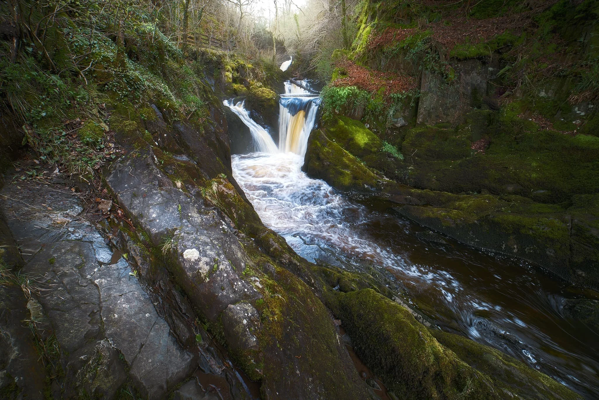
Here is something I do not remember from our last visit: a friggin’ waterfall! Turns out there’s been a lot of conservation work in recent years, some of which involved clearing the riverside bank here of snowberries, which was obscuring views of this waterfall.
The last of the year’s autumn colours in beautiful winter light.
Clapham Falls is a man-made waterfall, constructed as a three-tier drop underneath a bridge in the early 19th century by the Farrer family. They’ve long had established ties to the village and the 19th century saw a lot of landscaping and remodelling of the village.
This is something I wasn’t expecting to see in winter: flowering plants! I think this might be Mahonia japonica, which is apparently native to Taiwan. It flowers in winter through to spring.
After working our way up and through Clapdale Wood and past the famous Ingleborough Show Cave we finally arrived at the entrance to Trow Gill.
Trow Gill is an immense ravine with 200ft high cliff walls. It was once the site of a massive waterfall, much like Troller’s Gill near Appletreewick.
We scrambled up the gill to access the high moorland above. From here, looking back down, I start to imagine what the waterfall would’ve looked like and the forces involved in sculpting this ravine. Immense.
The beck which once flowed through here as a raging waterfall begins life on the eastern slopes of Ingleborough. At some point in the distant past the beck no longer reached this ravine, instead falling underground near Ingleborough down a giant cavern now known as Gaping Gill. It is technically England’s single biggest drop waterfall, even though it falls underground.
Scrambling up and out of the gill, the land begins to open up and we can start to glimpse the eastern aspect of Ingleborough.
Above us, to the north, a limestone scar is drenched in winter light whilst the sky is ominously dark and cold.
The more unfamiliar view of Ingleborough. To the left is Little Ingleborough, with the main fell to the right. Though the trail continues on towards the fells, we decided to loop back and reconnect with the Pennine Bridleway.
Zooming right in on Little Ingleborough. You can just make out the tiny figures following the trail up the fell.
Up on the moorlands above Clapham, the views massively open up. Beyond Thwaite Scar we could make out the distant yet distinct shape of Pendle Hill, all the way in East Lancashire.
Even more impressively, Pen-y-Ghent was clear as a bell and looking spectacular.
The rolling landscape of the Yorkshire Dales, interspersed with karst limestone formations such as limestone pavements, scars, ridges, and of course the distinctive isolated fells.
Back on the Penine Bridleway south to Clapham, Thwaite Scar receives some late afternoon golden light.
Before dropping down to the village, I nab one final composition of Robin Proctor’s Scar—a sheer cliff face—being bathed in golden winter light.
Did you enjoy these photos?
Hull Pot, Yorkshire Dales, Summer
There’s something awe-inspiring yet slightly unnerving about a giant hole in the ground.
There’s something awe-inspiring yet slightly unnerving about a giant hole in the ground.
The Yorkshire Dales is known for many things: beautiful waterfalls everywhere, isolated peaks, perfectly sculpted valleys… and also, caves. It’s home to some of the most extensive cave systems in the UK.
This is largely because of the underlying geology. Most of the Yorkshire Dales features Carboniferous limestone, which is soluble in weakly acidic water, such as rain. As a result, millennia of glacial action and weather erosion has given rise to a karst landscape dotted with deep potholes that lead down into a myriad of cave systems. It’s in the Yorkshire Dales that the UK’s longest cave system—and the world’s 13th longest—can be found: the Three Counties system, which is 53 miles long.
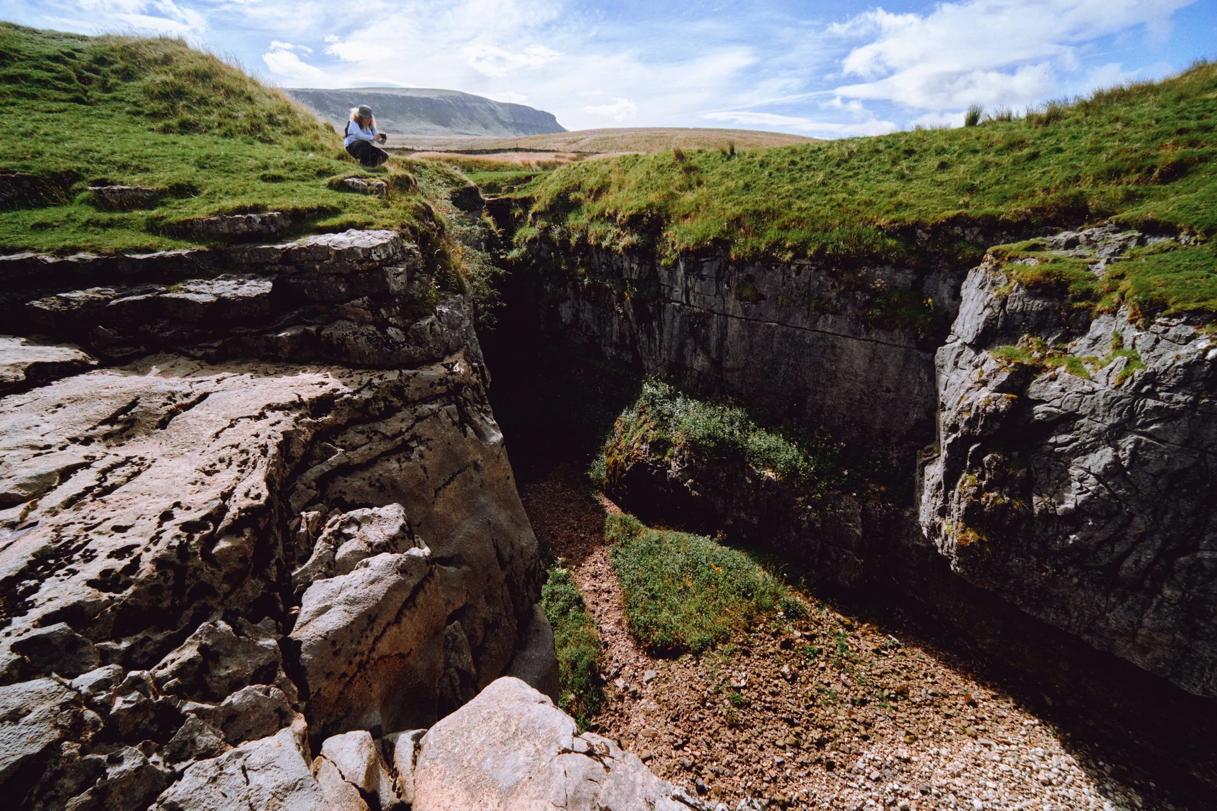
Down the western flank of Pen-y-Ghent, one of the Three Peaks of the Yorkshire Dales, one can find a 60ft deep chasm in the earth called Hull Pot. It is the remnant of a cave with a collapsed roof.
It is extremely impressive.
All photos taken on my Fujifilm X-T2 using my Vivitar “Series 1” 28–105mm f2.8–f3.8 zoom lens and a Laowa 9mm f/2.8 prime ultra-wide. RAW files were converted with Capture One for iPad, developed in RNI Films, and finished in Affinity Photo for iPad.
Hull Pot, Yorkshire Dales, Summer by Ian Cylkowski is licensed under CC BY-NC-SA 4.0![]()
![]()
![]()
![]()
The route to Hull Pot is simple enough and starts at the small village of Horton in Ribblesdale. Heading up the Pennine Bridleway, views quickly open up looking back to Ingleborough.
The characteristic barns of the Yorkshire Dales, some in a better condition than others.
The first glimpse of Pen-y-Ghent’s unmistakeable shape comes into view.
The clouds above us were ridiculously pretty, ranging from low-level fluffy clouds, high-level streaky ones and even some lenticular in between.
A dilapidated barn connecting to the drystone wall provides a perfect Yorkshire Dales subject for this gorgeous composition.
Though not busy, there were still plenty of people on the trail. Mostly heading to, and from, Pen-y-Ghent.
It’s always important to check the view behind you occasionally. Beyond the winding drystone walls, Smearsett Scar rises above the karst landscape.
As the morning progresses the clouds burn off, revealing the flat-topped Ingleborough on the left with Simon Fell on the right.
Painterly clouds like a mad genius’ brush strokes decorate the skies as we advance along the bridleway.
Around Horton Scar the path averages out in height at around the 400m asl mark. The light picked out the folds and ruffles in the landscape.
Fellow hikers make their way back down to the valley bottom after climbing Pen-y-Ghent.
The western aspect of Pen-y-Ghent with its famous brow and “nose”. I enjoyed making this Z in the landscape using the drystone wall as it climbs up Horton Scar.
A female Northern Wheatear (Oenanthe oenanthe), seemingly unfazed by our presence and appreciation.
Another extinct waterfall, located at the head of Horton Scar. There are many of these in the Yorkshire Dales. The rivers that feed these waterfalls usually break down the limestone riverbeds and valleys they create before heading underground, leaving the waterfall to dry up.
We arrive at Hull Pot. With my 9mm ultra-wide lens equipped, I shot this expansive view of the 60ft chasm from near its eastern edge. From the edge you can actually hear the rushing of a waterfall.
This is Hull Pot Beck. In times gone this river would flow over the lip of Hull Pot, crashing down as a large waterfall. These days it’s mostly dry except during times of heavy rainfall, as the water now sinks underground further up the river.
Lisabet and I played around the edge of the “waterfall” and Hull Pot, finding compositions. In the distance is Pen-y-Ghent, always watching.
Weird to think that this composition would, in ancient times, mean standing at the precipice of a large roaring waterfall.
As we move into late summer, beautiful pink and magenta heather starts to bloom.
My favourite composition in the area: the chasm of Hull Pot with Pen-y-Ghent rising high above.
The 50ft+ sheer walls of Hull Pot. In the darkness there is actually a waterfall that rushes out of the caves at the bottom of this chasm.
After a spot of lunch perched on the lip of Hull Pot’s eastern end, I snap one last photo of the chasm before heading back.
The Pennine Bridleway continues up towards Pen-y-Ghent, the common route to summit the fell.
The atmosphere was wonderfully clear. From above Horton Scar we could see all the way to Pendle Hill in Lancashire, here towards the left of the photo.
The characteristic “rakes” that line the shoulders of Pen-y-Ghent were revealed after a frightful storm in the 19th century washed away a lot of top soil from the fell.
Nearly back at Horton in Ribblesdale. What a beautiful day.