
Feizor, Yorkshire Dales, Spring
I don’t explore the Yorkshire Dales enough.
I don’t explore the Yorkshire Dales enough.
After finally getting over my post-Skye mourning and depression period, it seemed like spring finally arrived in Northern England.
Aware of how busy the Lake District would be, we instead ventured east to the Yorkshire Dales. We quickly realised that we hadn’t explored the Feizor area of the Dales in a long time, like maybe 7-years or so. Time to fix that.
Feizor (pronounced “FAY-zer”) is a tiny l’al hamlet between Austwick and Settle, and easy to miss. Home to a few houses, a farm, and the famous Elaine’s Tearoom, rising high above the hamlet are the limestone fells of Pott Scar and Smearsett Scar. These were the focus of the day’s hike and exploration.
Pott Scar and Smearsett Scar were beautiful examples of limestone karst landscapes, but they also offered immense views to either the back of Ingleborough or the shapely Pen-y-ghent.
A super day.
All photos taken on my Sony α7ii using my Sony FE 28–70mm f3.5–5.6 OSS and Vivitar “Series 1” 70–210mm f2.8–4.0 zoom lenses. RAWs developed in Lightroom, then tweaked and finalised in Photoshop.
Feizor, Yorkshire Dales, Spring by Ian Cylkowski is licensed under CC BY-NC-SA 4.0![]()
![]()
![]()
![]()
A near-timeless scene in the heart of Feizor. Old stone buildings, dry stone walls, foliage everywhere, and the fells rising up behind.
This quaint scene, complete with old water pump, was something I couldn’t resist making a composition of.
Round the back of Pott Scar, before ascending, one can enjoy expansive views towards Pen-y-ghent, one of the Three Peaks of the Yorkshire Dales.
The squelchy slog up the fell was rewarded with beautiful views from Pott Scar towards Smearsett Scar.
Fin-like clints and grikes of limestone made for a nice leading line towards Smearsett Scar.
Nearer the edge of Pott Scar, I focus stacked these bare limestone edges as they curved off into the distance towards Smearsett Scar.
From the summit of Smearsett Scar, the full extent and shape of Pott Scar is revealed. The day was brightening up too, albeit with a haze.
The summit of Smearsett Scar offers a bounty of limestone clints and grikes that I want to make compositions of.
Another variation from the summit of Smearsett Scar, using the exposed clints and grikes as a leading line towards Pott Scar.
Back down the back of Pott Scar, drafting clouds cast dancing shadows across Moughton Scar and the back of mighty Ingleborough, another one of the Three Peaks of the Yorkshire Dales.
Plenty of teeny Swaledale lambs about, hastily retreating back to their mums as we followed the track back to Feizor.
The single road that winds its way through Feizor.
A super-zoomed in composition of the back of Ingleborough, taken from the small lane between Feizor and Buck Haw Brow, light dancing across the karst features of the land.
Did you enjoy these photos?
Hull Pot, Yorkshire Dales, Summer
There’s something awe-inspiring yet slightly unnerving about a giant hole in the ground.
There’s something awe-inspiring yet slightly unnerving about a giant hole in the ground.
The Yorkshire Dales is known for many things: beautiful waterfalls everywhere, isolated peaks, perfectly sculpted valleys… and also, caves. It’s home to some of the most extensive cave systems in the UK.
This is largely because of the underlying geology. Most of the Yorkshire Dales features Carboniferous limestone, which is soluble in weakly acidic water, such as rain. As a result, millennia of glacial action and weather erosion has given rise to a karst landscape dotted with deep potholes that lead down into a myriad of cave systems. It’s in the Yorkshire Dales that the UK’s longest cave system—and the world’s 13th longest—can be found: the Three Counties system, which is 53 miles long.
Down the western flank of Pen-y-Ghent, one of the Three Peaks of the Yorkshire Dales, one can find a 60ft deep chasm in the earth called Hull Pot. It is the remnant of a cave with a collapsed roof.
It is extremely impressive.
All photos taken on my Fujifilm X-T2 using my Vivitar “Series 1” 28–105mm f2.8–f3.8 zoom lens and a Laowa 9mm f/2.8 prime ultra-wide. RAW files were converted with Capture One for iPad, developed in RNI Films, and finished in Affinity Photo for iPad.
Hull Pot, Yorkshire Dales, Summer by Ian Cylkowski is licensed under CC BY-NC-SA 4.0![]()
![]()
![]()
![]()
The route to Hull Pot is simple enough and starts at the small village of Horton in Ribblesdale. Heading up the Pennine Bridleway, views quickly open up looking back to Ingleborough.
The characteristic barns of the Yorkshire Dales, some in a better condition than others.
The first glimpse of Pen-y-Ghent’s unmistakeable shape comes into view.
The clouds above us were ridiculously pretty, ranging from low-level fluffy clouds, high-level streaky ones and even some lenticular in between.
A dilapidated barn connecting to the drystone wall provides a perfect Yorkshire Dales subject for this gorgeous composition.
Though not busy, there were still plenty of people on the trail. Mostly heading to, and from, Pen-y-Ghent.
It’s always important to check the view behind you occasionally. Beyond the winding drystone walls, Smearsett Scar rises above the karst landscape.
As the morning progresses the clouds burn off, revealing the flat-topped Ingleborough on the left with Simon Fell on the right.
Painterly clouds like a mad genius’ brush strokes decorate the skies as we advance along the bridleway.
Around Horton Scar the path averages out in height at around the 400m asl mark. The light picked out the folds and ruffles in the landscape.
Fellow hikers make their way back down to the valley bottom after climbing Pen-y-Ghent.
The western aspect of Pen-y-Ghent with its famous brow and “nose”. I enjoyed making this Z in the landscape using the drystone wall as it climbs up Horton Scar.
A female Northern Wheatear (Oenanthe oenanthe), seemingly unfazed by our presence and appreciation.
Another extinct waterfall, located at the head of Horton Scar. There are many of these in the Yorkshire Dales. The rivers that feed these waterfalls usually break down the limestone riverbeds and valleys they create before heading underground, leaving the waterfall to dry up.
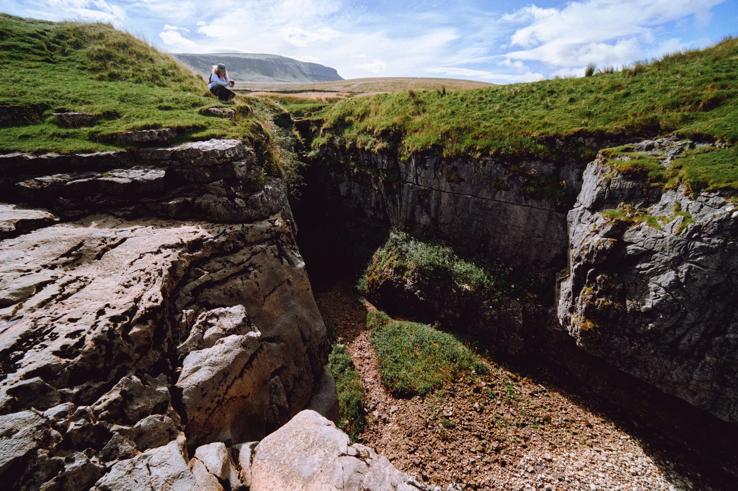
We arrive at Hull Pot. With my 9mm ultra-wide lens equipped, I shot this expansive view of the 60ft chasm from near its eastern edge. From the edge you can actually hear the rushing of a waterfall.
This is Hull Pot Beck. In times gone this river would flow over the lip of Hull Pot, crashing down as a large waterfall. These days it’s mostly dry except during times of heavy rainfall, as the water now sinks underground further up the river.
Lisabet and I played around the edge of the “waterfall” and Hull Pot, finding compositions. In the distance is Pen-y-Ghent, always watching.
Weird to think that this composition would, in ancient times, mean standing at the precipice of a large roaring waterfall.
As we move into late summer, beautiful pink and magenta heather starts to bloom.
My favourite composition in the area: the chasm of Hull Pot with Pen-y-Ghent rising high above.
The 50ft+ sheer walls of Hull Pot. In the darkness there is actually a waterfall that rushes out of the caves at the bottom of this chasm.
After a spot of lunch perched on the lip of Hull Pot’s eastern end, I snap one last photo of the chasm before heading back.
The Pennine Bridleway continues up towards Pen-y-Ghent, the common route to summit the fell.
The atmosphere was wonderfully clear. From above Horton Scar we could see all the way to Pendle Hill in Lancashire, here towards the left of the photo.
The characteristic “rakes” that line the shoulders of Pen-y-Ghent were revealed after a frightful storm in the 19th century washed away a lot of top soil from the fell.
Nearly back at Horton in Ribblesdale. What a beautiful day.
Did you like these photos?
Trollers Gill & Parcevall Hall, Yorkshire Dales, Spring
Happy belated Easter everyone. Did you have a good 'un?
Happy belated Easter everyone. Did you have a good 'un?
Usually for Cumbria, and the Lake District in particular, Easter signals the first tourism wave of the season. With that in mind, and no obligations to serve, Lisabet and I booked a couple of nights away in a beautiful B&B set in bonny Pateley Bridge, in the Nidderdale Area of Outstanding Natural Beauty.
We took the scenic route to Nidderdale from Cumbria, as we didn't need to check in until the evening. So, first we stopped off at the impossibly pretty Yorkshire Dales village of Burnsall for lunch and some light photography. Afterwards we continued east and stopped off near Grimwith Reservoir for the day's main activity: Trollers Gill.
This place has been on my radar, otherwise known as my Pinterest, for years.
It did not disappoint.
All photos shot on my Fujifilm X-T2 using my three prime lenses: a Fujinon 23mm f/2.0, a Laowa 9mm f/2.8, and an adapted Pentax SMC 55mm f/2.0. Images made 80% in-camera using the Astia film simulation, then finished off in Lightroom and Affinity Photo.
Burnsall
After coffee and a bacon butty near the river, we snapped some shots of Burnsall as we made our merry way back to the car. The 5-arched Burnsall Bridge here is a Grade II listed building, originally constructed in the 17th century with some 19th century improvements.
I'm not sure it's possible to get more Yorkshire than this scene. The Red Lion, built in the 16th century, and recently taken over by Thwaites Brewery.
Like many Yorkshire Dales villages, there's plenty of historical sandy limestone buildings decorated with beautiful greenery, flowers, and the distant hills.
Burnsall Primary School. Originally the old Grammar School founded in 1602 by William Craven of Appletreewick, who later became Lord Mayor of London.
Trollers Gill
After Burnsall, I identified a handy little parking area off the B6265 that would serve as the starting point of our hike to, and up, Trollers Gill. The day was bright and sunny whilst also hazy, lending a wonderful sense of intrigue and distance to photographs. Up on the moorland high above Appletreewick, views extended for miles and miles.
The path down the moorland was easy enough to follow, and soon the characteristic karst limestone landscape of the Yorkshire Dales became apparent.
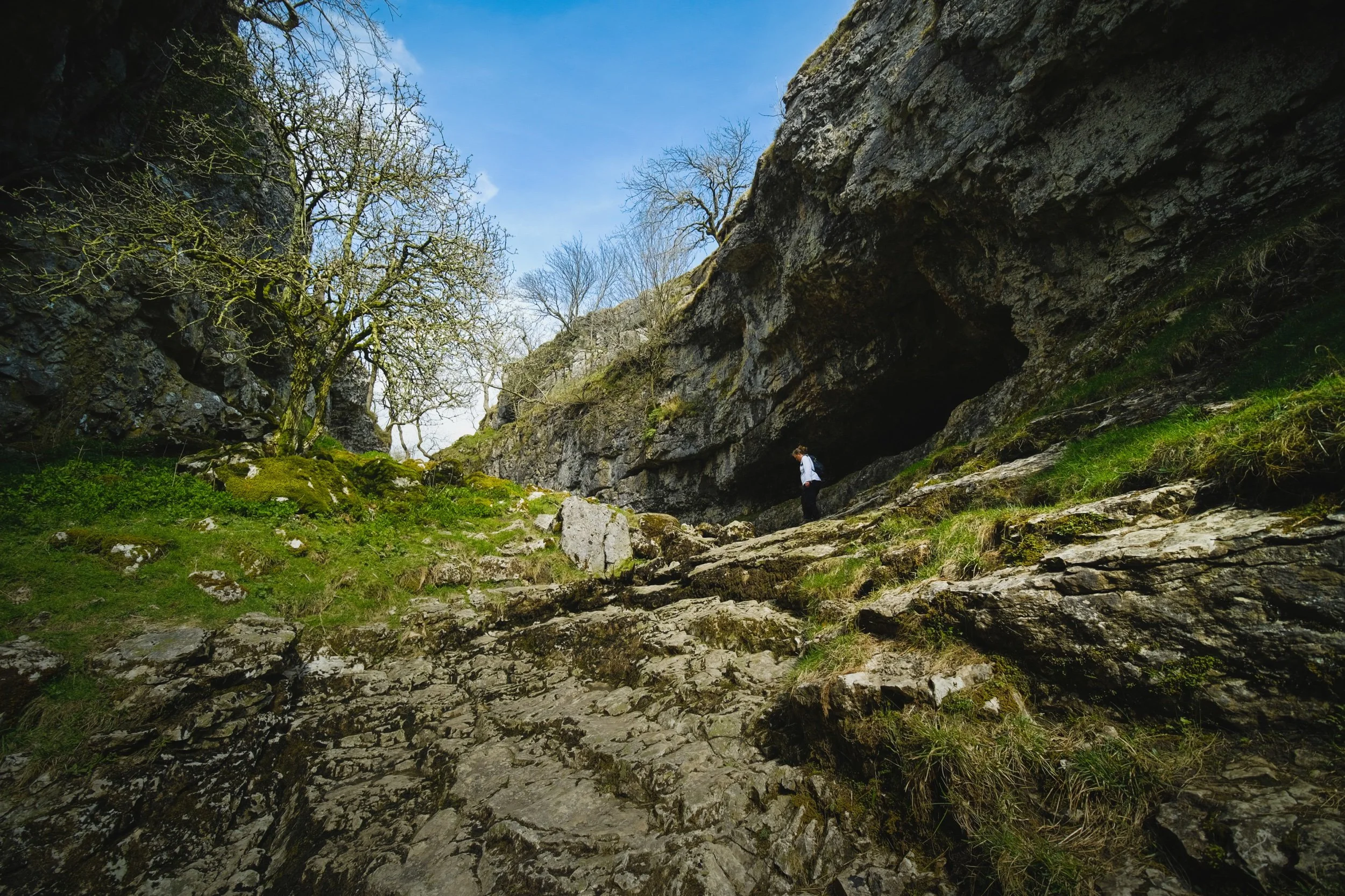
The main signs pointing to Trollers Gill invite walkers to enter the ravine at the top and scramble their way down. Instead, we elected to take the trail around the western side of Middle Fell. This would eventually lead us to the bottom of Trollers Gill.
The anticipation and excitement builds as we near the bottom of the deep ravine.

At the bottom of Trollerdale, we followed the minor path north to start the climb up Trollers Gill. But first, I simply had to snap this glorious scene.
The entrance to Trollers Gill, largely dry for most of the year. Historically this would've been the site of a thunderous ravine with several waterfalls and cascades crashing down the gill. Thousands of years of erosion in a limestone landscape means the beck at the top of the gill now goes underground before entering the ravine, later reemerging at the bottom of Trollerdale.
Looking back at our way into Trollers Gill. Fellow hikers gingerly navigate the way down the ravine. Can you imagine this gorge full of water?
As with many other places in the Yorkshire Dales that features sheer limestone walls, Trollers Gill is a favourite for rock climbers.
Rock climbers assist each other as they ascertain routes up the sheer sides of Trollers Gill.
An ultra wide composition looking up from the bottom of what would've been a powerful waterfall. The meaning of the name "Trollers Gill" comes in two parts. "Gill" is already quite well known and used in Yorkshire and Cumbria, sometimes alternatively spelled as "Ghyll". It means a deep ravine or gully, and is cognate with the word gullet. "Trollers" is split into two: "troll" meaning, well, troll, the mythical beast (not the internet variety), and ears meaning "arse". This gives us "the Troll's arse". You're welcome.
Near the top of Trollers Gill, where the beck mysteriously disappears into the unfathomably twisted caves underneath.
Climbing out the gill and up onto the moorland, we realise that the haze has nearly cleared, giving us a fairly clear shot of Simon's Seat.
The deep drop into Trollers Gill that we had just climbed out of.
The single lane "New Road" that connects with the B6265.
A clear sign that a moorland is particularly and consistently wet: rushes everywhere.
One last look back at the farm track that guided us down into Trollers Gill.
A great discovery! Hanging on a branch near our parking spot was this beautifully preserved sheep's skull, probably a Swaledale. We took it home. Isn't it beautiful?
Parcevall Hall & Gardens
After returning to the car, we realised looking at the map that we were very near Parcevall Hall & Gardens. Fancy a quick visit and a wander? Why not?
Parcevall Hall is a Grade II listed Manor House that includes 24 acres of sculpted and maintained gardens. They were created in 1927 but fell into decline after 1960 following the death of Sir William Milner, 8th Baronet of Nun Appleton. Restoration work commenced in the 1980s.

People can visit and explore the gardens between April and October. It enjoys fabulous views and beautiful displays.
Lisabet and I particularly enjoyed this peaceful statue.
The Gardens, amongst other things, are known for their wonderful view of Trollers Gill, so we followed the route uphill.
Still plenty of daffodils around.
And there it is. Trollers Gill to the right and Middle Fell in the centre, daffodils blooming below. What a fantastic scene.
Cherry Blossom in full bloom at the entrance to the Gardens. What a full and gorgeous day.

Stockdale, Settle, Yorkshire Dales, Spring
Summer has well and truly arrived.
Summer has well and truly arrived.
Following on from our little hike around Stenkrith Park and the Lune Gorge, Sunday greeted with us with clear blue skies and 20+ degree sunshine. That’ll do, nicely.
Endeavouring to stay away from our home county Cumbria and the Lake District, we ventured east towards the bonny Yorkshire Dales town of Settle. We fancied a repeat of 2020’s discovery in this area: Stockdale and the Attermire Scar. Hiking up High Hill Lane towards Scalebar Force from Settle, a common and popular walk, you’d have no idea of the limestone cliffs and crags in the valley to the north.
Branching off from High Hill Lane, a bridleway sign points out Attermire Scar. Following this route takes you into the Stockdale valley, where you can gawp at the incredible caves, cliffs, and limestone crags of Attermire Scar and Warrendale Knotts. Some of the best limestone karst scenery in all of the Yorkshire Dales.
And incredible weather to boot.
All photos shot on my Fujifilm X-T2 using my three prime lenses: a Samyang 35mm f/1.2, a Laowa 9mm f/2.8, and an adapted Pentax SMC 55mm f/2.0. Photos 80% made in-camera using a customised Classic Chrome film simulation, with minor edits later in Lightroom and Affinity Photo.
I don’t think this typographic mural has been on display in Settle all that long. Certainly wasn’t here when we last visited in 2020. Very nice work indeed, and lots of folk were taking pictures of it.
Swaledale ewe and lamb, basking in the day’s warmth up the fellside from High Hill Lane.
A scar in the fellside of High Hill with a remarkable likeness of some sort of prehistoric dinosaur footprint.
As we hike up Stockdale Lane, the views towards the limestone karst landscape start to open up and my excitement levels rise.
This collection of crags and scree is known as Warrendale Knotts, which tops out at 440 m/1,443 ft.
The Holstein Friesians seemed content in the warm fields of Stockdale.
Nearing the top of Stockdale Lane with Attermire Scar and Warrendale Knotts getting ever closer.
After nervously navigating past a field of young bullocks, and getting muddy boots in the process, a turn back for a shot of my lovely Lisabet. She cute.
The way to Attermire Scar and Warrendale Knotts. Already we could pick out fellow hikers below the scars as well as rock climbers high up the crags, testing their skills and might.
The east face of Warrendale Knotts, with some hikers ascending up the channel between this fell and Attermire Scar.
I shot this primarily for the zigzagging lines towards the crags of Attermire Scar.
Another Swaledale ewe and lamb, chilling beneath Warrendale Knotts.
The transitions between scree and grass create a repeating diagonal pattern that my eye enjoys. So I shot the photo.
The western aspect of Warrendale Knotts as it slopes back down towards Settle.
Well… you should know what I’m like with drystone walls by now. See that cave, middle-left? That’s where we rested for lunch.
The view back to Attermire Scar from our lunch spot, and probably my favourite shot from the day.
Again, a series of connecting lines around the photo that gives your eye something to wander around with.
Coming back down from the fells into Upper Settle, with its proper old-school Yorkshire vibe.
Settle is a popular meeting and rest destination for bikers.
Before heading home, we stopped off at the gardens of Settle Victoria Hall for light refreshment, and to give them our support.
A proper English summer fair vibe.