Deepdale, Lake District, Autumn
Grisdale keeps evading us.
Grisedale keeps evading us.
After meticulously scanning the weather forecasts and satellite radars, Dad and I embarked initially on a lovely hike up one of my favourite valleys: Grisedale.
Last time rain fended us off. This time, a running/trials event blocked all the car parks in Patterdale and Glenridding. No matter, that’s why you should have a back up plan! Instead, we drove back towards Brothers Water and pulled up in a little-used layby. This was the start of the hike into Deepdale.
Although no less splendorous compared to Grisedale—featuring as it does the magnificent fell of Greenhow End at its head—it’s certainly not as good to walk. Large patches of Deepdale are often submerged in water and super boggy to boot. This means lots of bog-hopping.
Nevertheless, a crisp yet blowy autumnal day greeted us and Dad and I were treated to delicious light and wonderful colours.
All photos taken on my Fujifilm X-T2 using my three prime lenses: a Fujinon 23mm f/2.0, a Laowa 9mm f/2.8, and an adapted Pentax SMC 55mm f/2.0. Developed in Lightroom using my own Classic Chrome-based preset, finished in Affinity Photo.
An autumnal Arnison Crag (433 m/1,421 ft) above Greenbank Farm. And some actual blue skies!
Closer to the farm, my beloved Herdwick sheep come into view and the sun illuminates the scene.
Passing through the farm, we followed the track towards the valley. As the wind was blowing a hooley, the clouds above passed intermittently across the sun, allowing beautiful spotlighting of light.
As we pass Deepdale Hall, Latterhaw Crag below and the back of St. Sunday Crag (841 m/2,759 ft) come into view, drenched in golden autumnal light.
It’s always important to remember: don’t forget to look behind you. Otherwise I would’ve missed this lovely composition.
Aureate light highlights the boulders that line the cascades of Coldcove Gill.
Rowan berries provide a nice colour contrast against the icy cold waters of Coldcove Gill.
Behind us, the tops of Angletarn Pikes (567 m/1,860 ft) and Place Fell (657 m/2,156 ft) are treated to similarly gorgeous light.
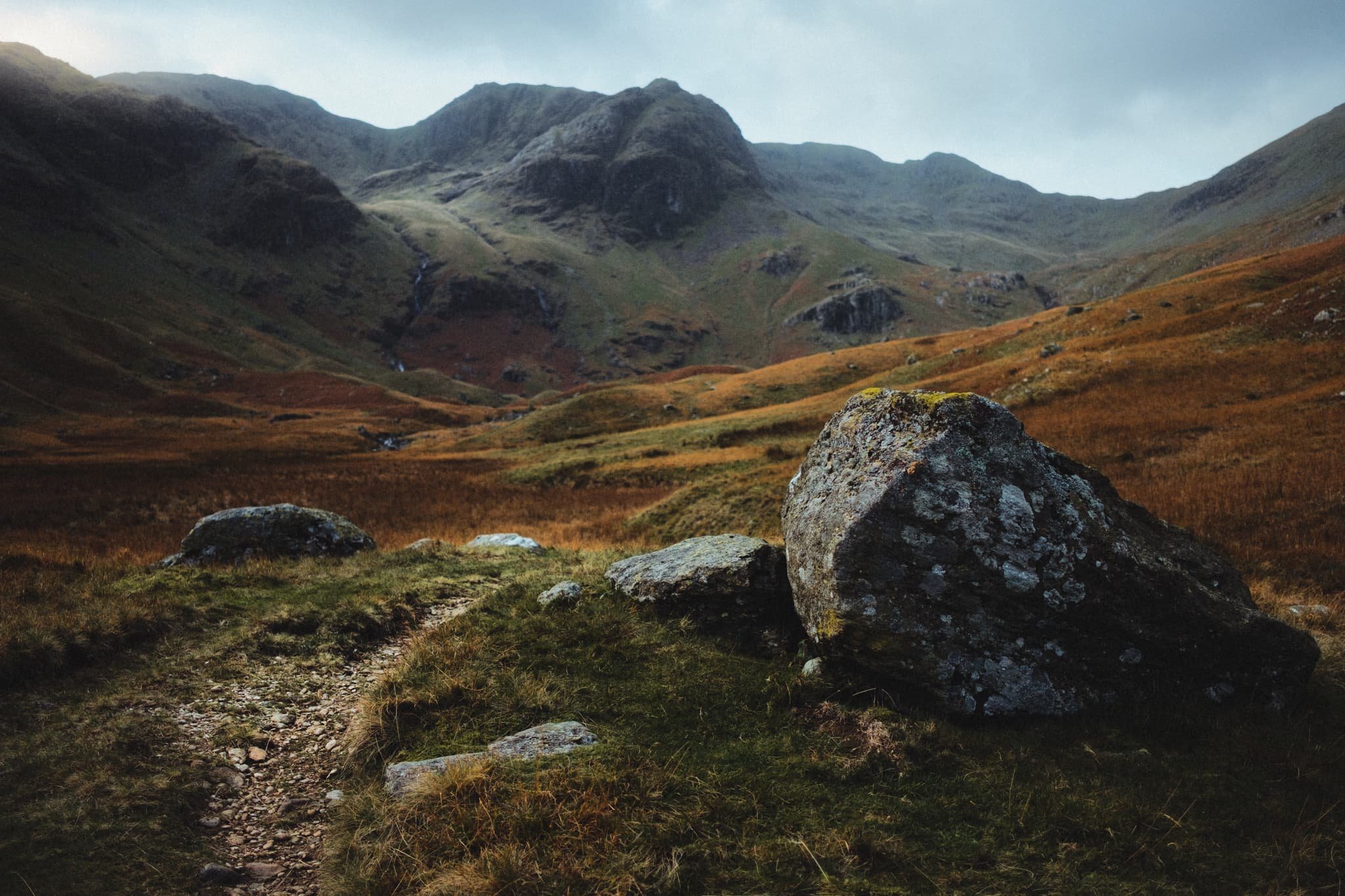
Finally, the crown jewel of Deepdale comes into view: Greenhow End. A magnificent fist of a fell, here being treated to some delicious side lighting.
A clump of boulders blocking the trail provided a lovely scene with Greenhow End in the distance.
We’ve reached that stage of autumn all the bracken and fern turns a beautiful rusty shade.
My Dad, doing what he does best: awkwardly posing (love ya, really).

At various points, the “trail” gets close enough to Deepdale Beck, allowing for compositions such as this.
Dad and I spotted this boulder, and immediately made out the face-like structure in its forms. So, I lined up this composition involving Angletarn Pikes.
Dad, enjoying the light play above us.
I spotted a cluster of boulders and glacial erratics, so I whipped out my ultra-wide lens to nab some more unusual and striking compositions.
I got real close to the glacial erratic, noting its wonderful lines, textures, and colours. I elected for a near-far ultra-wide composition, showcasing the strata in the boulder and Greenhow End above.
One of my favourite compositions from the whole hike. Just a perfect balance of light, contour, simplicity, and colour.
The head of Deepdale gets considerably boggier and impassable. That’s the point I usually turn back. Thankfully the views on the way back are no less splendid.
Place Fell providing the ultimate subject as the farm track makes a lovely leading line.
Sunlight bathes this field in warm light, leaving the fell in relative darkness. A circumstance of light and lines that I couldn’t ignore.
The farm track back to the main road. Almost impossibly idyllic.
Hunger was setting in. Time to grab some lunch.
After he was quite done grimacing at my camera, I managed to snap a nice warm candid photo of me Dad.
A lovely lunch was had at one of the Lake District’s most famous pubs: the Kirkstone Pass Inn, which has been in operation at the top of Kirkstone Pass (454 m/1,489 ft) since 1496 CE. What a lovely day out with Dad.

Aira Force, Lake District, Summer
The weekend has been very wet.
The weekend has been very wet.
The Met Office have stated that, between 10:00am Sunday 28/6/20 and 10:00am Monday 29/6/20, Honister Pass recorded 212.8 mm of rain, “provisionally a new UK June daily rainfall record”.
Honister Pass is in the Lake District. It’s been very wet.
But after some investigations Lisabet and I did spot a gap in the rain towards the Eastern Lake District. So, after work, into the car we went and nipped up and over Kirkstone Pass for an energetic hike around Aira Force.
We were rewarded with a lush gorge and waterfalls absolutely roaring with water.
All photos shot on a Fujifilm X-T2 with a 16–50mm f/3.5–5.6 lens using a customised Velvia film simulation.
Heading up Kirkstone Pass with the cloud shelf just starting to lift off the fells.
And heading down 't’other side of Kirkstone Pass, Place Fell (657 m/2,156 ft) in the distance with Brotherswater underneath it.
Ambitious young ‘uns hiking back up Kirkstone Pass.
The trunk of a Monkey Puzzle tree (Araucaria araucana), looking like wrinkly “skin” that’s sagging with age.
Looking down into the gorge from the bridge above Aira Force. The sheer wall of sounds and flying spray everywhere was immense.
Looking straight down the sheer drop of Aira Force.
Further upstream along Aira Beck you can find some more falls. This is High Force, more of a series of powerful cascades. Still gorgeous, especially in this soft light.
Zooming in on those details of High Force.
Aira Force, in full spate after a weekend of heavy rain. The waterfall is probably one of the Lake District’s most famous, dropping 70ft in two parts with a picturesque packhorse bridge arching above it.
As I’ve written on this blog many times before, the word “force” comes the Old Norse fors meaning “waterfall”. The word “Aira” comes from two Old Norse words: eyrr, which means a gravel bank, and á, which is a river, giving us “river at the gravel bank” and the full name meaning “the waterfall on gravel-bank river”.
We popped out of the Aira Force gorge a little early to go for a quick wander up Gowbarrow Fell. There were some views of Ullswater and its fells that I wanted to show Lisabet. And boy what a view we got.

Brothers Water, Lake District, Spring
Brotherswater is one of those Minimum Effort/Maximum Reward places.
Brotherswater is one of those Minimum Effort/Maximum Reward places.
There’s a small car park and then five minutes walk along the river you reach this expansive view of the Dodds of Patterdale above Brotherswater. It’s quite a wondrous place.
Brotherswater, or Brother’s Water, was the first Lake District site purchased by the National Trust. It was originally called Broad Water but—the story goes—was renamed after the tragic drowning of two local brothers.
All photos shot on my Fujifilm X-T2 with a 16–50mm f/3.5–5.6 lens, using the Classic Chrome film emulation.
The setting sun hits the face of Gray Crag (698 m/2,290 ft), shot from the Cow Bridge near Brotherswater.
The lit summit of Hartsop Dodd (618 m/2,028 ft) reflected in the still water of Goldrill Beck near Brotherswater.
Another shot of a sunset lit Gray Crag almost perfectly reflected in Brotherswater.
My lovely Lisabet capturing pristine reflections of a sunset lit Brock Crags (562 m/1,844 ft), Cat Crag (501 m/1,645 ft), and Angletarn Pikes (567 m/1,860 ft).
Golden light caressing the western face of Hartsop Dodd.
Place Fell catching the last of the light, shot from Kirkstone Pass above.