Morecambe & Heysham, Lancashire, Summer
After a thunderstorm, you need to get those vast and expansive views.
After a thunderstorm, you need to get those vast and expansive views.
On the Saturday, the Met Office issued a Yellow Warning of thunderstorms and torrential downpours. This was very much needed as temperatures were starting to creep up to the mid 20’s again with 90%+ humidity.
If there’s one thing a thunderstorm is really good at it’s clearing the atmosphere. So, on the Sunday, we decided that solid hike along the Morecambe Bay coast, from Morecambe to Heysham and back, was needed. The views across the bay to Cumbria and the Lake District fells are always welcome. Plus, we knew we would have limited time before the next load of thunderstorms arrived.
I decided to equip relatively minimally; just my camera, Sony 28–70 and Vivitar “Series 1” 70–210mm for those super tight and zoomed in compositions.
The views, and the weather, were glorious.
All photos taken on my Sony α7ii using my Sony FE 28–70mm f3.5–5.6 OSS and Vivitar “Series 1” 70–210mm f2.8–4.0 zoom lenses. RAWs developed in Lightroom for iPad using RNI Films’ Portra 160 film emulation, then a little bit of finalisation in Affinity Photo 2 for iPad.
Morecambe & Heysham, Lancashire, Summer by Ian Cylkowski is licensed under CC BY-NC-SA 4.0![]()
![]()
![]()
![]()
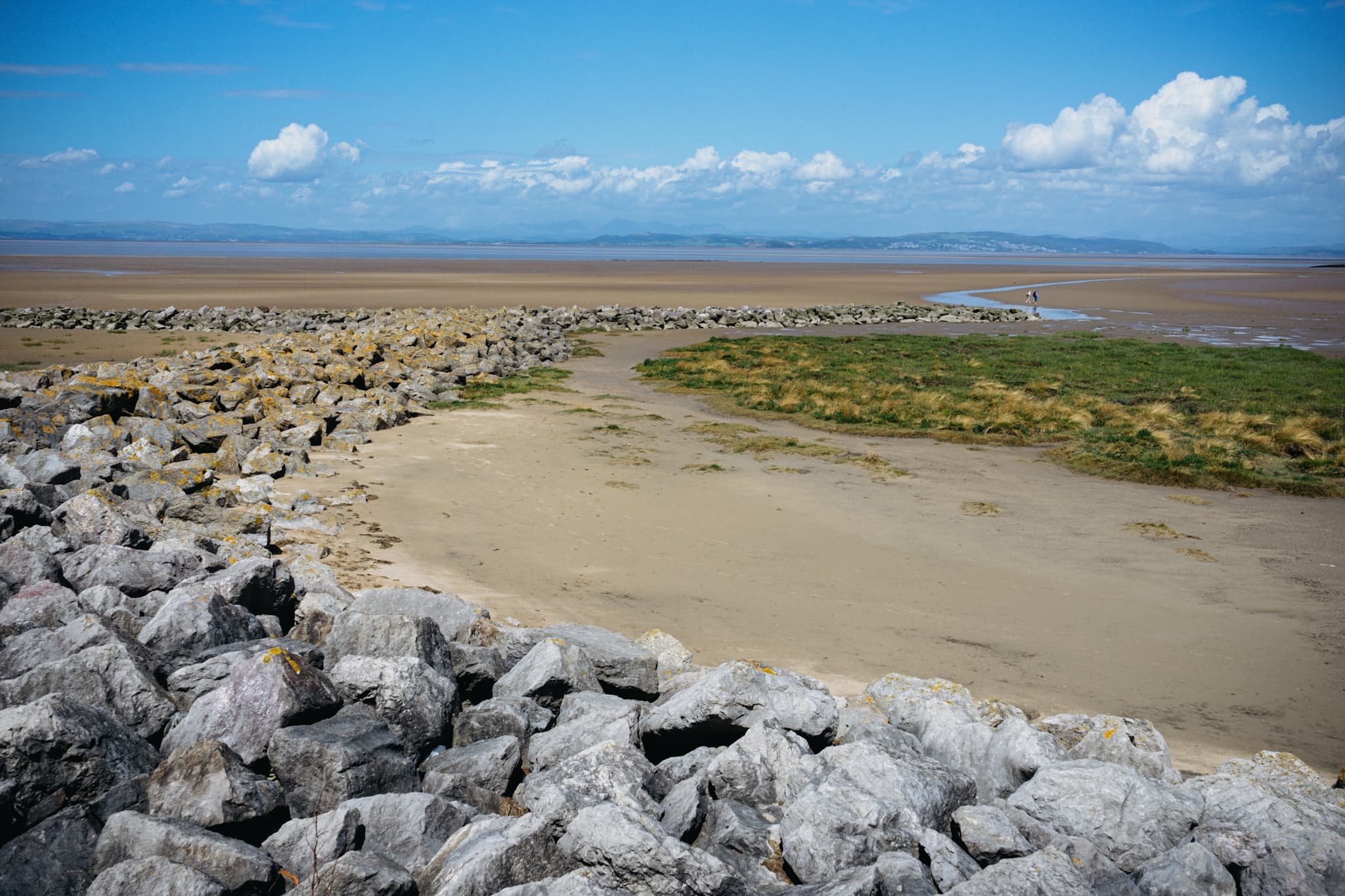
Want sweeping and expansive views for mountains in the distance? Morecambe Bay is where you need to be. Anywhere with access to the Bay will do, but for this walk we chose the town of Morecambe itself.
This is the 14 m tall Hook Beacon, signalling the location of West End Gardens at Morecambe Bay. It was conceived by Broadbent Studio in collaboration with local school pupils.
A man and his dog, watching the world go by.
We started the walk 1-hour after low tide, so the sea was still miles out. Families and couples alike were enjoying the sensation of wet sand on their feet and sea air in their faces.
I decided to equip my 70–210mm lens for some super-zoomed in compositions across the bay to Cumbria.
A lovely mural that I can never resist taking a shot of.
Nice and clear, the Coniston Fells in the Lake District, 25 miles away.
One of numerous breakwaters along Morecambe. This is Grosevenor Breakwater, with Black Combe (600 m/1,970 ft) rising in the distance.
It’s always nice to see people soaking in the vibes of the day and taking in the immense views that Morecambe has to offer.
South beyond the town of Morecambe, ancient Heysham comes into view, resting on a small hill above the Bay.
St. Peter’s church. Christian worship has been regularly practised at the site for over 1,000 years.
The graveyard behind the church enjoys spectacular views across the Bay.
Trees in the graveyard remind us of the passing of time beyond our own horizons.
The ruins of St. Peter’s chapel, dating from around the 8th or 9th century. It gives me vibes of a portal to another world.
A group of six stone-hewn tombs dating from around the 11th century. Each tomb has an associated “socket”, which was probably where a wooden cross would be inserted.
At Half Moon Bay, just before Heysham Nuclear Power Station, one can find the marvellous SHIP sculpture by Anna Gillespie.
The ship's hull is mounted with two opposing figures at each end. One faces "new" Heysham, the Nuclear Power Station, and the other faces "old" Heysham, the ancient monument of St Patrick's Chapel.
The sculpture "celebrates Morecambe Bay's landscape and maritime heritage, and reflects the importance of seaborne trade in bringing news, innovation and shaping the character of the area."
Heading back to Morecambe, I couldn’t resist nabbing the colour contrast of pink and green courtesy of these flowers.
The way back to Morecambe, with plenty of other peeps enjoying the day out in the glorious sunshine.
This gentleman was raising people’s spirits with tunes from his pocket trumpet. He was also kind enough to pose for a photo or two and give us a rendition of “Bring Me Sunshine”, an appropriate tune for the town of Morecambe.
Did you enjoy these photos?
Balquhidder, Loch Lomond & the Trossachs, Autumn, Scotland
Wednesday was looking like another glorious day! So this time we aimed for the more quiet northwestern part of the Loch Lomond & the Trossachs National Park.
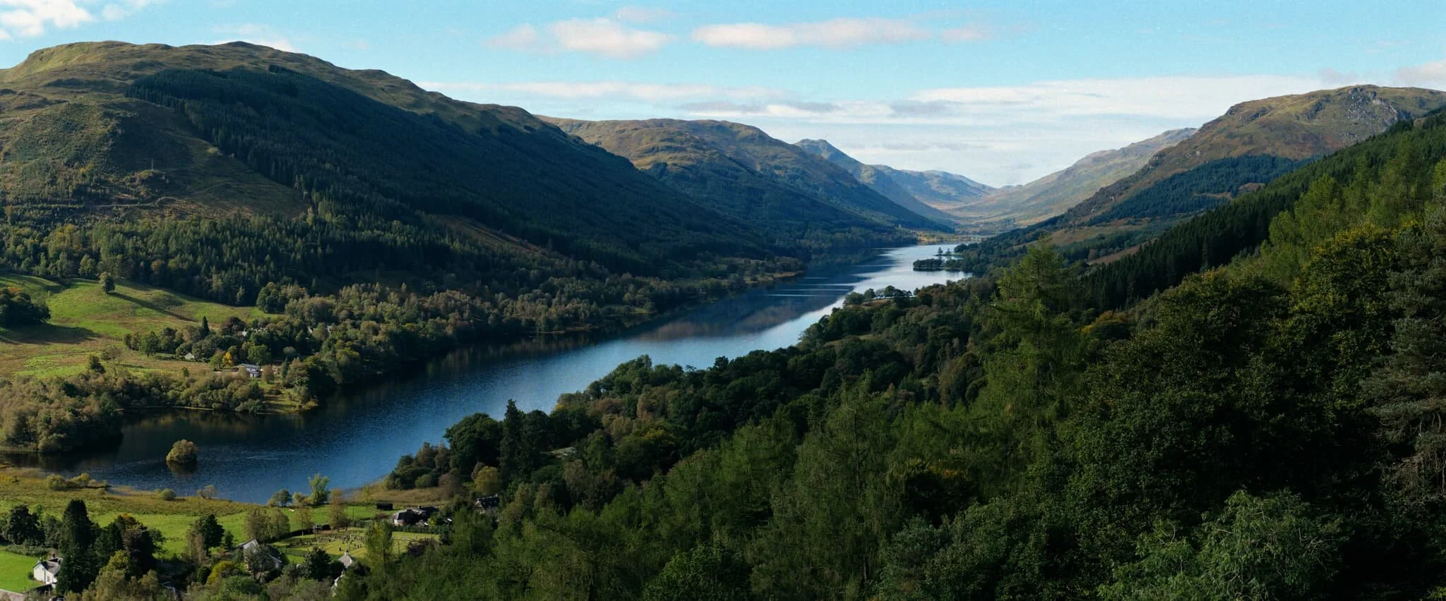
Wednesday was looking like another glorious day! So this time we aimed for the more quiet northwestern part of the Loch Lomond & the Trossachs National Park. Welcome to Balquhidder Glen, lined by mountains known as the Braes of Balquhidder.
Apart from its astounding beauty, the valley is known for being the final resting place of Rob Roy MacGregor, commonly known as Rob Roy. He was an 18th century Scottish patriot, folk hero, and outlaw, sometimes seen as the “Scottish Robin Hood”.
The glen contains two small lochs—Loch Voil and Loch Doine—and is lined with mountains ranging from 600 m or so high to the highest peak above the valley, Beinn Tulaichean at 946 m/3,104 ft high.
We were greeted with a beautifully sunny day, crystal clear reflection in the lochs, and possibly one of the greatest views in the whole of the national park.
All photos shot on my Fujifilm X-T2 using my two prime lenses: a Laowa 9mm f/2.8 and an adapted Pentax 55mm f/2.0 lens. Developed using RNI Films’ Portra 160 film profile.
A short 250 m hike above the village of Balquhidder, one can climb above the Glen Kirkton forest to summit Creag an Tuirc and find one of finest views in all of Scotland. The entirety of the Balquhidder Glen, with its two lochs and many peaks, lays before you. Absolutely stunning.
After carefully clambering back down to the village, we began the walk towards the northern shore of Loch Voil, passing by a variety of beautifully quaint cottages.
In a field near the loch shore, a noisy stallion struts over to us for an inquisitive sniff.
Like much of the Loch Lomond national park, Balquhidder Glen is well-forested and the tree coverage is growing all the time.
After popping out of the woods of Gleann Crotha we were confronted with one of many peaks in the valley. This one is Stob Caol, at 734 m/2,408 ft.
Near the Dhanakosa Buddhist Centre the road winds right close to the loch shore, allowing us access to these incredible views and reflections.
Popping on my ultra-wide lens, I managed to snap this expansive loch view and its glorious reflections.
Further west along the shore of Loch Voil, the view opens up more. We could not have asked for better conditions.
We found a spit of land south of the Buddhist Centre and went wandering into its woodlands for beautiful light and interesting trees.
Howgills, Yorkshire Dales, Summer
It was time to come back to the Howgills.
It was time to come back to the Howgills.
Back in April this year, 2021, Lisabet and I made our first hike up onto the Howgills, summiting Winder (473 m/1,552 ft), the fell that directly overlooks the beautiful Yorkshire Dales town of Sedbergh. It wasn’t hard, during that hike, to gawp at the next fell along the ridge from Winder, namely Arant Haw at 605 m. We vowed to return and tackle Arant Haw.
Today was that day.
The forecast was for clear skies and pushing 20°C, but when we arrived at Sedbergh for around 9am it was relatively chilly and cloudy. As we began our ascent up the Dales High Way up into the Howgills—and the views opened up—it became apparent that the cloud base still hadn’t quite cleared the fell tops. This resulted in amazing light and weather conditions, significantly slowing down our hiking progress (but all for good reason).
After a proper good pull, we managed to summit Arant Haw as well as add on the smaller fell of Crook on the way back down.
What a crackin’ day.
All photos shot on my Fujifilm X-T2 using two of my prime lenses: a Samyang 35mm f/1.2 and a Laowa 9mm f/2.8. Developed with RNI Films’ Kodak Portra 160 profile.
The way marker indicates the Dales High Way, the main trail that takes you up into the Howgills from Sedbergh. The fell on the left is Crook.
This was the kind of light show we were subject to on our way up the Howgills. The cloud base was clinging to the top of the Garsdale and Dent fells, and as the sun was rising they were swirling as they burning off.
Shapely Winder from the Dales High Way. Not our destination for the day.
A fell runner and her anxious dog passed us on their way across Settlebeck Gill and up Crook.
Plenty of lambs and young sheep around the Howgills, warily watching us we disturbed their grazing.
It wasn’t long before we spotted more people heading up the trail behind us. We weren’t in a rush. The light and views were too good to miss.
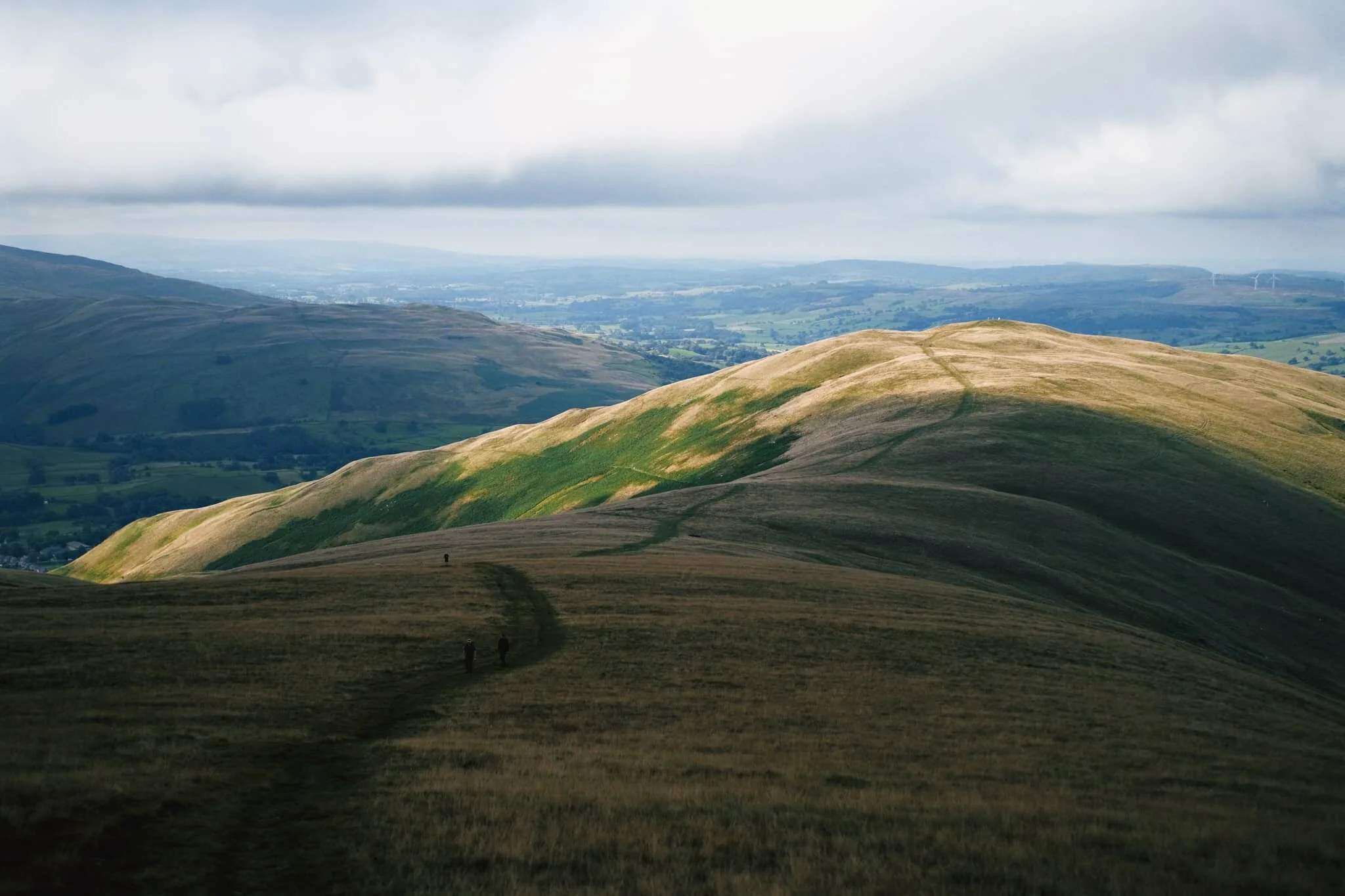
The view looking up Settlebeck Gill. That little hill in the distance with the trail running over it? That’s our destination: Arant Haw.
Looking down Settlebeck Gill, the light and views just get better and better.
The small Frostrow Fells catching the morning light, whilst the Dent fells recede in shadow. Astounding.
The steep folds of Settlebeck Gill, leading down to Sedbergh and the Barbondale fells beyond.
After reaching the plateau above Settlebeck Gill, our destination becomes immediately obvious: Arant Haw.
Looking back to Winder, morning light scanned across the fells and I waited for it to reach the summit of Winder before snapping this composition.
The view north from the summit of Arant Haw. Good heavens.
The views north from Arant Haw take in a succession of Howgills peaks and valleys, felltops such as Calders (674 m/2,211 ft), Bram Rigg Top (672 m/2,205 ft), The Calf (676 m/2,218 ft, highest point of the Howgills), and White Fell (636 m/2,086 ft). The clouds clung to the felltops as the day brightened
Looking down the gill of Swarth Greaves Beck eastwards. Views for miles and miles.
Just astounding.
The western spur that juts out from Arant Haw gives you an indication of the steepness of the fell’s western face.
Zooming in more, I love this arrangement of horizontal and diagonal lines created by the fells and gills.
Time to head down Arant Haw. The conditions looking back to Winder and Sedbergh were starting to brighten up significantly.
The little knobbly fell to the right is our next destination: Crook. There’s not any “official” path to the fell, but that’s no major bother anyway. The Howgills is all Open Access Land.
Swaledale and Rough Fell sheep enjoy the views towards Garsdale as much as we do, it seems.
Even though Crook is only 450 m high or so, the views from its summit are no less impressive.
From Crook it was even possible to make out the back of Wild Boar Fell in Mallerstang, looking northeast.
Looking back up to Arant Haw from around Crook summit, the light getting brighter and brighter.
It was time to come off the Howgills, Lisabet leading the way ahead. We decided on the Soolbank route off Crook, heading down into Settlebeck Gill.
Once we were alongside the banks of Settlebeck Gill, it was simple enough to follow the gill all the down until you could cross and rejoin the Dales High Way back into Sedbergh.
Settlebeck Gill is an impressive sight. The little people hiking the Dales High Way give an indication of scale.
The way back down into Sedbergh, the fells now free of clouds.