Rydal Water, Lake District, Spring
The Lake District is known for many things.
The Lake District is known for many things.
Its lakes, of course. The fells. All the valleys. But also William Wordsworth, who was born in Cockermouth and called the Lake District home for much of his life. It was in the Lake District, wandering along the shores of Ullswater, that Wordsworth took inspiration from the plethora of daffodils along the lake’s shoreline, which ultimately resulted in his most famous poem, “I Wandered Lonely as a Cloud”.
Conscious that the end of daffodil season was approaching, Lisabet and I embarked on a wee circuit around Rydal Water, which I knew to be home to plenty of daffodils. It did not disappoint. Spring is here.
On a separate note, this is also the last set of images taken on my trusty Fujifilm X-T2. With my 40th birthday fast approaching, my Dad did the unthinkable and got me a friggin’ camera for my birthday! A Sony α7ii. Full-frame goodness, here we go.
These photos were taken on my Fujifilm X-T2 using my Vivitar “Series 1” 28–105mm f2.8–3.8 zoom and Laowa 9mm f2.8 prime lenses. RAWs developed in Capture One for iPad, then edited and finalised in Affinity Photo 2 for iPad.
Around Rydal Water there are plenty of areas to choose from when it comes to picking out daffodils for compositions. After one failed attempt behind a bench where I went slip-sliding in the mud, I found this wee clump of yellow beauties and lined up a photo.
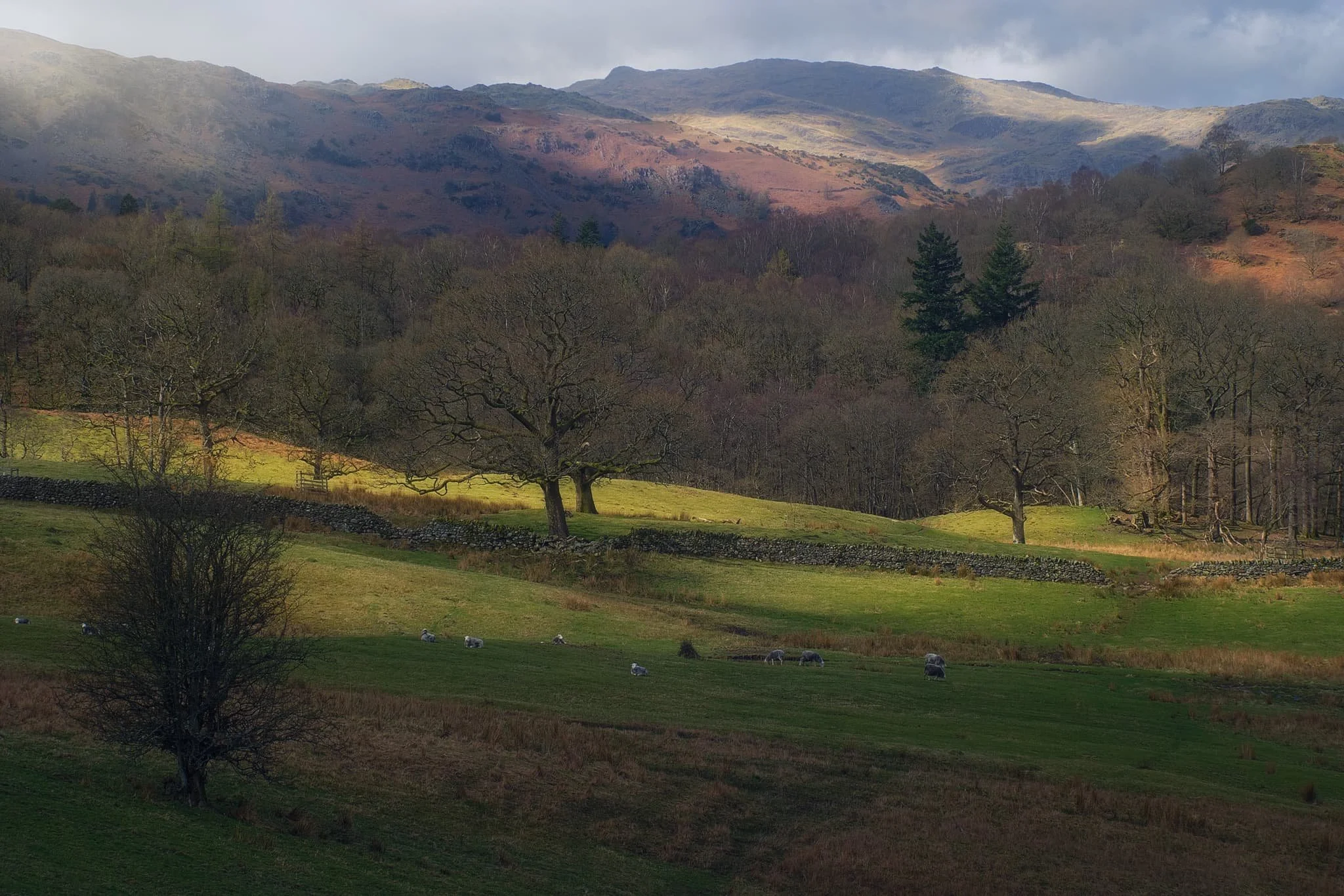
Lovely golden light slithers across the rolling fields and the Grasmere fells above.
Below Loughrigg Terrace, a dilapidated barn provides a nice subject looking back to the Ambleside fells.
Did you enjoy these photos?

Kinlochleven, Lochaber, Scotland, Winter
Where to go on the final day of our week long Scottish Highlands getaway?
Where to go on the final day of our week long Scottish Highlands getaway?
We had a few options, but ultimately settled on an area we’d only visited once, the very first time we explored Glencoe in Autumn 2014: Kinlochleven.
Kinlochleven is a small village situated at the eastern end of Loch Leven and completely surrounded by massive mountains. The Loch Leven valley feels more like a Norwegian fjord; a small ribbon lake with mountains rising sheer from the water.
Last time we visited, we barely scratched the service of what there was to offer, largely because of how unfit I was. That situation is a bit different these days, so we embarked on a more more strenuous and adventurous hike.
It were glorious. A great day to end the week.
All photos taken on my Fujifilm X-T2 using my Vivitar “Series 1” 28–105mm f2.8–3.8 zoom lenses. RAWs converted in Capture One for iPad, developed using RNI Films’ Kodachrome film profiles, finalised in Affinity Photo 2 for iPad.
Kinlochleven, Lochaber, Scotland, Winter by Ian Cylkowski is licensed under CC BY-NC-SA 4.0![]()
![]()
![]()
![]()
One aspect of the Kinlochleven area we completely missed all those years ago was a large and very accessible waterfall. So this was the first thing to tick off the list. This is Grey Mare’s Tail, which plunges nearly 50m in a single drop. This scene, with a tiny Lisabet gazing upon the falls, put me in mind of some of the photographs I’ve seen of some of the Yosemite waterfalls.
After gingerly picking our way around the falls, it was time to begin the steep ascent up the flanks of Leachd na h-Aire to seek views of the loch and the mountains above it. It didn’t take long before we could see the magnificent shape of the Pap of Glencoe above the loch like a wizard’s hat.
Zooming in for a tighter composition of the Pap, using some of these lovely Scottish pines to the frame the scene.
After a slight wrong turn we used this deviation to our advantage by climbing up onto a small knoll that offered this spectacularly clear view of Loch Leven and her mountains. What a sight. The Pap of Glencoe to the left, and Beinn na Caillich on the right.
A small cluster of Scots pines provide a nice compositional aid, pointing upwards to the magnificent Pap of Glencoe. As the day went on, the light got better and better.
Our goal was to locate the now abandoned Mamore Lodge hotel, which has apparently been left to rot for a decade or so now. Along the way, I snapped one more composition of the Pap.
We finally arrived at the former hotel, and scanned around its perimeter. The lodge was originally built in 1903 for Capt. Frank Bibby, who made his fortune in the Liverpool shipping industry. The aluminium works company, whom essentially created the village Kinlochleven, apparently built the lodge in return for the grant of additional land to house workers back down in the village. Sad to see this.
From the abandoned Mamore Lodge, we were able to locate the small road and follow it all the way back down to the loch, happily snapping compositions along the way.
Beinn na Caillich catching some golden wintersun as we followed the winding road down to the loch shore.
Did you enjoy these photos?

Glenfinnan, Lochaber, Scotland, Winter
We were exceptionally fortunate with the Scottish Highland weather.
We were exceptionally fortunate with the Scottish Highland weather.
Although conditions were consistently near the freezing point, we enjoyed days of clear light and skies. The only day that wasn’t the case was when we hiked around Glenfinnan.
Glenfinnan is a place of great natural beauty as well as historical significance. It was here in 1745 that the Jacobite rising began. Prince Charles Edward Stuart (popularly known as “Bonnie Prince Charlie”) raised his standard here on the shores of Loch Shiel in the valley, in the hopes of retaking the British throne for his father, James Francis Edward Stuart.
Glenfinnan is also home to the 792 ft curve of Glenfinnan Viaduct, made famous in recent times for its inclusion in the Harry Potter films where the Hogwarts Express is seen crossing the viaduct in several of the films.
All photos taken on my Fujifilm X-T2 using my Vivitar “Series 1” 28–105mm f2.8–3.8 zoom and Laowa 9mm f2.8 lenses. RAWs converted in Capture One for iPad, developed using RNI Films’ Kodachrome film profiles, and finalised using Affinity Photo 2 for iPad.
Glenfinnan, Lochaber, Scotland, Winter by Ian Cylkowski is licensed under CC BY-NC-SA 4.0![]()
![]()
![]()
![]()
Our goal for the day was to hike the Viaduct Trail. As a circular route, you can start at practically any point. In our case, we began from the picturesque Glenfinnan railway station.
The route leaves the railway station via the woodland beneath it, and starts climbing back up the mountainside towards the viaduct. Here, Beinn an Tuim (810m/2,657ft) was catching a slither of morning winter light.
There are several points along the trail specifically constructed for hikers to enjoy some staggering views. When we arrived, Sgùrr Ghiubhsachain (849m/2,785ft) was being gently bathed in the morning’s rare light show.
Our first glimpse of the magnificent Glenfinnan Viaduct, as it curves its way beneath Mam a’ Chreagain.
We followed the trail down the mountainside for a closer look at the Viaduct. It was constructed between 1897 and 1898 by Sir Robert McAlpine. Built entirely out of concrete, it comprises 21 arches with spans of 49ft and reaches 100ft above the valley.
We came off the main trail to seek alternative viewpoints of the valley and the viaduct. Our reward was this fantastic criss-crossing view all the way up the Glen Finnan valley, with light scanning across the land.
This was the view I was after. The beautiful curve of the viaduct and Loch Shiel’s magnificent mountain backdrop in the distance. This image is made of 5 or 6 vertical shots stitched together to create this panorama.
Down at the shores of Loch Shiel stands the Glenfinnan Monument, erected 70 years after the failed Jacobite Rising of 1745. Atop the monument stands the Unknown Highlander.
Above the loch, the Church of St. Mary & Saint Finnan enjoys a fantastic vantage point of the loch and its mountains.
Did you enjoy these photos?
The Castles of Lllandeilo, South Wales, Autumn
We’re in South Wales for a fortnight!
We’re in South Wales for a fortnight!
It feels great to relax and have a proper break from the severely challenging year we’ve had.
Arriving at our holiday property Friday evening—after a gruelling 5-hour drive in the lashing rain—we woke up Saturday deciding to explore the area nearby where we’re staying around Llandeilo.
Llandeilo is a small town on the western edge of the Brecon Beacons National Park. It’s proper bonny. Evidence of Roman occupation from around 74AD has been discovered here; later on, the settlement was named after a famous Celtic monk—Saint Teilo—with the Welsh word llan meaning a church or monastery, hence the name Llandeilo (pronounced Shan-DAY-loh).
Owing to the long and rich Christian and royal history in the area, there are lots of castles nearby. We explored just two of them: Dinefwr and Castell Carreg Cennen, both impressive in their own right.
After Friday’s insane amount of rain, conditions on the Saturday were thankfully dry and epic.
All photos shot on my Fujifilm X-T2 using my Vivitar “Series 1” 28–105mm f2.8–3.8 zoom and Laowa 9mm f2.8 prime lenses. RAWs converted using Capture One for iPad, developed and finished in Affinity Photo for iPad.
The Castles of Llandeilo, South Wales, Autumn by Ian Cylkowski is licensed under CC BY-NC-SA 4.0![]()
![]()
![]()
![]()
Dinefwr Castle
Below the Dinefwr estate woods, beautiful autumn light and foliage wraps this gorgeous house.
Inside the keep of Dinefwr Castle (pronounced din-EH-vor). The advantage of a 9mm ultra-wide lens is that you’re able to capture a massive field of view in tight compositional situations like this.
Despite being largely built in the 13th century, a lot of the castle is still standing tall and strong.
It’s easy to see why a castle was built here. It’s position on a hill allows for extensive views over the Twyi valley.
It’s possible to climb up the battlements for even more extensive and panoramic views. Autumn colours are just starting to appear in South Wales at the moment.
Up on the highest point of the ruins, looking over the battlements and keep across the Twyi valley on a cloudy and windy day. Truly moody.
The winding stairway leading up is narrow and challenging, especially as the steps themselves are smooth and insubstantial. Amazing how much smaller people were back then.
There’s been a castle at this site since the mid-12th century, but most of present ruins can be attributed to the work of Rhys Gryg in the early 13th century. The castle came into English hands by the end of the 13th century courtesy of King Edward I of England.
By the end of the 15th century the castle came into the hands of Sir Rhys ap Thomas, who began the process of rebuilding and improving the castle. Sir Rhys was a favourite of King Henry VII, largely due to Rhys’ crucial involvement in the Wars of the Roses.
In the distance to the right you can see the turrets of Newton House, built in the 17th century with massive renovations in the 19th century. Around the time of Newton House’s construction, Dinefwr Castle was modified to serve as a summer house.
The castle and its environment were relatively quiet, with most people opting to check out Newton House instead, further to the north. As such, Lisabet and I had ample opportunity to properly explore and photograph the site.
Within the Dinefwr Estate woodland, I spied some gnarly trees covered in moss and quickly sought to make a composition of this gorgeous scene.
The sun appeared from the clouds once again, bathing this house in the woods in autumnal light.
Newton House and its turrets, a wonderful autumnal and historic scene.
Castell Carreg Cennen
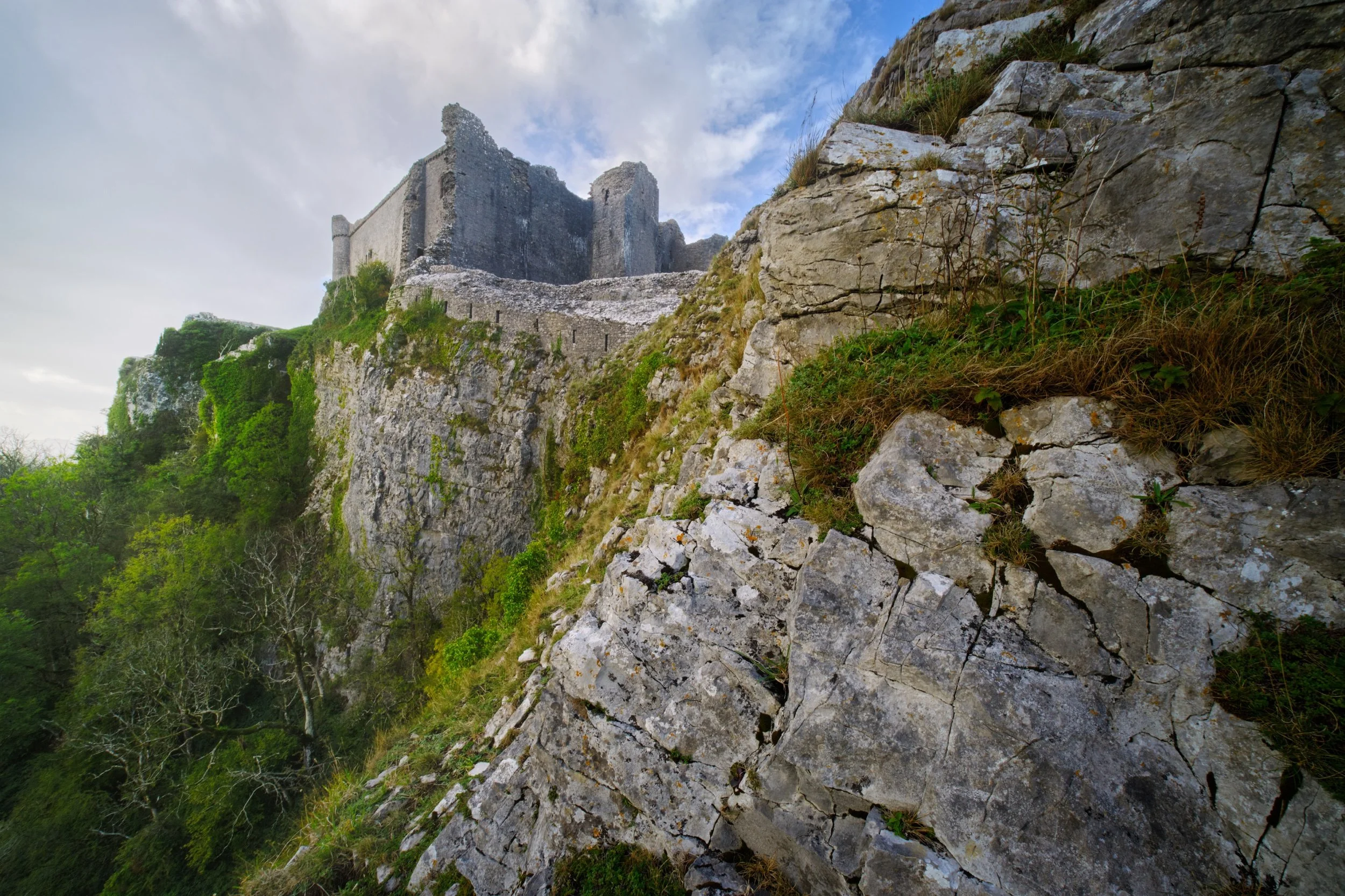
For our second trip for the day, we drove south east of Llandeilo into the Brecon Beacons National Park. Here one can find the impressive ruins of Castle Carreg Cennen, perched atop a high and might limestone crag above the River Cennen.
Rather then head straight into the ruins, Lisabet and I opted to scout around the shoulders of the crag. That’s how we found this ridiculous scene, with the castle perched on the limestone crag and a sheer 300ft drop down.
During our afternoon visit here the weather was much more inconsistent, alternating between brilliant bursts of light and sudden downpours. Whilst I was negotiating my way through the ruins, the sun once again burst through the racing clouds, illuminating this scene.
Castell Carreg Cennen was built in the 12th century, much like Dinefwr Castle, and similarly was claimed by the English through the conquest of King Edward I of England. These days the castle and its land is privately owned by the farm underneath it.
Frankly, one of the most stupendous and visually arresting castles I’ve ever seen.
Back at the farm beneath the castle ruins, a small herd of English Longhorn cows came to graze. Incredible creatures.
A beautiful shaggy coat with those imposing curling horns.
Did you enjoy these photos?

Walltown Crags, Northumberland, Autumn
There’s so much history in the UK that it can sometimes be hard to separate the work of man from nature.
There’s so much in history in the UK that it can sometimes be hard to separate the work of man from nature.
With a beautiful autumnal weekend on the horizon, Lisabet and I set out to meet up with my Dad for a hike somewhere new: Walltown Country Park in Northumberland.
Two things piqued our interest in this place. Firstly, there’s a great section of Hadrian’s Wall to explore here. And secondly, an art sculpture—known as APERTURA—was set up near the wall as part of celebrating 1,900 years since Hadrian’s Wall was built. Isn’t that astounding?
We couldn’t have asked for better conditions. The day was bright, but not harsh; crisp, but not cold; colourful, but not garish. The staff and volunteers at Walltown Country Park couldn’t have been more helpful and friendly, and exploring this section of Hadrian’s Wall and its turrets was absolutely fascinating.
All photos shot on my Fujifilm X-T2 using my Vivitar “Series 1” 28–105mm f2.8–3.8 zoom and Laowa 9mm f2.8 ultra-wide prime lenses. RAWs converted in Capture One for iPad, developed in RNI Films, and finished in Affinity Photo for iPad.
Walltown Crags, Northumberland, Autumn by Ian Cylkowski is licensed under CC BY-NC-SA 4.0![]()
![]()
![]()
![]()
The approach to APERTURA. A striking sight. It’s shape was designed to mimic the geography of the local area, an insight I was keen to demonstrate in this photo.
With my 9mm ultra-wide equipped I was able to capture the entire installation and use the distortion effects of an ultra-wide angle lens to emphasise the shape.
I enjoyed juxtaposing the tip of APERTURA with the afternoon sun, emphasised by setting my lens at f22 to turn the sun into a star.
APERTURA features 1,900 copper chimes of different sizes (to reflect the 1,900 years of Hadrian’s Wall), which all clang together in the wind, creating a fascinating sonic experience akin to church bells ringing.
Another composition presented itself to me, where I was able to frame Walltown Crags underneath the art installation and its imposing stature.
Whilst prowling around the art installation, enjoying its tones and construction, I noticed the moon was bright in the sky. I re-equipped my Vivitar and zoomed in tight to make the installation “point” towards the moon.
From this angle APERTURA almost looks like a spaceship, or perhaps even a B-2 Spirit Stealth Bomber plane.
We rounded back on ourselves, this time taking the longer path towards Walltown Crags, pictured here high above the pond. Walltown Country Park was formerly a quarry until 1976, and has since been allowed to be reclaimed by nature.
APERTURA, in context of the landscape. It is situated on a small ridge where part of Hadrian’s Wall is now missing.
On the path heading up to the top of the crags, Lisabet and I spotted this lovely simple composition of two trees framing a smaller one in the distance. Nothing fancy, but pleasing nonetheless.
Near the top of Walltown Crags the scale of APERTURA and the landscape becomes more apparent.
Made it to Hadrian’s Wall, now 1,900-years old. That mean the wall’s construction began in 122 AD. Crazy.
Emperor Hadrian commanded a wall to be built across Roman Britain, ostensibly to keep “northern barbarians” out. However, it also served as a way of keeping people in Roman Britain, and controlling trade across the border.
The wall ran from Wallsend on the River Tyne in the Northeast of England to Bowness-on-Solway in Northwestern Cumbria, a distance of 80 Roman miles, or 73 modern miles. Large sections of the wall survive, particularly in hillier areas such as here at Walltown Crags and more famously at Housesteads Fort.
The Romans made use of the local geography when constructing the wall. Large sections of it in Northumberland are built on top of various protruding crags made from hard volcanic dolerite rock. This would’ve gave the Romans a panoramic advantage when trying to spot invasions in the distance.
Of course, the local sheep are oblivious to the historical human significance of the area.
The Walltown Crags are volcanic in origin, made from hard dolerite and known as the Whin Sill. It’s exactly the same rock and protrusion you see at High Cup Nick, High Force, Low Force, and Cauldron Spout, and even as far as the Farne Islands in the North Sea. Geology North has a good map of where in North England the Whin Sill has surfaced above ground to create incredible landscapes.
Looking back at our progress across the top of Walltown Crags, tracking the route where sections of Hadrian’s Wall would’ve been. Unfortunately, even in these hillier parts of the wall, sections are missing where they’ve probably been dismantled for building material over the centuries by farmers and/or landowners.
Our destination: two protruding crags where—according to the OS map—one could find the remnants of Turret 44B and Turret 44A.
A pleasing Northern English scene, featuring trees growing from a solitary crag with cows grazing peacefully below.
Looking back at our progress from Turret 44B. It’s theorised that towering turrets were built along the wall every third of a mile, given the wall structure.
My Dad below, taking in the history of the area, as I clamber up the crag to soak in the extensive views.
Honestly, we could’ve happily carried on the trail to see even more of the wall. Alas, parking is expensive and we were due back. Definitely more to check out next time!
Did you like these photos?

Lawson Park, Coniston, Lake District, Autumn
We had opportunity this weekend to visit somewhere a little different.
We had opportunity this weekend to visit somewhere a little different.
As we move from Summer to Autumn—with the increase in stormy downpours apparent—the quality of light improves drastically. But before the legendary Lake District autumnal colours arrive, we’re in peak fruit and berry harvesting season. What better way to observe and learn about growing fruit and vegetables than a tour of Lawson Park above Coniston Water?
A small dwelling has been sited on Lawson Park since the 14th century, when the Cistercian order of monks at Furness Abbey emparked the land here and leased out their building to charcoal burners for use in iron smelting.
The ownership of the building and land has changed hands multiple times over the centuries. By the late 1800s and early 1900s, a succession of tenant farmers lived in the farmhouse, kept livestock and worked the hard uneven land around Lawson Park. The last tenant farmer here vacated the property in the 1950s. England’s Forestry Commission bought the property and house in 1947. Liverpool Community College leased the house from the 1970s for use as outdoor and agricultural educational visits.
By 2000, Grizedale Arts director Adam Sutherland leased the farmhouse with his partner Karen Guthrie. At that time the place was little more than a spartan stone house filled with bunk beds including no central heating. They began the process of renovating the farmhouse and creating the gardens that now lushly surround the area, including the help of Japanese rice farmers in 2007.
It’s a fascinating story and I felt very honoured to have the opportunity to photograph it.
Photos taken on my Fujifilm X-T2 using my Vivitar “Series 1” 28–105mm f2.8–3.8 zoom and Laowa 9mm f2.8 prime lens. RAWs converted with Capture One for iPad, developed in RNI Films, and finished in Affinity Photo for iPad.
Lawson Park, Coniston, Lake District, Autumn by Ian Cylkowski is licensed under CC BY-NC-SA 4.0![]()
![]()
![]()
![]()
Lawson Park has no large-scale parking so we had to park at Brantwood ½ mile away and walk along the narrow East of Lake Road before taking the track up towards Lawson Park. That meant we got to enjoy lovely views of Coniston Water and the Coniston Fells in gorgeous light.
Upon locating the forestry track we climbed higher and higher towards Lawson Park. The views over Coniston Water towards the Coniston Fells, and the Old Man of Coniston (802 m / 2,632 ft) in particular, get better and better.
The light and especially the atmospheric clarity were astonishing. I almost felt I could reach across the lake and touch the fells.
Active coppicing around Lawson Park is still very much evident.
The ferns are beginning to turn colour into their autumnal rust.
Inside Lawson Park house. They’ve done a magnificent job bringing up the building to spec.
Not a bad place to spend a dark evening in.
Above the living room is a study room with books galore. Visitors were free to peruse through what they liked.
Of course, the house enjoys magnificent views towards the Coniston fells.
The flowers around the farmhouse were teeming with pollinators.
Karen Guthrie, Residential Warden of Lawson Park. It’s her learnings and vision that have shaped the gardens and land around Lawson Park into the thriving, sustainable, and environmentally-friendly place it is now.
Her guided tour around the land of Lawson Park and her work managing it was fascinating. This included these boardwalks laid to navigate through some of the bogs, made with local larch.
Karen and the other Grizedale Arts folk were keen to onboard and involve young and precocious artistic talent for various projects around Lawson Park, such as this hut built by art students.
A conifer, Picea alcoquiana, native to Japan and very reminiscent of Japanese bonsai trees.

These hydrangea were humming with insect pollinator activity. Even Karen was surprised.
Lawson Park’s vantage point is sensational, here picturing Yew Pike above Coniston village. To the right, an arts sculpture known as The Err, reminiscent of the Bowderstone above Borrowdale.
A simple larch archway in the farmhouse gardens, which will eventually be covered in creeping vines.
Two young lads make drawings of the view before them.
The Kitchen Gardens complete with polytunnels. Fruit and veg grown here feeds the residents and visitors of Lawson Park and supplies ingredients to nearby Farmer’s Arms in Lowick.
The public footpath back through the woods towards Brantwood, the former home of John Ruskin.
The Yewdale fells catch some of the reappearing late afternoon light as we head back to Brantwood.