Ulverston, Cumbria, Winter
It’s been a while since my last post.
It’s been a while since my last post.
Apologies.
I hope every one has had a nice and/or peaceful Christmas.
Following the arctic blast at the beginning of December, the UK has been wet. Two storms washed over the British Isles—Elin and Fergus—bringing with them intense winds and lots of rain.
Being in Cumbria, we got the bulk of the rain.
Finally, on Boxing Day, clear skies and cool temperatures greeted us. We immediately donned gear and head out to the Furness Peninsula of Cumbria. It was time to hike up the Hoad above Ulverston.
It felt good to finally get out and about.
All photos taken on my Sony α7ii, using my Pentax SMC 28mm F3.5 and Pentax SMC 55mm f2.0 prime lenses, plus my Vivitar “Series 1” 70–210mm f2.8–4.0 zoom lenses. RAW images edited in Lightroom using RNI Films’ Kodachrome film profiles, finalised in Photoshop.
Ulverston, Winter, Cumbria by Ian Cylkowski is licensed under CC BY-NC-SA 4.0![]()
![]()
![]()
![]()
Locating the path from Ford Park, we followed it gently up towards the Hoad. Along the way, this group of trees presented a wonderful framing composition of the Hoad.
The trail quickly grew steeper, which also provided fantastic views. From the shoulder of Hoad Hill, the wet autumn and December are evident in the flooded fields near the coast of the Leven Estuary.
Near the top of the hill, as the trail levelled out, we could start making out the Lakeland fells above the Furness hills. The particularly rounded fell centre-right is Wetherlam (763 m/2,502 ft).
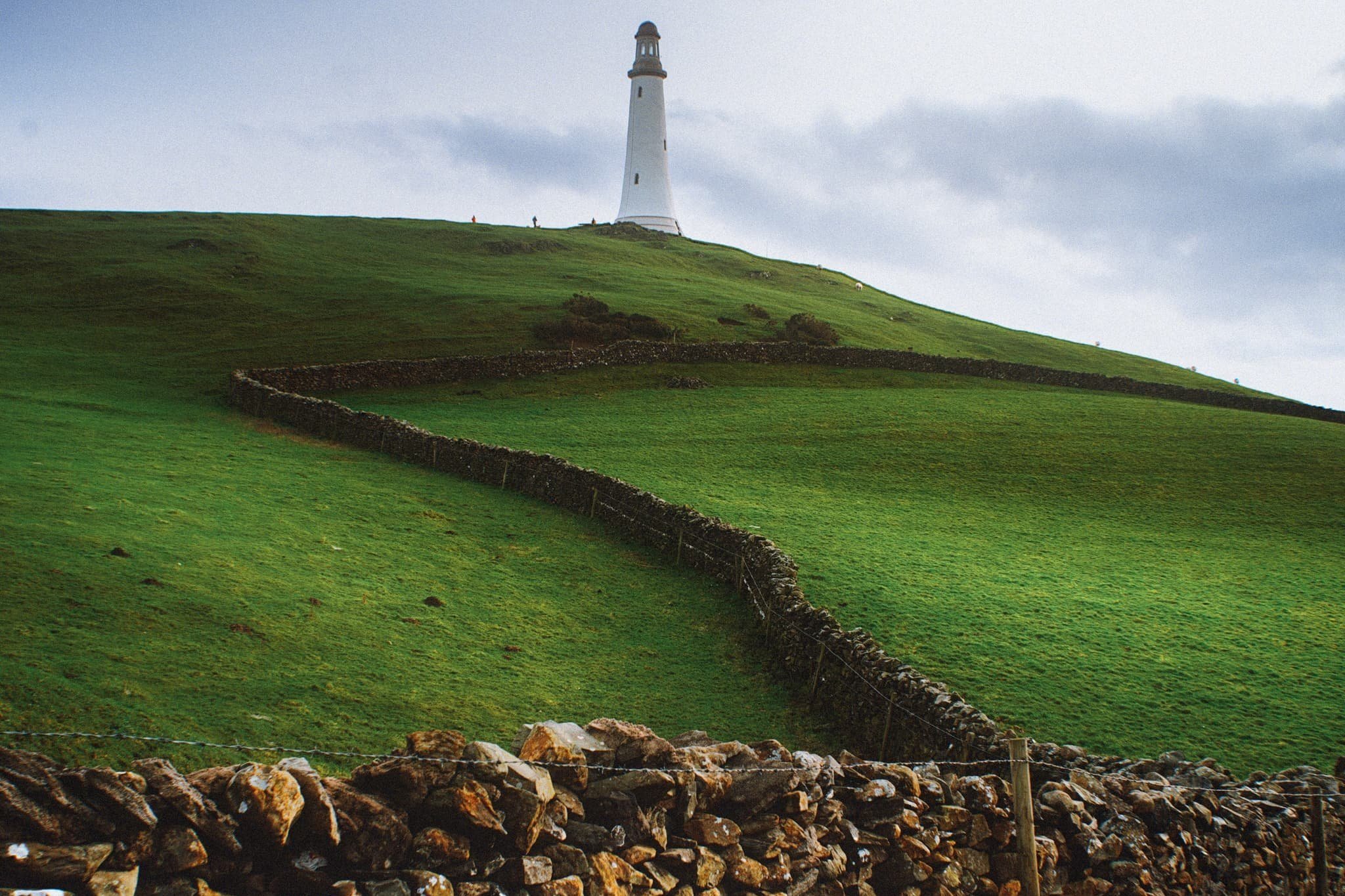
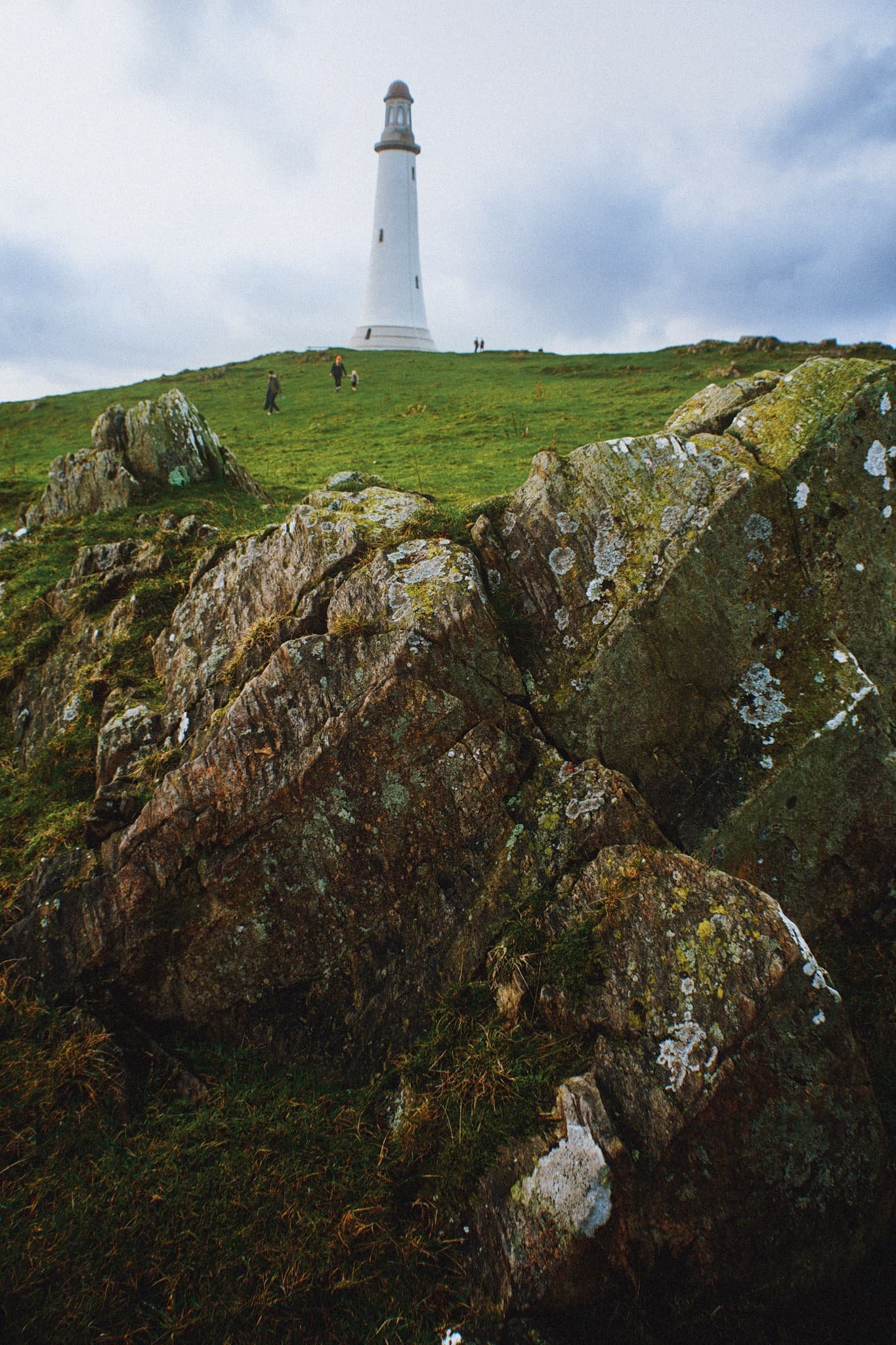
Near the monument, outcrops of Bannisdale Slate gave me a wonderful opportunity for some compositions involving the Hoad.
The Hoad goes by a few names. It’s officially known as the Sir John Barrow Monument, but is also known locally as “the Pepperpot”.
The Hoad was built in 1850 at a cost of £1,250, roughly £138,000 in today’s money. It was built to commemorate Sir John Barrow, who was a founding member of the Royal Geographical Society, and born in Ulverston. Though it looks like a lighthouse, it has never functioned as one.

The views from the Hoad are extensive and panoramic. Plenty of folk were out and about, enjoying a Boxing Day waltz and soaking in the views from the Hoad.
With my 70–210 mm equipped, I was able to pick small sections of Ulverston town. Here, looking southwest from the Hoad, the winding A590 road provides a focal point for the busy architectural landscape of Ulverston.
The view north from the Hoad couldn’t be more different. Rolling countryside, drystone walls, and sheep give way to the mighty Coniston Fells.
Northeast of Hoad Hill, another small hill provides sustenance to yet more sheep. In the distance, the Windermere fells partially obscure the Kentmere fells.
The way back to Ulverston town. You know me, I can’t resist a winding path.
A winding drystone wall catches my eye for a nice composition involving the Hoad.
Back in Ulverston, a wall mural tells the story of Sir John Barrow.
Did you enjoy these photos?
Roudsea Wood & Mosses, Cumbria, Spring
Time for somewhere a little different.
Time for somewhere a little different.
Cumbria being what it is, a sparsely-populated county full of nature, there’s a fair few Nature Reserves never mind the actual Lake District National Park. We’ve explored a few of them previously, for example Foulshaw Moss and Watchtree. This time we ventured south of Windermere and Newby Bridge, beyond the pretty village of Haverthwaite.
This is Roudsea Wood & Mosses Nature Reserve.
The Reserve is located on the eastern side of the Levens Estuary, west of Cartmel. Roudsea Wood is one of Britain’s most important woodland sites, combining varied geology (limestone and slate) with alluvial soils and fens. This has created a woodland full of bio- and geodiversity. Just east of the woods are the bogs of Roudsea Moss, an important area of peat and wildlife, especially Ospreys.
Further west of the Nature Reserve one can hike the Cumbria Coast Way towards the Levens Estuary itself, an extension of the humongous mudflats and sands of Morecambe Bay.
Roudsea: a place of bog, woodland, and sea.
Definitely one for Lisabet and I to keep coming back to.
All photos shot on my Fujifilm X-T2 using my three prime lenses: a Samyang 35mm f/1.2, a Laowa 9mm f/2.8, and an adapted Pentax SMC 55mm f/2.0. Developed using RNI’s Kodachrome film profiles.
Around Roudsea Mosses, the bogs are home to isolated clusters of Scots Pines, making for rather minimalist compositions.
Pleasing to the eye, especially the sense of distance.
The bogs of Roudsea Moss are thankfully easy to navigate courtesy of these boardwalks. They also enable compositions by offering a leading line.
Back into the woods we go.
Delightful tree textures to photograph.
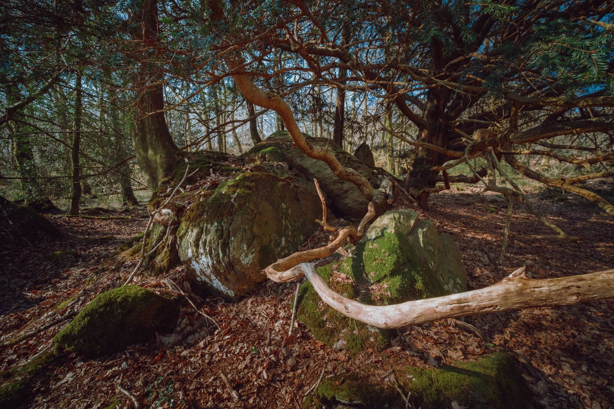
Upon entering the Woodland Trail the geography quickly changes from open bog to a limestone woodland. Lisabet and I spotted this otherworldly scene consisting of tree branches snaking around a limestone outcrop.
There were barely any clouds on our outing, allowing for the sun to penetrate through the canopy of the woodland.
More snake-like tree trunks and branches, with the addition of fungi, which Lisabet was happy to find.
This part of Roudsea Woods was a lot more green, and we were happy to see the beginnings of bluebells appearing on the woodland floor.
Just a moment, when the light caught only this tree.
Flora blossoming everywhere.
An early Bluebell. We’ll be seeing more of these in the various woods around Cumbria within the next fortnight or so.
A weird configuration of a limestone outcrop with a tree root system slowly enveloping it.
Tendrils of wood everywhere, gorgeous textures abound.
After completing the Woodland Trail, we joined the Cumbria Coast Way west towards the Levens Estuary. I knew there would be sand and mudflats ahoy as the estuary is linked to Morecambe Baby, but I had no idea there were these rocky outcrops along the coast.
I was transfixed when I saw these rocks and their beautiful lines, textures, and patterns. I had to come get some compositions in.
We were blessed with a rather beautiful, if hazy, day to be exploring this area of South Cumbria.
Looking back across Levens Estuary towards How Barrow and the Cartmel fells.
An almost impossibly perfect composition that I couldn’t resist on our way back to the car.
Bardsea, Cumbria, Spring
It’s time to say goodbye to our extended Easter break.
It’s time to say goodbye to our extended Easter break.
Not including everyday walks to and from local shops, we’ve managed to clock up nearly 39 miles or 62 km of hiking.
Today was slower. After shopping for food supplies and a quick coffee break, I made and put a ragù on the slow cooker, and then we ventured towards the Furness peninsula for a waltz around Bardsea beach.
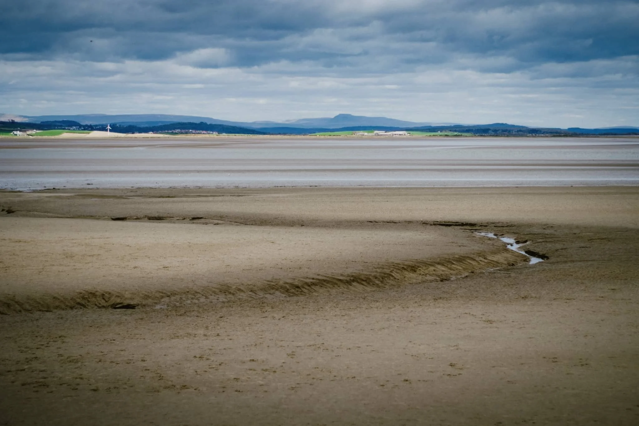
Bardsea beach offers extensive views of the Cartmel peninsula from its position at the outflow of the Levens Estuary, which ultimately joins Morecambe Bay. Much like Morecambe Bay, the coast of Bardsea is largely expansive sand and mudflats with seemingly unending panoramas. On our visit, conditions were clear enough to easily make out the Southern Lake District fells 22 km away and even Ingleborough in the Yorkshire Dales, 43 km away as the crow flies.
Throughout much of its history, Bardsea was a small farming and fishing village, accessible only by carefully crossing the sands of Morecambe Bay. The village also has historical ties with the Quaker movement as founder George Fox married the local landowner Margaret Fell.
Overall, a lovely way to cap off our extended Easter break.
All photos shot on my Fujifilm X-T2 using my three prime lenses: a Samyang 35mm f/1.2, a Laowa 9mm f/2.8, and an adapted Pentax SMC 55mm f/2.0. Developed using RNI’s Fuji Fortia SP film profile.
As a contrast to the consistently clear skies we’ve enjoyed this past week, today was overcast and deliciously moody.
The Southern Fells of the Lake District and the endless expanse of sand at the Levens Estuary.
Even in overcast conditions, you could clearly see Ingleborough (723 m/2,372 ft) from the beach, 43 km away in the Yorkshire Dales.
When the industrialisation of the Furness peninsula developed in the 19th-century, Bardsea became an important sea port. The remnants of all this activity now lies in ruins along the beach front.
I enjoyed the layering of this composition.
A small child, running freely across the sands of Bardsea beach.
When the tide is out, one can follow the many channels cut into the Levens Estuary.
Daffodils and other spring follows bloom in the small woods just off the beach.
Testament to Bardsea’s short-lived but intense period of serving the Furness peninsula as a sea port.