Ynys Llanddwyn, Anglesey, North Wales, Spring
Newborough beach and Ynys Llanddwyn is a magical place.
Newborough beach and Ynys Llanddwyn is a magical place.
Located at the southern corner of Anglesey island (Ynys Môn), Newborough comprises of 2,000 acres of Corsican pine woodland, planted between 1947 and 1965 to stabilise the shifting sand dunes of Newborough Warren. Emerging from the forest, you enter the expansive sands of Newborough beach with crystal clear views across the Menai Strait to the Snowdonia/Yr Eryri mountains.
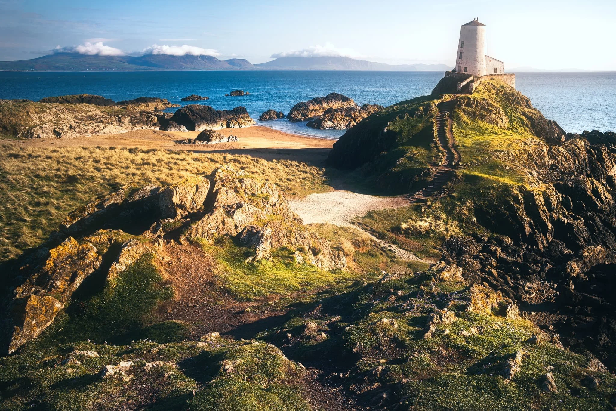
At low tide you can access a small rocky island off the beach, known as Ynys Llanddwyn. The island has historical attachments to St. Dwynwen, the Welsh patron saint of lovers. Ynys Llanddwyn translates to “The island of the church of St. Dwynwen”. It contains the ruins of St Dwynwen’s church, a giant cross on the island’s summit, and the iconic Tŵr Mawr lighthouse.
We couldn’t have picked a more beautiful evening to revisit this ethereal place.
All photos taken on my Sony a7ii using my Vivitar “Series 1” 28–105mm f2.8–3.8 zoom and Rokinon 14mm f2.8 prime lenses. RAWs developed in Lightroom for iPad, edited and finalised in Affinity Photo 2 for iPad.
With the tide out, the already expansive beach at Newborough seemed even bigger. Long channels of pools provided nice compositions involving the mountains of Yr Eryri.
Looking back east along the beach, the sun beautifully lights up the dunes of Newborough Warren, whilst dramatic clouds break up above the mountains of Yr Eryri.
We enjoyed a gentle meander along the beach, slowly but surely heading our way towards Ynys Llanddwyn. Up on the crags, you can see where the tide would separate the island from the beach.
Ynys Llanddwyn is chock-full of rare flora, so it’s generally advised to keep to the dedicated paths, which I made a composition of. In the distance you can just make out the island’s cross and Tŵr Mawr lighthouse.
There are two crosses on Ynys Llanddwyn, this is the Celtic one. Strong side light elevates the scene and highlights some of the Yr Eryri mountains that are crowned with clouds.
A magical moment. Evening golden side light drenches the island and its lighthouse, Tŵr Mawr. In the distance, the Yr Eryri mountains are capped with their own little clouds. A moment I’ll never forget.
Near the smaller tower on the southeastern tip of Ynys Llanddwyn, some volcanic rock formations provide a lovely composition against the endless waters of Caernarfon Bay.
Did you enjoy these photos?

Berwick-upon-Tweed, Northumberland, Summer
Here’s the final collection of work from our week-long summer jaunt around Northumberland.
Here’s the final collection of work from our week-long summer jaunt around Northumberland.
Berwick-upon-Tweed is a town steeped in history and filled with curiosities. It’s England’s northernmost town, right in the northeastern corner of the country. In fact, it’s slightly further north than Copenhagen in Denmark as well as the southern tip of Sweden.
Berwick’s name comes from the Old English berewíc, meaning “corn/barley farm”, which I guess gives you an idea of the town’s origins. During a period of about 400 years, Berwick changed hands between England and Scotland a dozen times or so. Richard of Gloucester retook Berwick for England for the last time in 1482. More than 200 years later, the Kingdom of Scotland joined the Kingdom of England in 1707, forming the Kingdom of Great Britain, and ending the border quarrelling between the nations.
A persistent legend exists about the town “technically” being at war with Russia. The myth goes that because Berwick had changed hands several times, it was regarded as a special, separate entity, sometimes referred to in proclamations as "England, Scotland and the town of Berwick-upon-Tweed".
For the declaration of the Crimean War against Russia in 1853, Queen Victoria supposedly signed the proclamation as "Victoria, Queen of Great Britain, Ireland, Berwick-upon-Tweed and all British Dominions". When the Treaty of Paris was signed to conclude the war, "Berwick-upon-Tweed" was left out. This meant that, supposedly, one of Britain's smallest towns was officially at war with one of the world's largest powers – and the conflict extended by the lack of a peace treaty for over a century.
In reality, Berwick-upon-Tweed was not mentioned in either the declaration of war or the final peace treaty, and Berwick-upon-Tweed was legally part of the United Kingdom for both.
Regardless, the town is fascinating and you can feel the dual-nationality personality of the place. During our wandering, a sea fret obscured most of the coastline, lending a misty foggy atmosphere to our photography.
All photos shot on my Fujifilm X-T2 using my three prime lenses: a Samyang 35mm f/1.2, a Laowa 9mm f/2.8, and an adapted Pentax SMC 55mm f/2.0. Developed using RNI Film’s Astia 100f profile.
The Royal Tweed Bridge as the sea fret rolled in. It was constructed in the 1920s, designed to take on the increasing numbers of traffic away from the old Berwick Bridge, which had stood since the 1600s.
The nice thing about the Royal Tweed Bridge is you can get right underneath it and see its “guts”, so to speak. An incredible piece of engineering.
One of our favourite shops in Berwick, Slightly Foxed. The interior of the shop is almost made out of books, there’s so many.
The weird leaning/curved building is the old Granary, now serving life as the Granary Gallery.
An unusually empty Berwick, as we make our way towards the sea.
As we approach the North Sea, a look back reveals the three bridges of Berwick, which cross the Tweed.
Old riverside properties as the Tweed pours out into the North Sea.
We decide to venture out towards Berwick Lighthouse, England’s most northerly lighthouse. It was built in 1826.
Time to whip out my 9mm ultra-wide lens to capture the entirety of the lighthouse.
And lurking behind the lighthouse, a fisherman investigating opportunities in the North Sea.
We decide to exit the pier and continue up northwards along the Berwick coastline, see what’s what.
Welp, this was an unexpected find. The bloated carcass of a whale, long dead and washed up on the shore of Meadow Haven. I couldn’t tell you what type of whale it was.
Further up the Berwick coastline we came across an unexpected and delightful find: a raised platform of rocks and boulders known as Meadow Haven and Bucket Rocks. Let’s explore compositions!
I’m always fascinated by how geometric geology like this comes to be formed.
We pop up through the dunes away from the sea to find a way through the golf course and back into the town.
A lovely clump of Red Valerian amongst the reeds and sand dunes, Centranthus ruber.
Story time! As we made our way back through Berwick town, we stopped outside someone’s house to admire their front garden filled with flowers. Lisabet took some photos. As she did, an old gentleman enquired approached us to ask about our activity. After learning we were just admiring his garden, he simply invited us through to their back garden, which was even more fecund and filled with all sorts of flowers and vegetables. The “lady of house” was very enthusiastic about her gardening, and was more than happy to meet us and run through the garden with her. I snapped this quick portrait of her. What a wonderfully welcoming and friendly pair they were!
Her garden was, indeed, glorious.
After the Surprise Garden Tour we made our way towards the old town walls and military fortifications that surround Berwick-upon-Tweed. Local kids enjoy a game of footie sent against the 500-year old fortifications.
Walkways have been constructed around the old walls and fortifications, but there are still sections that have been preserved.
This area of the walls are known as the Elizabethan ramparts, which were essentially 16th-century upgrades to the existing 14th-century construction.
And back down the old cobbled street.
Bamburgh, Budle & Cheswick Sands, Northumberland, Summer
Despite being in peak summer, it wasn’t all glorious sunshine during our week in Northumberland.
Despite being in peak summer, it wasn’t all glorious sunshine during our week in Northumberland.
On this particular day I poured over the various weather apps and services I check to ascertain temperatures, chances of rain, atmospheric conditions and more. From what I could see, if we stayed near the coast of Northumberland around Bamburgh we could probably avoid a lot of storms that were moving southwards.
After a beautiful morning of sunshine wandering around the beaches of Bamburgh and Budle, another glance at the weather services indicated a storm moving in over the area. This was also self-evident as the clouds above the beach and castle of Bamburgh were getting dark and foreboding. Lisabet and I nipped into a pub for lunch and decided on another beach further north that we hadn’t explored before: Cheswick Sands.
Thankfully, this was the correct decision. Not only did the rain fall as soon as we arrived at the pub (thank you, Lord Crewe Hotel), but the conditions at Cheswick Sands were blessedly dry. More than that, Cheswick Sands is beautiful. The area features extensive dunes, soft beaches, and fantastical sandstone formations to play around with photographically.
I made perhaps some of the finest seascape compositions I’ve ever done.
All photos shot on my Fujifilm X-T2 using my three prime lenses: a Samyang 35mm f/1.2, a Laowa 9mm f/2.8, and an adapted Pentax SMC 55mm f/2.0. All images were made 80% in-camera using a customised Velvia film simulation, with minor edits and corrections after in Lightroom and Affinity Photo.
An early start meant we were able to park freely in Bamburgh and wander around the village with few people around. Pretty much no matter where you are in Bamburgh, the castle is sure to dominate the skyline.
The grounds around Bamburgh Castle were looking particularly lush and verdant.
Not something I expected, or wanted, to see when clambering around Harkess Rocks on Bamburgh beach. A dead Northern Gannet (Morus bassanus). You tend to see these beautiful birds more around cliffs and isolated rocky islands, so I’m not sure why this one was found near the beach.
My first aim of the morning at Bamburgh beach was to head to Harkess Rocks, which separates Bamburgh beach from Budle Bay. Here one can find a painted deer. Is it prehistoric? A recent piece of art? No-one’s quite sure. One story says that it was painted because a white stag jumped into the sea to escape hunters. Another story reckons it was painted by Italian prisoners of war during World War 2.
Harkess Rocks and Blackrock Point features a prehistoric fault line and a confusing jumbled mass of ancient volcanic rock. Compositionally, I think this area is better to shoot when the tide is in, allowing the water to better separate the shapes of the rocks.
Above Harkess Rocks is Bamburgh Moor, where Lisabet alerted me to a field full of these beautiful flowers (Phacelia tanacetifolia or Purple Tansy). You can read about the farmers who manage this field and why they sow the flowers here.
You’ve gotta admit, it’s a pretty stunning scene.
More of the layering of the scene is involved in this composition as the day started to brighten up.
North of Bamburgh Lighthouse, around Blackrocks Point, we found this open rock pool surrounded by these tessellating structures of volcanic rock. Made for a lovely, if challenging, composition.
Back from the main rock pool, I spotted another smaller rock pool filled with vivid lime green sea moss. I lined up a composition to create a kind of Figure-of-8 shape in the middle of the frame, surrounded by the dark volcanic rocks of Blackrocks Point.
North west of Blackrocks Point and Bamburgh beach, the sands open out into Budle Bay and its vast expanse of golden sand.
One reason on this day not to venture into the sea for a paddle or a swim: jellyfish. No thanks.
A minimalistic composition involving the vast virgin sands of Budle Bay.
Heading back south towards Bamburgh, the day brightened up and people had arrived to soak up the sun. In the distance, you can make out one of the Farne Islands, an important wildlife habitat.
The hulking might of Bamburgh Castle, standing protectively over the coastline and sea.
At around midday the beach was quickly filling up with people. I nabbed this quick composition of Bamburgh Castle in the distance with the edge of Harkess Rocks closer to the viewer.
This was where we decided to exit the beach and devise an alternative plan to avoid the approaching storm. Foreboding indeed.
The approaching storm made for some dramatic clouds above Bamburgh Castle, though.
Seemingly oblivious to the approaching storm about to drench them in rain, a group of friends enjoy a game of croquet in the fields next to Bamburgh Castle.
Bamburgh’s a proper bonny village.
After escaping the rains falling over Bamburgh and inland Northumberland, we drove north to visit a relatively little-known beach called Cheswick Sands. I snapped the rather dramatic skyline from the car park. Good job we weren’t under that.
Access to Cheswick Sands involves clambering up and down the soft sands of Cheswick’s dunes. From the top of one, I made this composition of the undulating dunes, the North Sea, and the dark storm in the distance.
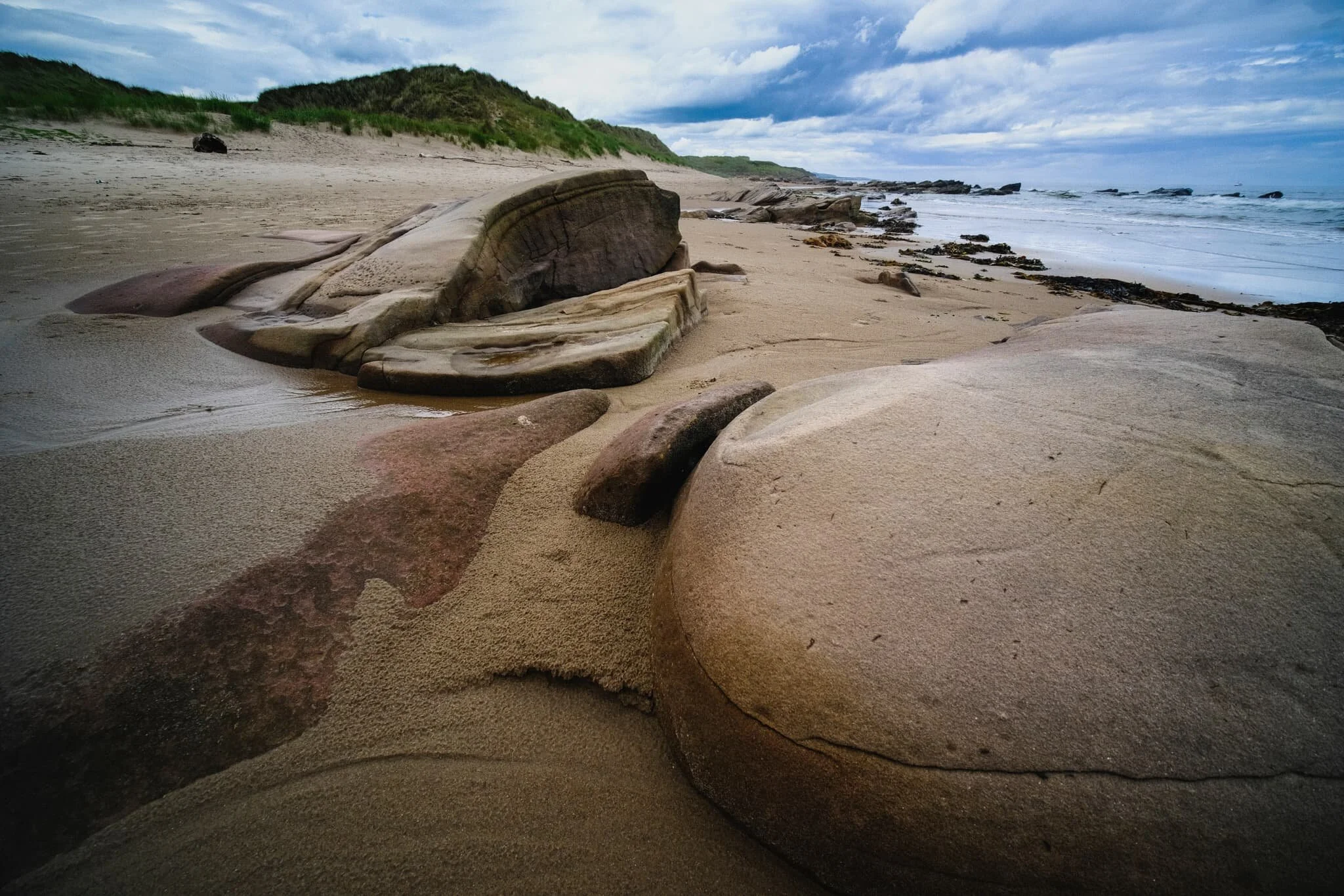
As we gently wandered north along the gloriously empty beach of Cheswick Sands, we came across a band of exposed sandstone known as Cheswick Black Rocks.
They featured some wonderfully sculptured and bizarre rock formations, shaped over the eons by wind and sea. I had lots of fun making compositions of them.
It’s not very often I get to keep my ultra-wide 9mm lens on and play around with strange rock shapes and near-far photographic compositions. Loads of fun!
Probably my favourite composition of the whole day.
The northernmost parts of Cheswick Black Rocks were still covered in slippery seaweed and moss, which made for great colours.
Sculpted rocks, sand dunes, the North Sea, and a stormy sky. Love it.
I managed to climb on top of some of the higher rocks to grab this more unusual curving shape, accentuated courtesy of my 9mm lens.
Another fantastical rock formation, seemingly made of “scales” of discs folding over each other.
Curving flowing lines and pure untouched sand with a dramatic sky above.
As the sun came out to play a bit more, I found this beautiful boulder that I had to make a composition of before we returned to the car.
Miles of rippled wet sand and a long pool reflecting the dramatic sky above. What a quality day.

Retro Reworking: Mull of Galloway, Scotland, Winter 2018
Welcome to Retro Reworking, otherwise known as “the country’s on lockdown due to a global pandemic so I have a lot more time on my hands also I’m better at editing nowadays”.
Killantringan Lighthouse, north of Portpatrick. Its name comes from the Scottish Gaelic Cill shaint Ringain, meaning “St. Ringan's chapel”. The lighthouse came into life at the start of the 20th century, and was automated in 1988.
Welcome to Retro Reworking, otherwise known as “the country’s on lockdown due to a global pandemic so I have a lot more time on my hands also I’m better at editing nowadays”.
Back in the tail end of winter 2018 Lisabet and I took a short break to the Rhins of Galloway. This is a long north-south peninsula that ends in the south at the Mull of Galloway, the southernmost tip of Scotland. We’d never been here before; our closest venture would’ve been Galloway Forest Park, 30-odd miles east inland.
Despite hiking in winter we were treated to clear blue skies and endless views. We spent most of our time scanning the western coast of the peninsula, ducking in and out of various bays, and hiking along the tops of cliffs. The Mull of Galloway, in particular, provided epic views from its cliffs.
All photographs shot with my camera at the time, which was a Sigma dp0 Quattro with a built-in 14mm f/4.0 lens. ND grads and polarisers were used in-field to balance exposures. Editing and colour grading done manually myself.
Port Mora, one of the numerous little bays one can explore when hiking north from Portpatrick towards Killantringan Bay.
The sweeping views towards the sheer cliffs of the Mull of Galloway. I primarily shot this photograph because I liked the way the ripples in the grass served as repeating leading lines towards the cliffs. Yes, it was bloody windy.
The sheer cliffs of the Mull of Galloway. This was shot from the top of Lythe Mead towards McTaggart’s Rock. I recall seeing a fox corpse further down the cliff here; probably lost a chase against the resident sheep population.
Getting amongst the craggy rocks and sea stacks of Port Logan Bay, looking towards the Mull of Logan.
The Island of Colourful Rocks
Ynys Llanddwyn, the spit of craggy land off Newborough beach in Anglesey, is a botanist’s dream. Not only is the island covered in all sorts of wild flowers, but the exposed crags are drenched in a variety of lichen and moss that create these wonderful tapestries of colour.
Lisabet and I clambered down from the main headland of the island to get a closer look at some of the fascinating colours and plant life on these crags. I shot this composition of one particular crag, looking towards Tŵr Mawr lighthouse and the ruins St Dwynwen’s Church.
Camera: Sigma dp0 Quattro
Lens: built-in 14mm f/4.0
ISO: 100
Aperture: f/16
Shutter speed: 1⁄100s
Software: Sigma Photo Pro, Nik Collection, Affinity Photo