
Feizor, Yorkshire Dales, Spring
I don’t explore the Yorkshire Dales enough.
I don’t explore the Yorkshire Dales enough.
After finally getting over my post-Skye mourning and depression period, it seemed like spring finally arrived in Northern England.
Aware of how busy the Lake District would be, we instead ventured east to the Yorkshire Dales. We quickly realised that we hadn’t explored the Feizor area of the Dales in a long time, like maybe 7-years or so. Time to fix that.
Feizor (pronounced “FAY-zer”) is a tiny l’al hamlet between Austwick and Settle, and easy to miss. Home to a few houses, a farm, and the famous Elaine’s Tearoom, rising high above the hamlet are the limestone fells of Pott Scar and Smearsett Scar. These were the focus of the day’s hike and exploration.
Pott Scar and Smearsett Scar were beautiful examples of limestone karst landscapes, but they also offered immense views to either the back of Ingleborough or the shapely Pen-y-ghent.
A super day.
All photos taken on my Sony α7ii using my Sony FE 28–70mm f3.5–5.6 OSS and Vivitar “Series 1” 70–210mm f2.8–4.0 zoom lenses. RAWs developed in Lightroom, then tweaked and finalised in Photoshop.
Feizor, Yorkshire Dales, Spring by Ian Cylkowski is licensed under CC BY-NC-SA 4.0![]()
![]()
![]()
![]()
A near-timeless scene in the heart of Feizor. Old stone buildings, dry stone walls, foliage everywhere, and the fells rising up behind.
This quaint scene, complete with old water pump, was something I couldn’t resist making a composition of.
Round the back of Pott Scar, before ascending, one can enjoy expansive views towards Pen-y-ghent, one of the Three Peaks of the Yorkshire Dales.
The squelchy slog up the fell was rewarded with beautiful views from Pott Scar towards Smearsett Scar.
Fin-like clints and grikes of limestone made for a nice leading line towards Smearsett Scar.
Nearer the edge of Pott Scar, I focus stacked these bare limestone edges as they curved off into the distance towards Smearsett Scar.
From the summit of Smearsett Scar, the full extent and shape of Pott Scar is revealed. The day was brightening up too, albeit with a haze.
The summit of Smearsett Scar offers a bounty of limestone clints and grikes that I want to make compositions of.
Another variation from the summit of Smearsett Scar, using the exposed clints and grikes as a leading line towards Pott Scar.
Back down the back of Pott Scar, drafting clouds cast dancing shadows across Moughton Scar and the back of mighty Ingleborough, another one of the Three Peaks of the Yorkshire Dales.
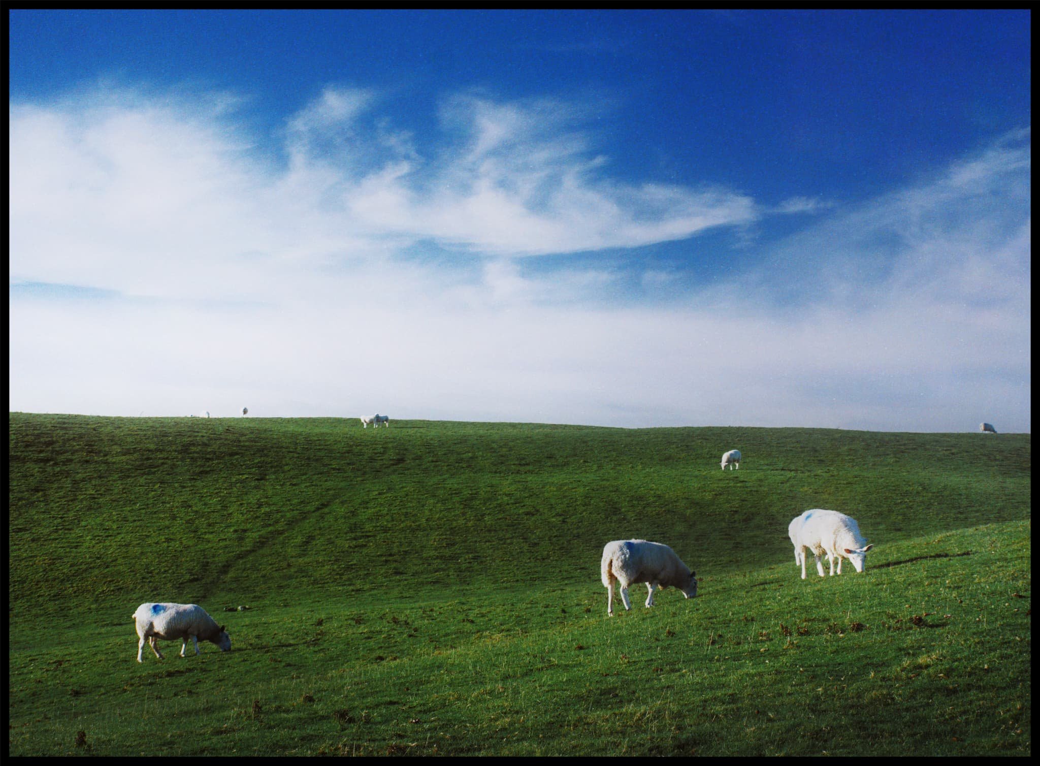
Plenty of teeny Swaledale lambs about, hastily retreating back to their mums as we followed the track back to Feizor.
The single road that winds its way through Feizor.
A super-zoomed in composition of the back of Ingleborough, taken from the small lane between Feizor and Buck Haw Brow, light dancing across the karst features of the land.
Did you enjoy these photos?
Dovedale, Peak District, Autumn
From the Dark Peak to the White.
From the Dark Peak to the White.
In my last post, I talked about how the Peak District can be broadly split into two areas: the Dark Peak and White Peak. They reflect the predominant underlying geology: gritstone for the Dark Peak, and limestone for the White Peak.
After exploring the Dark Peak’s Froggatt and Curbar Edges, it was time to navigate the deep valley of Dovedale in the White Peak.
Dovedale is a particularly famous area in the Peak District—and the UK in general—seeing around 1 million tourists a year. It features stepping stones, rocky spires, craggy hills, and caves.
We elected to hike the full route, south to north, from the main car park to Milldale and back. In my view, Dovedale exceeded spectations.
All photos shot on my Sony α7ii using my Sony FE 28–70mm f3.5–5.6 OSS zoom and Rokinon 14mm f2.8 ED AS IF UMC prime lenses. RAWs were developed and edited in Lightroom for iPad, and finalised with the help of Darkroom for iPad.
Dovedale, Peak District, Autumn by Ian Cylkowski is licensed under CC BY-NC-SA 4.0![]()
![]()
![]()
![]()
Upon entering the valley, it became immediately apparent how steep and craggy the valley sides were.
Arguably Dovedale’s most recognisable landmark, the stepping stones. Used to cross the River Dove and continue up the valley. This photo was unfortunately timed. I waited for this composition, looking for someone to cross the river to provide context for the photo. Instead, I managed to snap the moment just before this poor gentleman fell into the river. He wasn’t hurt, thankfully, and was quickly helped out.
Further into Dovedale and glorious autumn colours revealed their hues in the woods of the valley.
The first tastes of what was to come. This limestone spire is part of the Tissington Spires that line the eastern side of the valley past Lover’s Leap.
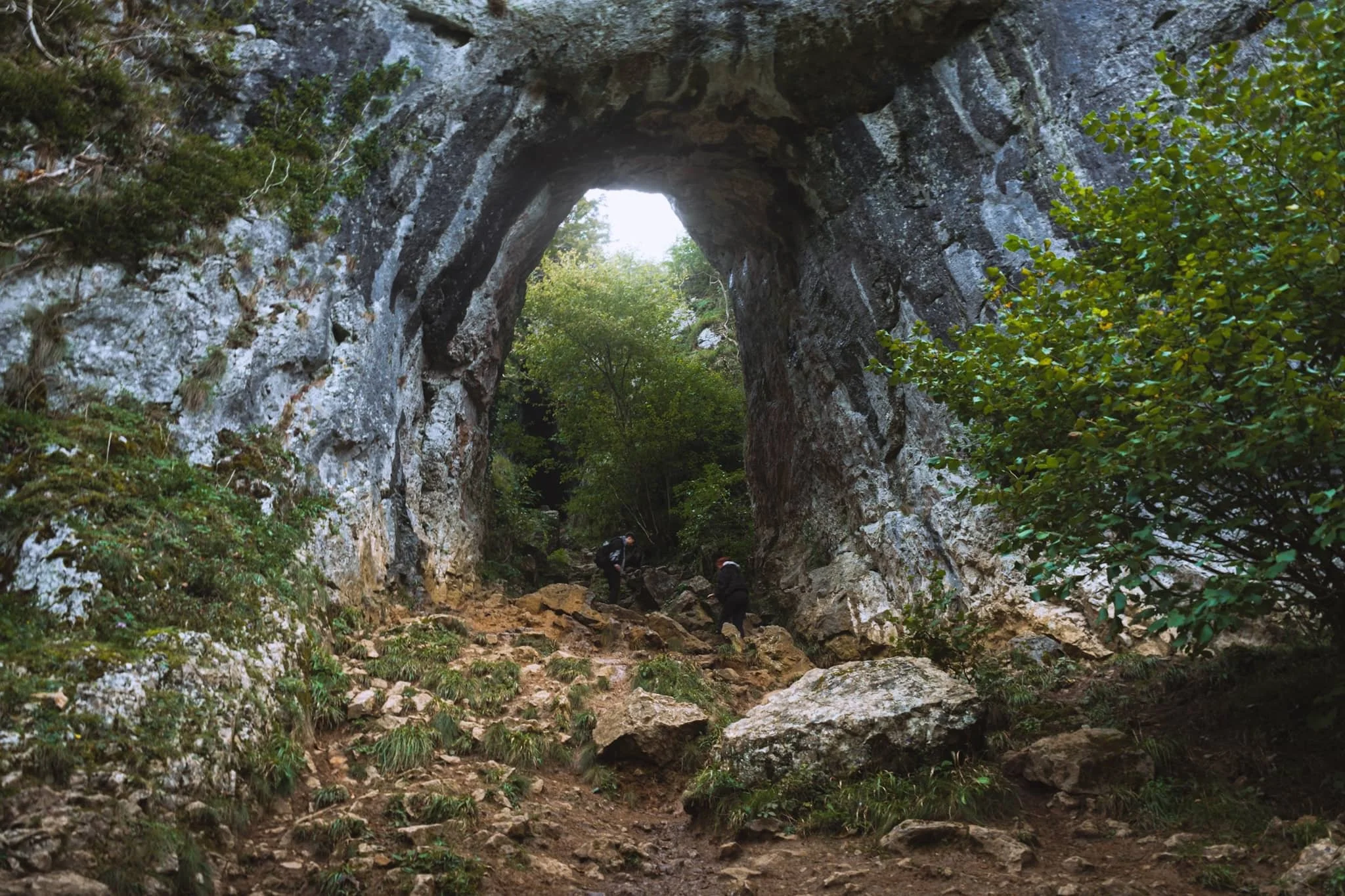
We paid particular attention to finding this spot, and were not disappointed. Beyond Tissington Spires an inconspicuous trail branches off the main valley footpath. It climbs up the steep valley side, revealing this monumental scene: a limestone archway, beyond which is Reynard’s Cave. A stupendous scene.
Beyond Raynard’s Cave, Dovedale narrows and deepens further into an area known as the Straits. Passage is possible only via a raised boarded trail. Once off the boards, we noticed a small cave with a clear and tempting stream trickling out of it.
The most accessible, and driest, caves in Dovedale are the Dove Holes, pictured here high above the trail.
Another solitary limestone spire pierces the sky above the woods.
The Dove Holes caves. They were formed during the last two ice ages by glacial water erosion. The caves became dry as the meltwater and river cut deeper into the gorge.
I got closer to the caves with my ultra-wide angle lens attached. It’s easy to imagine various ancient peoples and cultures have used these caves as shelter and storage.
The other, bigger, cave of Dove Holes, separated by a spire.
At Milldale, we paused for lunch and took the opportunity to wander around this bonny little village.
Milldale probably got its name from the corn mill that once stood on the River Dove here. Nowadays, it’s a sleepy little village with old stone cottages. Proper lovely.
After lunch it was time to take the return trip back down south the valley. This scene very much put me in mind of something like Yosemite.
One of the more famous spires in Dovedale can be seen on the right: Ilam Rock. Facing it is Pickering Tor. Ilam Rock rises 80 ft high from the valley floor, and is an impressive sight from any angle.
Near the Tissington Spires, Jacob’s Ladder rises above the woodland and catches the late afternoon light.
From below, the Tissington Spires are an imposing sight. Here they catch the golden afternoon light as the valley floor recedes into cold shadow.
Nearing the stepping stones once again, Dovedale’s most famous peak—Thorpe Cloud—comes into view. Here I took two exposures: one with my thumb covering the sun and one unobstructed. Blocking the sun with my thumb allowed me to blend the exposures with minimal lens flare.
Thorpe Cloud is an impressive pyramidal peak from across the River Dove.
One final look back into Dovedale before exiting for the day. An absolutely spectacular place.
Did you enjoy these photos?
Winnats Pass & Mam Tor, Peak District, Autumn
Time to revisit more familiar areas.
Time to revisit more familiar areas.
Last time we attempted to explore Winnats Pass and Mam Tor was way back in May 2015. Back then I was considerably heavier and unfit. Since then I’ve lost a lot of weight and gained fitness. It would be interesting to see how I would fare tackling these locations compared to last time.
Our day started in bonny Castleton, heading west to the foot of Winnats Pass and hiking up the pass alongside the road, a 20% gradient uphill. After reaching the top, we would then continue up the moorland to locate the Mam Tor trail. Then it’s simple enough to follow the path to the summit, along the Great Ridge and then down the valley to Castleton.
Though the tops were windier than in the past few days, it was still unreasonably hot for an October day, pushing 21ºC. In any case, the light was compliant and the views were astounding.
All photos taken on my Sony α7ii using my Sony FE 28–70mm f3.5–5.6 OSS zoom lens. RAWs were developed in Lightroom for iPad, finalised in Darkroom for iPad.
Winnats Pass & Mam Tor, Peak District, Autumn by Ian Cylkowski is licensed under CC BY-NC-SA 4.0![]()
![]()
![]()
![]()
The impressive limestone crags above Winnats Pass dominate the skyline as you make your way up.
Looking back down Winnats Pass from roughly halfway up, the sun starting to rise above the gorge walls.
We found an isolated crag that gave us a solid composition looking down the pass. The name “Winnats” is a corruption over time of the original name “Wind Gates” Pass, due to the howling winds that funnel through the gorge.
From the top of the pass, it was easy enough to head up the moorland and locate the Mam Tor trail. Even just climbing up the trail a little bit, the views back down to Rushup Edge are already superb.
Around the shoulder of Mam Tor, the views towards Edale and Kinder Scout above are stunning. Aided, in part, by the winding road as a lovely leading line.
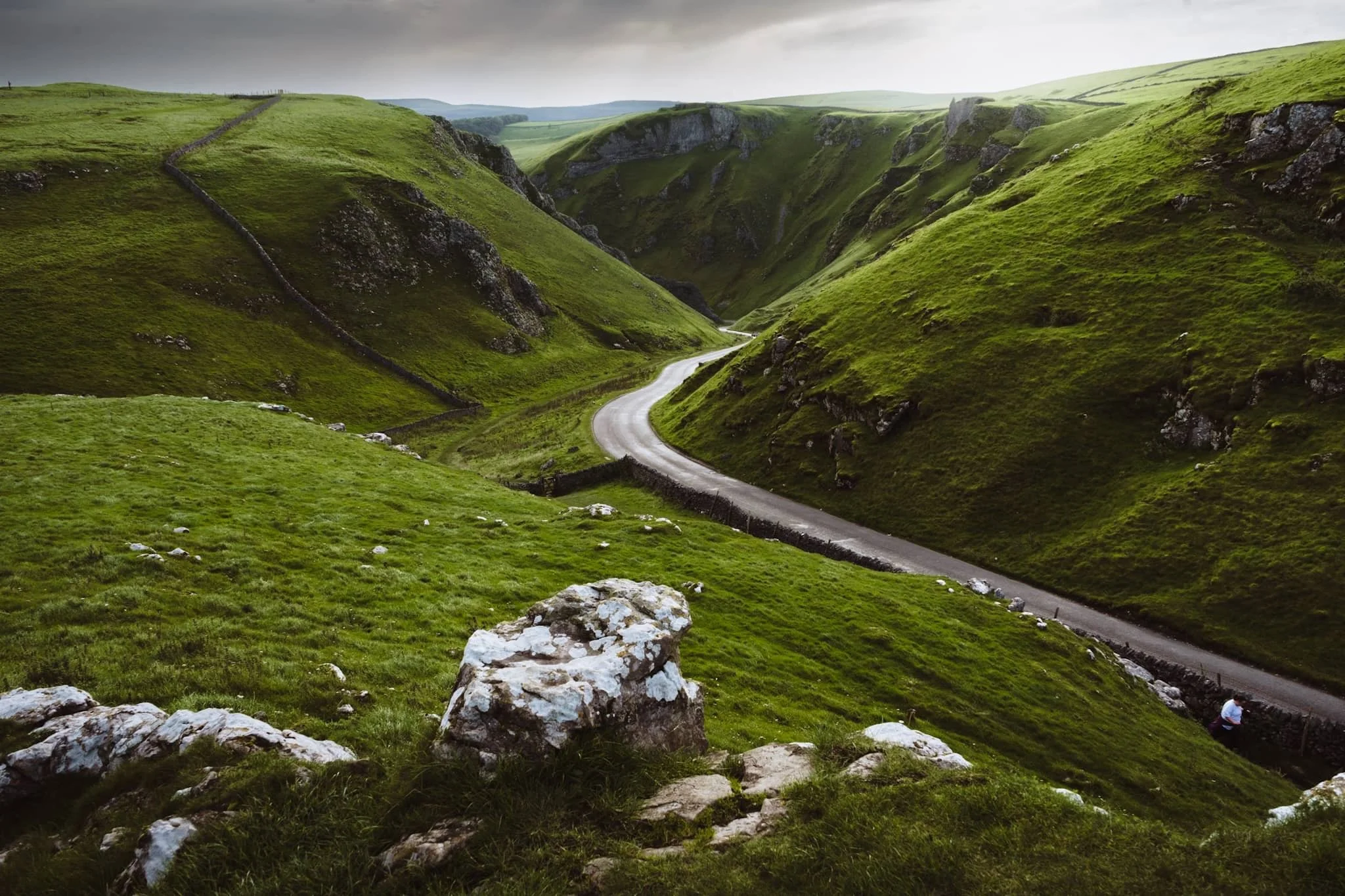
On the way up Mam Tor, the view back towards Winnats Pass reveals the dramatic drop of the gorge. It was once believed to be a giant collapsed cave, but evidence suggests it formed around an underwater canyon. Over time, other rocks covered this area. Much later, erosion revealed the pass we see today, shaped by melting water finding weak points in the rock.
As we climb higher, I find a sheep on the shoulder of Mam Tor, seemingly enjoying the views towards Edale.
Beyond the summit of Mam Tor, at 517 m / 1,696 ft above sea level, our next goal was clear in front of us: Hollin’s Cross and Back Tor along the Great Ridge.
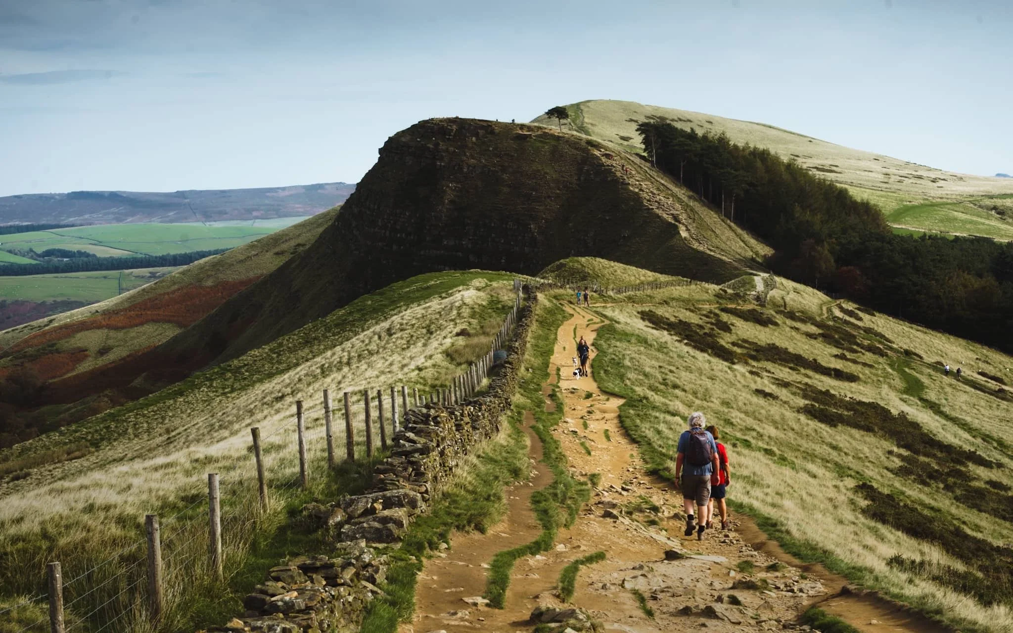
Near Hollin’s Cross, fellow hikers rest and take the time to enjoy the extensive panoramic views across Edale.
Looking back along the ridge from Hollin’s Cross reveals profile of Mam Tor. The hill is also known as Shivering Hill, as its southeastern face near-constantly sheds rocks and causes landslips. In fact a long-established road underneath this side of Mam Tor, the A625, was abandoned in 1979 due to the constant need to repair the road after landslides.
Beyond Hollin’s Cross, our next destination was unmistakeable: the hulking crag of Back Tor.
Back Tor has similar geology to Mam Tor, and as such what you see is the result of a large shale landslip that falls dramatically down to the valley floor of Edale.
After falling on my arse a few times navigating the muddy trail down from the Great Ridge (and getting punctured by gorse on both occasions), I’m relieved to finally locate a paved country lane. Happily, it was also a nice composition to record.
From almost everywhere in Castleton, the towering crags of Winnats Pass are never far away.
Friends enjoy a pint outside the Bulls Head, whilst Mam Tor’s southeastern face rises clearly in the distance.
Did you enjoy these photos?

Kingsdale, Yorkshire Dales, Autumn
Flexibility can lead to great things.
Flexibility can lead to great things.
We started a promising Saturday morning with a plan to hike up the highest peak in the Yorkshire Dales: Whernside (736 m/2,415 ft).
It would definitely be the highest peak we’ve ever ascended but we were planning to “cheat” a little bit. Below Whernside’s western flank is a valley called Kingsdale. There’s a road that runs from the south, near Ingleton, through and over Kingsdale before dropping back down into Dentdale. This road enjoys a few large passing places, one of which is near the summit of the road at 468 m a.s.l. In theory, we could park at the passing place and hike the minor trail up Whernside’s western flank to reach the summit, with only 300 m of actual ascent needed.
We didn’t go for it in the end. Parking in passing places is generally a no-no, and the trail and landscape around Whernside’s western flank looked rather boggy.
Instead, we drove back down to the valley bottom of Kingsdale and stopped at an actual parking place. Here we elected for a hike up Kingsdale’s magnificent limestone fellside to locate the magnificent Cheese Press Stones.
It turned out to be a great idea on a beautiful day.
All photos shot on my Sony α7ii using my Sony FE 28–70mm f3.5–5.6 OSS zoom lens. RAWs developed in Lightroom using RNI Films’ Kodachrome film profiles, finalised in Photoshop.
Kingsdale, Yorkshire Dales, Autumn by Ian Cylkowski is licensed under CC BY-NC-SA 4.0![]()
![]()
![]()
![]()
Straight away from our little parking bay, the views across to Twistleton Scar and Ingleborough were magnificent. They were only going to get better.
The road north through Kingsdale, with the valley’s fantastic scar looming directly above. The main scar above the road is known as Keld Head Scar. The start of the hike heads up the fellside just as the road veers right.
Part way up Keld Head Scar, and a single tree growing out of a limestone boulder provides a nice subject with Whernside in the distance.
As we clamber through the irregular clints and grikes of limestone, and navigate the occasional boulder, Ingleborough emerges from above Twistleton Scar. An old drystone sheep pen provides a nice foreground subject contrast against the fell in the distance.
A large cluster of limestone boulders, no doubt dumped in position by the last Ice Age, provide a nice foreground focal point. They also, happily, seem to “point” towards Ingleborough.
Finally, after a fairly challenging hike and scramble through Keld Head Scar, we emerged onto a limestone plateau where we easily spotted the Cheese Press Stones. These are a pair of giant limestone boulders, probably deposited here after the last Ice Age. Why are they called the “Cheese Press Stones”? No idea.
The boulder on the left is a good 9–10 ft tall. Some estimate its weight at around 15 tons. Here, an obvious composition is hard to ignore, using the two boulders to centre and frame Ingleborough.
A few yards away, I spot another interesting limestone boulder, which appears to me almost like a cracked open egg.
Further up the plateau, a group of large limestone boulders attract my attention. I line a composition, attempting to fill the frame with them whilst keeping Whernside visible in the distance.
I circle around the cluster of boulders to find a composition featured Ingleborough. It means shooting directly into the sun, but thankfully Sony RAW files are incredible flexible.
I locate Lisabet near North End Scar, perched atop a small crag, happily editing her photos. In the distance, the Forest of Bowland is just about visible.
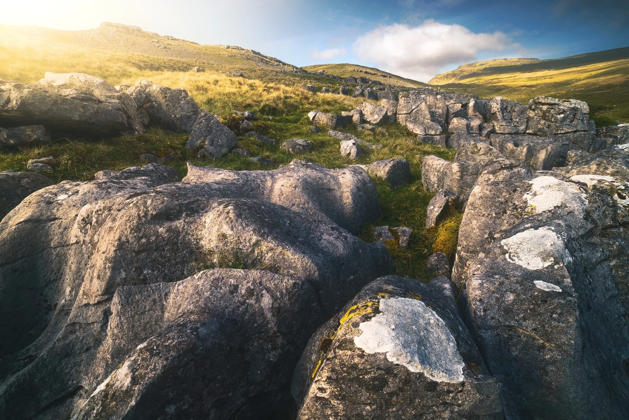
The way back involves navigating this ankle-breaking limestone pavement to relocate the minor trail, which takes you below North End Scar, past Tow Scar, and back down to the road.
Beneath North End Scar’s western edge, the layering and striations of the limestone is fascinating.
I am a sucker for a good drystone wall composition.
The criss-crossing and weaving of the valley and its various limestone scars and layers provide me a delightful photo with Whernside high in the distance.
Nearly back at the car, with the limestone scar of Kingsdale’s western edge in full display. A beautifully sculpted glacial valley.
Did you enjoy these photos?
Crina Bottom, Yorkshire Dales, Spring
After returning from North Wales, but before returning to work, Lisabet and I decided on a wee spring jaunt up to Crina Bottom.
After returning from North Wales, but before returning to work, Lisabet and I decided on a wee spring jaunt up to Crina Bottom.
Crina Bottom is a 400-year old farmstead situated above Ingleton and below the peak of Ingleborough. The route to summit Ingleborough from Ingleton via Crina Bottom is one of the most popular trails to top this famous peak. As such, it’s nicely paved all the way, allowing for easy hiking as the views become increasingly gorgeous.
Once at Crina Bottom, one can enjoy a ridiculous view straight to the flat-topped mountain that is Ingleborough. Just beyond the farmstead, limestone clints and grikes are a photographer’s paradise for compositions.
Plus, we had gorgeous light too.
All photos taken on my Sony α7ii using my Sony FE 28–70mm f3.5–5.6 OSS zoom and Rokinon 14mm f2.8 ED AS IF UMC ultra-wide prime lenses. RAWs developed in Lightroom for iPad, then edited and finalised in Affinity Photo 2 for iPad.
Crina Bottom, Yorkshire Dales, Spring by Ian Cylkowski is licensed under CC BY-NC-SA 4.0![]()
![]()
![]()
![]()
Hiking up Fell Lane to Crina Bottom, a glorious day made shooting this landscape impossible to ignore.
Crina Bottom farmstead with mighty Ingleborough rising above in the distance. Not a bad spot to call home, eh?
Life… finds a way.
Above the farmstead, one can a lovely patch of limestone clints and grikes to play around with and try out some compositions.
Lisabet, perched on a limestone clint, enjoying the view to Ingleborough.
Evening sun bursts from behind a cloud, pulling out all the delicious textures and forms of the limestone rocks, and brushing a paint stroke across the face of Ingleborough.
Did you enjoy these photos?

Eggerslack Wood & Hampsfell, Cumbria, Autumn
The weekend arrived and it finally stopped raining.
The weekend arrived and it finally stopped raining.
To celebrate, Lisabet and I explored somewhere often overlooked by us and perhaps many others. Heading west from Kendal towards Barrow-in-Furness lies the coastal town of Grange-over-Sands.
It’s a proper bonny little place, with a reputation in Cumbria of being almost exclusively inhabited by pensioners, which is saying something as Cumbria itself has an older demographic than the national average. In fact, Cumbria’s 65+ population is 32% higher than the average in England, whilst the 15–64 demographic is 5% lower than the English average.
Above Grange-over-Sands is a small hill known as Hampsfell. Lisabet and I have never hiked up there before, and we were delighted with what we found! Expansive 360º views, limestone pavements, and a lovely woodland beneath the fell.
All photos taken on my Fujifilm X-T2 using my Vivitar “Series 1” 28–105mm f2.8–3.8 zoom and Laowa 9mm f2.8 prime lenses. RAW files were converted in Capture One for iPad, developed in RNI Films, and finalised in Affinity Photo 2 for iPad.
Eggerslack Wood & Hampsfell, Cumbria, Autumn by Ian Cylkowski is licensed under CC BY-NC-SA 4.0![]()
![]()
![]()
![]()
Near the entrance to Eggerslack Wood, we found a cottage completely surrounded in superb autumn foliage. It’s not much of a composition, but I couldn’t resist shooting it.
Eggerslack Wood reminds me a lot of Serpentine Wood in Kendal, and it’s not surprising. Both are woodland growing from a limestone landscape, with a similar biome.
The last of the year’s autumn foliage in Eggerslack Wood, burning bright on an unseasonably warm November day.
Climbing steeply up and out of Eggerslack Wood, we found ourselves on the slopes of Hampsfell. And a happy find for me: limestone pavements!
A solitary tree rises high from the limestone landscape.
Though nowhere near as extensive or as complete as somewhere like Ingleborough or Malham, the site of these sections of beautiful limestone pavement was truly welcome.
A got incredibly low and close to the limestone pavement in order to record the lines and light towards the tree. The final photo was made up of four f8 shots at different focal lengths, focus stacked together for sharpness throughout the frame.
Higher up the fell, more glacial erratics and tor-like features revealed themselves to me for more tantalising compositions.
Even below the summit, the views across Morecambe Bay were extensive. You can even pick out the flat-topped summit of Ingleborough in the Yorkshire Dales, 30+ miles away.
Climbing up and around the shoulder of Hampsfell, a crystal-clear view of the Coniston Fells in the Lake District made us both gasp.
This structure at the summit of Hampsfell is Hampsfell Hospice. It was constructed in 1846 by the Vicar of Cartmell to provide shelter and relief for weary travellers crossing the fell. It does enjoy extraordinary 360º views.
Limestone glacial erratics, windswept trees and the Lake District fells on a ridiculously warm November day.
The trifecta of tree, boulder, and fells.
No series of photos in Cumbria is complete without featuring the local sheep.