Oronsay, Isle of Skye, Scotland, Spring
We’ve only been to the tiny isle of Oronsay once before.
We’ve only been to the tiny isle of Oronsay once before.
This was back in autumn 2020, before the 2nd pandemic lockdown happened.
Conditions on that occasion were cloudy, flat, and grey. But still, the scenery and views were stunning and we vowed to return again.
And so we did, this time with bright spring skies. A world of difference!
Oronsay can be found in Loch Bracadale, along with lots of other little islands, sandwiched in between the Duirinish and Minginish peninsulas. It’s possible to access Oronsay on foot via a tidal causeway consisting of ankle-breaking fist-sized rocks.
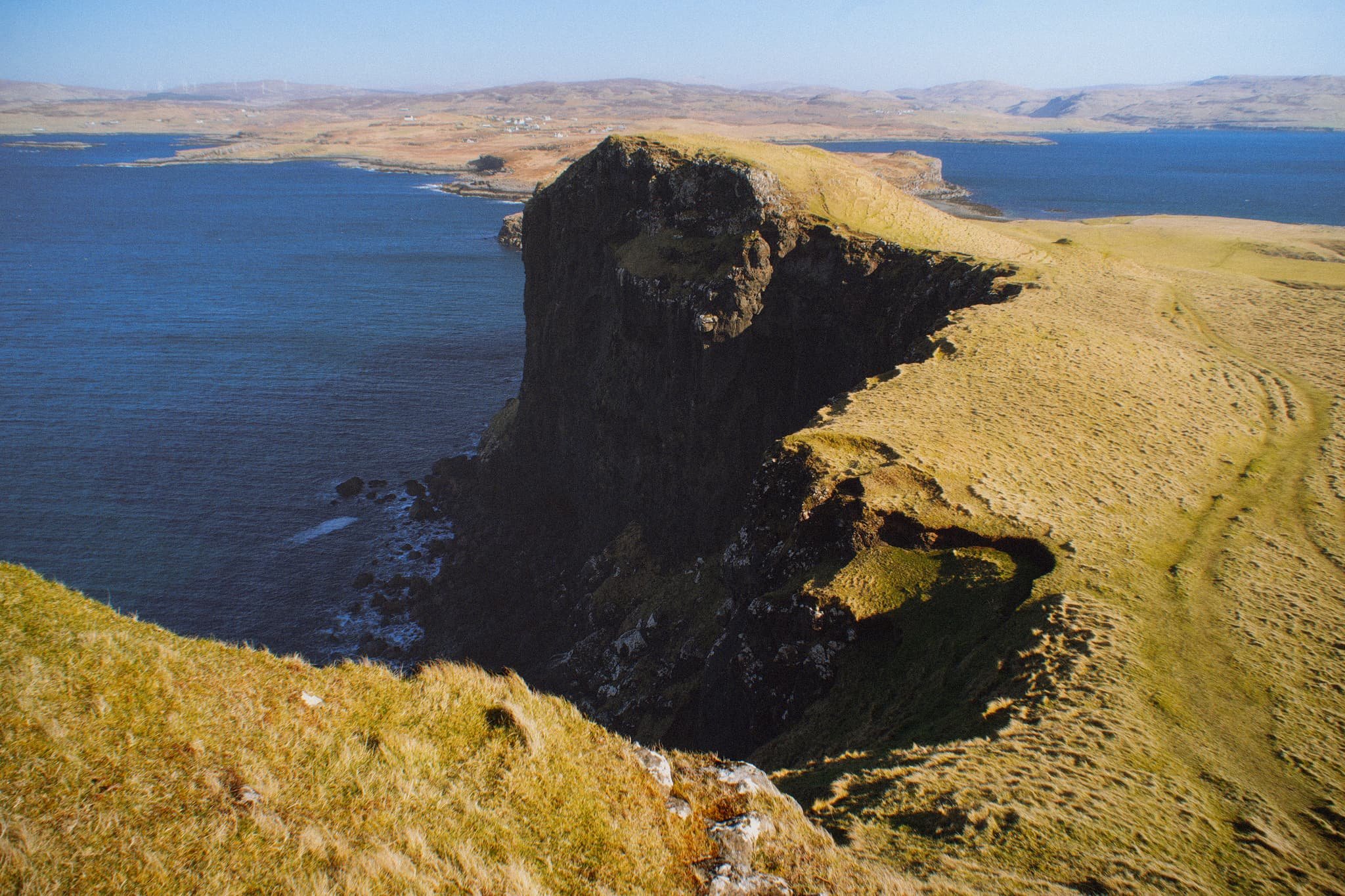
Though only 44 acres in size, it features cliffs 240 ft high, which means it offers incredible views to either the cliffs and hills of the Duirinish peninsula, or the cliffs and Cuillins of the Minginish peninsula.
We didn’t see another soul.
All photos taken on my Sony α7ii using my Pentax SMC 28mm F3.5 prime and Vivitar “Series 1” 70–210mm f2.8–4.0 zoom lenses. RAWs developed in Lightroom using RNI Films’ Kodachrome film profiles, edited and finalised in Photoshop.
Oronsay, Isle of Skye, Scotland, Spring by Ian Cylkowski is licensed under CC BY-NC-SA 4.0![]()
![]()
![]()
![]()
From the mainland at Ullinish it’s a simple, if squelchy, walk from the settlement to the coast. The way to Oronsay then becomes clear; at low tide, the sea is parted by a causeway of boulders and rocks.
Once on the island it’s simple enough to navigate your way towards the highest cliffs. Once there, you get stunning views like this. Zoomed in, the island of Wiay is clear and you can even make out the cliffs and sea stacks of MacLeod’s Maidens.
Looking further east, the eastern end of Wiay gives way to the two distinctive flat-topped hills on the Duirinish peninsula, known as MacLeod’s Tables. The one on the left―MacLeod’s Table South or Healabhal Bheag―is 489 m/1,604 ft. The one on the right―MacLeod’s Table North or Healabhal Mhòr―is 469 m/1,538 ft.
From Oronsay’s tallest cliff, the view northeast down the island and across the loch all the way to Skye proper is just stunning.
Looking back at the tallest cliff, it’s contrasty shape and shadow is used to frame the distant island of Wiay and Duirinish cliffs.
My little Lisabet hiking her way up to the next cliff, whilst I shuffled as close as I dared to the precipitous edge for this monstrous view.
A simple leading line of Oronsay’s cliff edges, all the way back to Ullinish and the moorlands of Skye.
Returning to the lowest part of Oronsay, I venture around its more boggy eastern area for a view back to the craggy cliffs, again using the harsh light and shadow to aid in a leading line composition.
Did you enjoy these photos?

Oronsay, Isle of Skye, Autumn
The Isle of Skye is, of course, an island, but it’s also home to lots of satellite isles in its waters.
The Isle of Skye is, of course, an island, but it’s also home to lots of satellite isles in its waters.
Most of these tiny isles can be found in Loch Bracadale, a sea loch off the coast of Northwestern Skye. It contains isles such as Harlosh Island, Tarner Island, and Wiay. In addition, there is a fourth island that’s actually accessible by foot from the mainland of Skye, but only at low tide.
This is Oronsay.
We ventured to this tidal island from the nearby settlement of Ullinish after a wonderfully hearty Sunday Roast at Bog Myrtle Café. We crossed the shallow gravel bank that links Oronsay to Ullinish at low tide and went exploring this uninhabited island.
The eastern part of Oronsay consists of low lying grassland, and there were definitely plenty of sheep around taking advantage of this. The land then rises up towards the southwest, summiting at 74 m/242 ft and dropping as sheer cliffs down into the sea.
The hike to and around Oronsay was definitely one of the highlights of this particular stay on Skye.
All photos shot on my Fujifilm X-T2 using both my Samyang 35mm f/1.2 and Laowa 9mm f/2.8 lenses. Taken using a customised Pro Negative Standard film profile.
Plenty of rust-coloured bracken on the slopes of Ullinish Point, beyond which lies the tidal island of Oronsay. In the distance is the coastline of Fiskavaig Bay.
Looking back from Ard nan Gamhain towards the tiny settlement of Ullinish.
This is the shallow gravel bank that connects Ullinish Point to Oronsay at low tide. Beyond are the unmistakeable shapes of MacLeod’s Tables; a pair of flat-topped hills that are characteristic features of the Duirinish peninsula of Skye.
Always remember to look at where you’re standing, because I did and found this delightful and somewhat chaotic array of plant life by my feet. I think this might be Rosa pimpinellifolia, the Burnet Rose.
Up on Oronsay we make our way straight towards the 200+ ft high cliffs, snagging compositions along the way.
My lovely Lisabet at the summit of Oronsay and a sheer 240 ft drop next to her. Incredible scenes.
A composition leading towards the southernmost point of Oronsay. To the right, nearest, is Wiay, the largest island in Loch Bracadale. Further, to the right, is Idrigill Point of the Duirinish peninsula of Skye, and you can even just make out the hills on South Uist of the Outer Hebrides, 50 km away.
There was plenty of fascinating geology around Oronsay and Ullinish Point to entertain an amateur Rock Nerd like me. I grabbed a composition of this remarkable boulder, which lie roughly halfway between Ullinish Point and Oronsay.