Colwith Force, Lake District, Autumn
The last of the summer holidays.
The last of the summer holidays.
After a lovely Friday evening in Dentdale, and a glorious Saturday in Kingsdale, we returned to the Lake District on Sunday for a hike to Colwith Force and back.
The weekend saw the advent of a heatwave settling over the British Isles. To counter, we head to Skelwith Bridge early in the morning for cooler conditions and before the majority of summer holidayers were about.
We were rewarded with beautifully moody, misty conditions to start, then as the temperatures rose the mist burned off, swirling around the fell tops and creating dramatic scenery. Just perfection.
All photos taken on my Sony α7ii using my Sony FE 28–70mm f3.5–5.6 OSS zoom and Rokinon 14mm f2.8 ED AS IF UMC ultra-wide prime lenses. RAWs developed in Lightroom using RNI Films’ Kodachrome film profiles, finalised in Photoshop.
Colwith Force, Lake District, Autumn by Ian Cylkowski is licensed under CC BY-NC-SA 4.0![]()
![]()
![]()
![]()
Typically, we start the walk to Colwith Force from Skelwith Bridge. From here we cross the River Brathay and head west. But before crossing the river, we can never resist getting up close and personal with the beautiful Skelwith Force.
Looking upstream from Skelwith Force. You can just about make out the bridge that takes you across the river.
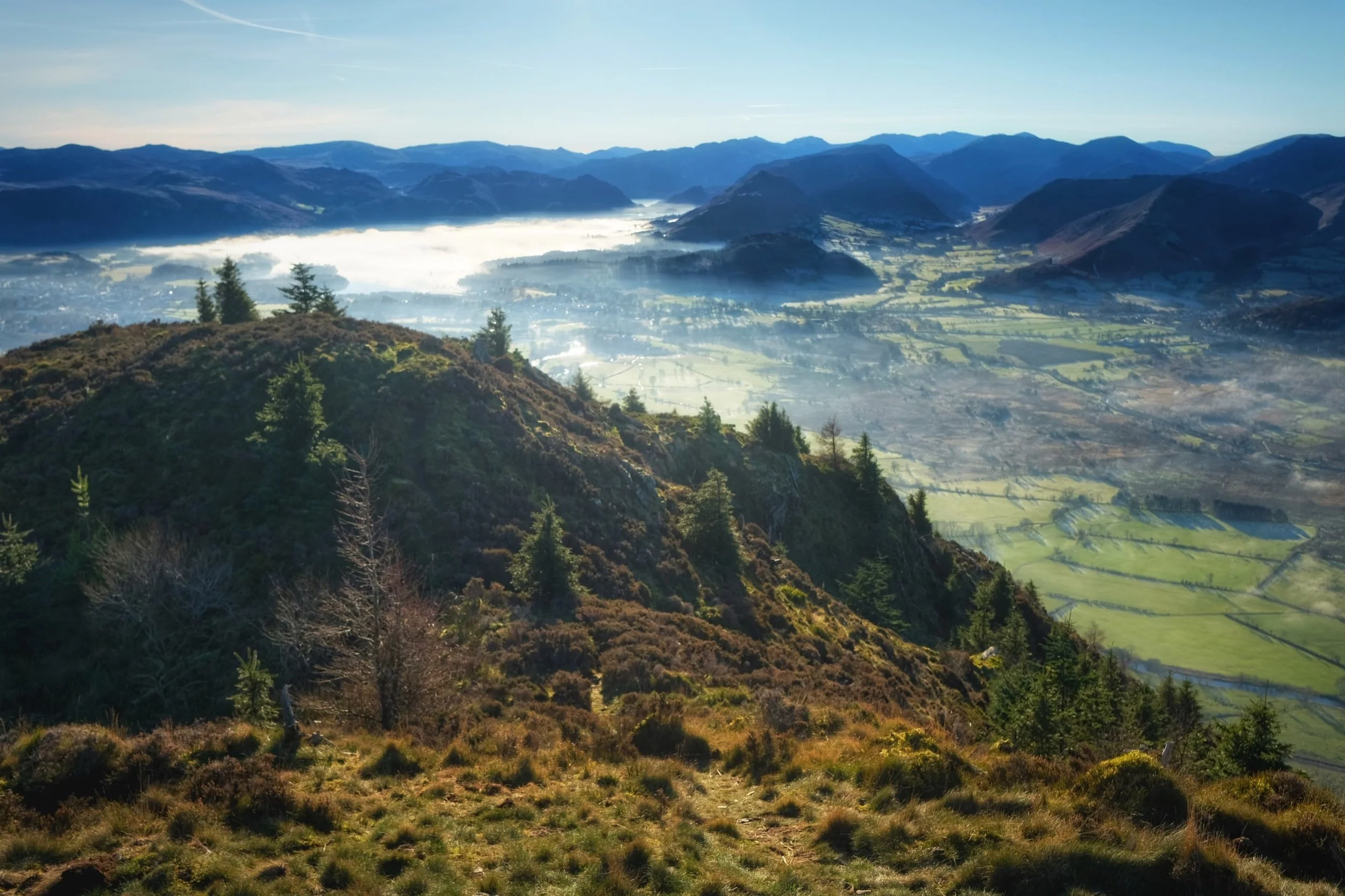
Up and out of the woods around Skelwith Force, we head west where the views started to open up. Well, to a degree. Early morning fog clung to the fell tops, making for moody images.
Looking back down the route we came up. You can just about make out the knuckly profile of Loughrigg but nothing beyond.
After navigating a series of narrow footpaths punctuated with tight kissing gates and stiles, the trail starts to head back down Little Langdale. But before we do, this magnificent composition demands your attention: Wetherlam (763 m/2,502 ft) fighting the swirling mist as the morning sun burns it all off.
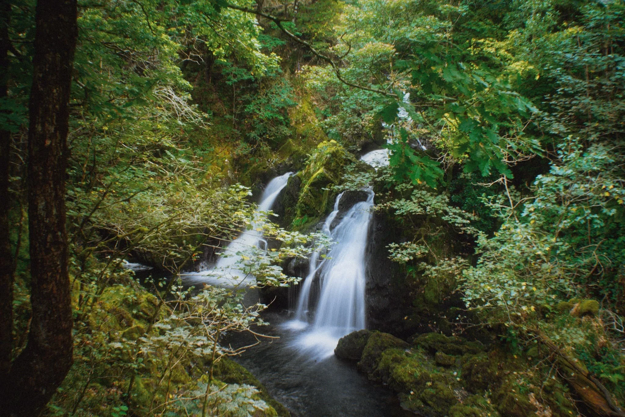
Down at the valley bottom we entered Tongue Intake Plantation and picked our way up through the woods to find our main goal for the day: Colwith Force, a double spout waterfall. Evidence of the approach of autumn is all around us.
Some people simply turn around and head back, but we’re fans of following the trail as it ascends up and above the waterfall. From above it, interesting compositions can be found of all the falls before the main double spout.
Though a little dry this time, there’s a lovely series of falls above Colwith Force that deserve attention.
Beyond the upper falls we followed the circular trail back out of the plantation and sought the Little Langdale road back towards Skelwith Bridge. Emerging from the woods, the fells were now clear of the morning mist, revealing their autumnal coats.
Just goes to show the massive difference a change of light conditions can do to the mood and feel of a photograph. Loughrigg and the Grasmere fells beyond, now clearly visible.
Herdwick yows (ewes) and their lambs peacefully graze in the now gorgeous autumnal morning sun. A timeless scene.
Nearing Skelwith Bridge, we could finally see the Langdale Pikes after being consumed by the fog all morning.
Did you enjoy these photos?

Reston Scar, Lake District, Winter
After the recent freeze, winter fog has descended over the land.
After the recent freeze, winter fog has descended over the land.
It’s been soupy thick and still, gently drenching everything and chilling bodies down to the bone.
Over the weekend, the outdoors called us—as always—and so we tried somewhere a little different. Above the village of Staveley, which also serves as the entrance to Kentmere, a small yet imposing fell dominates the skyline: Reston Scar. It may only be 834 feet (254 m) in height, but it’s relative isolation allows for cracking views…
If you could see them past the fog.
Still, it made for wonderfully moody and wintery photos.
All photos taken on my Fujifilm X-T2 using my Vivitar “Series 1” 28–105mm f2.8–3.8 zoom lens. RAWs converted in Capture One for iPad, processed in RNI Films’ Kodak Portra 400 profile, finalised in Affinity Photo 2 for iPad.
Reston Scar, Lake District, Winter by Ian Cylkowski is licensed under CC BY-NC-SA 4.0![]()
![]()
![]()
![]()
The southern aspect of Reston Scar drops steeply down to the village of Staveley, allowing for—potentially—extensive views.
Near the summit lies Kemp Tarn. I don’t know if it’s any good for wild/outdoor swimming, but on this day it was completely frozen over. I’d have got closer to its shore but the surrounding land was boggy, even in these temperatures.
The edge of Reston Scar, looking over to Craggy Wood/Piked Howe, before it drops right down to Staveley village.
I enjoyed the intersecting lines of the stone wall and the fell slopes.
The summit cairn of Reston Scar, with the merest hint of Ings village below.
In better light, I’d like come back to Reston Scar and explore more of these craggy formations I found. I’m sure there’s some rad compositions to be had.
For now, these will have to do.
Did you enjoy these photos?
Dodd, Lake District, Winter
Thankfully a dry, if bitingly cold, weather system has descended on the British Isles.
Thankfully a dry, if bitingly cold, weather system has descended on the British Isles.
On the Saturday, Kendal was engulfed in a soupy-think mist. It almost seemed to muffle the world in a pillow. In actuality, a temperature inversion sat on top of a lot of Lake District valleys, including Kendal. Conditions above the inversion were clear, sunny, and bright.
So, for the Sunday, we decided to head to the Northern Lakes for a hike up Dodd, part of the Skiddaw range. Local weather reports indicated that a temperature inversion would continue to cling to the fells below 450 m or so, but otherwise the day would be sparkling clear above. Dodd measures 502m above sea level.
In the end, the temperature inversion wasn’t quite as extensive around the Northern Lakes, mostly sitting on top of Derwentwater. Nevertheless, conditions were glorious, the Lake District was quiet, and hiking Dodd is always a good exercise.
All photos shot on my Fujifilm X-T2 using my three prime lenses: a Fujinon 23mm f/2.0, a Laowa 9mm f/2.8, and an adapted Pentax SMC 55mm f/2.0. Images were bracketed handheld, merged and blended in Affinity Photo, then finalised in Snapseed.
The Old Sawmill Tearoom, at the car park below Dodd. A beautifully quaint and cosy place.
Hiking up Dodd is simple enough. Just the follow the green signposted trail. As we did we rose above the leftover mist in the woods, and the sun pierced through the woodland.
Most of Skiddaw, like a lot of Lakeland fells, lacks significant tree cover. Dodd’s an exception, and its dense woodland is managed by the Forestry Commission.
Couldn’t resist snapping a composition of this Sleepy Hollow-esque tree, seemingly pointing the way up through the woodland.
As we started to emerge above Dodd Forest, more of the fell’s rough and craggy summit becomes apparent.
One of many incredible views you can enjoy around the summit of Dodd. Above the woods and the temperature inversion, a clear sight towards the Helvellyn range reveals itself.
It’s hard to keep up the hiking momentum when panoramic views like this constantly vie for your attention.
Nearing the summit of Dodd. To the left a temperature inversion clings to the surface of Derwentwater, creating a lake-sized mirror reflecting the morning sun. To the right are the Newland fells; tiny tufts of fog cling to dales below.
From the summit of Dodd. Bassenthwaite Lake was impossibly still, and the atmosphere was clear that you could see all the way across to the Cumbrian coast and beyond to Galloway in Southwestern Scotland.
We rested on the summit for coffee and fruit, but I had to snap another composition looking back to the magnificent shapes of the Helvellyn range.

With my 55mm attached I tried for some focused compositions of some of the nearby fells from Dodd summit. The wooded fell here is Barf (yes, that’s right).
The shapely peak pictured above the dale here is Grisedale Pike.
As we started to descend, more compositions offered themselves to me. Immediately above is the southern face of Carl Side with Little Man behind it.
The way back down Dodd’s southern aspect is quite steep, but no less beautiful.
As we near the bottom, Ullock Pike glows in the midday wintersun.
Despite being in winter, Skill Beck was surprisingly lush and verdant.
The remnants of Storm Arwen’s destruction made for some nice ultra-wide compositions.
There’s a lot of lush fern to be found alongside Skill Becks many mini waterfalls.
Another casualty of Storm Arwen, now left where it fell to provide life and nourishment for all denizens of the forest.

Kendal, Cumbria, Winter
Wow, it’s been nearly a month since my last post.
Wow, it’s been nearly a month since my last post.
Well as you know, Storm Arwen took autumn away and brought winter with it. In addition, it left behind lots of infrastructure damage. Families were left without power for a week or more.
So getting out and about has been difficult because of blocked roads and whatnot. But additionally, it has been wet, damp, drizzly, and miserable, severely limiting our prospects for getting out into nature.
Thankfully, we’ve entered a cold period, so the rain has disappeared. In its place is cold mist and fog, which we took advantage of with a wee waltz around beautiful Kendal.
All photos taken on my Fujifilm X-T2 using my Laowa 9mm f/2.8 and Fujinon 23mm f/2.0 prime lenses. Shots were exposure-bracketed handheld then merged, tonemapped, and edited in Affinity Photo. Finished off in Darkroom.
Whilst waiting for Lisabet, I noticed the winter morning light catching the top of the buildings above Highgate. A quick seven exposures later gave me this scene.
Whilst in town centre we nipped into Bobbi’s for arguably Kendal’s best flat white. When we came out a temperature inversion had descended on the town, covering the world in a soft and silent mist.

Stramongate Bridge and its weir, looking especially beautiful in the low winter light and misty conditions. There’s been a bridge here across the River Kent since the 14th century, but it’s current incarnation has been standing since 1794.
Then my Lisabet had an inspiring idea (as she usually does): why not visit Castle Street Cemetery? It’s always a good place to visit in moody conditions. She wasn’t wrong.
Probably the best shot from the whole day. Full of mood.
We navigated our way back home via the shoulder of Kendal Castle. There’s something about woodland in fog that speaks to something primal and ancient.
Fletcher’s Park always has some weird and wonderful trees. Good to see a lot of them survived Storm Arwen.
Not to mention a throne carved from a tree stump.

Newton Point, Northumberland, Summer
Ah haar, there’s a sea fret rolling in.
Ah haar, there’s a sea fret rolling in.
Early on in our Northumberland break we fancied a hike around Embleton Bay, to shoot photos of the bay’s massive and smooth black basalt boulders with views towards the ruins of Dunstanburgh Castle.
However, plans change. As we neared the bay it became clear (or rather, it didn’t) that a “haar” or sea fret had rolled in off the North Sea, covering the whole Northumberland coastline in thick fog. There were no views to be had of the castle ruins.
Instead, we followed trail—known as St. Oswald’s Way—north, passing through the National Trust village of Low Newton-by-the-Sea towards Newton Point. We ventured with open eyes and mind, which was good because Newton Point was an absolute delight that we no idea about.
Additionally, the haar provided an atmospheric aura to some of my photos, which I’m happy to take.
All photos shot on my Fujifilm X-T2 using my three prime lenses: a Samyang 35mm f/1.2, a Laowa 9mm f/2.8, and an adapted Pentax 55mm f/2.0. Images made 80% in-camera using a customised Velvia film simulation, with minor edits and corrections afterwards in Lightroom and Affinity Photo.
After parking at Embleton, our hopes were high for wonderful scenes of Dunstanburgh Castle.
Alas, no castle could be seen. The haar had covered the whole Northumberland coastline in a thick fog. Nevertheless, to get to Embleton Bay and the trail from Embleton Village, you have to pass through Dunstanburgh Castle Golf Club. There’s a lot of golf around the Northumberland coast.
Above Embleton Bay, near the Embleton Links golf course, there’s a whole bunch of “beach chalets” or, more accurately, bungalows that sit on National Trust land. On a clear sunny day I’ve no doubt they look adorable and inviting. With the sea fret rolled in, the bungalows presented a more foreboding presence.
Spooky. Zombie film, anyone?
A way down to the sands of Embleton Bay, but my eye was caught by the people walking along the beach, appearing like ghosts as the haar rolled in off the sea.
We close in on the charming village of Low-Newton-by-the-Sea, an old fishing village now almost totally owned by the National Trust.
The village is known for its cream white cottages and open square, with the 18th-century Ship Inn pub right in the middle. A charming place.
North of the village we break away from St. Oswald’s Way and take the private road east towards the coastline, curious to see what was here.
What we found was a coastline of bloom flowers, lichen and moss, and volcanic black boulders everywhere. With the haar in place, the area appeared to me magical and surreal.
Clints and grikes of volcanic basalt rock provided lovely textures and lines for playing around with compositions.
With my ultra-wide 9mm lens, I was able to render some more unusual compositions around here by getting really low and intimate with some of the small channels carved into the rock.
Blossoming flowers and weeds everywhere gave me more opportunities for interesting photos.
The headland of Newton Point houses a former LORAN (long range navigation) station from the Cold War era. Spooky.
We followed the eastern edge of Newton Point around to its northern side, and then—BOOM. This view and these cliffs. We had no idea they were here.
Not massive cliffs by all means, but shapely and beautiful nevertheless.
Columns of dark volcanic basalt stand as a fortress against the unrelenting sea.
The North Sea around here was wonderfully clear and azure. This made it awfully tempting for Lisabet to go for a swim.
Grass and lichen provide gorgeous colour contrast against the azure water and blue fog.
Fantastic colours and views.
From Newton Point we dropped down to the beach northwards known, interestingly, as Football Hole.
The retreating tide left behind these following lines and curves that I had to make a composition of.
The dunes around Snook Point make for some lovely views. At this point the sun even threatened to break through the haar.
Sand dunes that seemingly go on forever…
A beautiful blossom of Geranium sanguineum, otherwise known as bloody crane’s-bill. Also the national flower of Northumberland!
On our way back, the haar was finally starting to burn off courtesy of the midday summer sun. In the distance, cows graze peaceful near a pond.

Patterdale, The Lake District
Today wasn’t forecast to be all that nice in terms of weather, but the best chances were said to be more towards the Eastern Fells.
Today wasn’t forecast to be all that nice in terms of weather, but the best chances were said to be more towards the Eastern Fells.
So Dad and I hopped up and over Kirkstone Pass and down into Patterdale for perhaps a dry-ish waltz around the Grisedale valley. Unfortunately, the expected breeze/wind never arrived and so the murk of mist and drizzle stayed with us throughout our ramblings. Still managed to get some good exercise in and a few moody shots.
All taken on a Fujifilm X-T2 with a Fujinon XC 16-50mm f/3.5-5.6 OIS lens.