The Newlands Round, Lake District, Summer
The Great British Summer Heatwave has arrived.
The British Summer Heatwave has arrived.
In the week leading up to yesterday, Saturday 17th July, I had been planning a fell walk with my friend, Kate. She has more experience fell walking than I do, so we agreed to try a fell walk incorporating a view I’ve been after for years: Dale Head.
As the week progressed, it became apparent that a heatwave would arrive over the British Isles on the day of our walk. So we agreed to get up super early, drive to the location, and start the hike before temperatures became unbearable.
That was exactly the right decision.
Parking up at Honister Slate Mines, we started the steep ascent up the shoulder of Dale Head (753 m/2,470 ft) in comfortable temperatures of 15–16°C and a lovely breeze. By the time we had reached the final fell of the round, Robinson (737 m/2,418 ft), temperatures had risen into the mid-20s and the sun was strong. We had planned it well.
Kate turned out to be the perfect fell walking partner. Relaxed, sensible, and well-provisioned.
Here’s to more fell walking!
All photos taken on my Fujifilm X-T2 using two of my prime lenses: a Samyang 35mm f/1.2 and a Laowa 9mm f/2.8 lens. Images made 80% in-camera using a customised Classic Chrome film simulation, with minor corrections and edits afterwards in Lightroom and Affinity Photo.
The ascent up the shoulder of Dale Head from the Honister Slate Mine quickly opens these incredible views towards Buttermere and the Lorton Vale. Fleetwith Pike (648 m/2,126 ft) on the left was looking magnificent.
Looking back down the path we had taken, now the southern fells were becoming visible. Featuring Base Brown, Grey Knotts, and Green Gable.
At this height, the northern face of Kirk Fell (802 m/2,631 ft) was coming into view.
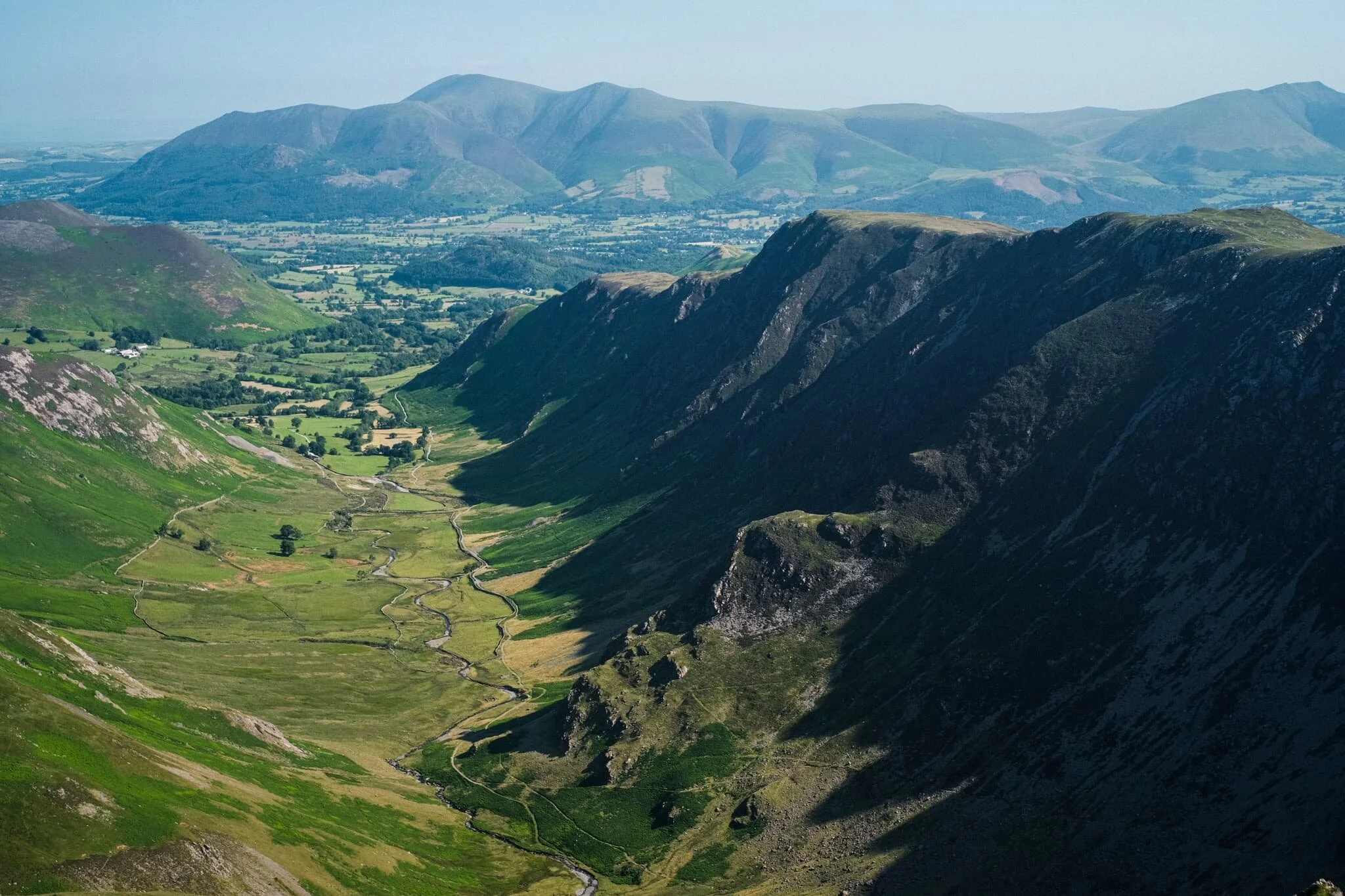
Aaaannddd… summit! The top of Dale Head, featuring its massive cairn and, more importantly, the ridiculous view if offers all the down the Newlands Valley towards the Skiddaw mountains. 8-years in waiting, and I loved every second.
Though the southern shoulder of Dale Head is steep, it is relatively smooth. By contrast, the fell’s northern face drops 400 m or so in less than a kilometre via Dale Head Crags. This enables this huge open view towards the High Spy and Maiden Moor ridge on the right, and the shoulder of Hindscarth on the left.
Probably my favourite shot of the day. The High Spy and Maiden Moor ridge, with its western flanks dropping sheer to the valley floor in a series of crags. In the distance, the Skiddaw range. Incredible.
Time to rest and refuel, which Kate and I were more than happy to do.
From Dale Head, there are unparalleled views towards the northern face of Fleetwith Pike and even, in the distance, mighty Pillar (892 m/2,927 ft).
West of Dale Head summit it’s easy enough to follow Hindscarth Edge to the next fell, drinking in the views all the way. Here is a clear shot of Buttermere and the massive High Stile range of fells above it.
The view back east shows the sheer craggy drop of its northern face as well as the crags of High Spy. In the distance is the Helvellyn range.
The way forward. Our next goal was to follow Hindscarth Edge and branch off to the right in order to summit Hindscarth itself.
Another view of Fleetwith Pike’s norther face and mighty Pillar in the centre. To the right is High Crag, part of the High Stile range.
Just below Hindscarth Crags I move towards the edge to nab this composition of the High Spy/Maiden Moor ridge with the Skiddaw and Blencathra ranges in the distance. Closer to me, a Swaledale lamb chews the cud and chills.
As we ascend Hindscarth, different views open up eastward. Below is Far Tongue Gill, to the right is Dale Head Crags, and left is Miners Crag and Red Crag of the High Spy/Maiden Moor ridge. In the distance, the Helvellyn range.
And another summit! This time, Hindscarth (727 m/2,385 ft), which offers a wonderful view down to the Newlands Valley floor and the Skiddaw range beyond.
Looking back at the High Stile range, I primarily took this shot for the British Isles-shaped cloud above the fells. You see it?
Being more west than when we started out, the High Spy/Maiden Moor ridge opens up and we can see Catbells (451 m/1,480 ft) as well. In the distance is the beautiful Blencathra fells.
A vertical composition from Hindscarth, looking down the trail to Scope End and the Skiddaw range in the distance. Just incredible views, no matter where you look.
High Spy, Maiden Moor, Catbells with beautiful Blencathra far away.
Kate happily resting by the wind shelter on Hindscarth. Across the valley is our next target, Robinson.
The way to the next fell, Robinson, involves returning back to the Hindscarth Edge trail and carrying onto the Littledale Edge trail towards Robinson. Before we did, I had to capture this panorama of fells from the Hindscarth summit.
Looking back at the Hindscarth Edge trail. Hard to believe we had walked all that way.
The Honister Pass, the top of which marked the start of our hike. We’ve made it quite far. In the distance is Glaramara (783 m/2,569 ft).
Nearing the top of Robinson. The small isolated fell of Rannerdale Knotts comes into view, followed by Crummock Water and Mellbreak above it. We can now see beyond the Lake District out to the Irish Sea.
And the third and final summit! Robinson was definitely the hardest to climb. The top is relatively flat but its sides a rather steep, with paths made largely of loose scree. By the time we reached Robinson, it was midday and temperatures were really starting to climb. I went scurrying around the summit with my ultra-wide lens to shot some of the interesting rock formations.
Utilising our previous route as a leading line towards the fells and featuring this wonderful craggy formation.
Fascinating geology. This is apparently an “olistostrome of disrupted, sheared and folded mudstone, siltstone and sandstone”. I also liked in this composition our the pile of rocks on the right mirrored the shape of the Skiddaw range to the left.
After the rather precipitous climb down Robinson’s northeastern flank to Buttermere Moss, I look back to shoot this profile of Robinson. More as a reminder of what we’d achieved.
What a wonderful day.

Buttermere & Newlands, Lake District: A Winter Series
Though definitely more pedestrian than Wasdale, Buttermere is no less spectacular.
A burst of light breaks through the overcast sky, picking out the details on High Crag’s (744 m/2,441 ft) shoulder.
Though definitely more pedestrian than Wasdale, Buttermere is no less spectacular.
As part of our mid-winter break, Lisabet and I took advantage of the improving weather conditions to head into the Northwest lakes. The valley of the River Cocker contains three lakes, with Buttermere sitting at the head of the valley, then Crummock Water and Loweswater further back respectively.
There is a path all the way round the lake allowing one ample opportunity to enjoy all the views this small lake has to offer, especially looking east-by-southeast towards the pyramidal Fleetwith Pike (648 m/2,126 ft) and the knuckly Haystacks (597 m/1,959 ft).
Afterwards, once we’d adequately refilled, we carefully navigated over the precarious Newlands Pass and dropped down into the Newlands valley. There were a few compositions in particular that I wanted to find and grab; happily, we also made friends with a farm horse along the circuit of the valley bottom.
Always have some spare apples with you.
Please enjoy these photographs of this spectacular part of the Lake District.
If you think other people you know would like them, please feel free share the link to this page across your favoured social media and website of choice.
The cascades of Sourmilk Gill, dropping 400m/1,300ft from High Stile (807 m/2,648 ft) above.
Soumilk Gill from its foot, which exits right near the shores of Buttermere.
My little Lisabet, crouching by the shore of Buttermere to get a composition. Looming in the distance is the beautiful Fleetwith Pike.
Two older hikers make their way to the shore of Buttermere with Fleetwith Pike in the distance.
Out of the woods and into the open fellside. Fleetwith Pike remains steadfast in our view, but Haystacks starts to make an appearance towards the right.
Getting closer towards the head of the valley, known as Warnscale Bottom. Fleetwith Pike and Haystacks make a stunning pair on the skyline.
A better look at the fist-like summit of Haystacks, Alfred Wainwright’s favourite fell. To the right of the fell is a little nook called Scarth Gap, which is a steep bridleway allowing access into the next valley: Ennerdale.
Looking south from the head of Buttermere, a burst of light illuminates some trees and a hiker near the shore.
Sunlight escapes through the clouds, highlighting the details in High Pike’s craggy foot. The ancient woodland at the shore of Buttermere continue getting battered by the high winds and waves.
The setting sun illuminates the eastern shore of Buttermere with Fleetwith Pike looming large above.
Snowdrops, Galanthus nivalis. To my mind, the first sign that spring is on its way.
An expansive view of the western section of the Newlands valley, shot from near the summit of the Newlands Pass. In the distance, Blencathra (868 m/2,848 ft) catches some golden light from the setting sun.
One of the compositions I’ve been after for some time. Shot from the eastern section of the Newlands valley near Little Town, the fell path gives way to a spectacular view of Scope End (412 m/1,351 ft), Hindscarth on the left (727 m/2,385 ft), and Robinson on the right (737 m/2,418 ft).
The last of the day’s light, streaking across the multi-faceted face of the Skiddaw massif (931 m/3,054 ft).
I hope you enjoyed viewing these photos as much as I enjoyed shooting, editing, and sharing them.