
Berwick-upon-Tweed, Northumberland, Summer
Here’s the final collection of work from our week-long summer jaunt around Northumberland.
Here’s the final collection of work from our week-long summer jaunt around Northumberland.
Berwick-upon-Tweed is a town steeped in history and filled with curiosities. It’s England’s northernmost town, right in the northeastern corner of the country. In fact, it’s slightly further north than Copenhagen in Denmark as well as the southern tip of Sweden.
Berwick’s name comes from the Old English berewíc, meaning “corn/barley farm”, which I guess gives you an idea of the town’s origins. During a period of about 400 years, Berwick changed hands between England and Scotland a dozen times or so. Richard of Gloucester retook Berwick for England for the last time in 1482. More than 200 years later, the Kingdom of Scotland joined the Kingdom of England in 1707, forming the Kingdom of Great Britain, and ending the border quarrelling between the nations.
A persistent legend exists about the town “technically” being at war with Russia. The myth goes that because Berwick had changed hands several times, it was regarded as a special, separate entity, sometimes referred to in proclamations as "England, Scotland and the town of Berwick-upon-Tweed".
For the declaration of the Crimean War against Russia in 1853, Queen Victoria supposedly signed the proclamation as "Victoria, Queen of Great Britain, Ireland, Berwick-upon-Tweed and all British Dominions". When the Treaty of Paris was signed to conclude the war, "Berwick-upon-Tweed" was left out. This meant that, supposedly, one of Britain's smallest towns was officially at war with one of the world's largest powers – and the conflict extended by the lack of a peace treaty for over a century.
In reality, Berwick-upon-Tweed was not mentioned in either the declaration of war or the final peace treaty, and Berwick-upon-Tweed was legally part of the United Kingdom for both.
Regardless, the town is fascinating and you can feel the dual-nationality personality of the place. During our wandering, a sea fret obscured most of the coastline, lending a misty foggy atmosphere to our photography.
All photos shot on my Fujifilm X-T2 using my three prime lenses: a Samyang 35mm f/1.2, a Laowa 9mm f/2.8, and an adapted Pentax SMC 55mm f/2.0. Developed using RNI Film’s Astia 100f profile.
The Royal Tweed Bridge as the sea fret rolled in. It was constructed in the 1920s, designed to take on the increasing numbers of traffic away from the old Berwick Bridge, which had stood since the 1600s.
The nice thing about the Royal Tweed Bridge is you can get right underneath it and see its “guts”, so to speak. An incredible piece of engineering.
One of our favourite shops in Berwick, Slightly Foxed. The interior of the shop is almost made out of books, there’s so many.
The weird leaning/curved building is the old Granary, now serving life as the Granary Gallery.
An unusually empty Berwick, as we make our way towards the sea.
As we approach the North Sea, a look back reveals the three bridges of Berwick, which cross the Tweed.
Old riverside properties as the Tweed pours out into the North Sea.
We decide to venture out towards Berwick Lighthouse, England’s most northerly lighthouse. It was built in 1826.
Time to whip out my 9mm ultra-wide lens to capture the entirety of the lighthouse.
And lurking behind the lighthouse, a fisherman investigating opportunities in the North Sea.
We decide to exit the pier and continue up northwards along the Berwick coastline, see what’s what.
Welp, this was an unexpected find. The bloated carcass of a whale, long dead and washed up on the shore of Meadow Haven. I couldn’t tell you what type of whale it was.
Further up the Berwick coastline we came across an unexpected and delightful find: a raised platform of rocks and boulders known as Meadow Haven and Bucket Rocks. Let’s explore compositions!
I’m always fascinated by how geometric geology like this comes to be formed.
We pop up through the dunes away from the sea to find a way through the golf course and back into the town.
A lovely clump of Red Valerian amongst the reeds and sand dunes, Centranthus ruber.
Story time! As we made our way back through Berwick town, we stopped outside someone’s house to admire their front garden filled with flowers. Lisabet took some photos. As she did, an old gentleman enquired approached us to ask about our activity. After learning we were just admiring his garden, he simply invited us through to their back garden, which was even more fecund and filled with all sorts of flowers and vegetables. The “lady of house” was very enthusiastic about her gardening, and was more than happy to meet us and run through the garden with her. I snapped this quick portrait of her. What a wonderfully welcoming and friendly pair they were!
Her garden was, indeed, glorious.
After the Surprise Garden Tour we made our way towards the old town walls and military fortifications that surround Berwick-upon-Tweed. Local kids enjoy a game of footie sent against the 500-year old fortifications.
Walkways have been constructed around the old walls and fortifications, but there are still sections that have been preserved.
This area of the walls are known as the Elizabethan ramparts, which were essentially 16th-century upgrades to the existing 14th-century construction.
And back down the old cobbled street.

Newton Point, Northumberland, Summer
Ah haar, there’s a sea fret rolling in.
Ah haar, there’s a sea fret rolling in.
Early on in our Northumberland break we fancied a hike around Embleton Bay, to shoot photos of the bay’s massive and smooth black basalt boulders with views towards the ruins of Dunstanburgh Castle.
However, plans change. As we neared the bay it became clear (or rather, it didn’t) that a “haar” or sea fret had rolled in off the North Sea, covering the whole Northumberland coastline in thick fog. There were no views to be had of the castle ruins.
Instead, we followed trail—known as St. Oswald’s Way—north, passing through the National Trust village of Low Newton-by-the-Sea towards Newton Point. We ventured with open eyes and mind, which was good because Newton Point was an absolute delight that we no idea about.
Additionally, the haar provided an atmospheric aura to some of my photos, which I’m happy to take.
All photos shot on my Fujifilm X-T2 using my three prime lenses: a Samyang 35mm f/1.2, a Laowa 9mm f/2.8, and an adapted Pentax 55mm f/2.0. Images made 80% in-camera using a customised Velvia film simulation, with minor edits and corrections afterwards in Lightroom and Affinity Photo.
After parking at Embleton, our hopes were high for wonderful scenes of Dunstanburgh Castle.
Alas, no castle could be seen. The haar had covered the whole Northumberland coastline in a thick fog. Nevertheless, to get to Embleton Bay and the trail from Embleton Village, you have to pass through Dunstanburgh Castle Golf Club. There’s a lot of golf around the Northumberland coast.
Above Embleton Bay, near the Embleton Links golf course, there’s a whole bunch of “beach chalets” or, more accurately, bungalows that sit on National Trust land. On a clear sunny day I’ve no doubt they look adorable and inviting. With the sea fret rolled in, the bungalows presented a more foreboding presence.
Spooky. Zombie film, anyone?
A way down to the sands of Embleton Bay, but my eye was caught by the people walking along the beach, appearing like ghosts as the haar rolled in off the sea.
We close in on the charming village of Low-Newton-by-the-Sea, an old fishing village now almost totally owned by the National Trust.
The village is known for its cream white cottages and open square, with the 18th-century Ship Inn pub right in the middle. A charming place.
North of the village we break away from St. Oswald’s Way and take the private road east towards the coastline, curious to see what was here.
What we found was a coastline of bloom flowers, lichen and moss, and volcanic black boulders everywhere. With the haar in place, the area appeared to me magical and surreal.
Clints and grikes of volcanic basalt rock provided lovely textures and lines for playing around with compositions.
With my ultra-wide 9mm lens, I was able to render some more unusual compositions around here by getting really low and intimate with some of the small channels carved into the rock.
Blossoming flowers and weeds everywhere gave me more opportunities for interesting photos.
The headland of Newton Point houses a former LORAN (long range navigation) station from the Cold War era. Spooky.
We followed the eastern edge of Newton Point around to its northern side, and then—BOOM. This view and these cliffs. We had no idea they were here.
Not massive cliffs by all means, but shapely and beautiful nevertheless.
Columns of dark volcanic basalt stand as a fortress against the unrelenting sea.
The North Sea around here was wonderfully clear and azure. This made it awfully tempting for Lisabet to go for a swim.
Grass and lichen provide gorgeous colour contrast against the azure water and blue fog.
Fantastic colours and views.
From Newton Point we dropped down to the beach northwards known, interestingly, as Football Hole.
The retreating tide left behind these following lines and curves that I had to make a composition of.
The dunes around Snook Point make for some lovely views. At this point the sun even threatened to break through the haar.
Sand dunes that seemingly go on forever…
A beautiful blossom of Geranium sanguineum, otherwise known as bloody crane’s-bill. Also the national flower of Northumberland!
On our way back, the haar was finally starting to burn off courtesy of the midday summer sun. In the distance, cows graze peaceful near a pond.
Castles & Circles, Northumberland, Summer
This might be a bit of a mish-mash of a post, so bear with me.
This might be a bit of a mish-mash of a post, so bear with me.
One morning, whilst perusing our favourite weather apps and services, we could see that we needed to stay away from the coast if we wanted to avoid the rain and thunder. Being more in-land would be a better deal. So we began looking at our “wishlist” of Northumberland in-land locations and realised that quite a few of them were fair clustered together.
A plan formulated in our heads…
Now, each location here could well have been given its own post. But they would’ve been short posts, and I like giving value for money. So please enjoy this journey through the history, and pre-history, of Northumberland.
All photos taken on my Fujifilm X-T2 using my three prime lenses: a Samyang 35mm f/1.2, a Laowa 9mm f/2.8, and an adapted Pentax SMC 55mm f/2.0 lens. Images made 80% in-camera using a customised Velvia film simulation, with minor corrections and edits in Lightroom and Affinity Photo afterwards.
First stop, Norham Castle! The original tower known as the Great Tower, which is largely what’s left of the castle, was founded by Ranulf Flambard, Bishop of Durham, between 1099 and 1128 AD. It was built to protect the bishopric of Northumberland from the Scots.
That makes Norham Castle over 900-years old! The castle was an important fortification and site against the Scots, and in the course of the next 300 years since its founding the castle was attacked, invaded, and changed hands many times between the English and the Scots.
As peace finally settled between England and Scotland in the 16th century, Queen Elizabeth declared she would spend nothing on Norham and the castle was left to ruin.
It gained fame once again in the 19th century due to the paintings of J. M. W. Turner.
Here I employed some actual HDR photography, first time in many years, in an attempt to capture more dynamic range looking up the stairwell in the Great Tower.
The site and castle is now taken care of by English Heritage, who’ve made access to the area free and have helped maintained accessibility of this historic treasure.
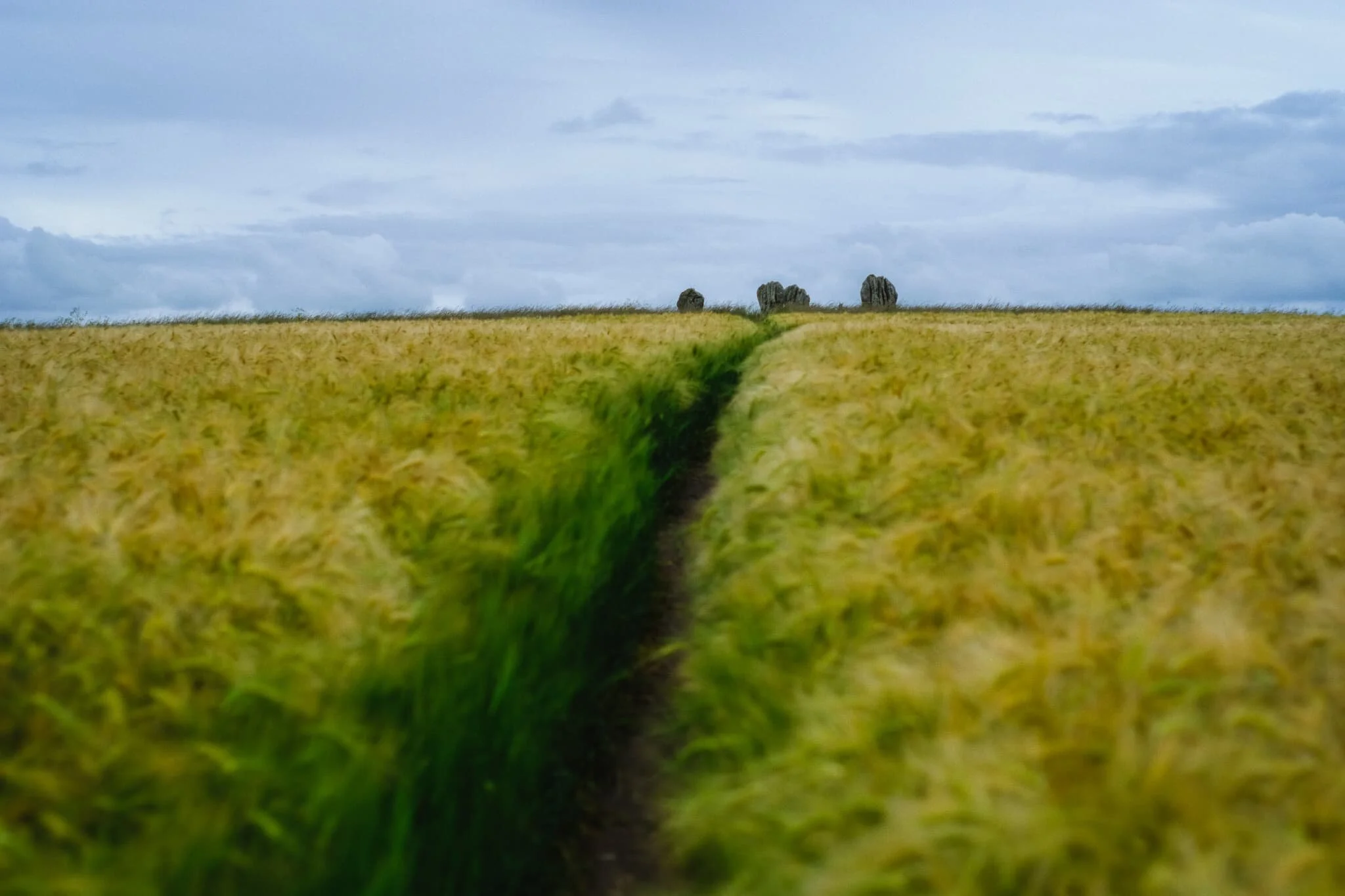
10-minutes south-by-southeast of Norham is the tiny village of Duddo. We parked up at a lay-by just outside the village to take the farmer-permitted access track to Duddo Stone Circle. The land around here seemed primarily used for growing crops of wheat, and their sea-like wavering in the wind mesmerised me.
Halfway along the path the stone circle becomes visible and we could see we weren’t the only ones. Lisabet and I waited by a clearing to give the previous visitors space to leave. One way in, one way out.
Looking back the way we came, the Cheviot Hills were looking rather lovely. Not as lovely as my Lisabet, though.
Our turn up the access track towards the stone circle. Our excitement builds.
And here we are, Duddo Stone Circle. Much more impressive than we had first anticipated, actually! The stone circle is “officially” known as Duddo Five Stones because, well, there’s five stones.
It was previously known as Duddo Four Stones, or just Four Stones, until 1903, when the fifth stone was re-erected to improve the skyline. The evidence, though, indicates that there were originally seven.
The stones are made of local sandstone and are deeply fissured due to weathering, making these incredible shapes. The best guess is that they were erected in the Early Bronze Age, so around 4,000 years ago! Which is crazy to think of.
Duddo Five Stones is located on a small hill north of the village of Duddo, and thus they offer panoramic views of the Cheviot Hills to the south and the Lammermuir Hills to the north. In view in this composition are the Cheviot Hills.
After soaking in the atmosphere of this mystical place, we eventually trundled our way back the same route to the car, drinking in the panoramic views as we did. A humbling place.
Another 4-minutes south of Duddo is the one-street village of Etal! Featured here is Northumberland’s only thatched-roof pub, The Black Bull. The whole village, in fact, was just impossibly idyllic and so very English.
We paused for lunch at Etal’s tearooms, enjoying the peace and all the little birds flitting about. A perfect Summer’s day in England.
Just a few doors down the street from The Black Bull is another cottage with a thatched roof. And a ridiculously pretty front garden.
Our destination at Etal was the castle, Etal Castle, which is what the village is centred around. Like Norham, Etal Castle is managed by English Heritage, only here you normally have to pay. On this occasion, due to the COVID-19 Pandemic, the visitor centre was not staffed so access to the site was free.
Similar to Norham Castle, the castle here at Etal saw a lot of conflict between the English and the Scots. It was built around 1341 AD by Robert Manners and after 200-years of cross-border conflict it was recaptured by the English Crown in 1547 AD. In 1603 AD it was abandoned as a military fortification, and eventually fell into ruin as the Union of Great Britain meant its original purpose was redundant.
What survives of the site these days is this gatehouse, a corner tower, and the residential tower, all of it constructed from local sandstone.
Another 5-minutes southeast of Etal is its “sister” village, Ford. It’s name could come from the shallow crossing of the River Till (known as a ford) that monks and nuns would use to navigate between the Iona and Lindisfarne monasteries.
One of Ford’s most famous residents was Lady Louisa Beresford, Marchioness of Waterford. She was a gifted amateur watercolorist and had enormous compassion and welfare for the tenants in her estate.
She had a school built in the village and, between 1860 and 1882, decorated it with wall paintings she created of bible scenes featuring local tenants, workers, and children in the scenes.
St. Michael & All Angels Church in Ford enjoys wonderful views towards the Cheviot Hills. There’s been a house of worship on this site since the 13th-century.
The imposing entrance to Ford Castle, built in 1287 to protect the manor of Ford from the battles between England and Scotland.
Lady Waterford’s grave. It was designed in 1891 by esteemed British painter and sculptor George Frederic Watts, and the slab was done by Watts's wife Mary Seton Watts.
In 1513, James IV of Scotland made Ford Castle here his base just before the Battle of Flodden, the largest battle between the Kingdoms of England and Scotland. He lost his life in the battle along with 9,000 of his men. Nowadays the castle is owned by the Joicey family, but has been leased to Northumberland County Council since 1956 as a Young Person’s Residential Centre.
At this point of the day we realised that conditions were much better on the coast of Northumberland than we had anticipated. Deciding to keep in the theme of history, we checked tide times and crossed the tidal causeway to the Holy Island of Lindisfarne.
The imposing castle of Lindisfarne, built in the 16th-century, perched atop a mound of whinsill rock known as Beblowe Craig. Turned out to be a glorious day indeed!
As the tide was out, Lisabet and I quickly made our way to the bay west of Lindisfarne Castle known as The Ouse.
I remembered a bunch of magnificently-shaped boulders along the coast from our last time here, way back in 2013.
Time to get the 9mm ultra-wide lens out for some near-far compositions of these boulders and Lindisfarne Castle!
Though Holy Island is tidal and largely made of mudflats, sand dunes, and salt marshes, there’s also a good chunk of volcanic rock, especially around the southeastern part of the island.
Well this was a lovely find on the way to Lindisfarne Castle! A vibrant crop of common mallow (Malva sylvestris), providing wonderful foreground interest in this composition of Lindisfarne Castle.
We’d never explored much of Holy Island on previous visits, preferring to focus on the castle, priory and village. This time, with newfound fitness, we went much further and followed the eastern shoreline towards the northeastern point of the island.
Emmanuel Head, the northeastern edge of England. The strange structure here isn’t a weird lighthouse but rather a daymark for maritime navigation. Standing 35 ft high, it was built in 1810 and is probably Britain’s earliest daymark.
On our trek back to the car, I snapped one final look up at the mighty Lindisfarne Castle. What a day.
Bamburgh, Budle & Cheswick Sands, Northumberland, Summer
Despite being in peak summer, it wasn’t all glorious sunshine during our week in Northumberland.
Despite being in peak summer, it wasn’t all glorious sunshine during our week in Northumberland.
On this particular day I poured over the various weather apps and services I check to ascertain temperatures, chances of rain, atmospheric conditions and more. From what I could see, if we stayed near the coast of Northumberland around Bamburgh we could probably avoid a lot of storms that were moving southwards.
After a beautiful morning of sunshine wandering around the beaches of Bamburgh and Budle, another glance at the weather services indicated a storm moving in over the area. This was also self-evident as the clouds above the beach and castle of Bamburgh were getting dark and foreboding. Lisabet and I nipped into a pub for lunch and decided on another beach further north that we hadn’t explored before: Cheswick Sands.
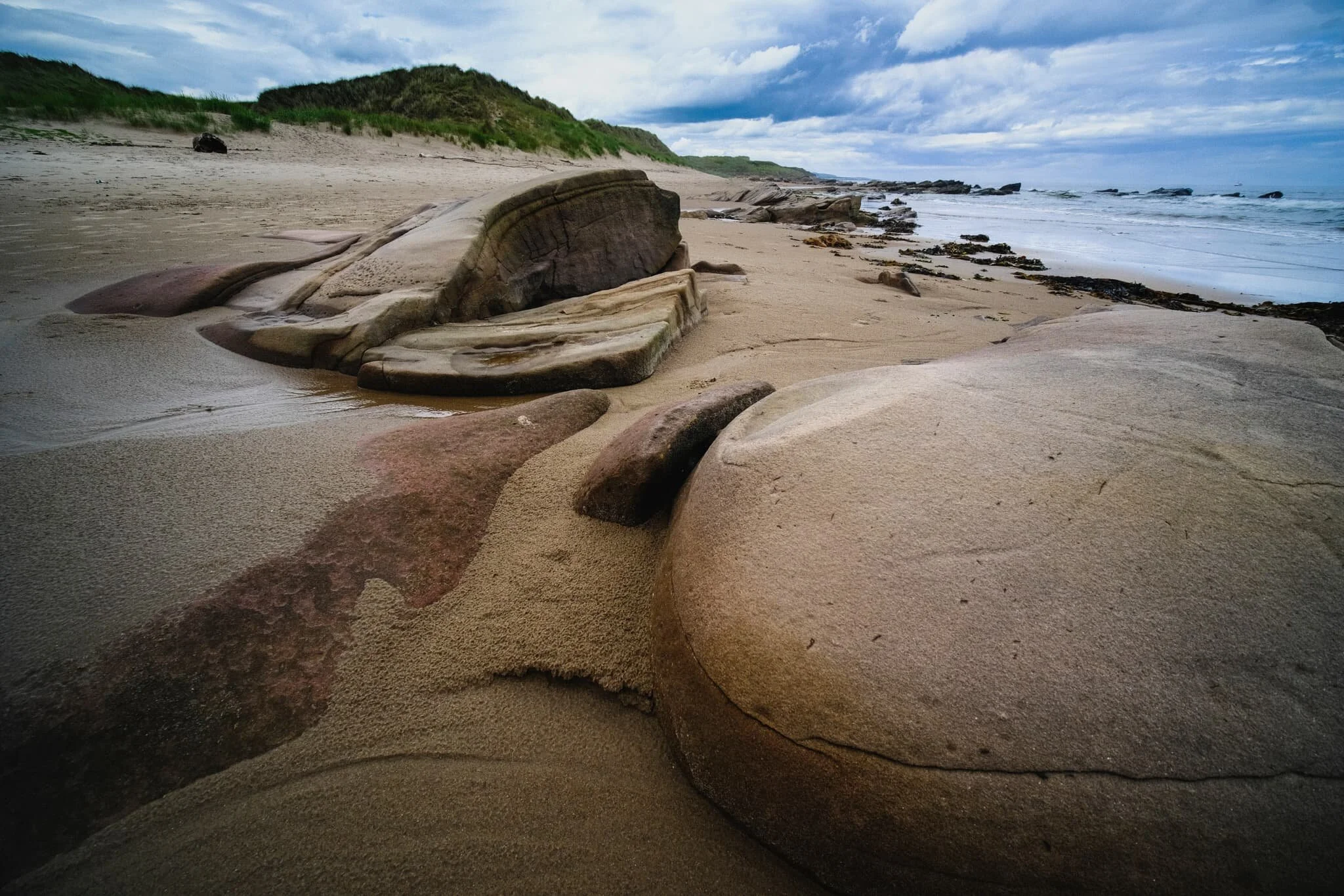
Thankfully, this was the correct decision. Not only did the rain fall as soon as we arrived at the pub (thank you, Lord Crewe Hotel), but the conditions at Cheswick Sands were blessedly dry. More than that, Cheswick Sands is beautiful. The area features extensive dunes, soft beaches, and fantastical sandstone formations to play around with photographically.
I made perhaps some of the finest seascape compositions I’ve ever done.
All photos shot on my Fujifilm X-T2 using my three prime lenses: a Samyang 35mm f/1.2, a Laowa 9mm f/2.8, and an adapted Pentax SMC 55mm f/2.0. All images were made 80% in-camera using a customised Velvia film simulation, with minor edits and corrections after in Lightroom and Affinity Photo.
An early start meant we were able to park freely in Bamburgh and wander around the village with few people around. Pretty much no matter where you are in Bamburgh, the castle is sure to dominate the skyline.
The grounds around Bamburgh Castle were looking particularly lush and verdant.
Not something I expected, or wanted, to see when clambering around Harkess Rocks on Bamburgh beach. A dead Northern Gannet (Morus bassanus). You tend to see these beautiful birds more around cliffs and isolated rocky islands, so I’m not sure why this one was found near the beach.
My first aim of the morning at Bamburgh beach was to head to Harkess Rocks, which separates Bamburgh beach from Budle Bay. Here one can find a painted deer. Is it prehistoric? A recent piece of art? No-one’s quite sure. One story says that it was painted because a white stag jumped into the sea to escape hunters. Another story reckons it was painted by Italian prisoners of war during World War 2.
Harkess Rocks and Blackrock Point features a prehistoric fault line and a confusing jumbled mass of ancient volcanic rock. Compositionally, I think this area is better to shoot when the tide is in, allowing the water to better separate the shapes of the rocks.
Above Harkess Rocks is Bamburgh Moor, where Lisabet alerted me to a field full of these beautiful flowers (Phacelia tanacetifolia or Purple Tansy). You can read about the farmers who manage this field and why they sow the flowers here.
You’ve gotta admit, it’s a pretty stunning scene.
More of the layering of the scene is involved in this composition as the day started to brighten up.
North of Bamburgh Lighthouse, around Blackrocks Point, we found this open rock pool surrounded by these tessellating structures of volcanic rock. Made for a lovely, if challenging, composition.
Back from the main rock pool, I spotted another smaller rock pool filled with vivid lime green sea moss. I lined up a composition to create a kind of Figure-of-8 shape in the middle of the frame, surrounded by the dark volcanic rocks of Blackrocks Point.
North west of Blackrocks Point and Bamburgh beach, the sands open out into Budle Bay and its vast expanse of golden sand.
One reason on this day not to venture into the sea for a paddle or a swim: jellyfish. No thanks.
A minimalistic composition involving the vast virgin sands of Budle Bay.
Heading back south towards Bamburgh, the day brightened up and people had arrived to soak up the sun. In the distance, you can make out one of the Farne Islands, an important wildlife habitat.
The hulking might of Bamburgh Castle, standing protectively over the coastline and sea.
At around midday the beach was quickly filling up with people. I nabbed this quick composition of Bamburgh Castle in the distance with the edge of Harkess Rocks closer to the viewer.
This was where we decided to exit the beach and devise an alternative plan to avoid the approaching storm. Foreboding indeed.
The approaching storm made for some dramatic clouds above Bamburgh Castle, though.
Seemingly oblivious to the approaching storm about to drench them in rain, a group of friends enjoy a game of croquet in the fields next to Bamburgh Castle.
Bamburgh’s a proper bonny village.
After escaping the rains falling over Bamburgh and inland Northumberland, we drove north to visit a relatively little-known beach called Cheswick Sands. I snapped the rather dramatic skyline from the car park. Good job we weren’t under that.
Access to Cheswick Sands involves clambering up and down the soft sands of Cheswick’s dunes. From the top of one, I made this composition of the undulating dunes, the North Sea, and the dark storm in the distance.
As we gently wandered north along the gloriously empty beach of Cheswick Sands, we came across a band of exposed sandstone known as Cheswick Black Rocks.
They featured some wonderfully sculptured and bizarre rock formations, shaped over the eons by wind and sea. I had lots of fun making compositions of them.
It’s not very often I get to keep my ultra-wide 9mm lens on and play around with strange rock shapes and near-far photographic compositions. Loads of fun!
Probably my favourite composition of the whole day.
The northernmost parts of Cheswick Black Rocks were still covered in slippery seaweed and moss, which made for great colours.
Sculpted rocks, sand dunes, the North Sea, and a stormy sky. Love it.
I managed to climb on top of some of the higher rocks to grab this more unusual curving shape, accentuated courtesy of my 9mm lens.
Another fantastical rock formation, seemingly made of “scales” of discs folding over each other.
Curving flowing lines and pure untouched sand with a dramatic sky above.
As the sun came out to play a bit more, I found this beautiful boulder that I had to make a composition of before we returned to the car.
Miles of rippled wet sand and a long pool reflecting the dramatic sky above. What a quality day.
St. Abbs Head, Scottish Borders, Scotland
I’m back from a week away! How’s everyone been?
I’m back from a week away! How’s everyone been?
Lisabet and I took a week’s summer break, based in a small farm cottage not too far from Berwick-upon-Tweed, Northumberland. We enjoyed lots of hiking this holiday, and as this is Northumberland and the Scottish Borders, that meant plenty of coastal action, beaches, cliffs, the lot.
First, welcome to St. Abb’s Head in the Scottish Borders. A 30-minute drive from Berwick-upon-Tweed in England, the coastline of the Scottish Borders can often be missed or ignored by the bigger pull of the likes of Edinburgh and East Lothian. However, the coastline and cliffs of St. Abb’s Head are world class and demand a solid exploration and inspection.
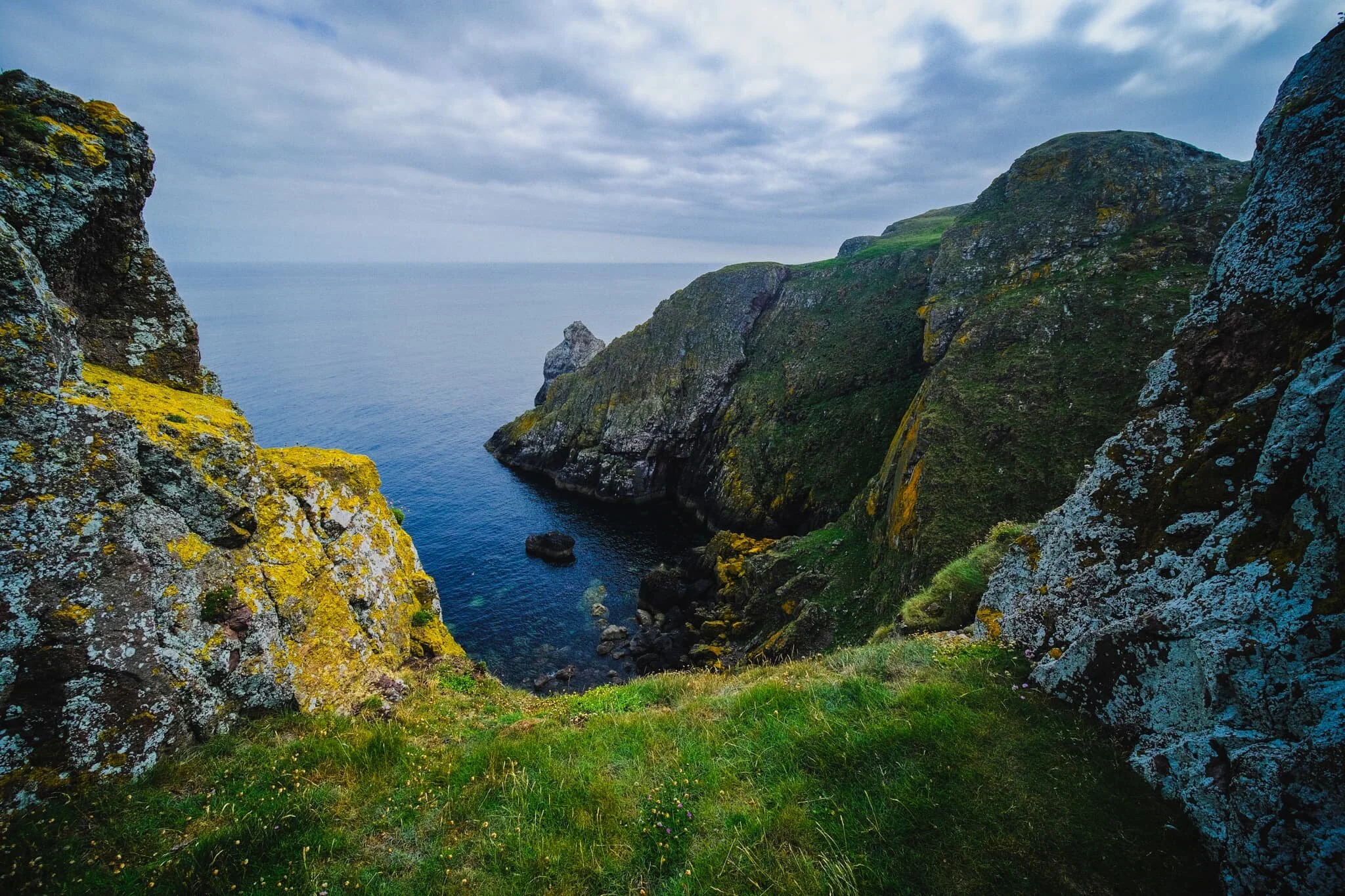
St. Abb’s Head is a headland of cliffs, steep gullies, and sea stacks lying north of the village of St. Abb’s. The rock here is of volcanic origin, compared to the surrounding area’s softer sandstone. With eons of pummelling from wind and sea, this has left a coastline of twisted and contorted rocks, sheer 200ft cliff faces, and isolated islands and sea stacks.
All of this also makes the area perfect for seabirds. St. Abb’s Head is home to a seabird colony of 60,000, essentially making the whole area a City of Birds. Here one can find guillemots, razorbills, kittiwakes, fulmars, shags, herring gulls, and puffins. At times, the noise from all the birds is deafening.
We could not have asked for better conditions to hike St. Abb’s Head. After days of either rain or sea haars, it was refreshing to have a clear atmosphere, soft summer light, and a gentle breeze.
Please enjoy my photos of some of Scotland’s most epic coastline.
Photos taken on my Fujifilm X-T2 using my three prime lenses: a Samyang 35mm f/1.2, a Laowa 9mm f/2.8, and an adapted Pentax SMC 55mm f/2.0 lenses. All images were made 80% in-camera using a customised Velvia film simulation, with minor edits afterwards in Lightroom and Affinity Photo.
Just up the road from the National Trust for Scotland car park, the land above St. Abb’s head is perfect for arable farming. This scene immediately put me in mind of the famous Windows XP wallpaper, so I made an attempt at a homage to that iconic image.
The footpath away from the village quickly gains height, and the views back to St. Abb’s immediately open up. The sun broke through the clouds briefly, highlighting the cliffs of the village and rendering this scene with an almost improbable painterly quality.
A more… unusual composition of the village. Here I nestled next to the cliff edge to get these flowers in the bottom of the photo, followed by the sheer cliff face known as White Heugh, then the village in the distance. I then waited for any of the sea birds to fly into view before pressing the shutter.
Although I’ve been to St. Abb’s Head a few times now, I’ve never visited in the peak of summer. What I didn’t expect was the sheer variety and colour of all the flora around the cliffs. Astounding! Here’s the view looking straight down from above Wuddy Rocks towards White Heugh cliff and the distant village of St. Abb’s.
Onward from Wuddy Rocks, we aim towards the main headland of St. Abb’s Head itself. The shadows of clouds glide across the golden farmland below.
At Horsecastle Bay, this scene presents itself to us. In fact, as it came into view, Lisabet heard me mutter, “Oh, fuck off!” Wildflowers adorn the cliff edge, framing the various rocks in the bay and the curious boot-shaped red sea stack.
Further around Horsecastle Bay, Lisabet follows a solitary spur, which slightly spooks the birds nesting below. A pick my composition and wait for all the elements to align.
The southeastern cliffs of St. Abb’s Head is known as Kirk Hill, and features a variety of geological “uncomformities”; that is, layers of rock from vastly different ages in history, lying next to each other.
As we climb up St. Abb’s Head, the lighthouse comes into view. We hang around the cliff edges above Clafferts Rock for some compositions involving the lighthouse.
Beyond the lighthouse, the cliffs get steeper and more vertical. Lisabet follows one spur alone. Click/tap the image for a bigger view; you may well be able to point out the hundreds of birds on the cliffs to the left.
I clambered down the cliffs beneath the lighthouse for a view looking back towards it.
It’s hard to do justice to the sheer scale of these cliffs and how far they drop to the North Sea below. Also, not pictured, is the deafening sound of thousands of seabirds shouting at each other.
The cliff edges were covered in a wide variety of summer flora.
Other hikers follow the cliff edge trail, and as I line up a composition of the cliffs of St. Abb’s Head, I deliberately include the people to help provide a sense of scale.
With my ultra-wide 9mm lens, I was able to capture images looking almost vertically down to the sea from the cliff edges as well as the horizon. A scene of pure drama, with sheer cliffs and finned sea stacks covered in guano.
Lisabet and I find a grassy opening framed by two towers that provides me with this wonderful composition of St. Abb’s Head and the North Sea beyond.
Further northeast along St. Abb’s Head, I follow a spur out near the ruins of St. Abb’s Nunnery, which enables me to view this open panorama of the sheer cliffs and St. Abb’s Lighthouse.
Lisabet and I get more adventurous and follow this particular spur all the way down and out towards the edge. I lay down and nab this composition looking back up to the sea stacks, the cliffs, and the lighthouse, all in one.
Towards West Hurker the geology gets even more insane, if that’s at all possible. In the distance we can start to see the cliffs of Uilystrand Brae.
The cliff edges here get more erratic, now featuring individual towers and pillars that provide small openings and sheer drops to the sea below.
Don’t look down…
Towards the edge of West Hurker, the northwestern part of St. Abb’s Head, the path becomes gentler as the cliffs of Uilystrand Brae grow in stature.
To get a better view of the Uilystrand Brae cliffs, we elect to follow the steep grassy path down to Pettico Wick Bay, with the views getting more epic along the way. Check out the wee little hikers in the bottom-left of the frame!
And there it is. Pettico Wick Bay and the twisted cliffs of Uilystrand Brae on a perfect summer’s day.