Lancaster Canal, Cumbria, Spring
Today was a little more low key.
Today was a little more low key.
The last time Lisabet and I walked the “Northern Reaches” of Lancaster Canal was back in May/June of 2020. You should check those posts out for more of the history of Lancaster Canal, with greater detail about the Northern Reaches.
After a day around Grizedale Forest, we felt a simple walk alongside some of the Northern Reaches of Lancaster Canal was in order. In particular, the section from Millness to Duke’s Bridge, with Farleton Knott in plain sight, is stupendously pretty. And the weather didn’t disappoint either.
All photos shot on my Fujifilm X-T2 using a Samyang 35mm f/1.2 lens with a Marumi Super DHG circular polariser attached. Developed using RNI’s Kodachrome film profiles.
If you ever want to take a boat to explore some of the abandoned Northern Reaches of Lancaster Canal, this is where you do it.
Glorious spring light bleeding through the trees. It’s lovely to see all the leaves on the trees starting to sprout.
Looking back the way we came.
Popping out of the more wooded section of Lancaster Canal reveals the unmistakeable presence of Farleton Knott (265 m/869 ft). Whilst certainly not a large hill, it is nevertheless a striking silhouette.
Closer to Duke’s Bridge, with some cyclists ahead enjoying the day.
Just… a lovely little scene.
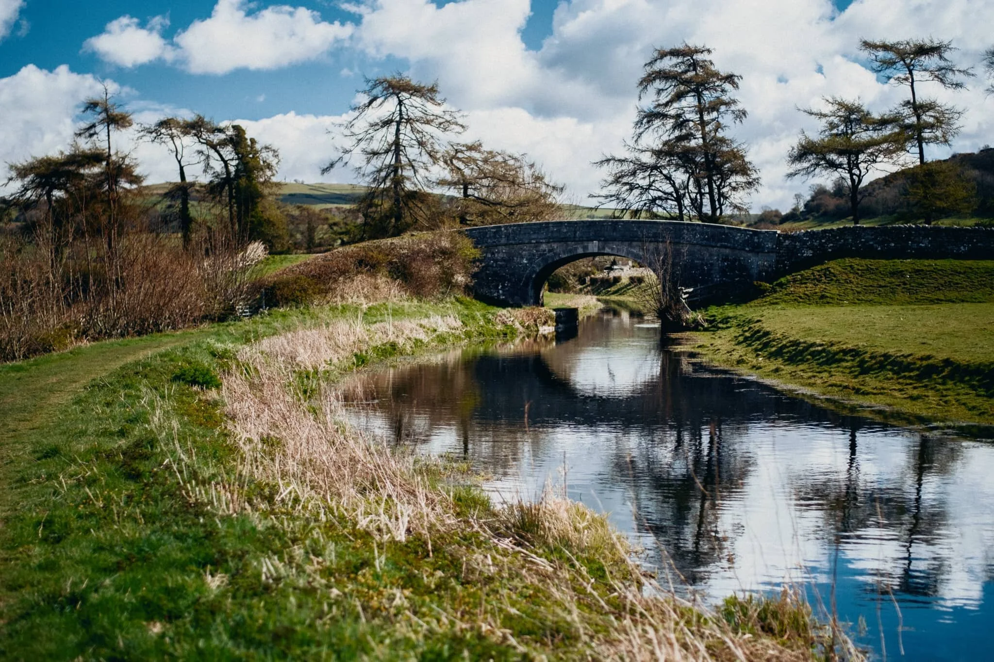
Farleton Turnpike Bridge (Nº 156) just before Duke’s Bridge, which signals the end of this section of the canal (and the path).
Hodgson’s Bridge, (Nº 157).
At Duke’s Bridge the canal opens out into a mooring/turn point area, allowing for some reflections of Farleton Knott.
Looking back all the way down the Canal path from near it’s terminus. Off-photo to my right, a pair of swans were busy building a rather comfortable-looking nest.
I can heartily recommend walking the Northern Reaches of Lancaster Canal for a non-taxing yet visually pleasing wander.

Part 2: Lancaster Canal’s “Northern Reaches”, Cumbria, Spring
The final stretch of Lancaster Canal.
The final stretch of Lancaster Canal.
In case you haven’t seen it you should check out my first photo blog about the Lancaster Canal, which contains the history of this iconic and important canal system.
The following day Lisabet and I decided to revisit the canal’s “Northern Reaches”, this time heading north from Millness Bridge (Nº 164) in Crooklands instead of south. This stretch is the final waterway of Lancaster Canal, which ends at Stainton somewhat abruptly. There are ambitions to re-water the canal for a quarter of a mile north of Stainton towards Kendal, and work has begun on repairing and upgrading Stainton Aqueduct after Storm Desmond wreaked havoc in December 2015.
All photos shot on a Fujifilm X-T2 with a 16–50mm f/3.5–5.6 lens using a customised Classic Chrome film simulation.
Looking back on Crooklands Bridge (Nº 166), which carries the B6385 over it. Another scorching hot day with barely any wind means very low water levels in the canal and pristine reflections.
Bulls and bullocks paddle in the waters of Lancaster Canal to cool down and have a sip.
Honestly, I were tempted to join them.
I kept waiting for this bull to look at me for this photo but it adamantly refused.
Not sure it’s possible to get a more bucolic scene of English rural idyll.
Old Hall Bridge (Nº 167) with almost perfect reflections; beyond you can just make out the slopes of Scout Hill (284 m/931 ft). On the banks before this bridge Lisabet and I were enthralled by a grey heron (Ardea cinerea), fishing in the waters of Lancaster Canal.
The end of Lancaster Canal at Stainton.
The next stretch of Lancaster Canal from Stainton, which has been relaid with lining and blocks. Not quite filled up yet, and of course it currently remains unconnected.
After Sellet Hall Bridge (Nº 173) the newly restored Lancaster Canal ends once again, totally dried up and reclaimed by nature.
Nature closing in on the 200-year old structures of Lancaster Canal.

Lancaster Canal’s “Northern Reaches”, Cumbria, Spring
Over the years I’ve learned that the UK’s canal system is fascinating.
Over the years I’ve learned that the UK’s canal system is fascinating.
Built primarily as a means to quicky transport raw materials and goods between major manufacturing towns and cities, these days the UK’s canals are largely used for leisure and tourism purposes.
Lancaster Canal was originally proposed in the mid-18th century as a way to link up the prosperous port of Lancaster with the growing port of Liverpool. Ships delivering goods between the Old and New Worlds (Europe and the Americas respectively) were getting bigger, and navigating the tricky Lune Estuary into Lancaster was becoming increasingly problematic.
In 1819 the new Lancaster Canal section between Preston and Kendal was completed, but never linked via the waterways towards Wigan where all the coal came from (a “temporary” tramroad was constructed that linked Preston to Walton Summit, 5-miles south of Preston, from which the canal continued to Wigan. Eventually the tramroad was made permanent). Lancaster Canal flourished, mostly transporting coal from the Wigan area northwards, and moving wool and limestone from Kendal southwards.
This domination ended with the advent of the railways, particularly the Lancaster–Carlisle line as it promised the transportation of goods beyond Kendal. By 1885 the Lancaster Canal Company ceased to exist and the railway line was bought by London & North Western Railway Company.
The railways themselves then came under threat with the advent of cars and roads. By 1944 canal traffic to Kendal ended, the section between Stainton and Kendal was gradually dewatered, and the last two miles of the canal in Kendal was filled in. During the 1960s the development of the M6 motorway north of Carnforth split the Northern Reaches of Lancaster Canal, which terminated Lancaster Canal at Tewitfield and left the remaining unlinked sections of the canal to be reclaimed by nature.
Lisabet and I recently explored a small section of the Northern Reaches of Lancaster Canal via its old towpath; from Crooklands at Millness Bridge to Duke’s Bridge right underneath the imposing stature of Farleton Fell. It’s fascinating to trace the old route of the canal, the places where it’s been cut off from the main canal system, and to observe the ways nature has been reclaiming the waterway.
All photos shot on a Fujifilm X-T2 with a 16–50mm f/3.5–5.6 lens, using a customised Classic Chrome film simulation.
Looking north along Lancaster Canal from Millness Bridge (Nº 164) in Crooklands. This is also where, once a month during the summer, you can take a guided narrowboat tour of these abandoned Northern Reaches of the old canal.
South from Millness Bridge the canal is lush with overhanging trees, grasses, and flowers of all sorts. You soon reach Seven Milestone Bridge (Nº 163), reflected here in the very dry canal. This bridge carries the A65 over it.
After passing Moss Side Culvert (Nº 162), which is where the A65 splits Lancaster Canal, the views start to open up. You can make out Dovehouses Bridge (Nº 161), but more obviously the looming shape of Farleton Fell (265 m/869 ft) comes into view.
Across the canal, farmers have made pleasing lines in the fields as they prepare hay.
On the banks around Dovehouses Bridge, daisies (Bellis perennis) grow in proliferation.
The canal was so low and still that it offered irresistible reflections of Farleton Fell.
Just beyond Hodgson’s Bridge (Nº 157). More reflections and Farleton Fell’s pointy knott becomes more apparent.
After Farleton Turnpike Bridge (Nº 156), and heading towards Duke’s Bridge (Nº 155). Two very shapely trees across the canal caught my eye.
What a scene. Farleton Knott above, cows and bulls grazing below, with lush vegetation everywhere. No wonder people want to restore this section of Lancaster Canal and link it back up. Imagine taking a narrowboat down here with these sorts of views…