
Grisedale, Lake District, Winter
Happy New Year, everyone! Here’s to a peaceful and gentler 2024.
Happy New Year, everyone! Here’s to a more peaceful and gentle 2024.
Though I’ve enjoyed time off work between Christmas and New Year, it’s not exactly been pleasant. Storm Gerrit washed across the UK, rendering most days miserably wet. There were even tornado warnings, largely unheard of in the UK.
On New Year’s Eve we learned that New Year’s Day promised much nicer conditions, and so we endeavoured to rise early and head into the Lake District for a solid yomp on the first day of 2024.
Conditions were certainly nicer, though you can never predict weather in the Lake District 100%. Hiking along the valley bottom of Grisedale towards the valley’s head, we were washed with wave after wave of fine drizzle. Thankfully, it never rained that hard, and in between the downpours we still managed to nab some glorious photos.
All photos taken on my Sony α7ii using my Pentax SMC 28mm F3.5 and Pentax SMC 55mm f2.0 prime lenses. RAWs developed in Lightroom using RNI Films’ Kodachrome film profiles, finalised in Photoshop.
Grisedale, Lake District, Winter by Ian Cylkowski is licensed under CC BY-NC-SA 4.0![]()
![]()
![]()
![]()
A sign of things to come. St. Sunday Crag (841 m/2,759 ft), rising above a sodden landscape with stormy clouds above.

Much of the first half of hiking into the valley comprised of dodging waves of drizzle. When one cleared up for long enough, I snuck this shot of Eagle Crag and Dollywaggon Pike (858 m/2,815 ft) battling with the low clouds.
Arriving closer to the turning point, we contemplated the condition of the trail on the other side of the valley. The hike in, on the south of the valley, is thankfully paved but had still been rendered in parts as a beck due to all the rain. I knew that the northern path back down the valley wasn’t in as good nick. So, from here, we turned back the same way we came in.
Thankfully, this was also when conditions started to clear up and the Helvellyn range of fells began to reveal themselves.
Eagle Crag with Nethermostcove Beck roaring down the fellside. A project was started in 2021 to return the valley’s main river, Grisedale Beck, back to its original “wiggly” form. To quote the Friends of the Ullswater Way: “As with many rivers in the UK, Grisedale Beck has historically been straightened and reinforced so that fields can be drained to improve grazing. This work was undertaken over 200 years ago and since then we have learned a lot about how straightened and reinforced rivers can negatively affect wildlife and increase flood risk. It should be noted that, despite the historic changes made to the river at the project site, this is still not particularly good grazing land, being very rough pasture and quite boggy in areas.”
Heading back down the valley, we kept turning back at the beautiful view at the head of Grisedale. Primarily to check on any incoming rain washing over the fells, but also to gawp at them. I enjoyed this composition as the trail seemingly leads across the image towards Nethermostcove Beck on the right. Pure mood.
One of the few pines left in the valley points a vibrant branch towards the beautifully cracked glacial erratic.
As the cloud cover finally starts to lift, Falcon Crag and Tarn Crag emerge from behind Dollywaggon Pike.
Light finally breaks through the clouds as we retreat further down the valley.
The beck streaming down from Blind Cove provides a nice leading line towards the vertical face of St. Sunday Crag.

The fells become obscured again. Another wave of rain heads towards us.
As another squall washes over us, I look across to the northern side of Grisedale and spot these bright becks cascading down the fellside. I very quickly nab a photo.
Soon, we near the foot of the valley and the rains were finally done for the afternoon. Look at that mountain backdrop.
Heading back towards the car, the hulking mound of Place Fell catches the warm winter light across its crags.
We elected for the scenic route back to Kendal, heading north out of Patterdale, through Matterdale, and onto the A65. That way we could turn off to head down St. John’s in the Vale and join the A591 back to Kendal. I kept my camera out, with the 55m attached to it, and grabbed this epic scene of Blencathra from the passenger’s side.
Down St. John’s in the Vale, I kept snapping happily, praying that at least one of the shots rendered sharp. Here, the deep cleft of Beckthorns Gill cuts into various crags of Clough Head.
Further south on the A591, near Thirlmere, Fisherplace Gill cuts a deep fissure within the crags of the Helvellyn massif. The farmhouses below look miniscule in comparison.
The distinctive shape of Browncove Crags, a subsidiary top of Helvellyn, with another deep gill caused by Helvellyn Gill.
Did you enjoy these photos?
Hayeswater, Lake District, Summer
Here’s one we’ve not been to in quite some time.
Here’s one we’ve not been to in quite some time.
After June’s dry conditions and soaring temperatures, July has been unseasonably cool, stormy, and wet.
A succession of wet weekends exhausted our patience, so Lisabet and I braved the Sunday and head into the Lake District.
The initial plan was for a valley bottom walk around Grisedale, one of my favourite places in all the Lake District. However, as we approached Brothers Water, Lisabet suggested revisiting Hayeswater instead, and I heartily agreed.
The last, and only, time hiked up to Hayeswater was way back in June 2013. A lot has changed in a decade. For a start, despite being 10-years older, we’re both fitter. The hike up to the former reservoir was considerably easier than we remembered it.
Our journey into Hartsop and up to Hayeswater was punctuated with frequent downpours and brief bursts of localised light. It made the going tough, but boy did it make for epic photos.
All photos taken on my Sony α7ii with a Sony FE 28–70mm f3.5–5.6 OSS zoom lens. RAWs were developed and edited using RNI Films’ Kodachrome film emulations.
Hayeswater, Lake District, Summer by Ian Cylkowski is licensed under CC BY-NC-SA 4.0![]()
![]()
![]()
![]()
From Cow Bridge car park, Hartsop Dodd (618 m/2,028 ft) towers over you as you head towards the sleepy little hamlet of Hartsop.
Looking up Patterdale, another squall drenches Place Fell.
After passing through Hartsop, we’re greeted with this view of Gray Crag (699 m/2,293 ft) whilst a small flock of Swaledales eagerly keep their distance from us.
Looking up Pasture Bottom towards Threshthwaite Cove as a small gap in the cloud cover lets some light in.
Beyond Hartsop, the trail quickly gains height, opening up the views back across Patterdale to the Fairfield and Helvellyn fells.
Another big squall soon drenches the Patterdale fells. It would be our turn soon.
With the steeper part of the trail behind us, a brief pause allows me to compose this image of Lisabet heading onwards with Sulphury Gill streaming down the fellside and The Knott (739 m/2,425 ft) rising sharply above.
The ascension ceases. At Hayeswater, I zoom in on the sheer face of High Street (828 m/2,717 ft) as clouds blow across.
Hayeswater is natural in origin, but was dammed in 1908 to supply water for Penrith. In 2005 it ceased to be used as a reservoir, and in the summer of 2014 United Utilities removed the dam, restoring the natural form of the tarn.
We watched as waves of clouds washed across the fell tops.
After stopping for lunch in the pouring rain, we started making our way back down the trail. 250 yds from the tarn, a new bridge crosses the gill that allowed for some nice compositions.
The waves of rain eased off and soon the immense views across Patterdale to the Helvellyn fells revealed themselves to us. To the bottom-right of the image you can see the old Filter House, now a private residence.
Glad to vaguely dry, I started to relax as we made our way down the trail. Beyond, the cloud cover lifted from the fells.
A break in the cloud illuminated the fells, if only for a moment, and I was able to capture this epic scene.
Nearing the valley bottom, the shoulder of Hartsop Dodd is bathed in glorious golden light.
A tighter, zoomed in composition involving a drystone wall, pasture field, and Raven Crag.
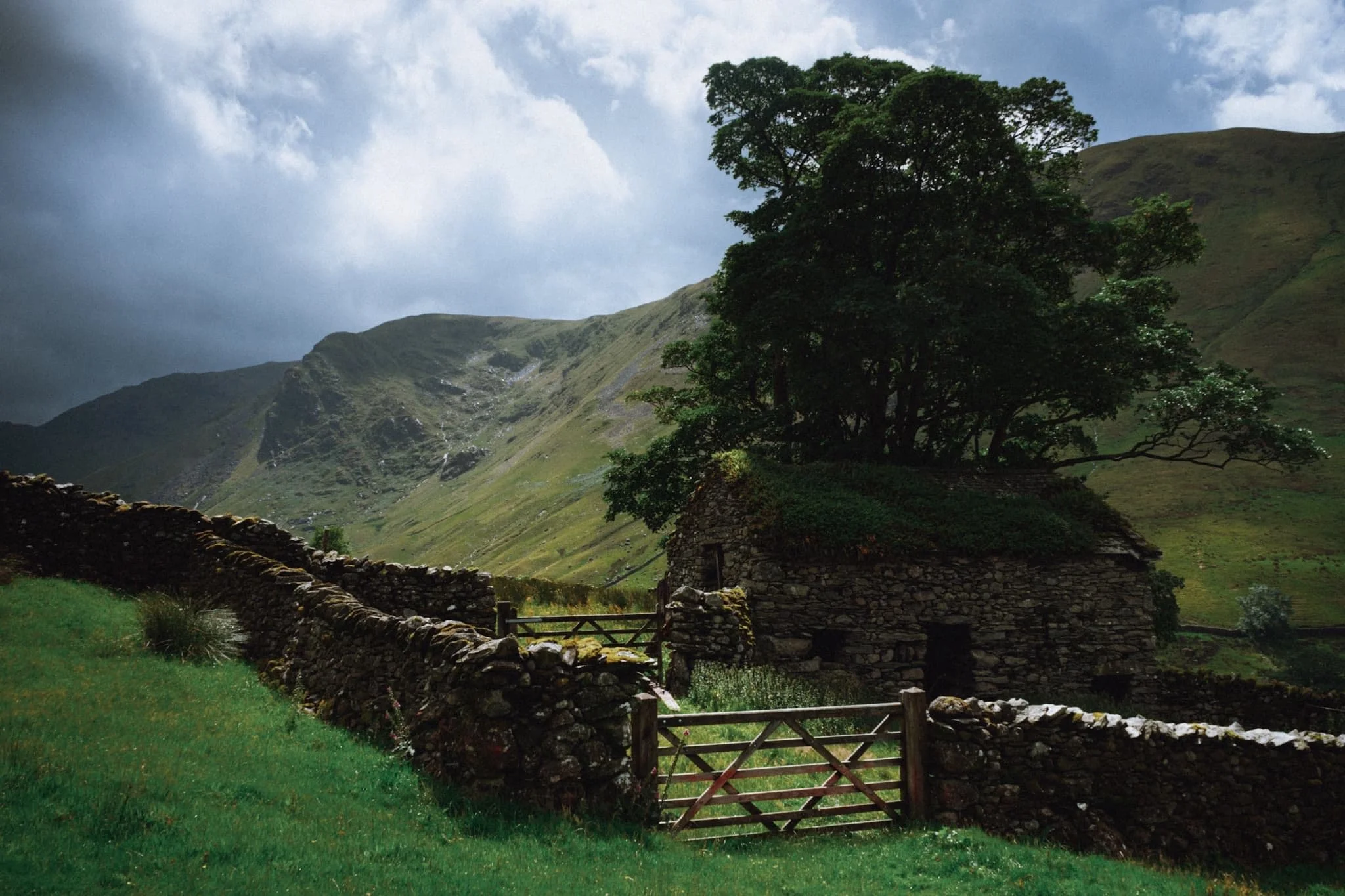
Beneath the towering form of Hartsop Dodd, this delightful barn captures our attention and imagination.
A beautiful scene of one of Hartsop’s houses with Hartsop Dodd looming above.
Perhaps the finest shot I got from the whole day. A dilapidated barn covered in a carpet of moss with a tree growing out of it. Beyond, a break in the clouds allows an intense burst of light to illuminate Raven Crag.
A true rural Lake District scene with the unmistakeable form of Hartsop Dodd keeping watch. The sky darkens as the clouds drop down and close in again.
We tried a different route back to the car park, passing by this gorgeous cottage as another wet squall starts to close the end of our walk.
Did you enjoy these photos?
Grisedale, Lake District, Summer
It was time to show Dad the glory of Grisedale.
It was time to show Dad the glory of Grisedale.
With the Queen’s Platinum Jubilee giving us two days holiday, Dad and I were able to spend some time together. We embarked on a hike up Grisedale, an offshoot of the main Patterdale valley near Ullswater. To my mind, Grisedale features one of the greatest valley sceneries in all of the Lake District.
I’ve attempted to show Dad Grisedale before, but the good ol’ Lake District rain has impeded us.
This time, we could not have asked for better conditions.
Please enjoy these glorious scenes. And, if you do like them, consider supporting me.
All photos taken on my Fujifilm X-T2 using my new Vivitar “Series 1” 28–105 mm f/2.8–3.8 lens. Developed in Lightroom, finished in Affinity Photo. Grisedale, Lake District, Summer © 2022 by Ian Cylkowski is licensed under CC BY-NC-SA 4.0.
Parking up at Patterdale’s King George V playing fields and pavilion, you are immediately greeted with the sheer face of Place Fell.
The lane leading to Grisedale is lined with rhododendron. I think this one may be Rhododendron fauriei.
The first inkling of what lies ahead. Black Crag, a sub-peak of St. Sunday Crag, soaring above us into the clear blue sky.
The road from Patterdale to Grisedale is quite the pull, but once you arrive at the valley… wow. One of the best valley backdrops in all of Lakeland.
There were a few hikers about, which is to be expected on a Bank Holiday. However, most of them were heading up the main trail to Helvellyn via Striding Edge. Not for us, thanks.
Testing out the capabilities of my Vivitar lens. This was shot at the full 105 mm zoom. A local farmer muck spreading across the valley bottom.
At Elmhow Farm, a composition catches my eye. A small barn fell into shadow, and I notice the similarity of its silhouette with the peak of Dollywaggon Pike above. A connecting shadow cast by the passing clouds completed this composition.
Beyond Elmhow, the valley starts to narrow as we approach the head. All along the way, Dollywaggon Pike watches over us.
I love watching clouds cast shapes and shadows on a fellside.
The cloud cover starts to thicken, casting deep shadows across the mountainous landscape. Glorious light conditions.
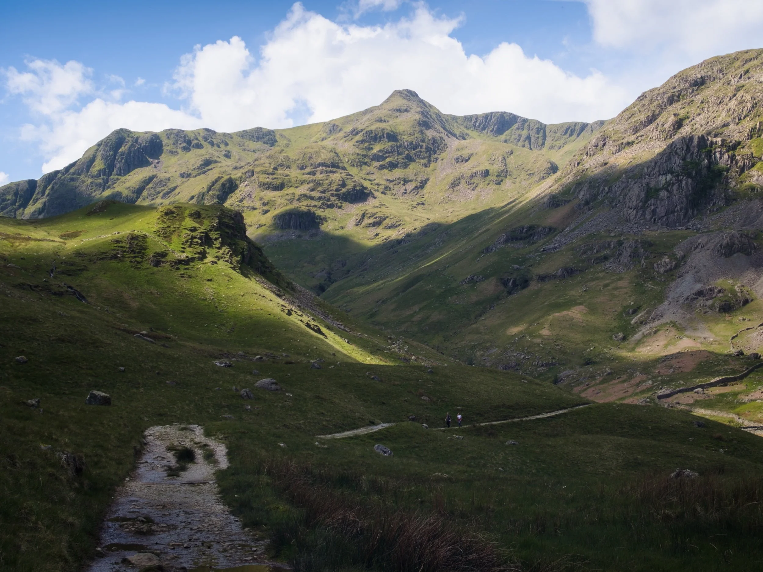
The trail narrows and winds as we approach the head of Grisedale. High above us are Falcon Crag and Tarn Crag, which drop down to Grisedale Tarn.
The path leads around the bottom of Post, on the left, a small crag that rise out of the valley floor. Above, Dollywaggon Pike is illuminated in between the racing clouds.
The small crag of Post, on the near left, enjoys a slither of summer light scanning along its surface. In the distant left are Falcon Crag and Tarn Crag, dead centre is Dollywaggon Pike, and to the right is Eagle Crag, a sub-peak of Nethermost Pike.
Immediately above us, on the southern side of the valley, is the sheer wall of St. Sunday Crag.
Dollywaggon Pike, punching the sky, cast in light and shadow. The joy of exploring the scenery at 105mm.
Another 105mm composition, zooming in on the crags of Eagle Crag as the light plays across them.
Looking back at our progress, down the length of Grisedale back towards Place Fell.
Crossing the boggy valley floor at Grisedale Beck, Dollywaggon Pike still demanding attention as its sunlit peak acts as a beacon.
The sheer wall of St. Sunday Crag, immediately above the Crossing Plantation.
Zooming on St. Sunday Crag and the shoulder of Post, criss-crossing each other in an interesting light-filled composition.
Place Fell’s bulk rises above the rolling valley bottom of Grisedale.
Our route back involved navigating the trail on the northern side of Grisedale. Here, erect ferns line the path, ready to bloom any day.
A person-sized glacial erratic, cleft in twain.
Another look back at Grisedale’s magnificent backdrop, with fellow hikers not far behind us.
A beautiful Herdwick ewe navigates the northern fellside amongst the fern.
The last of the year’s bluebells catching the light inside Broomhill Plantation.
My Dad after nabbing a shot of the frankly stunning scenery.
A Texel (?) yew enjoys a rest in the ferns.
Her lamb, following suit.
One last look back at Grisedale, now with more cloud cover making the sun beam shafts of light on the landscape. St. Sunday Crag to the left, Dollwaggon Pike and Nethermost Pike on the right.
Back on the valley floor, a Herdwick lamb stares at us quizzically.
Another lamb enjoys a mid-afternoon snooze in the summer sun.
Do you like these photos?
Deepdale, Lake District, Autumn
Grisdale keeps evading us.
Grisedale keeps evading us.
After meticulously scanning the weather forecasts and satellite radars, Dad and I embarked initially on a lovely hike up one of my favourite valleys: Grisedale.
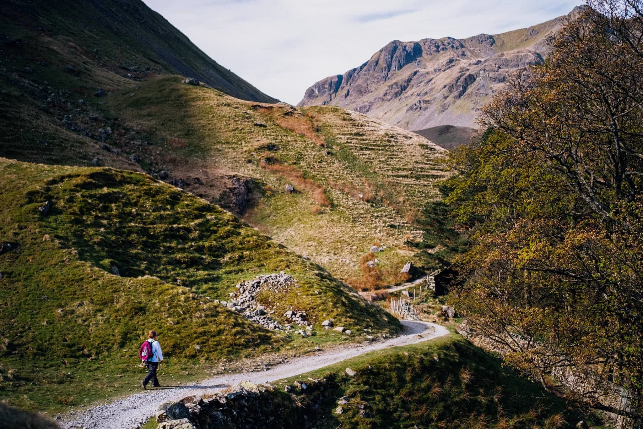
Last time rain fended us off. This time, a running/trials event blocked all the car parks in Patterdale and Glenridding. No matter, that’s why you should have a back up plan! Instead, we drove back towards Brothers Water and pulled up in a little-used layby. This was the start of the hike into Deepdale.
Although no less splendorous compared to Grisedale—featuring as it does the magnificent fell of Greenhow End at its head—it’s certainly not as good to walk. Large patches of Deepdale are often submerged in water and super boggy to boot. This means lots of bog-hopping.
Nevertheless, a crisp yet blowy autumnal day greeted us and Dad and I were treated to delicious light and wonderful colours.
All photos taken on my Fujifilm X-T2 using my three prime lenses: a Fujinon 23mm f/2.0, a Laowa 9mm f/2.8, and an adapted Pentax SMC 55mm f/2.0. Developed in Lightroom using my own Classic Chrome-based preset, finished in Affinity Photo.
An autumnal Arnison Crag (433 m/1,421 ft) above Greenbank Farm. And some actual blue skies!
Closer to the farm, my beloved Herdwick sheep come into view and the sun illuminates the scene.
Passing through the farm, we followed the track towards the valley. As the wind was blowing a hooley, the clouds above passed intermittently across the sun, allowing beautiful spotlighting of light.
As we pass Deepdale Hall, Latterhaw Crag below and the back of St. Sunday Crag (841 m/2,759 ft) come into view, drenched in golden autumnal light.
It’s always important to remember: don’t forget to look behind you. Otherwise I would’ve missed this lovely composition.
Aureate light highlights the boulders that line the cascades of Coldcove Gill.
Rowan berries provide a nice colour contrast against the icy cold waters of Coldcove Gill.
Behind us, the tops of Angletarn Pikes (567 m/1,860 ft) and Place Fell (657 m/2,156 ft) are treated to similarly gorgeous light.
Finally, the crown jewel of Deepdale comes into view: Greenhow End. A magnificent fist of a fell, here being treated to some delicious side lighting.
A clump of boulders blocking the trail provided a lovely scene with Greenhow End in the distance.
We’ve reached that stage of autumn all the bracken and fern turns a beautiful rusty shade.
My Dad, doing what he does best: awkwardly posing (love ya, really).

At various points, the “trail” gets close enough to Deepdale Beck, allowing for compositions such as this.
Dad and I spotted this boulder, and immediately made out the face-like structure in its forms. So, I lined up this composition involving Angletarn Pikes.
Dad, enjoying the light play above us.
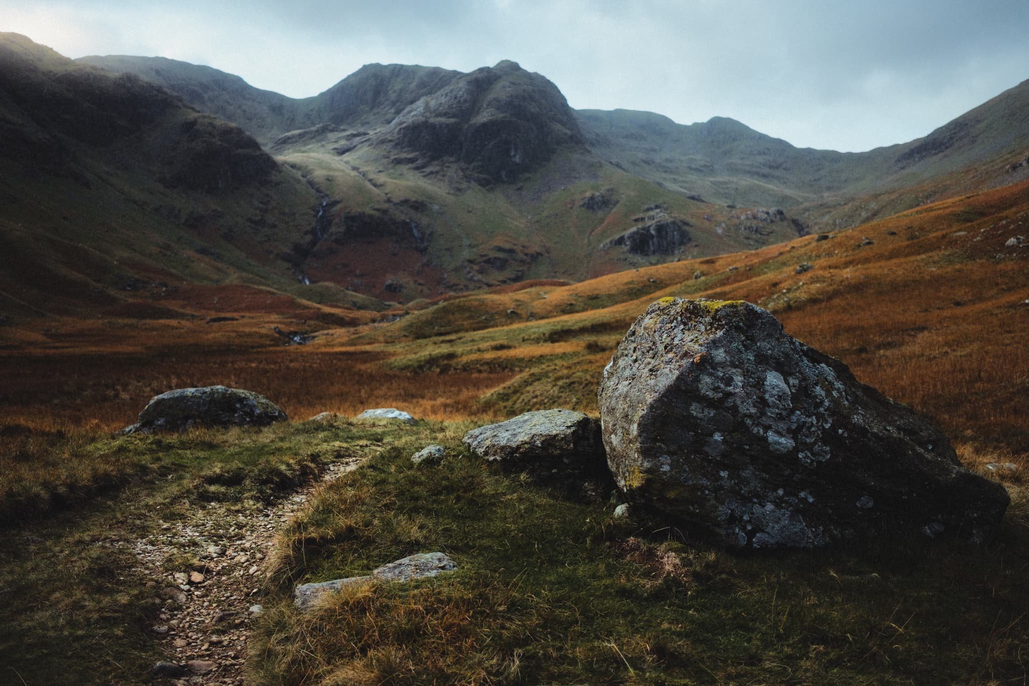
I spotted a cluster of boulders and glacial erratics, so I whipped out my ultra-wide lens to nab some more unusual and striking compositions.
I got real close to the glacial erratic, noting its wonderful lines, textures, and colours. I elected for a near-far ultra-wide composition, showcasing the strata in the boulder and Greenhow End above.
One of my favourite compositions from the whole hike. Just a perfect balance of light, contour, simplicity, and colour.
The head of Deepdale gets considerably boggier and impassable. That’s the point I usually turn back. Thankfully the views on the way back are no less splendid.
Place Fell providing the ultimate subject as the farm track makes a lovely leading line.
Sunlight bathes this field in warm light, leaving the fell in relative darkness. A circumstance of light and lines that I couldn’t ignore.
The farm track back to the main road. Almost impossibly idyllic.
Hunger was setting in. Time to grab some lunch.
After he was quite done grimacing at my camera, I managed to snap a nice warm candid photo of me Dad.
A lovely lunch was had at one of the Lake District’s most famous pubs: the Kirkstone Pass Inn, which has been in operation at the top of Kirkstone Pass (454 m/1,489 ft) since 1496 CE. What a lovely day out with Dad.
Grisedale, Lake District, Spring
Grisedale has to be in my top 3 favourite Lake District valleys.
Grisedale has to be in my top 3 favourite Lake District valleys.
I have a fairly troubled history with this place. The last time both Lisabet and I visited it was the middle of summer on a clear and hot day. We hiked all the way from the foot of the valley to Grisedale Tarn and back down. About 7 miles and 1,300 ft of ascent. In mid-20s heat, with no wind or clouds. Whilst being 23/24 stone. I suffered on that walk, and stumbled a lot on the way back down, which angered me.
Now I’m 7-stone lighter, much fitter, and mentally better. It was time to revisit this gorgeous valley, especially as it’s my birthday weekend (38 years on this planet, goodness).
Grisedale is a tributary valley of Patterdale, located in the north-eastern Lake District. Not to be confused with Grizedale Forest, which I’ve also been to. There’s quite a few Grisedale in Cumbria and North Yorkshire, and the etymology is the same: Old Norse gris meaning “pig” or “boar”, and Old Norse dalr meaning “valley”, giving us “valley of the boars”.
Most people access Grisedale for the purposes of summitting Helvellyn via Striding Edge, one of the “classic” Lakeland fells for thrill-seekers. But Grisedale itself has so much to offer, especially the views toward the head of the valley, featuring the craggy faces of Nethermost Pike (891 m/2,923 ft) and Dollywaggon Pike (858 m/2,815 ft), both ultimately subsidiary tops of Helvellyn itself (950 m/3,118 ft).
We arrived good and early, pre-8am. By the time we returned to the car, the car park was full as well as all the lay-bys and roads around Ullswater.
This summer is going to be insanely busy.
All photos shot on my Fujifilm X-T2 using my three prime lenses: a Samyang 35mm f/1.2, a Laowa 9mm f/2.8, and an adapted Pentax SMC 55mm f/2.0. Developed using RNI’s E100G film profile.
Lacing up.
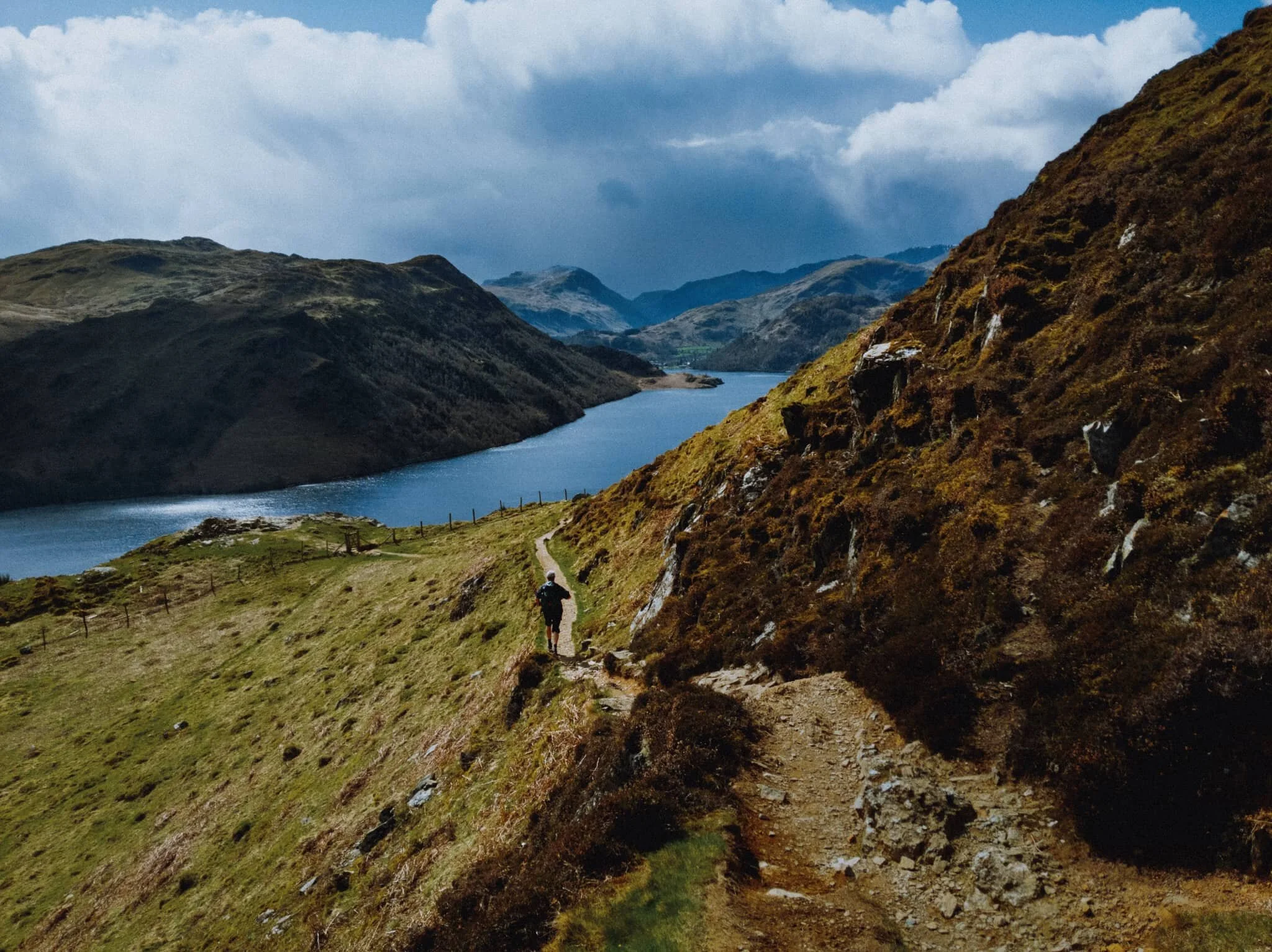
As soon as you pop out of Waterfall Woods, this is the view that greets you. Look at it. One of the best valley backdrops in all of Lakeland.
Lambing is in full flow in the Lake District now. There are plenty of Herdwicks in Patterdale, but in Grisedale there are more Swaledales.
Heading through Elmhow Plantation, when an old stone barn catches our eye for a composition. Especially lovely as we were sitting in the shadow and the morning sun was starting to catch the Helvellyn fells.
Heading through Crossing Plantation as we get closer to the head of Grisedale. Dollywaggon Pike glows like a beacon in the morning sun.
Exiting Crossing Plantation, with the sheer slopes of St Sunday Crag (841 m/2,759 ft) rising to our left.
My lovely Lisabet looking tiny underneath Dollywaggon Pike. The interesting little crag to the left underneath the fell is referred to on OS maps simply as “Post”. The more you know.
Looking back down Grisedale from whence we came. In the distance is the hulking mass of Place Fell (657 m/2,156 ft).
After reaching the head of Grisedale we crossed the tiny footbridge and started our way back down the north-eastern side of the valley. We stopped at Nethermostcove Beck to shoot some compositions looking towards Eagle Crag, as well as for refreshment.
One of the finest scenes in Grisedale.
As we neared the foot of Grisedale, several gates offered some lovely compositions involving the full expanse of the valley. St. Sunday Crag to the left, and the Helvellyn fells to the right.
An older gate, still in use.
Back at the valley bottom, near Waterfall Woods, I attach my 9mm ultra wide lens to use the trees as a frame for this scene.
Gowbarrow Fell, Lake District, Spring
Spring conditions are somewhat changeable at the moment.
Spring conditions are somewhat changeable at the moment.
Lisabet and I have been somewhat fortunate with this week-long extended Easter break. The first few days were relatively balmy for Cumbria, peaking at around 15°C. By Good Friday an “arctic blast” was arriving from the north, and temperatures quickly dropped by around 10°C or so. Despite the swing in climate conditions, the sky has remained consistently free of clouds.
This changed today and forecasts were warning of intermittent, and possibly heavy, snow squalls drifting through the county. We had originally planned for a hike around one of our favourite valleys, Mallerstang, but a sudden rush of inspiration from Lisabet meant heading up and over Kirkstone Pass towards Ullswater.
We quickly charted a route above the epic Aira Force, stopping to pay a quick visit to High Force, then out of the woods beyond High Cascades and up onto the shoulder of Gowbarrow Fell (481 m/1,578 ft). Then we would summit at Airy Crag, observe the Ullswater Way all the way around the eastern shoulder of the fell, and follow the track down the hill’s southern face, with sweeping views of Ullswater and the Helvellyn fells all the way.
What followed was an experience that ranked in our top three fell walks of all time. Absolutely glorious.
The only downside is that not long after starting the ascent up Gowbarrow Fell, my camera ran out of battery charge. I very much assumed I had enough charge, but temperatures barely above freezing point quickly saw to that. Thankfully my Google Pixel 3XL can shoot RAW files, which I relied on for the rest of the hike.
This is a fell we will definitely be revisiting, especially in late-summer when all the lovely pink heather will be blooming.
Photos shot on my Fujifilm X-T2, using a Samyang 35mm f/1.2 lens and Laowa 9mm f/2.8 lens, as well as my Google Pixel 3XL. Developed using RNI’s Kodachrome film profiles.
We parked in a National Trust lay-by not too far from Glencoyne Bay. I had a quick wander down towards the shore of Ullswater, knowing that at this time of year there’d be daffodils aplenty nearby. I weren’t wrong.
It was a gusty day, with the thermometer rarely reaching above 4°C. The wind chill factor pushed that number below freezing, feeling very raw on the face. Fortunately it made light conditions very changeable, which I always really enjoy. I adore watching the light scan and caress the fells.
In the woods of the Aira Force gorge, with one of my favourite trees in view. It puts me in mind of a pair of tights sagging down to the ankles.
Understandably the footpath around Aira Force woods is one way, which we made short work of. From the small stone bridge above the waterfall, my 9mm ultra wide lens allows an expansive and unique view of the drop down to the plunge pool and beyond. The usual viewing area below the waterfall is currently blocked off, as the National Trust who own the land here are currently working on a new and stronger viewing platform.
Beyond the main show that is Aira Force, one can take a quick detour off the main footpath to get this view of High Force.
This photo marks the change from my Fujifilm X-T2 to my Google Pixel 3XL. As we ascended up the western shoulder of Gowbarrow Fell, it became increasingly difficult to stop looking back at the evolving panorama behind us. Ullswater, and the Patterdale and Helvellyn fells.
Not only that, the higher we climbed the more we could see of the Northern Fells. Here I utilised the wooden marker as a compositional aid, pointing towards Blencathra (868 m/2,848 ft).
And eventually… summit! This is Airy Crag, the peak of Gowbarrow Fell. The views are expansive and exceptional; from here it’s easy to pick out not just the northern fells of the Lake District but also right across the Eden valley to the Northern Pennines. That also meant we could see the dark clouds steadily moving towards us.
The view from the summit towards the Helvellyn massif.
And the northern fells of Blencathra and Skiddaw.
As we started to round Gowbarrow’s eastern shoulder, the snow squalls came thick and fast.
But whenever a snow squall did pass, we were immediately rewarded with a burst of sun light.
Near Collier Hagg we found a nice crag to sit on and eat some lunch whilst admiring the views. Looking east across the Eden valley, it was easy to make out the North Pennines getting absolutely hammered by the rain and snow.
As we started to make our way towards the southern face of Gowbarrow, near the Memorial Seat, this view opened up that quite literally made me shout an expletive! A moment Lisabet and I will never forget.
I had to take a vertical composition as well.
We came off the Ullswater Way to admire the views down Ullswater towards the Patterdale and Helvellyn fells. Truly incredible scenes.
My poor Pixel’s attempt at a “zoom” photo. It’ll do.