Longridge Fell, Lancashire, Summer
Being in nature with your best bud is one of life’s greatest treasures.
Being in nature with your best bud is one of life’s greatest treasures.
I recently had the privilege of heading Down South (and by Down South, I mean, Preston) to spend a weekend with my best mate, Fie. With the prospect of a gloriously sunny British summer’s day ahead, we decided on a wee little excursion up Longridge Fell, east of Preston.
I’ve not been up Longridge in, perhaps, over a decade. The one and only time I hiked Longridge Fell was to capture the sunset from the summit with another good friend of mine, Bamber. This was very early on in my photography journey, so I was very unsteadily shooting HDR photos.
In fact, here’s the photo:
This was shot on the 7th August, 2012.
So yeah, it’s been nearly a decade.
Longridge Fell is the most southerly hill in England that has the word “fell” in its name. As you may have read previously in this blog, “fell” in Northern English dialects refers to a hill or a mountain, and can be traced from the Old Norse word fjall, which means “mountain”.
The fell’s name is quite literal as it truly is a long ridge, rising from the town of Longridge to its summit in 4.5 miles. Researching Longridge Fell caused me to learn a new word, which I’m always happy with: cuesta. This is a Spanish word and geographically refers to a hill or ridge with a gentle slope on one side, and a steep slope on t’other, which Longridge Fell definitely fits.
On this day, and for this walk, we started from Jeffrey Hill car park, which is already 200m-ish a.s.l. Only another 150m worth of ascension was needed to reach the summit.
The day was gloriously clear with nary a cloud in the sky. Like in Cumbria, Lancashire has seen barely a drop of rain in a good month or so. As a result, the fell—though normally boggy—was remarkably dry. This didn’t stop Fie from managing to sink one of her shoes into a surprise bog…
All photos shot on my Sony α7ii using my Sony FE 28–70mm f3.5–5.6 OSS zoom and Vivitar “Series 1” 70–210mm f2.8–4.0 zoom lenses. RAWs developed in Lightroom for iPad, then finalised in Affinity Photo 2 for iPad.
Longridge Fell, Lancashire, Summer by Ian Cylkowski is licensed under CC BY-NC-SA 4.0![]()
![]()
![]()
![]()
Across the rushes, grass, and valley, the nose of Totridge Fell (496 m/1,627 ft) on the southern edge of the Forest of Bowland becomes apparent.
As we level out near the summit Fie does her best meerkat impression, scoping out the view of the Ribble Valley.
Looking back west along the drystone wall. The clear atmosphere means we can easily pick out the city of Preston, and also Blackpool Tower 20-odd miles away.
Now equipped with my 70–210mm lens, I spot a composition of three solitary trees over the wall, seemingly standing guard over the Ribble Valley.
The moorland that makes up most of Longridge Fell allows for more minimalist landscape compositions, even in the peak of the summer day.
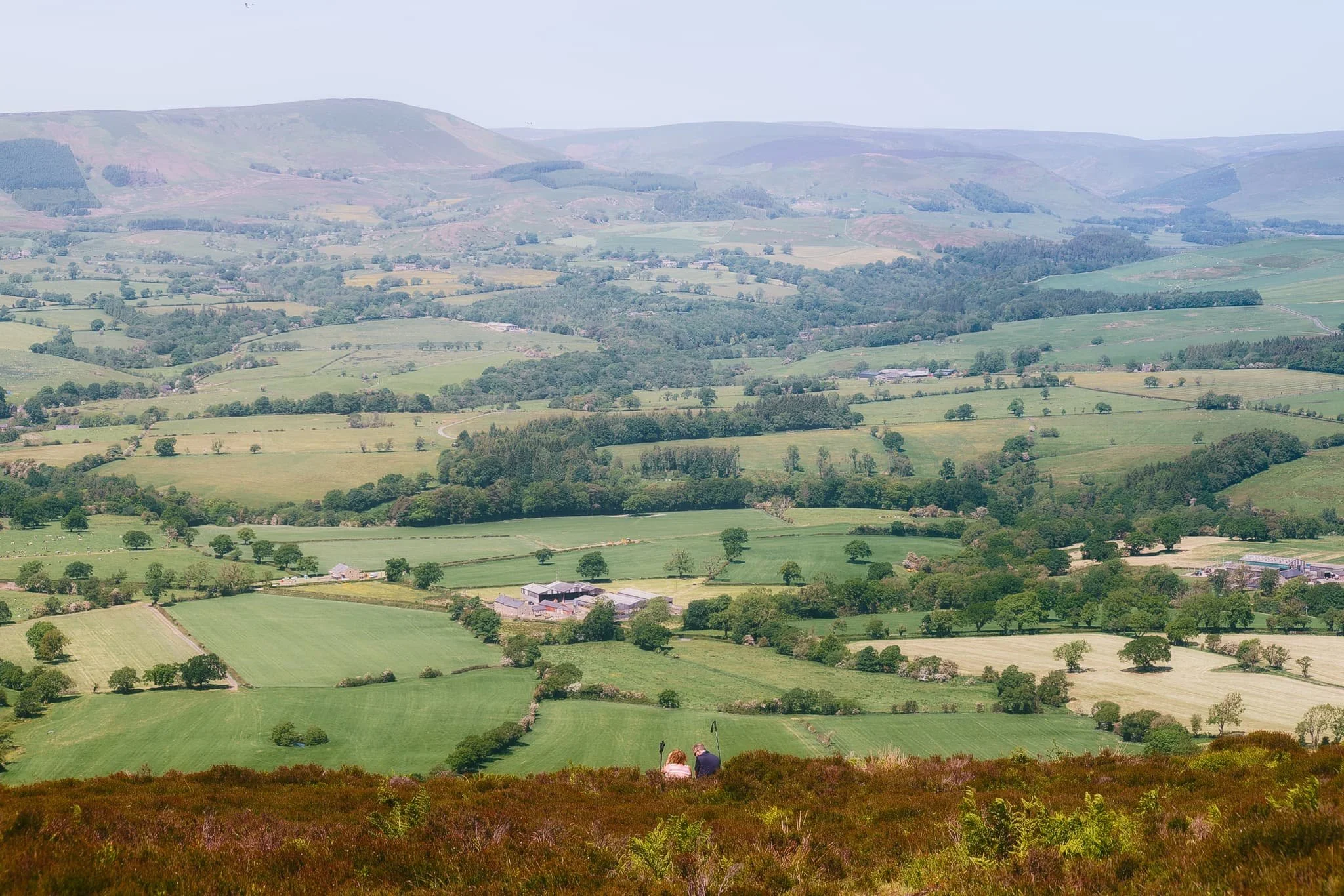
Looking down the sheer drop from near the summit, I spy a couple resting in the heather and bracken, enjoying the view across the valley towards the Forest of Bowland.
From the summit of Longridge Fell, I line up a composition looking east along the drystone wall and the forest edge.
Rather than simply heading back the way we came, we cut through the woodland on top of Longridge Fell. This allowed for some beautiful deep woodland compositions as the summer sun penetrated the trees in atmospheric ways.
One last look back at the summit, across all the ferns and picking out the solitary tree I shot earlier.
Did you enjoy these photos?

Brockholes Nature Reserve, Lancashire, Winter
Recently I had the joy and honour of staying over at my best friend’s place in Preston, Lancashire.
Recently I had the joy and honour of staying over at my best friend’s place in Preston, Lancashire.
I lived in Preston for many years, leaving in 2012 to move further up north in Kendal, Cumbria. As such, it’s been a decade since I’ve seen Preston. The city has changed a lot.
Well, let’s be accurate. Some parts of the city, around the thriving University of Central Lancashire, have changed dramatically as the University continues to steer the economic direction of the city. Other parts of the city, away from the University, have barely changed or—worse—have totally degraded.
Both scenarios were a shock to see.
To cap off a lovely weekend, my friend and I had a wee waltz around the Brockholes Nature Reserve, located on the eastern outskirts of Preston. The Nature Reserve is situated in the flood plains of the River Ribble, and features the UK’s first floating visitor centre. The weather was pretty terrible all weekend, but thankfully during our hike it brightened up enough to actually snap some photos, in between the furious downpours.
All photos shot on my Fujifilm X-T2 using my Fujinon 23mm f/2.0 and Laowa 9mm f/2.8 prime lenses. Developed in Lightroom and finished in Affinity Photo.
As we left the car park to walk the 3-mile “Discovery” trail around Brockholes, the clouds above did not promise settled conditions.
Thankfully, the unsettled conditions resulted in this wonderfully clear double rainbow arching over the ponds.
Nearing the floating visitor village the sun broke out behind us, illuminating the landscape whilst another dark squall approaches overhead.
The floating visitor village was designed by Adam Khan Architects, built by Price & Myers, and opened to the public in 2011. It houses shops, an exhibition area, an activity room for schools and community groups, a restaurant and a conference centre.
After knocking back an espresso with a flapjack, it was time for one last prowl around this magnificent feat of architecture.