Grisedale, Lake District, Summer
It was time to show Dad the glory of Grisedale.
It was time to show Dad the glory of Grisedale.
With the Queen’s Platinum Jubilee giving us two days holiday, Dad and I were able to spend some time together. We embarked on a hike up Grisedale, an offshoot of the main Patterdale valley near Ullswater. To my mind, Grisedale features one of the greatest valley sceneries in all of the Lake District.
I’ve attempted to show Dad Grisedale before, but the good ol’ Lake District rain has impeded us.
This time, we could not have asked for better conditions.
Please enjoy these glorious scenes. And, if you do like them, consider supporting me.
All photos taken on my Fujifilm X-T2 using my new Vivitar “Series 1” 28–105 mm f/2.8–3.8 lens. Developed in Lightroom, finished in Affinity Photo. Grisedale, Lake District, Summer © 2022 by Ian Cylkowski is licensed under CC BY-NC-SA 4.0.
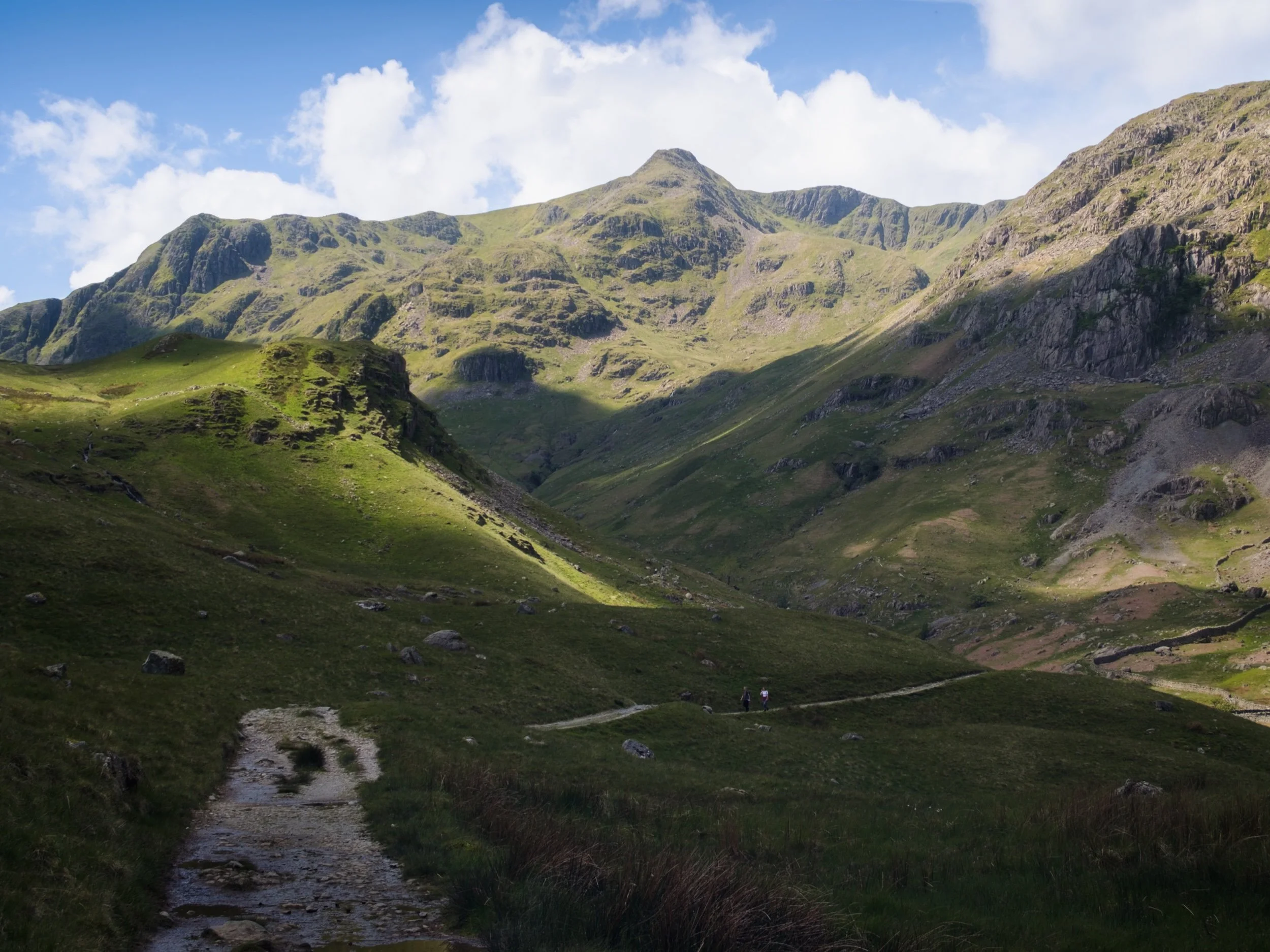
Parking up at Patterdale’s King George V playing fields and pavilion, you are immediately greeted with the sheer face of Place Fell.
The lane leading to Grisedale is lined with rhododendron. I think this one may be Rhododendron fauriei.
The first inkling of what lies ahead. Black Crag, a sub-peak of St. Sunday Crag, soaring above us into the clear blue sky.
The road from Patterdale to Grisedale is quite the pull, but once you arrive at the valley… wow. One of the best valley backdrops in all of Lakeland.
There were a few hikers about, which is to be expected on a Bank Holiday. However, most of them were heading up the main trail to Helvellyn via Striding Edge. Not for us, thanks.
Testing out the capabilities of my Vivitar lens. This was shot at the full 105 mm zoom. A local farmer muck spreading across the valley bottom.
At Elmhow Farm, a composition catches my eye. A small barn fell into shadow, and I notice the similarity of its silhouette with the peak of Dollywaggon Pike above. A connecting shadow cast by the passing clouds completed this composition.
Beyond Elmhow, the valley starts to narrow as we approach the head. All along the way, Dollywaggon Pike watches over us.
I love watching clouds cast shapes and shadows on a fellside.
The cloud cover starts to thicken, casting deep shadows across the mountainous landscape. Glorious light conditions.
The trail narrows and winds as we approach the head of Grisedale. High above us are Falcon Crag and Tarn Crag, which drop down to Grisedale Tarn.
The path leads around the bottom of Post, on the left, a small crag that rise out of the valley floor. Above, Dollywaggon Pike is illuminated in between the racing clouds.
The small crag of Post, on the near left, enjoys a slither of summer light scanning along its surface. In the distant left are Falcon Crag and Tarn Crag, dead centre is Dollywaggon Pike, and to the right is Eagle Crag, a sub-peak of Nethermost Pike.
Immediately above us, on the southern side of the valley, is the sheer wall of St. Sunday Crag.
Dollywaggon Pike, punching the sky, cast in light and shadow. The joy of exploring the scenery at 105mm.
Another 105mm composition, zooming in on the crags of Eagle Crag as the light plays across them.
Looking back at our progress, down the length of Grisedale back towards Place Fell.
Crossing the boggy valley floor at Grisedale Beck, Dollywaggon Pike still demanding attention as its sunlit peak acts as a beacon.
The sheer wall of St. Sunday Crag, immediately above the Crossing Plantation.
Zooming on St. Sunday Crag and the shoulder of Post, criss-crossing each other in an interesting light-filled composition.
Place Fell’s bulk rises above the rolling valley bottom of Grisedale.
Our route back involved navigating the trail on the northern side of Grisedale. Here, erect ferns line the path, ready to bloom any day.
A person-sized glacial erratic, cleft in twain.
Another look back at Grisedale’s magnificent backdrop, with fellow hikers not far behind us.
A beautiful Herdwick ewe navigates the northern fellside amongst the fern.
The last of the year’s bluebells catching the light inside Broomhill Plantation.
My Dad after nabbing a shot of the frankly stunning scenery.
A Texel (?) yew enjoys a rest in the ferns.
Her lamb, following suit.
One last look back at Grisedale, now with more cloud cover making the sun beam shafts of light on the landscape. St. Sunday Crag to the left, Dollwaggon Pike and Nethermost Pike on the right.
Back on the valley floor, a Herdwick lamb stares at us quizzically.
Another lamb enjoys a mid-afternoon snooze in the summer sun.
Do you like these photos?

Kirkby Lonsdale, Cumbria, Spring
Cumbria’s got super cold again after last weekend’s bizarre heatwave.
Cumbria’s got super cold again after last weekend’s bizarre heatwave.
Following the weekend’s temperatures pushing 20ºC, Monday onwards saw conditions plunge back down to freezing point with fresh snow falling on the fells. Thankfully, as the week progressed, the atmosphere cleared up and blue skies have been a regular feature, but temperatures are still barely reaching 10ºC.
Yesterday, after a morning of Life Admin, Lisabet had a long-awaited hair appointment at the newly established Wilderness Hair Lune Valley at Kirkby Lonsdale. Whilst she was enjoying having her glorious curls revived, I enjoy the glorious spring day in this ancient and bonny town.
All photos shot on my Fujifilm X-T2 using my three prime lenses: a Fujinon 23mm f/2.0, a Laowa 9mm f/2.8, and an adapted Pentax SMC 55mm f/2.0. All images made 80% in-camera using the standard Provia profile, finalised afterwards in Affinity Photo on my iPad.
The site of the old Swine Market before you head down Mill Brow.
Heading down Mill Brow, an almost timeless scene.

The Old Manor House, largely built in the 1700s, though some surviving parts of the building are even older.
From the bottom of Mill Brow I followed the River Lune all the way to Devil’s Bridge. Here, limestone formations are abundant and I had fun arranging compositions involving these rocks and the formidable Devil’s Bridge.
On top of Devil’s Bridge a clear is offered to Stanley Bridge, which carries the A65 over the River Lune. Below, some folk play around the limestone formations alongside the river.
People checking out the views from Devil’s Bridge and helpfully providing my photo a sense of scale.
Always a good view from the top of Devil’s Bridge.
Heading back into town, I can never resist a shot of this majestic house covered in ivy.
On Market Square in the middle of Kirkby Lonsdale sits the former Trustees Savings Bank, built in the middle of the 19th-century. It’s now a private abode.
St. Mary’s Church, one of the oldest buildings in Kirkby Lonsdale. Parts of it date back to Norman times.
And, at this time of year, the cemetery grounds of St. Mary’s are covered in a variety of daffodils.
Just beyond the church is a short path to Ruskin’s View. Described by 19th century art critic, social theorist, painter and poet John Ruskin thus: “I do not know in all my country, still less in France or Italy, a place more naturally divine.”
Zooming in on the Barbondale fells and the heavy clouds looming above.
From Ruskin’s View, I navigated back to the town centre and up to nab one of my favourite views in all of Kirkby Lonsdale: the view down Mitchelgate with Gragareth in the distance.

Kendal (Post-Eunice), Cumbria, Winter
The day after Storm Eunice.
The day after Storm Eunice.
Evenings and weekends have been frustratingly wet and stormy in February, which has meant that I’ve not been able to get out into nature as much as I’d like. This culminated in the week commencing 14th February, which saw two named storms passing over the British Isles: Storm Dudley and Storm Eunice.
Storm Dudley struck first, from Wednesday 16th to Thursday 17th. It brought 80 mph winds and heavy rain to Wales and parts of Northern England and Scotland. Following Dudley, Storm Eunice arrived Friday 18th to Saturday 19th, with even stronger winds of up to 122 mph, and a rare Red Alert (danger to life) issued for the South West and South East of England. Videos across social media soon emerged of trees being ripped up from their long-held roots, power lines collapsing, wind turbines disintegrating, and even the O2 Arena having its roof shredded apart. Unfortunately, lives were lost, too.
This 2021–2022 storm season has reportedly seen more than 8 million trees destroyed.
By Saturday afternoon conditions started to calm down once more, and the sun soon came out. So, armed with my camera, I gingerly ventured out for a hike around my town, Kendal, to get some high vantage points and survey the damage.
All photos taken on my Fujifilm X-T2 with a Fujinon 23mm f/2.0 prime lens. Developed in Lightroom and finished in Affinity Photo.
It was nice to actually see the sun come out for once.
I decided to head up onto Castle Howe, the site of Kendal’s first castle. To do that, you need to turn onto Allhallows Lane then up one of Kendal’s steepest roads, Beast Banks.
Even following two life-threatening storms, people are still more than ready to head out for a spot of retail therapy.
About a ⅓ of the way of Beast Banks you can exit onto Garth Head, an ancient medieval lane connecting two steep streets, Beast Banks and Captain French Lane. It’s technically an unclassified highway—the U752—making its upkeep the responsibility of Cumbria County Council.
About halfway along Garth Heads a couple of footpaths branch off and head up the fellside. This is the way to Castle Howe, the site of Kendal’s first castle. Nowt remains of the castle now except an obelisk that marks the castle’s original location. The castle was built somewhere around the end of the 11th century or turn of the 12th century.

The obelisk that marks the site of Kendal’s first castle, Castle Howe.
What the land around Castle Howe does offer is a fantastic view across Kendal town all the way to Benson Knott and the Whinfell fells.
One of my favourite lanes in Kendal, and certainly one of the steepest.
From Low Fellside the view spreads out more. The Whinfell fells and the Howgills are covered in a fresh coating of snow.

Above Maudes Meadow Residential Care Home, the rabbits were happily munching and frolicking on the common.
Storm Arwen destroyed many trees around Maudes Meadow. Thankfully, Dudley and Eunice didn’t add to the casualty list.
The River Kent, too, appears to have returned to normal levels.

Brockholes Nature Reserve, Lancashire, Winter
Recently I had the joy and honour of staying over at my best friend’s place in Preston, Lancashire.
Recently I had the joy and honour of staying over at my best friend’s place in Preston, Lancashire.
I lived in Preston for many years, leaving in 2012 to move further up north in Kendal, Cumbria. As such, it’s been a decade since I’ve seen Preston. The city has changed a lot.
Well, let’s be accurate. Some parts of the city, around the thriving University of Central Lancashire, have changed dramatically as the University continues to steer the economic direction of the city. Other parts of the city, away from the University, have barely changed or—worse—have totally degraded.
Both scenarios were a shock to see.
To cap off a lovely weekend, my friend and I had a wee waltz around the Brockholes Nature Reserve, located on the eastern outskirts of Preston. The Nature Reserve is situated in the flood plains of the River Ribble, and features the UK’s first floating visitor centre. The weather was pretty terrible all weekend, but thankfully during our hike it brightened up enough to actually snap some photos, in between the furious downpours.
All photos shot on my Fujifilm X-T2 using my Fujinon 23mm f/2.0 and Laowa 9mm f/2.8 prime lenses. Developed in Lightroom and finished in Affinity Photo.
As we left the car park to walk the 3-mile “Discovery” trail around Brockholes, the clouds above did not promise settled conditions.
Thankfully, the unsettled conditions resulted in this wonderfully clear double rainbow arching over the ponds.
Nearing the floating visitor village the sun broke out behind us, illuminating the landscape whilst another dark squall approaches overhead.
The floating visitor village was designed by Adam Khan Architects, built by Price & Myers, and opened to the public in 2011. It houses shops, an exhibition area, an activity room for schools and community groups, a restaurant and a conference centre.
After knocking back an espresso with a flapjack, it was time for one last prowl around this magnificent feat of architecture.
Crina Bottom, Yorkshire Dales, Winter
Temperatures are still down but conditions are rather contentious at the moment.
Temperatures are still down but conditions are rather contentious at the moment.
That didn’t stop us from throwing caution to the bitterly cold wind! After examining my 90 million weather apps plus satellite radars, it looked to me that the further east we went, the better our chances for drier conditions.
To the Yorkshire Dales!
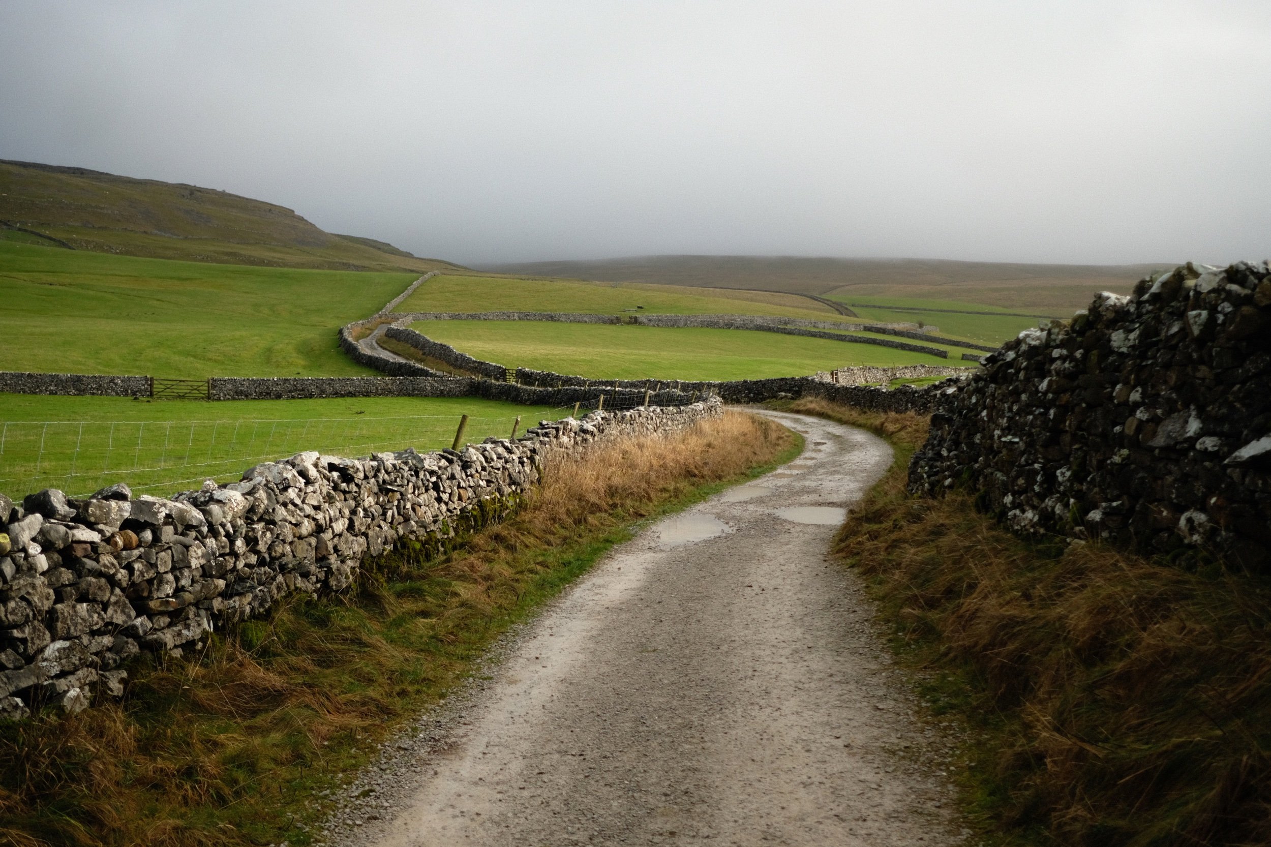
We settled on a hike up to Crina Bottom from Ingleton. We did plan on an additional hike from Horton-in-Ribblesdale to Hull Pot, but we unfortunately ran out of time. Nevertheless, Crina Bottom is lovely. It’s famed for its wonderful view of Ingleborough right above the farmstead (a shot of which you can see here). Unfortunately for us on this day, the cloud base level wasn’t due to lift anywhere above 500–600m, and Ingleborough is 726 m high.
Nevertheless, the low winter light was beautiful, casting isolated golden light across the landscape, drawing long shadows, and the low cloud level made for more minimalist landscape compositions.
All photos shot on my Fujifilm X-T2 using my Fujinon 23mm f/2.0 prime lens. Images were made 95% in-camera, with a final curve adjustment in Pixelmator Photo and framing in Darkroom.
We found a spare lay-by off the Ingleton–Hawes road, and already the light was looking gorgeous.
There’s a sparseness to a winter landscape that’s dramatic and beautiful.
It’s only 2.5 miles from the start of this track, known as Fell Lane, to the mountain that is Ingleborough. As such, it’s rather steep in places.
Beautiful golden light greets us as we enter the high-walled portion of Fell Lane.
Across the valley, Twistleton Scar gets drenched in light. Chunks of the drystone wall are still collapsed after Storm Arwen.
Around this part of the track you’d normally expect to see the shoulders of Ingleborough. Not today.
Looking across the fields to the winding walls that guide Fell Lane.
Over the fields towards the Aire Gap and beyond to the Forest of Bowland, the clouds race across the sky and the sun punches through where it can.
Crina Bottom, a remote farmstead that was fairly recently on sale. I think it’s been purchased now. No doubt it will see lots of hikers who use this bridleway to ascend Ingleborough.
Just imagine a giant flat-topped mountain framed in between those trees…
The last time we hiked up to Crina Bottom was August 2017, when I was shooting with my Sigma dp0. Definitely a different world in the winter.
We decided there wasn’t really any point attempting an impromptu hike up to Ingleborough, given that it was completely engulfed in clouds, so we made our merry way back down Fell Lane.
Random bit of fleece, probably from a Swaledale sheep, snagged in the barbed wire.
The long lonnin (lane) back down to Ingleton.
The shadow of Twistleton Scar makes an appearance as storm approaches us from across the Forest of Bowland.
Beautiful Ingleton lay before us near the bottom of Fell Lane. Hmm… a flapjack sounds good about now…
We decided on a wee extra wander into Ingleton town proper to procure a few groceries from the Co-op before hiking back up to the Ingleton–Hawes Road. Ingleton is in a wonderful setting.

Kirkoswald, Cumbria, Winter
Welcome to the ancient village of Kirkoswald.
Welcome to the ancient village of Kirkoswald.
The day ahead looked to be rather changeable, with unpredictable downpours combined with gusty winds. Our best bet was to head to Northern Cumbria. So why not spend a day with Dad?
We all ventured to Kirkoswald for a gentle stroll around the area. The village is timeworn, with many buildings still standing since the 1600s and 1700s. Even older—to the south of the village—is St. Oswald’s Church, with parts of it dating back to the 12th century. The church is, in fact, where the village gets its name: “Kirk” is the Old Norse word for “church”. It is thought that the body of Saint Oswald, King of Northumbria, was taken through the village.
Southwest of the village is Eden Bridge, a beautiful red sandstone construction. It dates from 1762, with repairs made in the 19th and 20th centuries.
Thankfully the day was largely cooperative, weather-wise, and we all enjoyed some lovely photography walking around this ancient parish.
All photos shot on my Fujifilm X-T2 using my three prime lenses: a Fujinon 23mm f/2.0, a Laowa 9mm f/2.8, and an adapted Pentax SMC 55mm f/2.0. All images 95% made in-camera using Øyvind Nordhagen’s Modern Documentary Fujifilm recipe, with cropping and framing in Pixelmator and Darkroom.
My Dad’s lovely little farm cottage, in the middle of nowhere of Northern Cumbria.
The road that passes by Dad’s cottage.
Dad set up a load of bird feeders outside the cottage, home to many species that he’s always happy to take photos of.
We parked at a small car park just before the Lazonby Eden Bridge. This signalled the start of our walk into Kirkoswald. The River Eden was rather high and fast.
On the Kirkoswald side of the main bridge that spans the River Eden are these “dry arches” that were, nevertheless, flooded.
She’s a beaut of an 18th century bridge.
I whipped on my 9mm ultra wide lens to capture the whole span of the bridge as well as the lovely cloud textures that were forming.
One last look back along the entire span of the bridge before carrying on towards Kirkoswald.
Evidence of Storm Arwen’s vengeance on trees across the UK.
We took the permissive footpath from Eden Bridge into Kirkoswald, then through the church gate to follow the old cobbled path towards St. Oswald’s Church.
The church is in a beautiful setting.
There she is, St. Oswald’s Church. The building’s unique in having a 19th-century bell tower on top of a hill 200 yards from the church itself.
The main entrance to the church. Historic England specifies this timber frame thus: “North timber-framed gabled porch of c1523”. So 500-years old.
Small, and old, but humble.
People are still buried in this church’s graveyard. I spotted a gravestone for January 2021. I’m sure there are conditions/restrictions that need to be satisfied for burial here.
Love the wrought iron works around the churchyard.
A rather grand entrance to an estate of some sort.
Crossing over the small bridge that spans Raven Beck. Ancient red sandstone buildings everywhere.
Not sure what these folk were doing along the shores of the beck… but I had to snap them.
One of many buildings in Kirkoswald dating from the 18th century. This one’s datestone reads 1713.
The Crown Inn, still very much in operation. It’s an old coaching inn, again from the 18th century.
On t’other side of t’road, Lisabet inspects the menu for the Featherston Arms.
Love old buildings that are wrapped in branches and vines.
Victorian-era road signage, which still references Cumberland County Council.
Out of the top of Kirkoswald, the views across the Eden Valley are extensive.
The village square. Kirkoswald gained a Market Charter in the 13th century, and hosted markets at the village square for centuries. This then moved to the Lazonby and Kirkoswald Railway Station after the opening of the Settle–Carlisle line in 1876.
Heading back to Eden Bridge via the permissive footpath, I spy a simple composition as the storm clouds build up above.
A high and fast-flowing River Eden from the top of Eden Bridge.