Dovedale, Peak District, Autumn
From the Dark Peak to the White.
From the Dark Peak to the White.
In my last post, I talked about how the Peak District can be broadly split into two areas: the Dark Peak and White Peak. They reflect the predominant underlying geology: gritstone for the Dark Peak, and limestone for the White Peak.
After exploring the Dark Peak’s Froggatt and Curbar Edges, it was time to navigate the deep valley of Dovedale in the White Peak.
Dovedale is a particularly famous area in the Peak District—and the UK in general—seeing around 1 million tourists a year. It features stepping stones, rocky spires, craggy hills, and caves.
We elected to hike the full route, south to north, from the main car park to Milldale and back. In my view, Dovedale exceeded spectations.
All photos shot on my Sony α7ii using my Sony FE 28–70mm f3.5–5.6 OSS zoom and Rokinon 14mm f2.8 ED AS IF UMC prime lenses. RAWs were developed and edited in Lightroom for iPad, and finalised with the help of Darkroom for iPad.
Dovedale, Peak District, Autumn by Ian Cylkowski is licensed under CC BY-NC-SA 4.0![]()
![]()
![]()
![]()
Upon entering the valley, it became immediately apparent how steep and craggy the valley sides were.
Arguably Dovedale’s most recognisable landmark, the stepping stones. Used to cross the River Dove and continue up the valley. This photo was unfortunately timed. I waited for this composition, looking for someone to cross the river to provide context for the photo. Instead, I managed to snap the moment just before this poor gentleman fell into the river. He wasn’t hurt, thankfully, and was quickly helped out.
Further into Dovedale and glorious autumn colours revealed their hues in the woods of the valley.
The first tastes of what was to come. This limestone spire is part of the Tissington Spires that line the eastern side of the valley past Lover’s Leap.
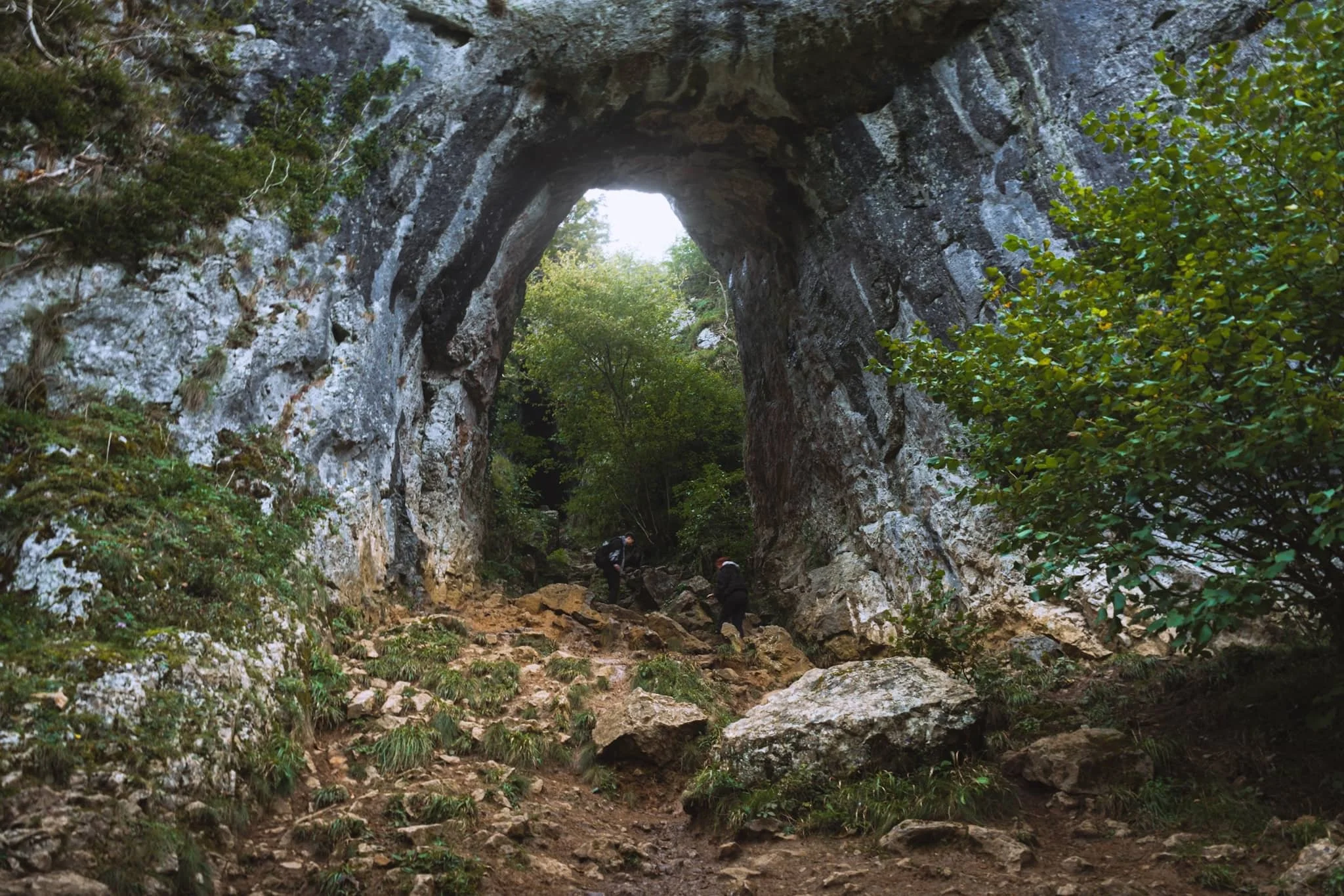
We paid particular attention to finding this spot, and were not disappointed. Beyond Tissington Spires an inconspicuous trail branches off the main valley footpath. It climbs up the steep valley side, revealing this monumental scene: a limestone archway, beyond which is Reynard’s Cave. A stupendous scene.
Beyond Raynard’s Cave, Dovedale narrows and deepens further into an area known as the Straits. Passage is possible only via a raised boarded trail. Once off the boards, we noticed a small cave with a clear and tempting stream trickling out of it.
The most accessible, and driest, caves in Dovedale are the Dove Holes, pictured here high above the trail.
Another solitary limestone spire pierces the sky above the woods.
The Dove Holes caves. They were formed during the last two ice ages by glacial water erosion. The caves became dry as the meltwater and river cut deeper into the gorge.
I got closer to the caves with my ultra-wide angle lens attached. It’s easy to imagine various ancient peoples and cultures have used these caves as shelter and storage.
The other, bigger, cave of Dove Holes, separated by a spire.
At Milldale, we paused for lunch and took the opportunity to wander around this bonny little village.
Milldale probably got its name from the corn mill that once stood on the River Dove here. Nowadays, it’s a sleepy little village with old stone cottages. Proper lovely.
After lunch it was time to take the return trip back down south the valley. This scene very much put me in mind of something like Yosemite.
One of the more famous spires in Dovedale can be seen on the right: Ilam Rock. Facing it is Pickering Tor. Ilam Rock rises 80 ft high from the valley floor, and is an impressive sight from any angle.
Near the Tissington Spires, Jacob’s Ladder rises above the woodland and catches the late afternoon light.
From below, the Tissington Spires are an imposing sight. Here they catch the golden afternoon light as the valley floor recedes into cold shadow.
Nearing the stepping stones once again, Dovedale’s most famous peak—Thorpe Cloud—comes into view. Here I took two exposures: one with my thumb covering the sun and one unobstructed. Blocking the sun with my thumb allowed me to blend the exposures with minimal lens flare.
Thorpe Cloud is an impressive pyramidal peak from across the River Dove.
One final look back into Dovedale before exiting for the day. An absolutely spectacular place.
Did you enjoy these photos?

Clapham & Trow Gill, Yorkshire Dales, Winter
The seasons progress and the weather is changing.
The seasons progress and the weather is changing.
After a month of near-constant rain interspersed with heavy fog, a high-pressure system is moving in and bringing with it clearer skies and lower temperatures.
Winter has arrived.
On Saturday we were greeted with clear skies and a biting wind. We ventured into the Yorkshire Dales—Clapham, to be precise—for a hike up towards and above Trow Gill. We would then scramble through the gill to get to the high moorland above for extensive panoramic views.
It were a crackin’ day for it.
All photos taken on my Fujifilm X-T2 using my Vivitar “Series 1” 28–105mm f2.8–3.8 zoom and Laowa 9mm f2.8 prime lenses. Developed in Capture One with the “Classic Chrome” Fujfilm simulation, finalised in Affinity Photo 2 for iPad,
Clapham & Trow Gill, Yorkshire Dales, Winter by Ian Cylkowski is licensed under CC BY-NC-SA 4.0![]()
![]()
![]()
![]()
It’d been a long time since I visited Clapham. In fact, I can recall the last time because I was still shooting with a Nikon D7000 that was nearly permanently attached to a tripod. This means the last time I was at Clapham was around 2016. Wow.
Here is something I do not remember from our last visit: a friggin’ waterfall! Turns out there’s been a lot of conservation work in recent years, some of which involved clearing the riverside bank here of snowberries, which was obscuring views of this waterfall.
The last of the year’s autumn colours in beautiful winter light.
Clapham Falls is a man-made waterfall, constructed as a three-tier drop underneath a bridge in the early 19th century by the Farrer family. They’ve long had established ties to the village and the 19th century saw a lot of landscaping and remodelling of the village.
This is something I wasn’t expecting to see in winter: flowering plants! I think this might be Mahonia japonica, which is apparently native to Taiwan. It flowers in winter through to spring.
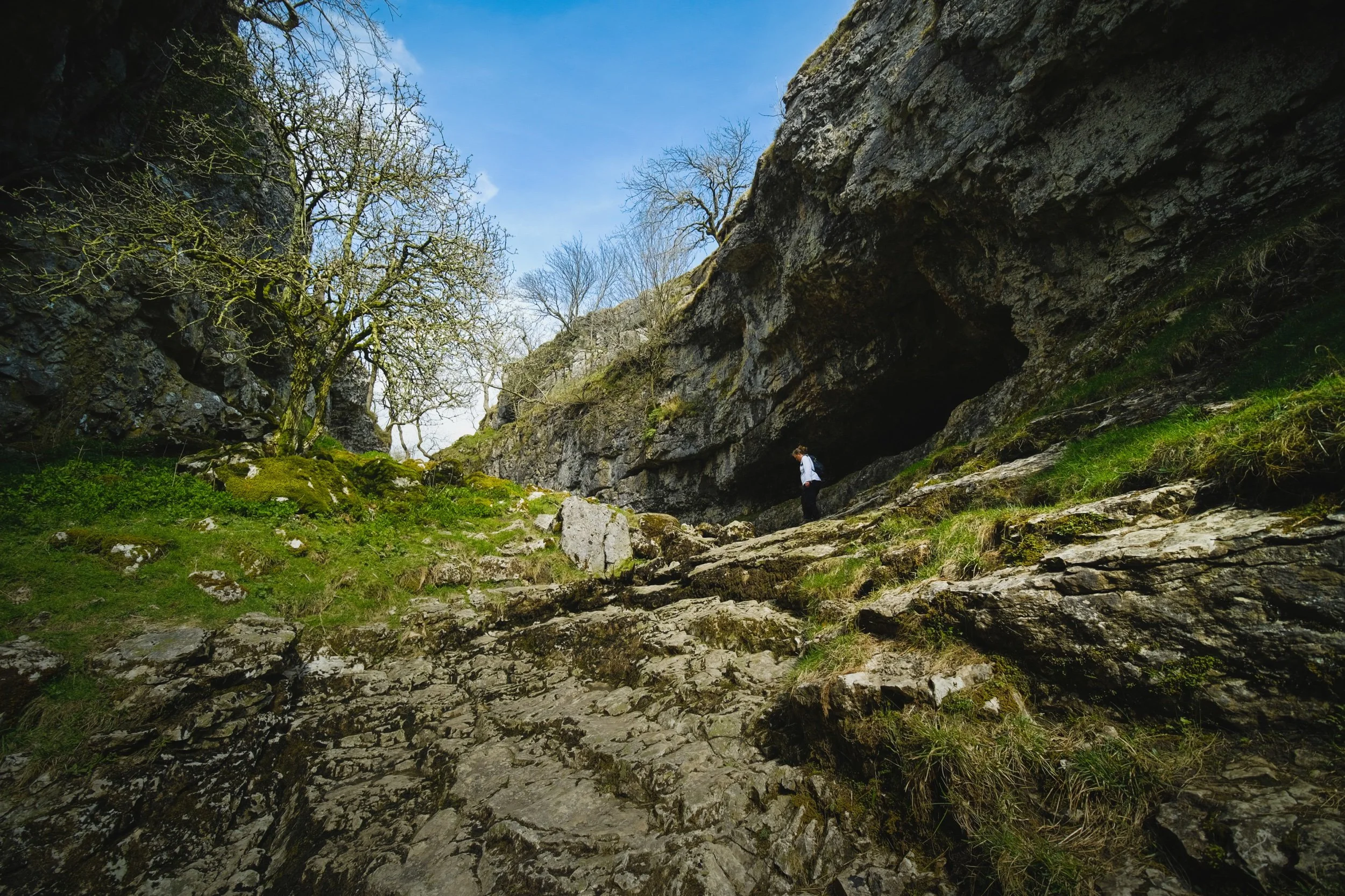
After working our way up and through Clapdale Wood and past the famous Ingleborough Show Cave we finally arrived at the entrance to Trow Gill.
Trow Gill is an immense ravine with 200ft high cliff walls. It was once the site of a massive waterfall, much like Troller’s Gill near Appletreewick.
We scrambled up the gill to access the high moorland above. From here, looking back down, I start to imagine what the waterfall would’ve looked like and the forces involved in sculpting this ravine. Immense.
The beck which once flowed through here as a raging waterfall begins life on the eastern slopes of Ingleborough. At some point in the distant past the beck no longer reached this ravine, instead falling underground near Ingleborough down a giant cavern now known as Gaping Gill. It is technically England’s single biggest drop waterfall, even though it falls underground.
Scrambling up and out of the gill, the land begins to open up and we can start to glimpse the eastern aspect of Ingleborough.
Above us, to the north, a limestone scar is drenched in winter light whilst the sky is ominously dark and cold.
The more unfamiliar view of Ingleborough. To the left is Little Ingleborough, with the main fell to the right. Though the trail continues on towards the fells, we decided to loop back and reconnect with the Pennine Bridleway.
Zooming right in on Little Ingleborough. You can just make out the tiny figures following the trail up the fell.
Up on the moorlands above Clapham, the views massively open up. Beyond Thwaite Scar we could make out the distant yet distinct shape of Pendle Hill, all the way in East Lancashire.
Even more impressively, Pen-y-Ghent was clear as a bell and looking spectacular.
The rolling landscape of the Yorkshire Dales, interspersed with karst limestone formations such as limestone pavements, scars, ridges, and of course the distinctive isolated fells.
Back on the Penine Bridleway south to Clapham, Thwaite Scar receives some late afternoon golden light.
Before dropping down to the village, I nab one final composition of Robin Proctor’s Scar—a sheer cliff face—being bathed in golden winter light.
Did you enjoy these photos?
Trollers Gill & Parcevall Hall, Yorkshire Dales, Spring
Happy belated Easter everyone. Did you have a good 'un?
Happy belated Easter everyone. Did you have a good 'un?
Usually for Cumbria, and the Lake District in particular, Easter signals the first tourism wave of the season. With that in mind, and no obligations to serve, Lisabet and I booked a couple of nights away in a beautiful B&B set in bonny Pateley Bridge, in the Nidderdale Area of Outstanding Natural Beauty.
We took the scenic route to Nidderdale from Cumbria, as we didn't need to check in until the evening. So, first we stopped off at the impossibly pretty Yorkshire Dales village of Burnsall for lunch and some light photography. Afterwards we continued east and stopped off near Grimwith Reservoir for the day's main activity: Trollers Gill.
This place has been on my radar, otherwise known as my Pinterest, for years.
It did not disappoint.
All photos shot on my Fujifilm X-T2 using my three prime lenses: a Fujinon 23mm f/2.0, a Laowa 9mm f/2.8, and an adapted Pentax SMC 55mm f/2.0. Images made 80% in-camera using the Astia film simulation, then finished off in Lightroom and Affinity Photo.
Burnsall
After coffee and a bacon butty near the river, we snapped some shots of Burnsall as we made our merry way back to the car. The 5-arched Burnsall Bridge here is a Grade II listed building, originally constructed in the 17th century with some 19th century improvements.
I'm not sure it's possible to get more Yorkshire than this scene. The Red Lion, built in the 16th century, and recently taken over by Thwaites Brewery.
Like many Yorkshire Dales villages, there's plenty of historical sandy limestone buildings decorated with beautiful greenery, flowers, and the distant hills.
Burnsall Primary School. Originally the old Grammar School founded in 1602 by William Craven of Appletreewick, who later became Lord Mayor of London.
Trollers Gill
After Burnsall, I identified a handy little parking area off the B6265 that would serve as the starting point of our hike to, and up, Trollers Gill. The day was bright and sunny whilst also hazy, lending a wonderful sense of intrigue and distance to photographs. Up on the moorland high above Appletreewick, views extended for miles and miles.
The path down the moorland was easy enough to follow, and soon the characteristic karst limestone landscape of the Yorkshire Dales became apparent.
The main signs pointing to Trollers Gill invite walkers to enter the ravine at the top and scramble their way down. Instead, we elected to take the trail around the western side of Middle Fell. This would eventually lead us to the bottom of Trollers Gill.
The anticipation and excitement builds as we near the bottom of the deep ravine.

At the bottom of Trollerdale, we followed the minor path north to start the climb up Trollers Gill. But first, I simply had to snap this glorious scene.
The entrance to Trollers Gill, largely dry for most of the year. Historically this would've been the site of a thunderous ravine with several waterfalls and cascades crashing down the gill. Thousands of years of erosion in a limestone landscape means the beck at the top of the gill now goes underground before entering the ravine, later reemerging at the bottom of Trollerdale.
Looking back at our way into Trollers Gill. Fellow hikers gingerly navigate the way down the ravine. Can you imagine this gorge full of water?
As with many other places in the Yorkshire Dales that features sheer limestone walls, Trollers Gill is a favourite for rock climbers.
Rock climbers assist each other as they ascertain routes up the sheer sides of Trollers Gill.
An ultra wide composition looking up from the bottom of what would've been a powerful waterfall. The meaning of the name "Trollers Gill" comes in two parts. "Gill" is already quite well known and used in Yorkshire and Cumbria, sometimes alternatively spelled as "Ghyll". It means a deep ravine or gully, and is cognate with the word gullet. "Trollers" is split into two: "troll" meaning, well, troll, the mythical beast (not the internet variety), and ears meaning "arse". This gives us "the Troll's arse". You're welcome.
Near the top of Trollers Gill, where the beck mysteriously disappears into the unfathomably twisted caves underneath.
Climbing out the gill and up onto the moorland, we realise that the haze has nearly cleared, giving us a fairly clear shot of Simon's Seat.
The deep drop into Trollers Gill that we had just climbed out of.
The single lane "New Road" that connects with the B6265.
A clear sign that a moorland is particularly and consistently wet: rushes everywhere.
One last look back at the farm track that guided us down into Trollers Gill.
A great discovery! Hanging on a branch near our parking spot was this beautifully preserved sheep's skull, probably a Swaledale. We took it home. Isn't it beautiful?
Parcevall Hall & Gardens
After returning to the car, we realised looking at the map that we were very near Parcevall Hall & Gardens. Fancy a quick visit and a wander? Why not?
Parcevall Hall is a Grade II listed Manor House that includes 24 acres of sculpted and maintained gardens. They were created in 1927 but fell into decline after 1960 following the death of Sir William Milner, 8th Baronet of Nun Appleton. Restoration work commenced in the 1980s.

People can visit and explore the gardens between April and October. It enjoys fabulous views and beautiful displays.
Lisabet and I particularly enjoyed this peaceful statue.
The Gardens, amongst other things, are known for their wonderful view of Trollers Gill, so we followed the route uphill.
Still plenty of daffodils around.
And there it is. Trollers Gill to the right and Middle Fell in the centre, daffodils blooming below. What a fantastic scene.
Cherry Blossom in full bloom at the entrance to the Gardens. What a full and gorgeous day.
Bullpot, Yorkshire Dales, Summer
The heatwave has finally ended.
The heatwave has finally ended.
After a week of temperatures pushing 30°C consistently with barely any air movement, today was looking a more comfortable 23°C with some wind.
About a month ago we embarked on one of our favourite local-ish walks, Barbondale in the Yorkshire Dales. On that occasion I was somewhat distracted by the sheer number of deer flies biting chunks out of me. Part of the Barbondale hike we did involved clambering over into Bullpot. We resolved to return to Bullpot for a deeper exploration of the area’s famous pot holes, gills, and caves, particularly Ease Gill Kirk.
After a lazy start, today was that day.
The dry ravines around the junction between Ease Gill and Leck Beck display some wonderful geology. Like a lot of the Yorkshire Dales, the gills here are largely made of limestone, which is porous and soluble in water. Limestone landscapes lend themselves to lots of waterfalls and cave systems, and the Ease Gill Cavern System is the longest and most complex cave system in Britain. As a result of the areas various potholes and caves, the area around Ease Gill Kirk is largely dry and full of “extinct” waterfalls, ready for exploration.
Which we duly did as best we could.
All photos taken on my Fujifilm X-T2 using my three prime lenses: a Samyang 35mm f/1.2, a Laowa 9mm f/2.8, and an adapted Pentax 55mm f/2.0 lens. Images made 80% in-camera using a customised Velvia film simulation, with minor edits afterwards in Lightroom and Affinity Photo.
The way to Ease Gill Kirk, after passing Bullpot Farm. The old farmhouse now serves as the base for the Red Rose Cave & Pothole Club.
The ruins of two lime kilns provide a hint as to the industrial heritage of this area.
The Bullpot valley features lots of dry stone walls that expertly trace the steep curves of the dale.
Layers and layers.
Our first sighting of the dry Ease Gill Kirk. Now to clamber down and explore…
We followed the dry river bed east up Ease Gill to find our first “waterfall”. The gill is largely dry now—save for periods of heavy rain—as the limestone geology of the area is water soluble. This means that the water that once carved out this river and waterfall now disappears further up the gill into a deep cave system, many miles below.
Nature is a fantastic sculptor. It was amazing to see the curves and forms created in the rock face by the waterfall that used to flow over here.
A stagnant pool is all that remains of this extinct waterfall.
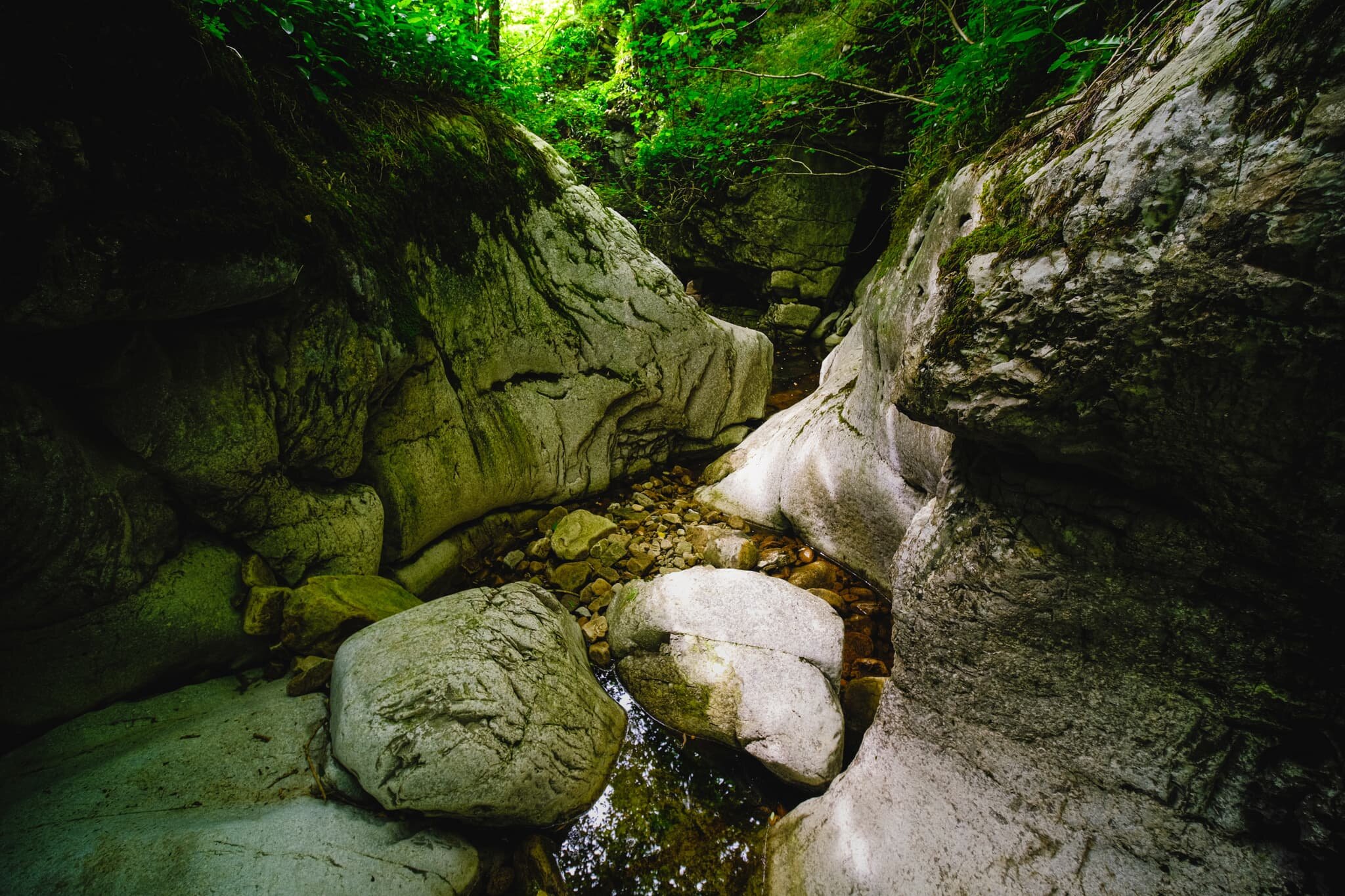
We exited back out of Ease Gill and made our way south to Ease Gill Kirk, following the dry river.
Lisabet and I scrambled down the gorge created by Ease Gill to capture this world of twists and turns. I’ve no doubt that with a good pair of wellies on, and a more adventurous spirit, you could follow this largely dry gorge a good distance. For now, this will do.
The ruins of Hellot Scales Barn, which serves now as a signpost of sorts for locating Ease Gill Kirk.
On the way back to Bullpot Farm I, of course, had to snap some compositions of the brilliant dry stone walls here.
Just follow the wall all the way back to Bullpot Farm. I suspect in wetter months the path between Bullpot Farm and Ease Gill Kirk would be consistently boggy.
The area near Bullpot Farm is home to lots of shake holes, not to mention one of the main entrances into the Ease Gill Cave System, ominously called “Bull Pot of the Witches”.
I saw it, lined it up, and took a photo of it.
One final shot of the wall of fells above Barbondale known as Calf Top.

Watlowes Dry Valley, Yorkshire Dales, Summer/Autumn
We finally got a week off.
We finally got a week off.
The pandemic, and its subsequent lockdown, has been pretty intense for me and Lisabet. I took on extra roles and responsibilities, with less available work time, and Lisabet’s job changed fundamentally. And we continued working throughout the lockdown.
So we were so ready for a break, which finally arrived at the end of August.
We stayed a few nights in a cosy B&B just south of Skipton, a beautiful market town on the edge of the Yorkshire Dales. On our way we took a scenic detour and stopped at Malham Tarn for a little stroll down to the Watlowes Dry Valley and back.
As its name suggests, the Watlowes Dry Valley is in fact the site of an extinct waterfall. The outflow from Malham Tarn once channeled out a deep gorge and powerful waterfall from all the surrounding limestone, before turning southeast and dropping over Malham Cove, in what surely would’ve been the UK’s biggest waterfall (estimates suggest the waterfall over Malham Cove would’ve been 980ft wide and dropped 260 ft).
However, at some point in history, the outflow from Malham Tarn stopped running through Watlowes and Malham Cove dried up. Nowadays, the stream suddenly disappears into the ground 500 m from the tarn, in an area now known as Watersinks. Below here, the stream travels through a myriad of underground caves before emerging above land once again at Aire Head, just south of Malham village.
All photos taken on a Fujifilm X-T2 with a Fujinon XF 18–55mm f/2.8–4.0 lens using a customised Velvia film profile.
It’s clear to see how the river used to flow through this gorge, cutting out chunks of limestone and deepening the ravine as it did.
The gorge deepens and narrows.
Looking back at some fellow hikers, taking photos at the site of the extinct waterfall.
The river would’ve crashed down here as a waterfall before turning southeast and cutting out a valley on its way towards Malham Cove.
One of the limestone crags above the gorge.
The extent of the Watlowes Dry Valley, with the sheer face of Comb Hill to the left and Ing Scar to the right.
After returning back to the car, and then navigating through a frankly overcrowded Malham village, we stopped off at Town End Farm Shop for refreshment. The views from the farm back to Malham are sublime. Highlighted in the distance, you can just make out the curved wall that is Malham Cove.
A seriously beautiful farm cottage at Town End.
Across the road, another lovely farm cottage.
Whilst waiting for Lisabet, I noticed a small butterfly land on plant pot near and seemed preoccupied enough for me to snag a photo or two of it. Turns out this is a Small White butterfly, or Pieris rapae.

Catrigg Force, Yorkshire Dales, Summer
With all the rain falling in the North of England at the moment, it seems a good opportunity to revisit some of our favourite waterfalls.
With all the rain falling in the North of England at the moment, it seems a good opportunity to revisit some of our favourite waterfalls.
As I’ve mentioned elsewhere, you’re spoilt for choice when it comes to waterfalls in the Yorkshire Dales. In fact, the Yorkshire Dales is home to the highest unbroken-drop waterfall in England, Gaping Gill (if you count the fact that it drops 322 ft into an underground cavern). If you want above-ground only, then the claim is held by Hardraw Force also in the Yorkshire Dales, a single drop of 100 ft.
But there’s plenty of other waterfalls to check out in the Yorkshire Dales. One of our favourites is Catrigg Force, found via a short but steep hike up the Pennine Bridleway east from Stainforth, just north of Settle. Here, Catrigg Beck meanders gently southwest from the slopes of Knowe Fell (593 m/1,945 ft) before plunging 20 ft into a wooded ravine. It’s a magical place.
All photos shot with my Fujifilm X-T2 with a Fujinon XF 18–55mm f/2.8–4 lens using a customised Provia film emulation.
Stainforth is a ridiculously pretty village, in true Yorkshire Dales fashion.
The pull up the Pennine Bridleway from Stainforth begins, where the views quickly open up.
We weren’t the only ones on this hike, and there were plenty of groups—families and friends—hiking up the Pennine Bridleway to see the falls.
Can never resist a shot of the drystone walls of the Yorkshire Dales.
The “nose” in the distance is Smearsett Scar (363 m/1,191 ft).
The copse that hides the ravine where Catrigg Force resides. In the distance the clouds start to lift off one of the Yorkshire Dales Three Peaks: Pen-y-ghent (694 m/2,277 ft).
You can actually get right near the top of Catrigg Force, just before it plunges 20 ft into the ravine below.

Catrigg Force, set in its own beautiful little ravine.
Plenty of people were trying to get closer to the falls, which is tricky because the limestone rocks around here were wet and covered in mud, making them super slippy.
Doesn’t stop people trying.
Back out of the ravine, we rejoined the Pennine Bridleway through Upper and Lower Winskill.
And then started to drop down towards Stainforth, pausing to drink in the views.
After navigating the rather steep and slippery descent down Stainforth Scar, we navigated through the fields back to the village.
A lovely Yorkshire Dales scene.
That’s one happy kitty.