
Stenkrith Park, Cumbria, Winter
By the gods, there has been a lot of rain.
By the gods, there has been a lot of rain.
It’s made getting out for some winter hiking difficult, if not impossible. In decades past, the Lake District was more known for a lurking misty drizzle that saturated everything. With climate change ever more present, these days rain in Cumbria crashes down in sheets of massive downpours, overwhelming infrastructure and rivers alike.
Finally, after careful cross-examination of various weather services, there appeared to be a gap in all the rain. We quickly made our way to an area not only familiar to us but that also had the best chance of some clear skies: Stenkrith Park in Kirkby Stephen.
It felt good to be out.
All photos taken on my Fujifilm X-T2 using my Vivitar “Series 1” 28–105mm f2.8–3.8 zoom and Laowa 9mm ultra-wide prime lenses. Shot using the camera’s Pro Negative Standard film emulation. RAWs developed in Capture One for iPad, and finalised in Affinity Photo 2 for iPad.
Stenkirth Park, Cumbria, Winter by Ian Cylkowski is licensed under CC BY-NC-SA 4.0![]()
![]()
![]()
![]()
The crown of Stenkrith Park, known as the Devil’s Grinding Mill. Here the River Eden takes a sharp bend and has carved a deep and narrow gorge, dropping in several stages below the Millennium Bridge. It’s a spectacular sight, but I’ve never seen this much water flowing through. It was roaring.
We followed the Northern Viaduct trail towards the village of Hartley, the trees now bare. Winter afternoon light showed the way forward.
From atop Podgill Viaduct there are excellent views all the way to the Northern Pennines. Their summits never escaped the clouds.
Looking the other way from Podgill Viaduct. The bare trees allow the shape of the meandering beck to be more visible, making a stronger leading line towards the hills.
Kirkby Stephen’s always a pleasure to visit. We stopped for lunch and a potter around some of the charity shops, before relocating the River Eden for the return stretch of the walk.
Quintessential British quirkiness or a scene of horror? You decide!
Did you enjoy these photos?

Brough Castle, Cumbria, Spring
My shoulder’s starting to feel well enough for some more energetic and long-distance hikes.
My shoulder’s starting to feel well enough for some more energetic and long distance hikes.
With the weather forecast finally looking nice for the weekend, we spent Saturday with my Dad and took him to the historic village of Brough in Cumbria. Here one can find the impressive ruins of the 11th century Brough Castle.
The castle was built on the site of an older Roman fortification, called Verterae. The fort was in use until the 5th century. After William the Conqueror’s subjugation of England in 1066, his son—William Rufus—built Brough Castle in 1092 on top of the old Roman fort after successfully invading Northern England. The site of the old fort and castle overlooks Stainmore Pass and the River Eden, an important strategic stronghold.
Over the ensuing centuries, Northern England became a battle ground between the Kings of Scotland and England. In time, Brough Castle came into the hands of Clifford family. In particular, Lady Anne Clifford completely restored the castle in the 17th century, alongside a number of other properties within her vast estate. A fire broke out in 1666, gutting the castle. It fell into decline shortly afterwards, intermittently being stripped of stone for other constructions.
Brough Castle is now managed by English Heritage, who look after the ruins. We enjoyed a wander around these historical ruins, followed by a brief jaunt further along the Pennine Bridleway. Unfortunately, after February’s storms, most of this part of the bridleway was boggy and thick with greasy mud. We bailed on this occasion and resolved to do the hike again during drier conditions.
All photos taken on my Fujifilm X-T2 using my three prime lenses: a Fujinon 23mm f/2.0, a Laowa 9mm f/2.8, and an adapted Pentax SMC 55mm f/2.0. Images developed using RNI Films’ Fortia SP film profile.
The route to Brough Castle enjoys spectacular clear views towards the Northern Pennines. No wonder this area has been used to build fortifications for so long.
And there she is. This is the southeastern profile of the castle, showing Clifford’s Tower and its 17th-century windows.
A young family ahead of us excitedly entered the grounds.
Once in the grounds of the ruins, it was time to don my ultra-wide lens for some vast compositions of the castle.
This composition was shot underneath the 12th-century arch, with a view towards the 17th-century Keep in the distance. A mind-boggling sense of time and history.

These hall ranges were last modified in the 14th-century. To the right, high up, is the high wall of the gatehouse.
At the other end of the site, we approached the imposing Keep. It was last modified by Lady Anne Clifford in the 17th-century, and she lived in it for a period during 1665.
The Keep, originally built in the 12th-century, enjoys excellent panoramic views to the River Eden.
The Gatehouse and ranges from the Keep. I don’t know why, but this photo puts me in mind of Machu Picchu.
In the neighbouring fields, horses graze peacefully. In the distance, the flat-topped Wild Boar Fell in Mallerstang can be made out.
What magnificent structures. Their remains tell a story 1,000-years old.
I made one more ultra-wide composition of the inner and outer ranges as the light was so good.
After exiting the ruins, we located the Pennine Bridleway and followed the trail west towards the River Eden.
The views quickly open up and we are afforded lovely scenes looking back at the ruins of Brough Castle.
Looking south across the fields to the Mallerstang valley, flanked by Wild Boar Fell and Mallerstang Edge.
Though the day was sunny and clear, there was a strong and bitingly cold wind. This meant the sun made intermittent appearances, variously scanning across the land in many patterns. Upon spotting this composition, I lined everything up and simply waited for the sun to break free of the clouds again to highlight the castle ruins.
It’s easy to see why there’s been a fort of some kind here since the Ancient Roman times.
The fields will soon fill up lambs once again.
Spring is on her way.

Kirkoswald, Cumbria, Winter
Welcome to the ancient village of Kirkoswald.
Welcome to the ancient village of Kirkoswald.
The day ahead looked to be rather changeable, with unpredictable downpours combined with gusty winds. Our best bet was to head to Northern Cumbria. So why not spend a day with Dad?
We all ventured to Kirkoswald for a gentle stroll around the area. The village is timeworn, with many buildings still standing since the 1600s and 1700s. Even older—to the south of the village—is St. Oswald’s Church, with parts of it dating back to the 12th century. The church is, in fact, where the village gets its name: “Kirk” is the Old Norse word for “church”. It is thought that the body of Saint Oswald, King of Northumbria, was taken through the village.
Southwest of the village is Eden Bridge, a beautiful red sandstone construction. It dates from 1762, with repairs made in the 19th and 20th centuries.
Thankfully the day was largely cooperative, weather-wise, and we all enjoyed some lovely photography walking around this ancient parish.
All photos shot on my Fujifilm X-T2 using my three prime lenses: a Fujinon 23mm f/2.0, a Laowa 9mm f/2.8, and an adapted Pentax SMC 55mm f/2.0. All images 95% made in-camera using Øyvind Nordhagen’s Modern Documentary Fujifilm recipe, with cropping and framing in Pixelmator and Darkroom.
My Dad’s lovely little farm cottage, in the middle of nowhere of Northern Cumbria.
The road that passes by Dad’s cottage.
Dad set up a load of bird feeders outside the cottage, home to many species that he’s always happy to take photos of.
We parked at a small car park just before the Lazonby Eden Bridge. This signalled the start of our walk into Kirkoswald. The River Eden was rather high and fast.
On the Kirkoswald side of the main bridge that spans the River Eden are these “dry arches” that were, nevertheless, flooded.
She’s a beaut of an 18th century bridge.
I whipped on my 9mm ultra wide lens to capture the whole span of the bridge as well as the lovely cloud textures that were forming.
One last look back along the entire span of the bridge before carrying on towards Kirkoswald.
Evidence of Storm Arwen’s vengeance on trees across the UK.
We took the permissive footpath from Eden Bridge into Kirkoswald, then through the church gate to follow the old cobbled path towards St. Oswald’s Church.
The church is in a beautiful setting.
There she is, St. Oswald’s Church. The building’s unique in having a 19th-century bell tower on top of a hill 200 yards from the church itself.
The main entrance to the church. Historic England specifies this timber frame thus: “North timber-framed gabled porch of c1523”. So 500-years old.
Small, and old, but humble.
People are still buried in this church’s graveyard. I spotted a gravestone for January 2021. I’m sure there are conditions/restrictions that need to be satisfied for burial here.
Love the wrought iron works around the churchyard.
A rather grand entrance to an estate of some sort.
Crossing over the small bridge that spans Raven Beck. Ancient red sandstone buildings everywhere.
Not sure what these folk were doing along the shores of the beck… but I had to snap them.
One of many buildings in Kirkoswald dating from the 18th century. This one’s datestone reads 1713.
The Crown Inn, still very much in operation. It’s an old coaching inn, again from the 18th century.
On t’other side of t’road, Lisabet inspects the menu for the Featherston Arms.
Love old buildings that are wrapped in branches and vines.
Victorian-era road signage, which still references Cumberland County Council.
Out of the top of Kirkoswald, the views across the Eden Valley are extensive.
The village square. Kirkoswald gained a Market Charter in the 13th century, and hosted markets at the village square for centuries. This then moved to the Lazonby and Kirkoswald Railway Station after the opening of the Settle–Carlisle line in 1876.
Heading back to Eden Bridge via the permissive footpath, I spy a simple composition as the storm clouds build up above.
A high and fast-flowing River Eden from the top of Eden Bridge.

Stenkrith Park, Kirkby Stephen, Cumbria, Spring
Woohoo, Spring Bank Holiday weekend!
Woohoo, Spring Bank Holiday weekend!
On the first day of our 3-day weekend, we ventured northeast towards the bonny Cumbrian town of Kirkby Stephen. Aware of the rush of people heading into the Lake District, we’ve decided to largely stay out of Cumbria for this Bank Holiday. Near Kirkby Stephen is Stenkrith Park, which I’ve written about before. Here one can enjoy the incredible sights of the River Eden and the limestone gorge it’s created, then follow the Viaduct Trail for more glorious views and scenes.
Fortuitously, the weather’s decided to perk up just as the Bank Holiday arrived. Although hazy, the sun was warm and conditions were uplifting. Summer is finally coming.
All photos shot on my Fujifilm X-T2 using my three prime lenses: a Samyang 35mm f/1.2, a Laowa 9mm f/2.8, and an adapted Pentax SMC 55mm f/2.0 lens. Image made 80% in-camera using a customised Classic Chrome film simulation, the minor edits afterward in Lightroom and Affinity Photo.
The “Devil’s Grinding Mill” viewed from the Millenium Bridge. This is where the River Eden has carved out a gorge deep into a collapsed cave system. With the viaduct serving as a frame, it makes a wonderful scene.
Lovely to see families out enjoying the trail, too.
Around here, it’s easy to tell that this trail was once a railway line.
A lovely cluster of dock leaves, or Rumex obtusifolius. You can often find these growing near stinging nettles. Folklore states that if you’re stung by stinging nettles, rubbing the affected area with some dock leaves soothes the pain. Unfortunately, there’s no evidence this actually works.
Looking straight down at Pod Gill from high up Podgill Viaduct. A seriously gorgeous day.
Nowt like wandering amongst the fruiting vegetation and breathing in the summery fragrances.
A couple of Swaledale ewes and their lambs nibbling away at the hedges. In the far distance to the right is the unmistakeable peak of Wild Boar Fell.
The way back into Kirkby Stephen, over Frank’s Bridge, a 17th-century Grade II listed stone foot bridge.
Kirkby Stephen is an old town, with records dating back at least to the Domesday Book of 1086, where the town was recorded as “Cherkaby Stephen”. This door belongs to Mitre House, dating back to 1663.
I took a shot of this statue mostly for my own reference. She’s located in the town centre and there’s no plaque or stone indicating who she is. Turns out it’s Lady Anne Clifford, unveiled in September 2020. Lady Anne improved and expanded lots of her family’s properties around Westmorland, as well as restoring churches in the area.
Pubs, cafes, and restaurants are all quickly filling up once again. It very much seems that life is starting to return to “normal”, whatever that is.
Did you know there’s a Clock Museum in Kirkby Stephen? I didn’t.
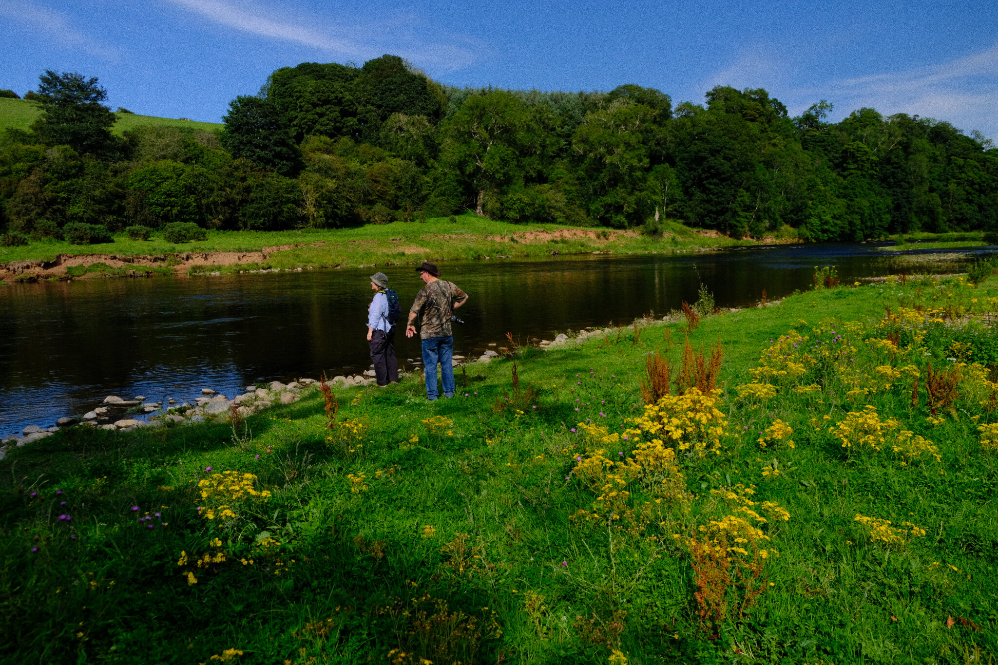
Making our way back to Stenkrith Park, the trail runs alongside the River Eden, which we had fun exploring. There’s loads of beautifully carved limestone and rushing cascades to photograph. This child was not happy that we were standing on “his” rock.
A lovely series of cascades.
One of the ledges in the river features this hollowed out hole with the river running underneath it.
Trying to get as close to some of the bigger cascades as I could.
Plenty of flowering wild garlic in the woods of Stenkrith Park, too.
On this day, this was close as we could get to the Devil’s Grinding Mill, the main drop of the River Eden. Nevertheless, it was lovely to shoot the soft light and textures in the gorge.
All the wild garlic, plus an inscribed poem for your viewing pleasure.
Bonus: the Lune Gorge near Tebay
For an added extra, we stopped off near Tebay on our way home to clamber down into the Lune Gorge for some more photos. Plenty of water in the Lune meant incredible sights and sounds.
My lovely Lisabet doing what she does best: getting close to the action.
My turn for a view underneath the bridge.
The powerful cascades of the Lune Gorge.
The view of the Lune Gorge downstream.
The Lune Gorge from high up the river’s banks.

Stenkrith Park, Cumbria, Autumn
The River Eden has carved out some wonderful geology.
The River Eden has carved out some wonderful geology.
If you’re a frequent visitor of my website (hello!) you’ll have read me writing about the River Eden’s geology specifically around Mallerstang and Wetheral.
The River Eden begins life high up in the Mallerstang valley—now part of the Yorkshire Dales National Park—where it has carved an impressive gorge known as Hell Gill, before dropping 25 ft as a waterfall called Hellgill Force. The river turns north, carving its way out of Mallerstang into the wider Vale of Eden.
Just before the river reaches the small Cumbrian town of Kirkby Stephen, it drops through a partially collapsed cave system in Stenkrith Park called “The Devil’s Grinding Mill” (also known as “The Devil’s Mustard Mill” and “Coop Kernan Hole”). The scenery here is absolutely fascinating.
We took the opportunity for a more gentle walk, starting at Stenkrith Park and following the Northern Viaduct trail to take in the sights of both Pod Gill Viaduct and Merrygill Viaduct. We then circled back into Kirkby Stephen before rejoining the River Eden for some more river photography of the incredible limestone formations.
All photos shot on a Fujifilm X-T2 with a Fujinon 18-55mm f/2.8-4.0 lens using a customised Classic Chrome film profile.
This is “The Devil’s Grinding Mill”, where the River Eden drops into a collapsed cave system. The Millennium Bridge crosses above the gorge for fantastic views.
From the bridge we followed the North Viaduct trail east. The trail follows the old South Durham & Lancashire Union Railway, which was setup in the 1850s to transport coke (the fuel kind) to Barrow-in-Furness’ iron furnaces. The railway was dismantled in the 1970s.
We saw plenty of people walking the Northern Viaduct trail, especially with their dogs.
If you’re in Cumbria, there will be sheep. I managed to surprise this Swaledale.
Just south of Coop Kernan Hole the River Eden begins widening out again through a series of beautifully sculpted limestone formations.
There was some lovely light filtering through.
Autumn’s quickly on its way.
The red colouration in the water is due to the river carrying peat from the fells above Mallerstang.
My lovely Lisabet found a sizeable hole in the one of the rocks, and I couldn’t resist a photo!
Lisabet hopping rocks to get a closer shot of some of the falls.
This is the bottom of Coop Kernan’s Hole, only really accessible when there’s no much water in the river.
A little bit of sun managed to break through the canopy, picking out some of the features of this fascinating gorge and its structures.
Wetheral, Cumbria, Summer
The heatwaves have returned.
The heatwaves have returned.
After a pretty damp July, at least in Cumbria, we’ve recently experienced temperatures approaching 30°C. Lisabet and I decided to take advantage of this Glorious Return Of Summer by paying my Dad another visit.
The last time we visited my Dad was towards end of June, where we enjoyed a delicious BBQ followed by a wander around some of the less-visited parts of the Lake District. At least, that was the plan. Unfortunately I suffered one of the worst hayfever attacks I’ve ever experienced, which somewhat marred the day and we cut it short.
Yesterday we decided to attempt Round 2, now that I had been inoculated after a month-long course of Corticosteroids. Thankfully, things went a lot better.
Here are the photos from that day, where we explored the impossibly pretty Wetheral village, near Carlisle.
All photos shot on a Fujifilm X-T2 with a Fujinon XF 18–55mm f/2.8–4.0 lens and a Marumi DHG Super Circular Polariser attached. Photos are 95% SOOC, with minor edits made using Fujifilm X RAW Studio.
My Dad’s ridiculously lovely farm cottage (Velvia, ISO800, f/3.4, 1/2500sec. @ 18mm)
Wetheral Parish Church. The Church contains a life-size sculpture by Joseph Nollekens of 'Faith'. In the late 18th century the sculpture cost £1,500, which makes it near to £2 million today (Velvia, ISO800, f/3.7, 1/2500sec. @ 31.5mm)
Corby Bridge, also known as Wetheral Viaduct, which carries the Newcastle–Carlisle railway (Velvia, IS800, f/3.7, 1/2000sec. @ 32.9mm)
At Wetheral the River Eden has created quite an impressive gorge, surrounded by ancient woodlands. We saw loads of people playing about in the river on this beautiful day, and why not? (Provia, ISO800, f/3.0, 1/2500sec. @ 18mm)
A short walk from the village alongside the River Eden, one can find some man-made caves carved out of the gorge walls. They were said to used by the monks as early as the 14th century as places of refuge during border warfare (Astia, ISO800, f/3.0, 1/50sec @ 18mm).
Local legend goes that these cells were carved out of the gorge rock by Constantine, a younger son of a Scottish monarch (Astia, ISO1600, f/2.8, 1/25sec. @ 18mm)
No idea what this is or why it’s in an ancient woodland… (Provia, ISO800, f/3.0, 1/20sec. @ 18mm)
Dad, navigating the steps back out of the caves (Astia, ISO1600, f/3.0, 1/30sec. @ 18mm)
This is Impatiens glandulifera, also known as “policeman's helmet”, “bobby tops”, “copper tops”, and “gnome's hatstand”. Originally native to the Himalayas, now classed as an invasive species (Velvia, ISO800, f/4.0, 1/100sec. @ 55mm)
There were a lot of bobby tops by the River Eden (Provia, ISO800, f/3.4, 1/200sec. @ 18mm)
This is dotted loosestrife (Lysimachia punctata), native around Southeast Europe and the Caucasus, it grows well on rough and damp ground (Velvia, ISO800, f/3.6, 1/400sec. @ 35.8mm)
And then we exited the woodland and… wow. Flowers everywhere (Velvia, ISO800, f/3.2, 1/2500sec. @ 25.4mm)
Just me, Lisabet, and me Dad. A tranquil scene (Velvia, ISO800, f/3.2, 1/2500sec. @ 18mm)
Climbing away from the river back up to the country lanes, we came across two very curious horses (Shire? Clydesdale? Couldn’t say). They were cute, we made friends (Astia, ISO800, f/3.2, 1/800sec. @ 18mm)
The way back to Wetheral, all the way through the fields (Velvia, ISO800, f/4.0, 1/800sec. @ 55mm)
There’s been a Benedictine Priory in Wetheral since the 1100s, but nowadays only the Gatehouse remains, which was probably built in the 1400s. These days it’s looked after by English Heritage (Velvia, ISO800, f/3.6, 1/1000secs. @ 39mm)
Post-walk, it was back to Dad’s for some BBQ goodness (Provia, ISO800, f/4.0, 1/100sec. @ 55mm)
Getting everything set up… (Provia, ISO800, f/3.6, 1/200sec. @ 32.9mm)
My Dad’s cooler than your Dad (Provia, ISO800, f/4.0, 1/200sec. @ 55mm)
Let’s eat! (Provia, ISO800, f/3.2, 1/250 sec. @ 27.7mm)