
Hodbarrow Nature Reserve, Cumbria, Autumn
Time for somewhere a little different.
Time for somewhere a little different.
For a little while now we’ve had our peripheral vision on a little-known nature reserve in southwest Cumbria: Hodbarrow Nature Reserve.
Today was the day to visit and explore it.
The nature reserve occupies the site of a former iron ore mine, which was in operation until the 1960s. The RSPB purchased the nature reserve in 1986, and are managing the area to sustain numbers of terns, wintering red-breasted mergansers, as well as wintering teals, coots, little grebes, redshanks and dunlins, and breeding great crested grebes. They are also looking to re-establish the nationally rare natterjack toad.
While parts of eastern Cumbria and North Yorkshire were looking cloudy and rainy, the southwest Cumbrian coast at Millom was thankfully sunny and clear, with gorgeous painterly high-altitude clouds aiding our photos.
Photos taken on my Fujifilm X-T2 using my Vivitar “Series 1” 28–105mm f2.8–3.8 zoom and Laowa 9mm f2.8 prime lenses. Images are 90% made in-camera using Shark & Palm’s “Kodak Ektar 100” film recipe. Finalised using Affinity Photo 2 for iPad.
Hodbarrow Nature Reserve, Cumbria, Autumn by Ian Cylkowski is licensed under CC BY-NC-SA 4.0![]()
![]()
![]()
![]()
What became immediately obvious to me and Lisabet upon our arrival was how quiet the nature reserve was. Absolutely delightful.
Beautiful “brush stroke” clouds decorated the skies above the flooded “lagoon” of the nature reserve.
The fell that commands your attention all around the nature reserve is Black Combe, an isolated Lake District fell of 600m high.
However, further into the distance are the Coniston fells, looking sublime as the clouds cast painterly shadows across the slopes of the fells.
An old abandoned lighthouse, possibly abandoned in favour of the newer one further southeast of the nature reserve. The little stub of a building in the distance to the right is the ruins of a windmill. The old windmill was used by Hodbarrow Iron Ore Mine to store gunpowder, used for blasting, between 1855 and 1880, when a purpose-built facility was built.
A clearer panorama of the Coniston fells.
A crackin’ composition I couldn’t resist. The old lighthouse reflected in the lagoon with the hump of Black Combe in the distance.
The crags of Hodbarrow Point, subject to constant erosion by the tides of the Duddon Estuary, itself connected to Morecambe Bay.
Beautiful strokes of painterly clouds adorn the skies above Black Combe. Attached to the nature reserve’s lagoon is the Hodbarrow Marina.
An old couple enjoy the views across the Duddon Estuary as feathery clouds streak across the sky.
As we approached the newer lighthouse, I noticed lots of large puddles nearby the enticed me to try my hand at a reflection composition. Not bad.
The “lagoon” of the nature reserve is protected from the sea by this beautiful sea wall, built in 1905.
Faded grandeur. Plus the streaky clouds enabled an ultra-wide composition as they “pointed” towards the lighthouse.
From the top of the sea wall, the ever-stretching expanse of Haverigg beach comes into view.
Looking along the sea wall all the way back to the Furness peninsula.
A simple scene, but beautiful nonetheless.
I enjoy the way the curve of the lagoon is mirrored in the curves of the clouds above.
After lunch, we re-emerged into the nature reserve with considerably more cloud cover. The Lakeland fells, however, were still looking magnificent.
The clouds grew larger and tighter around the sun. That would be it for the day.
Did you enjoy these photos?
Various Places, Loch Lomond & the Trossachs, Autumn, Scotland
Our Loch Lomond holiday is over.
Our Loch Lomond holiday is over.
But before I say goodbye, here’s some bonus photos that didn’t really fit in with any of my other Loch Lomond Holiday posts.
I hope you enjoy them. Until next time, Scotland…
All photos taken on my Fujifilm X-T2 using my two prime lenses: a Laowa 9mm f/2.8 and an adapted Pentax SMC 55mm f/2.0 lens. Developed using RNI Films.
Kilchurn Castle & Loch Awe
Beyond the northwestern corner of the Loch Lomond & the Trossachs National Park, one can find the shores of Loch Awe and the mighty peak of Ben Cruachan (1,126 m/3,694 ft). Below the mountain lies the ruins of Kilchurn Castle, originally constructed in the 15th century as the base of the Campbells of Glenorchy. I shot this 9-image panorama using my 55mm lens to really capture the mood and setting of this scene.
Across the valley from Ben Cruachan is Beinn Eunaich (989 m/3,245 ft) with the waterfall Steallair Eùnaich rushing down its flanks. On this day, the clouds did not leave the mountain tops.
We walked to Kilchurn Castle for a closer look. As we neared the ruins, the view east briefly opened up and revealed the mountains around Ben Lui (1,130 m/3,710 ft), complete with swirling clouds.
The Falls of Falloch
North of Loch Lomond one can easily find, signposted off the main road, the Falls of Falloch and its own little car park. A brief 5-minute walk from the car park presents you with this magnificent powerful waterfall.
A 5-image vertorama on my 55mm lens reveals the full extent of the Falls of Falloch. After a week or so of low pressure systems bringing near-constant rainfall, the waterfall was positively roaring.
A fallen twig with a solitary leaf provided the perfect foreground subject for this 9mm ultra-wide composition as the falls became illuminated by the sun.
A small gap in a fence allowed access to a ledge that give me a nice open view of the falls for this composition. The pool below the waterfall is apparently known as “Rob Roy’s Bathtub”.
In 2013 a steel cage viewpoint known as the Woven Sound was constructed to enable tourists to view the falls without disturbing a lot of the surrounding area. This is the view from it.
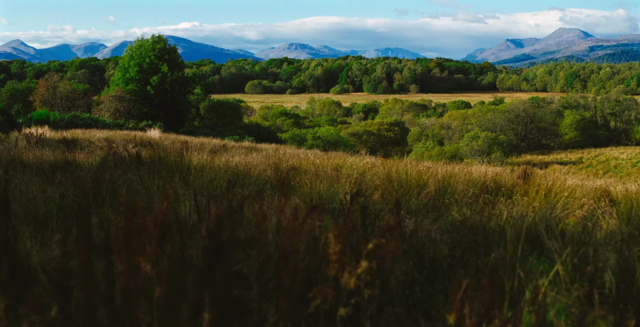
RSPB Scotland Loch Lomond Nature Reserve
From our little cottage accommodation, a brief 5–10 minute walk took us to RSPB Scotland’s Loch Lomond Nature Reserve. As well as exploring the marshy woodland, it offers a frankly stunning viewpoint, taking in the entirety of the Loch Lomond mountains. A stitched together this panorama with my 55mm lens in an attempt to accurately capture the entire view.
A tiny little beck with criss-crossing tree trunks provides a strong foreground interest for this beautiful woodland scene in the Loch Lomond Nature Reserve.
The Falls of Leny
On our way to Balquhidder, we stopped off for a small diversion just south of Loch Lubnaig. There, one can take the barely noticeable trail that follows the main road until the roaring sound of water guides you to this incredible scene. These are the Falls of Leny. This is large panorama shot with my 55mm lens and stitched together to get this incredibly detailed and wide view of the falls.
My ultra-wide 9mm lens reveals the context of this waterfall and the gorge it’s created in the river Garbh Uisge, which is Gaelic for “rough water”. Appropriate.

Swindale, Lake District, Spring
We finally got the opportunity to explore one of the Lake District’s “hidden” valleys.
We finally got the opportunity to explore one of the Lake District’s “hidden” valleys.
I’ve had Swindale bookmarked in my Pinterest for years now. What drew me to the area was looking at maps of the valley’s head, appropriately called Swindale Head. Here you can find a series of cascades and waterfalls dropping down 300 ft of crag, known as Forces Falls.
Reality, thankfully, was much better than any map or Google Image Search.
Swindale is not the easiest valley to find, and I suspect most people near the area venture either to Ullswater or Haweswater. Certainly, driving up the A6 through Shap, you’d have no idea of Swindale’s existence, especially as the valley is well obscured by Rosgill Moor and Ralfland Forest.
The valley is part of RSPB Haweswater and aspects of it are being “restored” to more natural features ever since 2012. In 2016, the beck running through the valley was “rewiggled”; previously, the beck had been straightened a couple of hundred years ago to prevent the flooding of hay meadows. This had knock-on effects—as man’s meddling in nature does—primarily with salmon and trout that were no longer able to spawn in the straightened and now-fast flowing river. Once the beck had been rewiggled, salmon returned to spawn, and the diversity of the beck’s flora and fauna continues to improve.
After negotiating the myriad of minor country roads, we arrived near Swindale Foot Farm to park at the small lay-by. Then it was a simple task to follow the road, which increasingly became a gravely lane, all the way into the valley towards Forces Falls at the head of the valley.
Photographically, conditions were challenging. The weather was changeable, with frequent waves of misty drizzle washing over us from the fells. This meant I had to keep getting the camera in and out of the bag; the camera body can take the rain fine, but none of my lenses are weather sealed.
I’m happy, nevertheless, with what I did manage to capture, but I’m eager to explore the valley further once again, when conditions are more favourable. Swindale is remote, silent, and so very beautiful.
All photos shot on my Fujifilm X-T2 using my three prime lenses: a Samyang 35mm f/1.2, a Laowa 9mm f/2.8, and an adapted Pentax SMC 55mm f/2.0. The images were made 80% in-camera using a customised Velvia film simulation, with minor edits afterwards in Lightroom and Affinity Photo
Swindale has its fair share of small roadside stone barns, which I always find to be rather photogenic.
Further down the valley, the views start to open up revealing Gouther Crag on the left and Selside in the distance.
Probably my favourite tree in the whole valley. Overhead, another wave of misty drizzle starts to sweep in.
Past Truss Gap, on our way down the valley towards Swindale Head Farm, the views across Swindale completely open up, revealing our first glimpse of this beautiful gash in the fellside. It’s name? Hobgrumble Gill. What a brilliant name.
The “road” here gradually transforms into a proper country lane, lined with trees, mosses, lichens, and flowers of all kinds.
A gorgeous little beck running down the side of the valley. Believe me when I say I had to reduce the saturation in this photo.
The top of the little beck on the other side of the lane.
This is near Swindale Head Farm. Now the lane becomes loose pitch and stone as we make our down to the valley bottom, turning south.
We weren’t the only ones in the valley. Resting at the bottom of Forces Falls were a small group of hikers on their 3-day Fell Pony Trek. Nice scene, isn’t it?
My main disappoint with this hike into Swindale was not being able to get better compositions of the various waterfalls of Forces Falls. That’s because the rain had saturated the grass and rocks alongside the falls, making them all super slippy, so I couldn’t get close enough to get the type of composition I wanted.
These two compositions of the falls will have to do for now. Next time, I’ll think about maybe bringing my wellies to get into the various pools for better waterfall shots.
A tighter crop of the beautifully named Hobgrumble Gill, which tumbles 170 m down the side of Selside, carving out this gash as it does.
And, just as we start to head back out of the valley, the rain stops and the sun makes an appearance. Never mind.
The crag of Ewe Close, catching a little bit of the light that was emerging from the thinning clouds.
Gouther Crag, from behind the trees.
The flood plains of Swindale, now able to flood naturally as the river’s been rewiggled.
The twin crags of Gouther Crag on the left and Outlaw Crag on the right. Though perhaps the majority of people don’t know Swindale, enthusiast rock and boulder climbers know of the valley purely for these crags.
As more light breaks through the clouds it highlights the contours of the valley floor as well as Hobgrumble Gill.
Sometimes you just have to wait and watch as the light moves and changes.
Swear Gill, lined with bright yellow gorse, and the crag of Trussgap Brow.