Morecambe, Lancashire, Winter
We felt the coast calling us.
We felt the coast calling us.
After an epic hike around Malhamdale in the Yorkshire Dales, followed by a beautiful walk along the Keswick–Threlkeld Railway trail, it was time for something a little more… pedestrian.
The coastline was calling us, and we heeded its call. But where to go? We decided, ultimately, on Morecambe.
Morecambe has a special place in the hearts and minds of the Lisabet family. To start, it’s a favourite destination of her brother, Dwight. Additionally, Lisabet has fond memories of visiting Morecambe with her grandparents for a stroll along the promenade, perhaps with a pit stop for some tea and a slice of cake for good measure.
Morecambe was set up by the Morecambe Harbour and Railway Company to connect the nearby fishing village of Poulton-le-Sands with a railway line. The Company expanded the railway line further. In the 1850s Morecambe was connected to Skipton, Keighley, and Bradford in the West Riding of Yorkshire, and a settlement began to grow around the harbour and railway to service the port and as a seaside resort.
In time, Morecambe became known as the UK seaside resort, which peaked in the middle of the 20th century. In fact, Coco Chanel was known to fly directly to Morecambe from the South of France for weekends at the town, staying at the Midland Hotel.
Like most UK seaside resorts, Morecambe experienced a decline from the 1970s onwards. Even the jewel of the Morecambe promenade, the Midland Hotel, fell into disrepair until its resurrection in 2008.
Plans are afoot, though, to continue the rejuvenation of Morecambe, including the ambitious Eden Project North, no doubt following on from the success of the first Eden Project in Cornwall.
On this day, weather and light conditions were very generous, and Lisabet and I enjoyed several hours along the promenade, soaking in the massive scenes across Morecambe Bay towards the Lakeland fells.
All photos shot on my Fujifilm X-T2 using two of my prime lenses: a Fujinon 23mm f/2.0, and a Laowa 9mm f/2.8. All images made in-camera using Øyvind Nordhagen’s Daylight Fujifilm recipe.
My lovely Lisabet, she who is skilled in the arts of being super cosy.
There appears to be a lot of new signage around Morecambe now. I like the way the design and typography reflects the early 20th century Art Deco style when Morecambe was at its peak.
Aye. Have some respect, people.
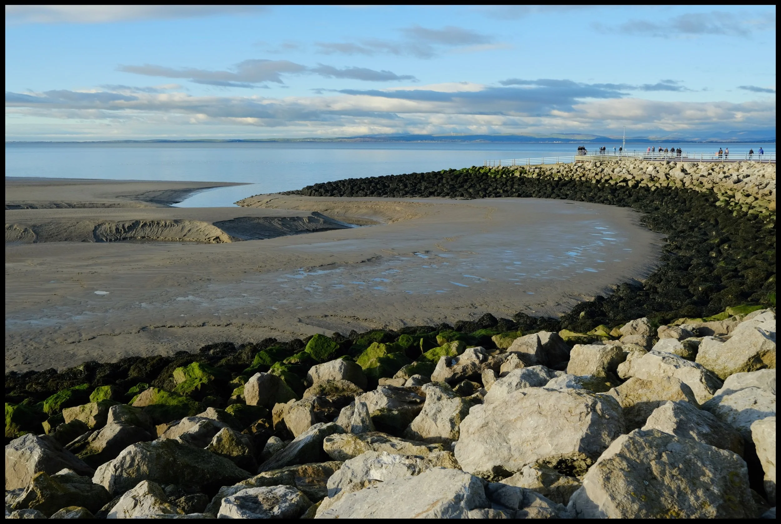
On this occasion, the tide was out as evidenced the large and seemingly endless expanse of sand and mudflats (one of the largest in Europe).
Soon we came across this fantastic sculpture, known as the Venus and Cupid (subtitled “Love, The Most Beautiful Of Absolute Disasters”). It was designed by Shane A. Johnstone in 2005.
Views for miles and miles, with some epic clouds to boot.
The people who live in these flats must enjoy some incredible Morecambe Bay sunsets.
A family carefully navigating around Morecambe’s beach pool. No doubt it will be frightfully cold.
Some braver souls than I ventured further out onto the sands. Just be careful of the quicksand…
Lone fishing boats rest lopsidedly in the sands, waiting for the tide to inevitably return.
Plenty of memorials can be found along the promenade in one form or another. Clearly a special place for many people.
Had to use some of these tide breakers as a leading line across the bay towards the Lake District fells.
We soon reach the more “touristy” part of Morecambe’s promenade. Kids playgrounds and B&Bs ahoy.
Near the clock tower one can find this metallic sculpture depicting the Lakeland fells across Morecambe Bay.
You can find some rather colourful and unusually shaped seafront buildings when strolling along the promenade.
Of course, no walk of Morecambe is complete without visiting the Eric Morecambe stature, now seasonally adorned with a Christmas hat and fluffy white beard.
Bringing sunshine to millions of people.
The clouds were looking a little dark, looking back towards Cumbria and North Yorkshire.
I love that some of the buildings in Morecambe still have their original signage.
More new signage that reflects Morecambe’s Art Deco past, complete with palm trees.
It’s rather beautifully done.
Near the Stone Jetty, I wandered around the front of the Midland Hotel to capture some ultra-wide compositions of the buildings curvature.
It’s a cracking building. Glad to see it restored to its former glory.
Around the other side of the hotel, I decided to shoot right into the sun and fully accept whatever weird and wonderful lens flares I got. In the end, not bad at all!
There are bird sculptures aplenty when you follow the Stone Jetty, such as these cool seagulls.
Love the design and layout of the Stone Jetty.
The sun was really starting to break out from the heavy winter clouds, casting long shadows that I couldn’t resist playing with.
One of my favourite bird sculptures found on the Stone Jetty, a rather depressed looking bird.
Near the terminus of the Stone Jetty, Lisabet and I spotted these mudbanks and their curves alongside the boulders. Had to line up a composition.
She’s a beaut.
Lunch was beckoning, but not before I nabbed a few more scenes along the Stone Jetty.
Remember what I said earlier about strange and unusual Morecambe buildings?
This is one of Morecambe’s prettier buildings, though; the Winter Gardens, originally built as the Victoria Pavilion Theatre in 1897.
Pre-sunset, some beautiful golden sunlight was casting beams across various buildings along Morecambe’s seafront. As well as documenting the weird and wonderful, I also wanted to capture the “other” side of Morecambe too.
Some places have existed along the Morecambe seafront for so long they’re practically institutions in their own right, such as the Old Pier Bookshop.
The light just got better and better, and we weren’t the only ones enjoying the scenes.
Another fantastic day.

Newton Point, Northumberland, Summer
Ah haar, there’s a sea fret rolling in.
Ah haar, there’s a sea fret rolling in.
Early on in our Northumberland break we fancied a hike around Embleton Bay, to shoot photos of the bay’s massive and smooth black basalt boulders with views towards the ruins of Dunstanburgh Castle.
However, plans change. As we neared the bay it became clear (or rather, it didn’t) that a “haar” or sea fret had rolled in off the North Sea, covering the whole Northumberland coastline in thick fog. There were no views to be had of the castle ruins.
Instead, we followed trail—known as St. Oswald’s Way—north, passing through the National Trust village of Low Newton-by-the-Sea towards Newton Point. We ventured with open eyes and mind, which was good because Newton Point was an absolute delight that we no idea about.
Additionally, the haar provided an atmospheric aura to some of my photos, which I’m happy to take.
All photos shot on my Fujifilm X-T2 using my three prime lenses: a Samyang 35mm f/1.2, a Laowa 9mm f/2.8, and an adapted Pentax 55mm f/2.0. Images made 80% in-camera using a customised Velvia film simulation, with minor edits and corrections afterwards in Lightroom and Affinity Photo.
After parking at Embleton, our hopes were high for wonderful scenes of Dunstanburgh Castle.
Alas, no castle could be seen. The haar had covered the whole Northumberland coastline in a thick fog. Nevertheless, to get to Embleton Bay and the trail from Embleton Village, you have to pass through Dunstanburgh Castle Golf Club. There’s a lot of golf around the Northumberland coast.
Above Embleton Bay, near the Embleton Links golf course, there’s a whole bunch of “beach chalets” or, more accurately, bungalows that sit on National Trust land. On a clear sunny day I’ve no doubt they look adorable and inviting. With the sea fret rolled in, the bungalows presented a more foreboding presence.
Spooky. Zombie film, anyone?
A way down to the sands of Embleton Bay, but my eye was caught by the people walking along the beach, appearing like ghosts as the haar rolled in off the sea.
We close in on the charming village of Low-Newton-by-the-Sea, an old fishing village now almost totally owned by the National Trust.
The village is known for its cream white cottages and open square, with the 18th-century Ship Inn pub right in the middle. A charming place.
North of the village we break away from St. Oswald’s Way and take the private road east towards the coastline, curious to see what was here.
What we found was a coastline of bloom flowers, lichen and moss, and volcanic black boulders everywhere. With the haar in place, the area appeared to me magical and surreal.
Clints and grikes of volcanic basalt rock provided lovely textures and lines for playing around with compositions.
With my ultra-wide 9mm lens, I was able to render some more unusual compositions around here by getting really low and intimate with some of the small channels carved into the rock.
Blossoming flowers and weeds everywhere gave me more opportunities for interesting photos.
The headland of Newton Point houses a former LORAN (long range navigation) station from the Cold War era. Spooky.
We followed the eastern edge of Newton Point around to its northern side, and then—BOOM. This view and these cliffs. We had no idea they were here.
Not massive cliffs by all means, but shapely and beautiful nevertheless.
Columns of dark volcanic basalt stand as a fortress against the unrelenting sea.
The North Sea around here was wonderfully clear and azure. This made it awfully tempting for Lisabet to go for a swim.
Grass and lichen provide gorgeous colour contrast against the azure water and blue fog.
Fantastic colours and views.
From Newton Point we dropped down to the beach northwards known, interestingly, as Football Hole.
The retreating tide left behind these following lines and curves that I had to make a composition of.
The dunes around Snook Point make for some lovely views. At this point the sun even threatened to break through the haar.
Sand dunes that seemingly go on forever…
A beautiful blossom of Geranium sanguineum, otherwise known as bloody crane’s-bill. Also the national flower of Northumberland!
On our way back, the haar was finally starting to burn off courtesy of the midday summer sun. In the distance, cows graze peaceful near a pond.
Bardsea, Cumbria, Spring
It’s time to say goodbye to our extended Easter break.
It’s time to say goodbye to our extended Easter break.
Not including everyday walks to and from local shops, we’ve managed to clock up nearly 39 miles or 62 km of hiking.
Today was slower. After shopping for food supplies and a quick coffee break, I made and put a ragù on the slow cooker, and then we ventured towards the Furness peninsula for a waltz around Bardsea beach.
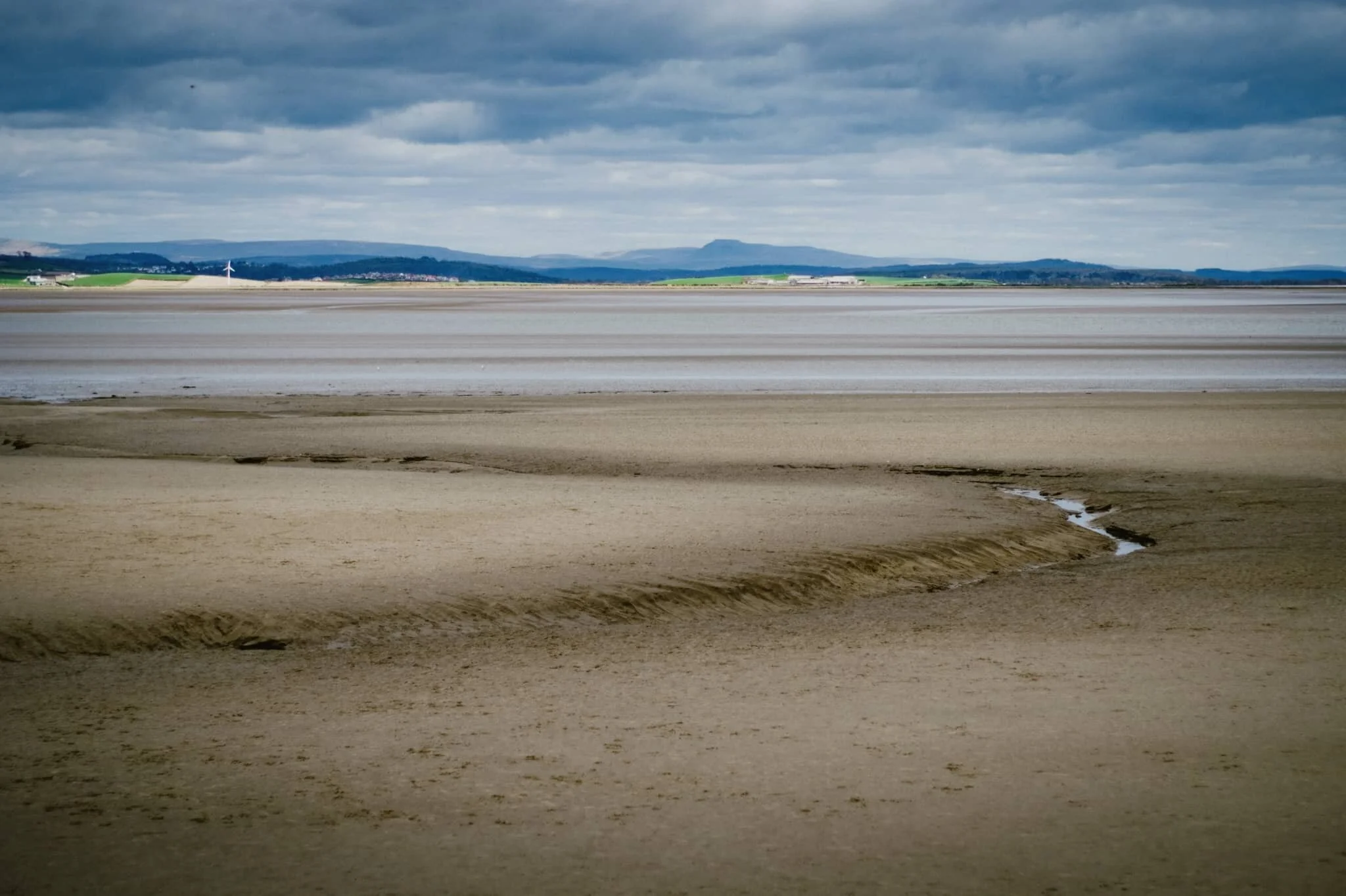
Bardsea beach offers extensive views of the Cartmel peninsula from its position at the outflow of the Levens Estuary, which ultimately joins Morecambe Bay. Much like Morecambe Bay, the coast of Bardsea is largely expansive sand and mudflats with seemingly unending panoramas. On our visit, conditions were clear enough to easily make out the Southern Lake District fells 22 km away and even Ingleborough in the Yorkshire Dales, 43 km away as the crow flies.
Throughout much of its history, Bardsea was a small farming and fishing village, accessible only by carefully crossing the sands of Morecambe Bay. The village also has historical ties with the Quaker movement as founder George Fox married the local landowner Margaret Fell.
Overall, a lovely way to cap off our extended Easter break.
All photos shot on my Fujifilm X-T2 using my three prime lenses: a Samyang 35mm f/1.2, a Laowa 9mm f/2.8, and an adapted Pentax SMC 55mm f/2.0. Developed using RNI’s Fuji Fortia SP film profile.
As a contrast to the consistently clear skies we’ve enjoyed this past week, today was overcast and deliciously moody.
The Southern Fells of the Lake District and the endless expanse of sand at the Levens Estuary.
Even in overcast conditions, you could clearly see Ingleborough (723 m/2,372 ft) from the beach, 43 km away in the Yorkshire Dales.
When the industrialisation of the Furness peninsula developed in the 19th-century, Bardsea became an important sea port. The remnants of all this activity now lies in ruins along the beach front.
I enjoyed the layering of this composition.
A small child, running freely across the sands of Bardsea beach.
When the tide is out, one can follow the many channels cut into the Levens Estuary.
Daffodils and other spring follows bloom in the small woods just off the beach.
Testament to Bardsea’s short-lived but intense period of serving the Furness peninsula as a sea port.