Arnside, Cumbria, Summer
I hope everyone had a lovely Summer Solstice.
I hope everyone had a lovely Summer Solstice.
When it comes to nature and the Summer Solstice, Lisabet and I are fortunate to have a variety of options on our doorstep. With a clear and cloudless evening ahead we decided on the expansive views offered at Arnside.
Arnside is a proper bonny seaside village located on the banks of the Kent Estuary, which eventually spills out into Morecambe Bay. Arnside features a ½ km long viaduct that carries trains across the estuary, and Arnside Tower; a peel tower, built in the 14th/15th century. Another curiosity is the Arnside Bore, a very fast rising tidal bore that occurs most high tides. People often watch the bore from the shoreline, marvelling at the faster-than-walking speed of the tide as Morecambe Bay refills the Kent Estuary every high tide.
For our evening, we just took a gentle meandering stroll along the shoreline of Arnside, enjoying the light and scenes as the sun set on the longest day of the year.
All photos taken on my Sony α7ii using my Sony FE 28–70mm f3.5–5.6 OSS zoom and Rokinon 14mm f2.8 ED AS IF UMC prime lenses. RAWs were developed in Lightroom, processed in Photomatix, and finalised in Photoshop.
Arnside, Cumbria, Summer by Ian Cylkowski is licensed under CC BY-NC-SA 4.0![]()
![]()
![]()
![]()
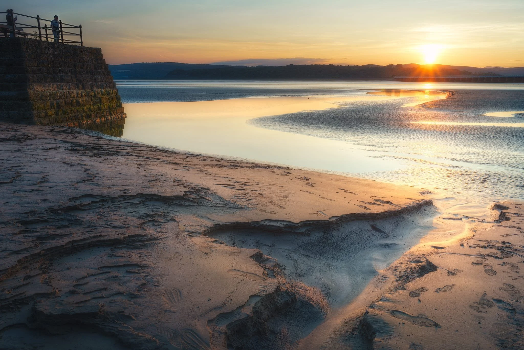
The gentle curves of the Arnside shoreline catches the golden sunset light, serving as a leading line towards the Arnside Viaduct and the distant Lake District fells beyond.
Probably my favourite shot of the evening. A small channel in the sand provides a nice leading line towards the sunset as onlookers from the pier enjoying the solstice.
Beached buoys provide a nice foreground subject as the sun gently sinks behind the fells.
A tighter composition focusing on this tidal channel as it reflects the fiery sunset light.
Back on the road, I equip my ultra-wide for this composition in the dying light of the day.
Did you enjoy these photos?

St. Bees, Cumbria, Winter
For our final full day of our mini-break, a trip to the coast was in order.
For our final full day of our mini-break, a trip to the coast was in order.
The weather forecast for the day had the fells of the Western Lake District blanketed in clouds. Instead, the westernmost point of Cumbria seemed like a good alternative.
St. Bees is a small village on the western coast of Cumbria. In comparison to the deep dales and high fells that characterise the Cumbrian landscape, most of Cumbria’s coastline consists of long sandy beaches, stretches of shingle, the occasional dune, and mudflats nearer Morecambe Bay. The exception to this rule lies at St. Bees, where St. Bees Head towers above the coastal village.
St. Bees Head is split into two sections: the South Head (which overlooks St. Bees village, and is known locally as the Tomlin), and the North Head. In between the two headlands is Fleswick Bay, accessible only by foot or sea. The small bay consists of deep shingle underfoot and towering sandstone cliffs in an array of otherworldly and seemingly impossible shapes and arrangements.
It’s been a good few years since we’ve hiked St. Bees Head, and it’s nice to reaffirm that our fitness has greatly improved since the last visit. St. Bees Head, and Fleswick Bay, did not disappoint.
All photos taken on my Fujifilm X-T2 using my three prime lenses: a Fujinon 23mm f/2.0, a Laowa 9mm f/2.8, and an adapted 55mm f/2.0. All images made in-camera using a custom Velvia-based recipe, finished for the web in Pixelmator and Darkroom.
Our destination for the day: St. Bees Head from the shore at St. Bees.

The views open up the minute you step on the cliff path. It’s fair to say that St. Bees Head has seen it’s fair share of erosion.
The cliff path reveals the extent of the St. Bees coastline. Much of the Cumbrian coastline is like this.
The first section up to the top of the South Head is quite the pull.
Yeah, that’s pretty steep. If the path were more wet and muddy, I’d have really struggled.
Thankfully it’s not long before the cliff path levels out, and gorgeous panoramas to St. Bees village and the Lakeland fells open up.

Near the old coastguard lookout, a fantastic view towards the headland’s sheer cliffs and Fleswick Bay beyond is possible. The path used to follow this cliff top quite closely, but erosion has meant the path has moved further inland.
To be safe, we stayed on the inland side of the path. The cliffs surrounding Fleswick Bay become more visible.
Despite the heavy cloud cover, the light conditions were being very cooperative.
Lots of gorse, Ulex europaeus, can be around the cliff tops of St. Bees Head. They’re not quite flowering yet, but those that have offered a nice composition as we neared Fleswick Bay.
The way down to Fleswick Bay nears.
Getting down to Fleswick Bay can be tricky. The path is often muddy, and the deep gill leading out to the bay is lined with moss-covered loose boulders. I did, dear reader, fall on my ass trying to get to the bay.
Our preservation paid off. This is Fleswick Bay and her incredible cliffs.
My lovely Lisabet, providing a sense of scale against the deep red jenga-like cliffs of Fleswick Bay.
It was time to fit my ultra-wide 9mm lens on to nab some expansive compositions of Fleswick Bay’s strange cliff textures.
Millennia of wave action have torn chunks off the cliff face, and smoothed out boulders.
Getting right low and underneath the cliffs with my ultra-wide lens provided some incredible angles.
Most of the sandstone cliffs are wet and constantly dripping water from the grass and soil above.
Our footprints are testament to how soft and deep the shingle goes. Really hard to walk in. We ventured as far out as we dared with the tide making its way in.
What now follows is a celebration of the weird and wonderful textures and patterns of Fleswick Bay’s sandstone cliffs.

This is the deep gill that flows out into Fleswick Bay.
And this is the reason why it’s quite hazardous to navigate your way back onto the cliff path.
But navigate we did. We were the only ones at Fleswick Bay this whole time. Everyone else seemed more interested in sticking to the cliff path.
One last look back at the cliffs of Fleswick Bay before making our way back to St. Bees.
Heading back to St. Bees, the light got better and better and I went on a shooting spree whilst it lasted. In the distance, a think bank of cloud sits on top of the Black Combe fells.
As the sun began its trajectory down into the sea, plenty of people will still heading up and down the cliffs of St. Bees Head.
St. Bees getting drenched in golden wintersun with the dark Muncaster Fells behind.
My lovely Lisabet, striding purposefully on towards St. Bees village as the sun bathed the land in light.

Elgol, Isle of Skye, Autumn
There’s something truly magical about the Elgol coast on Skye.
There’s something truly magical about the Elgol coast on Skye.
Firstly there’s the frankly ridiculous view you’re treated to as you descend the narrow winding road to the shore, which arguably is what makes most people fall in love with Elgol. I know that’s what it did to me, back in 2013, when I first explored this tiny coastal village.
But there is so much more to Elgol than the obvious view of the Black Cuillins across the sea. As you explore the coastline northwest, the pebbles give way to smooth boulders the size of a rugby ball, so you need to watch your step. And then the coastline dramatically changes as you’re greeted with a cliff that looks like a giant has bitten a chunk from its base.
The smooth rugby-ball boulders slide off revealing platforms and shelves and fins and ridges of seemingly impossible rock formations. A veritable playground of photo compositions.
My abilities with words can only do so much. Enjoy these sunrise photos of Elgol. I hope they express at least a small modicum of what I experienced here.
All photos shot on a Fujifilm X-T2 with both a Samyang 35mm f/1.2 and a Laowa 9mm f/2.8 lens using a customised Pro Negative Standard film profile.
This is the view one is treated to as you arrive at the main car park near the shore of Elgol. It’s just ridiculously stunning. As the sun was rising behind us it cast slivers of golden light, which caressed the Black Cuillins in a dazzling display.
I immediately picked my way towards the northwestern shore, looking for compositions featuring some of Elgol’s weird and wonderful rock formations. I found this stack of rock shelves, perhaps an Uncomformity, which I used as a leading line towards the glowing Black Cuillins (the particular member of the Black Cuillins pictured is Gars-bheinn, pronounced GAR-vein, meaning “rough mountain”).
On this occasion the tide was low, which exposed more formations for us to explore. Near the sea I found a jumbled mass of blocks haphazardly stacked on top of each other, and covered in barnacles.
I found this particularly large rock formation, about the size of a small car, all jagged and seemingly resting on the raised platform. Thousands of years of action from the sea has cut grooves into the raised bed, which I took advantage of for a composition.
I carefully circumnavigated this massive boulder that fascinated me, looking for angles and views.
The light and atmosphere were so clear that I was actually able to make photos looking west right across the sea towards the mountains on the Isle of Rùm, 20 km away.
More light started to hit the Black Cuillins as I took this composition, with the sea intruding and cutting a channel into the raised platforms.
Our day wasn’t finished with this sunrise shoot at Elgol. Stay tuned for more photos of our hike from Kilmarie to the isolated beach of Camasunary Bay!