
Feizor, Yorkshire Dales, Spring
I don’t explore the Yorkshire Dales enough.
I don’t explore the Yorkshire Dales enough.
After finally getting over my post-Skye mourning and depression period, it seemed like spring finally arrived in Northern England.
Aware of how busy the Lake District would be, we instead ventured east to the Yorkshire Dales. We quickly realised that we hadn’t explored the Feizor area of the Dales in a long time, like maybe 7-years or so. Time to fix that.
Feizor (pronounced “FAY-zer”) is a tiny l’al hamlet between Austwick and Settle, and easy to miss. Home to a few houses, a farm, and the famous Elaine’s Tearoom, rising high above the hamlet are the limestone fells of Pott Scar and Smearsett Scar. These were the focus of the day’s hike and exploration.
Pott Scar and Smearsett Scar were beautiful examples of limestone karst landscapes, but they also offered immense views to either the back of Ingleborough or the shapely Pen-y-ghent.
A super day.
All photos taken on my Sony α7ii using my Sony FE 28–70mm f3.5–5.6 OSS and Vivitar “Series 1” 70–210mm f2.8–4.0 zoom lenses. RAWs developed in Lightroom, then tweaked and finalised in Photoshop.
Feizor, Yorkshire Dales, Spring by Ian Cylkowski is licensed under CC BY-NC-SA 4.0![]()
![]()
![]()
![]()
A near-timeless scene in the heart of Feizor. Old stone buildings, dry stone walls, foliage everywhere, and the fells rising up behind.
This quaint scene, complete with old water pump, was something I couldn’t resist making a composition of.
Round the back of Pott Scar, before ascending, one can enjoy expansive views towards Pen-y-ghent, one of the Three Peaks of the Yorkshire Dales.
The squelchy slog up the fell was rewarded with beautiful views from Pott Scar towards Smearsett Scar.
Fin-like clints and grikes of limestone made for a nice leading line towards Smearsett Scar.
Nearer the edge of Pott Scar, I focus stacked these bare limestone edges as they curved off into the distance towards Smearsett Scar.
From the summit of Smearsett Scar, the full extent and shape of Pott Scar is revealed. The day was brightening up too, albeit with a haze.
The summit of Smearsett Scar offers a bounty of limestone clints and grikes that I want to make compositions of.
Another variation from the summit of Smearsett Scar, using the exposed clints and grikes as a leading line towards Pott Scar.
Back down the back of Pott Scar, drafting clouds cast dancing shadows across Moughton Scar and the back of mighty Ingleborough, another one of the Three Peaks of the Yorkshire Dales.
Plenty of teeny Swaledale lambs about, hastily retreating back to their mums as we followed the track back to Feizor.
The single road that winds its way through Feizor.
A super-zoomed in composition of the back of Ingleborough, taken from the small lane between Feizor and Buck Haw Brow, light dancing across the karst features of the land.
Did you enjoy these photos?
Buxton, High Peak, Derbyshire
Buxton. Spas. Spring water.
Buxton. Spas. Spring water.
A certainty on our itinerary when holidaying in the Peak District was to explore the historical spa town of Buxton.
Though almost slap-bang in the middle of the Peak District, Buxton isn’t actually in the National Park. Look…

Buxton, in the Peak District area
Image courtesy of VisitBuxton.co.uk.
This means Buxton has excellent links to other parts of the National Park.
Buxton has been inhabited since the Stone Age, but the first major development of the area came courtesy of the Romans. They named the settlement Aquae Arnemetiae, that is, "Baths of the grove goddess".
Various peoples throughout history have treasured Buxton for its natural geothermic spring, which constantly gushes water out at a steady 28ºC. The town grew in the 18th century due to the Dukes of Devonshire, but it was really in the Victorian era where Buxton drew the crowds. Touring Victorians were attracted to the reputed healing powers of the natural spring.
We enjoyed a long and pleasant meander around the town, on what turned out to be a wonderfully clear autumnal day. Buxton really showed off what it had to offer.
All photos taken on my Sony α7ii using my Sony FE 28–70mm f3.5–5.6 OSS zoom and Rokinon 14mm f2.8 ED AS IF UMC prime lenses. RAWs developed and edited in Lightroom for iPad using Digistock’s Ektar 100 profile.
Buxton, High Peak, Derbyshire by Ian Cylkowski is licensed under CC BY-NC-SA 4.0![]()
![]()
![]()
![]()
We first wandered around Buxton Park before entering the town proper. Beautiful autumn colours were really starting to pop all around the park. Geese were plentiful, too, and clearly very accustomed to humans.
A fellow tourist takes in the view across one of the many ponds and lakes in the park. In actuality, these ponds are all part of the River Wye, which was heavily landscaped in the 19th century.
The park and Pavilion Gardens were opened in 1871, designed by Edward Milner, a well-known landscape architect. He also developed three parks in Preston, Lancashire, amongst many others.
Another lovely English scene, full of ducks, meticulously maintained landscaping, and Victorian architecture.
Buxton Opera House was designed by Frank Matcham in 1903. It’s reportedly the highest opera house in the country. Matcham also designed several London theatres, including the London Palladium, the London Coliseum, and the Hackney Empire.
Buxton saw a decline as a spa resort in the early 20th century. The Opera House re-opened in 1979 with the launch of the Buxton Festival, and the town saw rejuvenation as a base for exploring the Peak District.
Part of the Pavilion Gardens is this 19th century conservatory. Originally, the building was used as a small concert hall, complete with organ. In 1982 it was remodelled as a greenhouse conservatory, with tropical plants and a fish pond.
The Conservatory now houses many beautiful plants, several of which are extremely rare to find anywhere else in the UK.
A visit of Buxton is not complete without checking out St. Ann’s Well and the Pump Room. The room was built in 1894 to dispense the well's water from taps for drinking. Now restored and managed as a Tourist Information Centre, I shot this 10-shot panorama to really take in the Victorian architecture.
Buxton Town Hall, opened in 1889, was designed in the style of a French château. It now houses the offices of High Peak Borough Council.
Around the corner from the Opera House, we found this wonderfully preserved piece of living history: a Victorian chemists’. The shop assistant even showed us a ledger they’ve kept of patients and their prescriptions all the way back to the Victorian times.
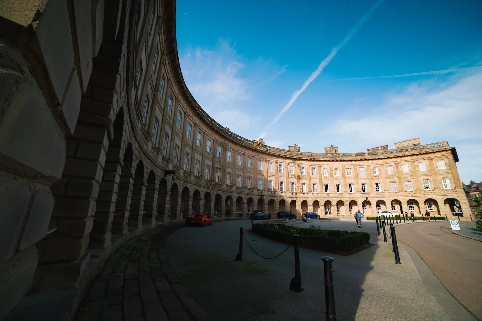
The crowning jewel of Buxton: the Crescent. It is often compared to the more famous Royal Crescent in Bath, but some argue that Buxton’s is “more richly decorated and altogether more complex”.
The Crescent was built in the late 18th century for the 5th Duke of Devonshire. His plan was to elevate Buxton into a popular Georgian spa town. It was built as a unified structure incorporating a hotel, five lodging houses, and a grand assembly room with a fine painted ceiling. By the mid-1980s the last part of the Crescent that was still functioning as a hotel closed due to the high cost of necessary repairs. Then, the whole building was closed when major structural problems were discovered in 1992.
What followed was a couple of decades of the building changing hands, fundraising for essential repairs and upgrades, and consulting on its future. Finally, in October 2020, Ensana reopened the hotel following 17 years of refurbishment.
Did you enjoy these photos?
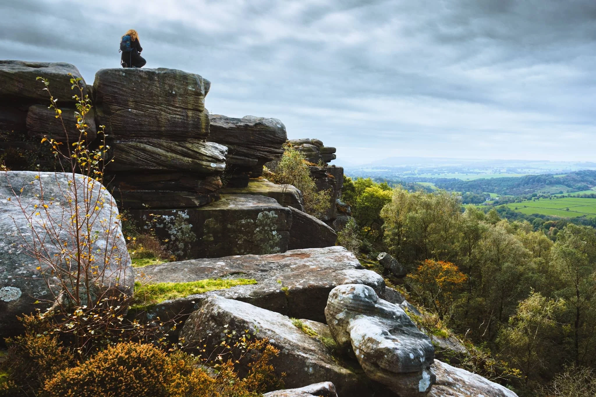
Stanage Edge, Peak District, Autumn
Perhaps the Peak District’s most famous edge.
Perhaps the Peak District’s most famous edge.
Froggatt Edge and Curbar Edge were epic enough. But further north, above the bonny village of Hathersage, one can find the massive 3.5-mile long Stanage Edge, which peaks at High Neb 458 m (1,503 ft).
Aside from the height and length of Stanage Edge, and its epic views plus incredible rock formations, the escarpment is famous for rock climbing. Any of the crags and rock walls are not particularly high, perhaps up to 25 m in height, but they are challenging and have been tackled extensively from the mid-20th century onwards.
Thankfully access to Stanage Edge is easy courtesy of numerous small, and free, carparks and road laybys. With the addition of high winds and ever-changing light, we enjoyed an epic hike along this most famous Dark Peak edge.
All photos taken on my Sony α7ii using my Sony FE 28–70mm f3.5–5.6 OSS zoom lens. RAWs developed and edited in Lightroom for iPad, with a little finalising help using Darkroom for iPad.
Stanage Edge, Peak District, Autumn by Ian Cylkowski is licensed under CC BY-NC-SA 4.0![]()
![]()
![]()
![]()
Upon ascending the trail from the off the road, the views immediately open up across the expansive moorland towards Over Owler Tor.
At the trig point 457 m/1,499 ft a. s. l., my Lisabet climbs up to capture those seemingly endless panoramas towards Edale and the Hope Valley.
Smoothed gritstone boulders line the way towards the trig point. Happily, cloud formations above endeavoured to provide another leading line to the trig point.
A drop between two walls provides a nice composition as the light explodes from the clouds, illuminating Over Owler Tor in the distance.
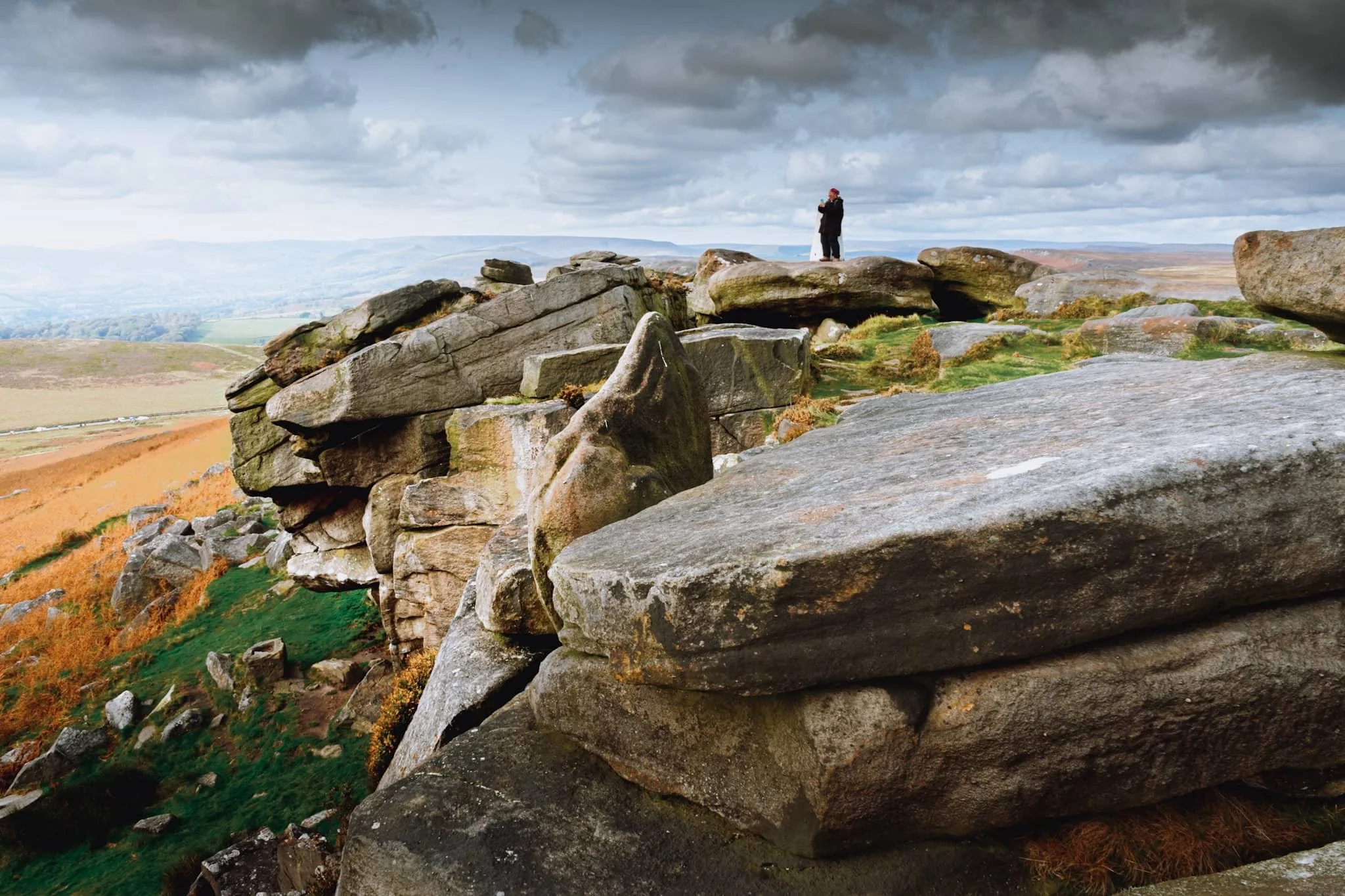
The sun almost completely out, I find a solitary boulder perched precariously on the edge of a gritstone platform.
I crept underneath an overhanging crag that provide me this lovely arrangement of boulders with a view towards Burbage Moor. Fighting the 50+ mph wind gusts, I carefully place the trail below the edge in between the boulders and the crag for a clean leading line.
Further north along Stanage Edge I found a few large gritstone boulders, beautifully smoothed and carved by millennia of erosion. They put me in mind of tortoise shells.
A set of beautifully smooth boulders huddle together against the powerful winds. In the distance, you can just make out Hope Valley with Mam Tor and the Great Ridge rising above.
Lisabet enjoyed making me nervous by standing perilously close to the edge of several severe drops. They did, however, make for excellent photos.
Below Stanage Edge the sharp drop down gives way to miles of fern and bracken, now displaying their rusty autumnal hues as they creep up the escarpment wall.
This was about as close to the edge as I dared, in order to nab a composition with these rock formations, like piles of messily stacked CDs.
Above Hook’s Car, the drop from Stanage Edge is more vertiginous and clearly an area where rock climbers like to upgrade their skills. People to the bottom-left of the image and on top of the edge to the right show the scale of the place.
This was a particularly popular climbing section, with one climber recently ascending to the top of the edge and victoriously pulling up his rope.
From here, it’s actually possible to make out where the White Peak limestone of the Hope Valley gives way to the eastern Dark Peak gritstone.
There were a few of these boulder bridges spanning across gaps that provided lovely little “portal” style compositions to play around with.
Dark Peak landscapes aren’t really known for their caves, like the White Peak is, but there’s a famous one on Stanage Edge: Robin Hood’s Cave, pictured here with people enjoying the shelter and relief from the wind. Did Robin Hood ever rest in this cave? Who knows?
One of my favourite shots from the day, showing the sheer vertical drop down from Stanage Edge, and the full extent of its length into the distance.
Two pillars of gritstone stacks provide another “portal” composition looking across the moorland towards the Peak District’s limestone plateau.
A wider composition, with Stanage Edge continuing on into the distance on the right. In the middle, Bamford Moor gives way to the rolling hills above Derwent Reservoir.
We located one of the main trails down the escarpment and back towards the road. About halfway down, I couldn’t escape this arresting composition. Miles of rusty ferns with Stanage Edge and clouds above.
Did you enjoy these photos?
Dovedale, Peak District, Autumn
From the Dark Peak to the White.
From the Dark Peak to the White.
In my last post, I talked about how the Peak District can be broadly split into two areas: the Dark Peak and White Peak. They reflect the predominant underlying geology: gritstone for the Dark Peak, and limestone for the White Peak.
After exploring the Dark Peak’s Froggatt and Curbar Edges, it was time to navigate the deep valley of Dovedale in the White Peak.
Dovedale is a particularly famous area in the Peak District—and the UK in general—seeing around 1 million tourists a year. It features stepping stones, rocky spires, craggy hills, and caves.
We elected to hike the full route, south to north, from the main car park to Milldale and back. In my view, Dovedale exceeded spectations.
All photos shot on my Sony α7ii using my Sony FE 28–70mm f3.5–5.6 OSS zoom and Rokinon 14mm f2.8 ED AS IF UMC prime lenses. RAWs were developed and edited in Lightroom for iPad, and finalised with the help of Darkroom for iPad.
Dovedale, Peak District, Autumn by Ian Cylkowski is licensed under CC BY-NC-SA 4.0![]()
![]()
![]()
![]()
Upon entering the valley, it became immediately apparent how steep and craggy the valley sides were.
Arguably Dovedale’s most recognisable landmark, the stepping stones. Used to cross the River Dove and continue up the valley. This photo was unfortunately timed. I waited for this composition, looking for someone to cross the river to provide context for the photo. Instead, I managed to snap the moment just before this poor gentleman fell into the river. He wasn’t hurt, thankfully, and was quickly helped out.
Further into Dovedale and glorious autumn colours revealed their hues in the woods of the valley.
The first tastes of what was to come. This limestone spire is part of the Tissington Spires that line the eastern side of the valley past Lover’s Leap.
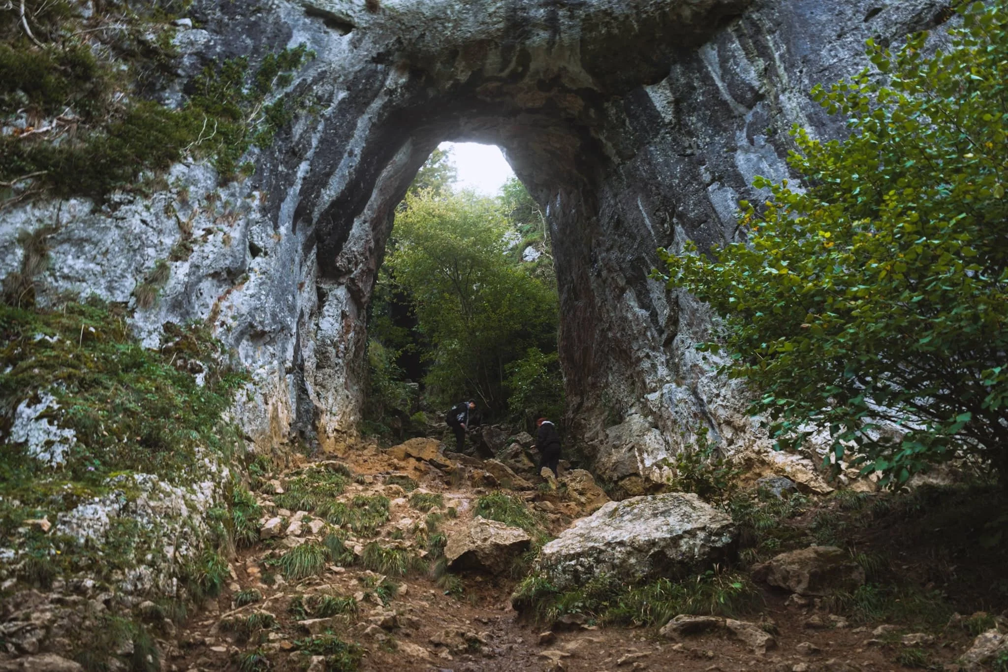
We paid particular attention to finding this spot, and were not disappointed. Beyond Tissington Spires an inconspicuous trail branches off the main valley footpath. It climbs up the steep valley side, revealing this monumental scene: a limestone archway, beyond which is Reynard’s Cave. A stupendous scene.
Beyond Raynard’s Cave, Dovedale narrows and deepens further into an area known as the Straits. Passage is possible only via a raised boarded trail. Once off the boards, we noticed a small cave with a clear and tempting stream trickling out of it.
The most accessible, and driest, caves in Dovedale are the Dove Holes, pictured here high above the trail.
Another solitary limestone spire pierces the sky above the woods.
The Dove Holes caves. They were formed during the last two ice ages by glacial water erosion. The caves became dry as the meltwater and river cut deeper into the gorge.
I got closer to the caves with my ultra-wide angle lens attached. It’s easy to imagine various ancient peoples and cultures have used these caves as shelter and storage.
The other, bigger, cave of Dove Holes, separated by a spire.
At Milldale, we paused for lunch and took the opportunity to wander around this bonny little village.
Milldale probably got its name from the corn mill that once stood on the River Dove here. Nowadays, it’s a sleepy little village with old stone cottages. Proper lovely.
After lunch it was time to take the return trip back down south the valley. This scene very much put me in mind of something like Yosemite.
One of the more famous spires in Dovedale can be seen on the right: Ilam Rock. Facing it is Pickering Tor. Ilam Rock rises 80 ft high from the valley floor, and is an impressive sight from any angle.
Near the Tissington Spires, Jacob’s Ladder rises above the woodland and catches the late afternoon light.
From below, the Tissington Spires are an imposing sight. Here they catch the golden afternoon light as the valley floor recedes into cold shadow.
Nearing the stepping stones once again, Dovedale’s most famous peak—Thorpe Cloud—comes into view. Here I took two exposures: one with my thumb covering the sun and one unobstructed. Blocking the sun with my thumb allowed me to blend the exposures with minimal lens flare.
Thorpe Cloud is an impressive pyramidal peak from across the River Dove.
One final look back into Dovedale before exiting for the day. An absolutely spectacular place.
Did you enjoy these photos?
Froggatt and Curbar Edges, Peak District, Autumn
If there’s one thing that the Peak District has a lot of, it’s Edges.
If there’s one thing that the Peak District has a lot of, it’s Edges.
The Peak District can roughly be divided into two areas: the White Peak, and the Dark Peak. The naming is based on the underlying geology: the White Park is limestone, and the Dark Peak is gritstone.
You’ll find the Peak District’s edges exclusively in the Dark Peak, particularly the eastern part of the National Park. From below, they appear has formidable walls and cliffs with fantastical rock formations and crags. Beyond those crags usually lies acres of boggy moorland.
On this particular occasion, we decided to explore every nook and cranny of two of the more famous edges: Froggatt Edge and Curbar Edge. They form a near-continuous route, north to south.
The day was bright, much cooler, and clear, save for the creeping clouds that gradually covered the sun as the day went on. Nevertheless, the scenes were absolutely sublime.
All photos taken on my Sony a7ii using my Sony FE 28–70mm f3.5–5.6 OSS and Vivitar “Series 1” 70–210mm f2.8–4.0 zoom lenses. RAWs developed and edited in Lightroom for iPad, finalised in Darkroom for iPad.
Froggatt & Curbar Edges, Peak District, Autumn by Ian Cylkowski is licensed under CC BY-NC-SA 4.0![]()
![]()
![]()
![]()
Starting from the north, the first part of the walk involves a beautiful woodland, Froggatt Woods, full of silver birch and autumnal ferns.
Emerging out of the woods, the views quickly open up and we find our first clump of gritstone boulders to climb around. Lisabet immediately hopped on one for a better view.
Already my excitement levels build as a veritable playground of compositions and rock formations present themselves to me.
A smooth nook in this boulder provided a nice foreground composition, with other crags forming a lead line towards the distant Upper Derwent Valley.
Lisabet’s woodland elf-like abilities means she easily clambers up to the highest boulder to nab those special photos. For me, her slight frame provides wonderful context for the scene.
An isolated pillar of a crag, whipped into otherworldly shapes by millennia or wind and rain, provides a lovely subject for this composition of heather, tors, and across the valley.
Navigating through the various crags and boulders, a little gap catches my eye. As peep through it, a sheer cliff wall down to the valley floor makes my stomach grip. And of course, I snap a photo to convey this sudden drop.
There’s not much separation between Froggatt and Curbar Edge. However, the drop from Curbar Edge is even more severe. This gap between two walls of gritstone provides a lovely leading line towards Baslow Edge in the distance.
Clambering on top of the some of the crags, these beautifully smoothed boulders with deep fissures provide a paradise of compositions, which I line up with Baslow Edge far away.
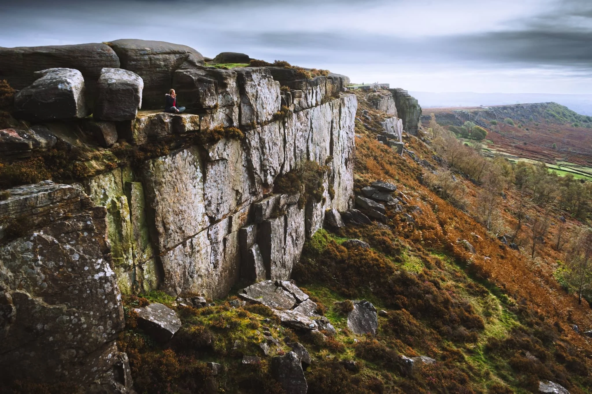
The staggeringly sheer drop down from the top of Curbar Edge is a sensation I’ll never forget.
This was about as close as I dared to the edge of the precipitous fall to the valley bottom from Curbar Edge.
A stronger burst of sun pulls out all the detail and texture in these windshaped crags.
The amount of heather up on Curbar and Froggatt Edge makes me realise that I need to come back here in late summer, when the heather’s vibrant magenta flowers will carpet the landscape.
Two neighbouring boulders, blasted by wind and rain for millennia, give another gorgeous composition to shoot as stronger sunlight emerges.
Quarrying has occurred on the Peak District’s various edges for centuries. The hard-wearing gritstone made for great millstones, used to grind grain like oats, barley and rye or other feedstuffs.
A lady rests in a nook on Curbar Edge, taking in the panoramic views whilst talking on her phone. She gave the scene a wonderful sense of context and scale that I couldn’t ignore.
Another isolated pinnacle of gritstone catches my eye. As the sun emerges again from the clouds, I line up this composition, using the various boulders to point a zigzagging route to the pinnacle.
Great slabs of gritstone with fissures and covered in lichen allow me to draw another composition looking north as the sun bathes the scene.
After we stopped from lunch using a boulder as shelter, we head back north along the trail. I equip my longer 70–210 mm lens to try and nail some zoomed in, tighter compositions. Here, from the edge, I zoom in on Stony Middleton nestled in its deep limestone gorge.
I enjoyed zooming in on the fell side as it caught the light; the land neatly divided by drystone walls, as a contrast to the pillars of rough gritstone.
Did you enjoy these photos?
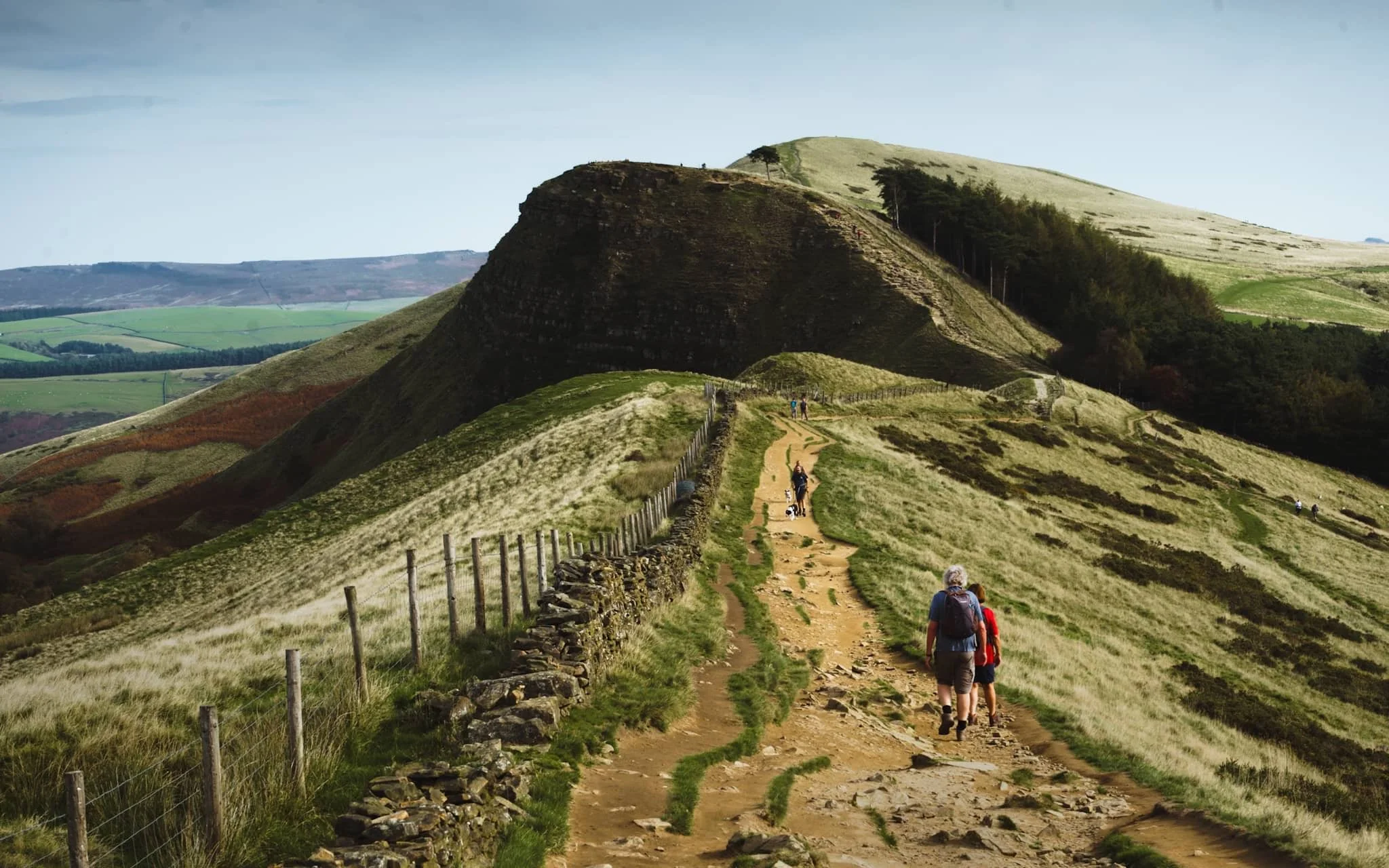
Winnats Pass & Mam Tor, Peak District, Autumn
Time to revisit more familiar areas.
Time to revisit more familiar areas.
Last time we attempted to explore Winnats Pass and Mam Tor was way back in May 2015. Back then I was considerably heavier and unfit. Since then I’ve lost a lot of weight and gained fitness. It would be interesting to see how I would fare tackling these locations compared to last time.
Our day started in bonny Castleton, heading west to the foot of Winnats Pass and hiking up the pass alongside the road, a 20% gradient uphill. After reaching the top, we would then continue up the moorland to locate the Mam Tor trail. Then it’s simple enough to follow the path to the summit, along the Great Ridge and then down the valley to Castleton.
Though the tops were windier than in the past few days, it was still unreasonably hot for an October day, pushing 21ºC. In any case, the light was compliant and the views were astounding.
All photos taken on my Sony α7ii using my Sony FE 28–70mm f3.5–5.6 OSS zoom lens. RAWs were developed in Lightroom for iPad, finalised in Darkroom for iPad.
Winnats Pass & Mam Tor, Peak District, Autumn by Ian Cylkowski is licensed under CC BY-NC-SA 4.0![]()
![]()
![]()
![]()
The impressive limestone crags above Winnats Pass dominate the skyline as you make your way up.
Looking back down Winnats Pass from roughly halfway up, the sun starting to rise above the gorge walls.
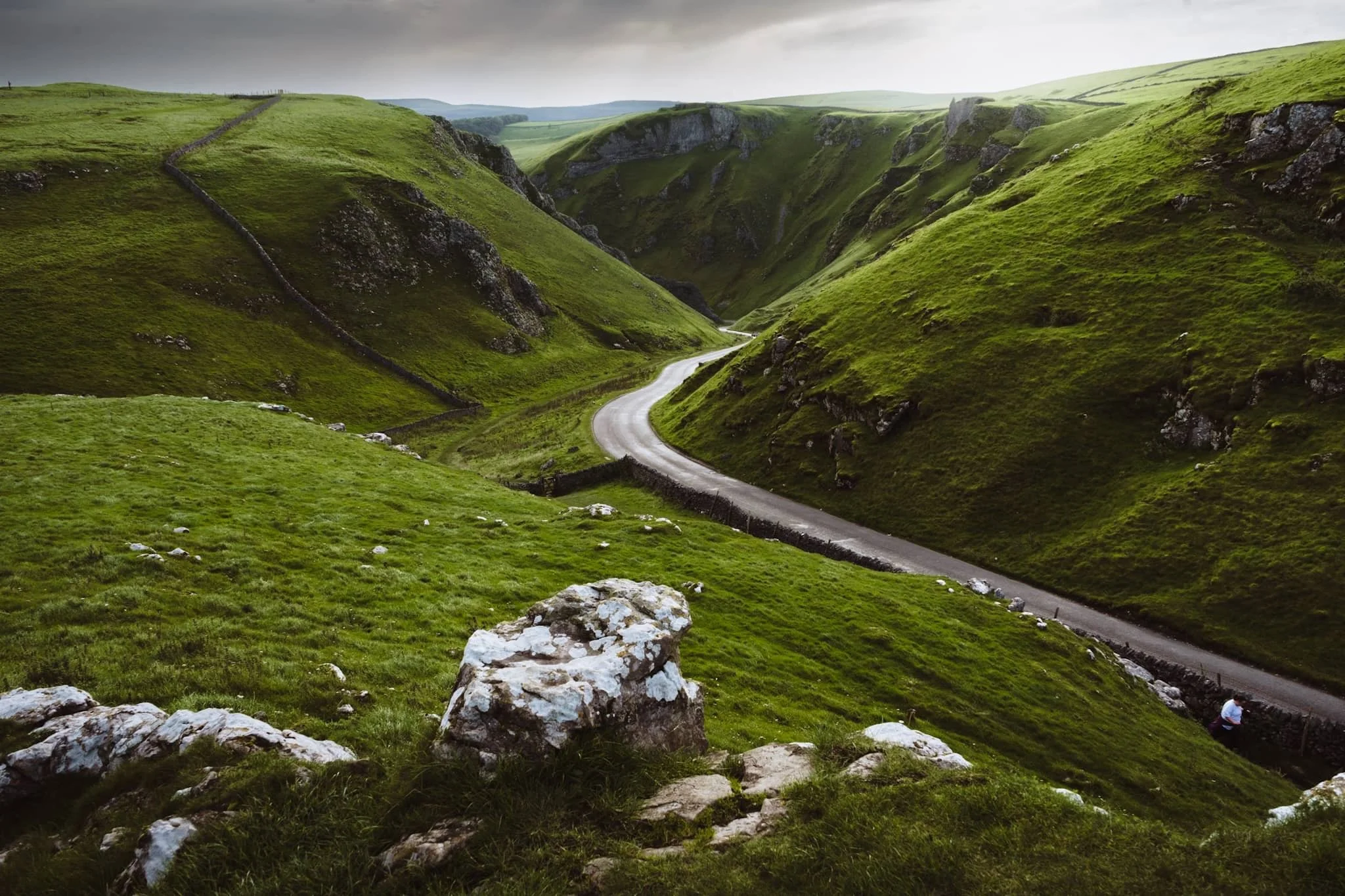
We found an isolated crag that gave us a solid composition looking down the pass. The name “Winnats” is a corruption over time of the original name “Wind Gates” Pass, due to the howling winds that funnel through the gorge.
From the top of the pass, it was easy enough to head up the moorland and locate the Mam Tor trail. Even just climbing up the trail a little bit, the views back down to Rushup Edge are already superb.
Around the shoulder of Mam Tor, the views towards Edale and Kinder Scout above are stunning. Aided, in part, by the winding road as a lovely leading line.
On the way up Mam Tor, the view back towards Winnats Pass reveals the dramatic drop of the gorge. It was once believed to be a giant collapsed cave, but evidence suggests it formed around an underwater canyon. Over time, other rocks covered this area. Much later, erosion revealed the pass we see today, shaped by melting water finding weak points in the rock.
As we climb higher, I find a sheep on the shoulder of Mam Tor, seemingly enjoying the views towards Edale.
Beyond the summit of Mam Tor, at 517 m / 1,696 ft above sea level, our next goal was clear in front of us: Hollin’s Cross and Back Tor along the Great Ridge.
Near Hollin’s Cross, fellow hikers rest and take the time to enjoy the extensive panoramic views across Edale.
Looking back along the ridge from Hollin’s Cross reveals profile of Mam Tor. The hill is also known as Shivering Hill, as its southeastern face near-constantly sheds rocks and causes landslips. In fact a long-established road underneath this side of Mam Tor, the A625, was abandoned in 1979 due to the constant need to repair the road after landslides.
Beyond Hollin’s Cross, our next destination was unmistakeable: the hulking crag of Back Tor.
Back Tor has similar geology to Mam Tor, and as such what you see is the result of a large shale landslip that falls dramatically down to the valley floor of Edale.
After falling on my arse a few times navigating the muddy trail down from the Great Ridge (and getting punctured by gorse on both occasions), I’m relieved to finally locate a paved country lane. Happily, it was also a nice composition to record.
From almost everywhere in Castleton, the towering crags of Winnats Pass are never far away.
Friends enjoy a pint outside the Bulls Head, whilst Mam Tor’s southeastern face rises clearly in the distance.