Hayeswater, Lake District, Summer
Here’s one we’ve not been to in quite some time.
Here’s one we’ve not been to in quite some time.
After June’s dry conditions and soaring temperatures, July has been unseasonably cool, stormy, and wet.
A succession of wet weekends exhausted our patience, so Lisabet and I braved the Sunday and head into the Lake District.
The initial plan was for a valley bottom walk around Grisedale, one of my favourite places in all the Lake District. However, as we approached Brothers Water, Lisabet suggested revisiting Hayeswater instead, and I heartily agreed.
The last, and only, time hiked up to Hayeswater was way back in June 2013. A lot has changed in a decade. For a start, despite being 10-years older, we’re both fitter. The hike up to the former reservoir was considerably easier than we remembered it.
Our journey into Hartsop and up to Hayeswater was punctuated with frequent downpours and brief bursts of localised light. It made the going tough, but boy did it make for epic photos.
All photos taken on my Sony α7ii with a Sony FE 28–70mm f3.5–5.6 OSS zoom lens. RAWs were developed and edited using RNI Films’ Kodachrome film emulations.
Hayeswater, Lake District, Summer by Ian Cylkowski is licensed under CC BY-NC-SA 4.0![]()
![]()
![]()
![]()
From Cow Bridge car park, Hartsop Dodd (618 m/2,028 ft) towers over you as you head towards the sleepy little hamlet of Hartsop.
Looking up Patterdale, another squall drenches Place Fell.
After passing through Hartsop, we’re greeted with this view of Gray Crag (699 m/2,293 ft) whilst a small flock of Swaledales eagerly keep their distance from us.
Looking up Pasture Bottom towards Threshthwaite Cove as a small gap in the cloud cover lets some light in.
Beyond Hartsop, the trail quickly gains height, opening up the views back across Patterdale to the Fairfield and Helvellyn fells.
Another big squall soon drenches the Patterdale fells. It would be our turn soon.
With the steeper part of the trail behind us, a brief pause allows me to compose this image of Lisabet heading onwards with Sulphury Gill streaming down the fellside and The Knott (739 m/2,425 ft) rising sharply above.
The ascension ceases. At Hayeswater, I zoom in on the sheer face of High Street (828 m/2,717 ft) as clouds blow across.
Hayeswater is natural in origin, but was dammed in 1908 to supply water for Penrith. In 2005 it ceased to be used as a reservoir, and in the summer of 2014 United Utilities removed the dam, restoring the natural form of the tarn.
We watched as waves of clouds washed across the fell tops.
After stopping for lunch in the pouring rain, we started making our way back down the trail. 250 yds from the tarn, a new bridge crosses the gill that allowed for some nice compositions.
The waves of rain eased off and soon the immense views across Patterdale to the Helvellyn fells revealed themselves to us. To the bottom-right of the image you can see the old Filter House, now a private residence.
Glad to vaguely dry, I started to relax as we made our way down the trail. Beyond, the cloud cover lifted from the fells.
A break in the cloud illuminated the fells, if only for a moment, and I was able to capture this epic scene.
Nearing the valley bottom, the shoulder of Hartsop Dodd is bathed in glorious golden light.
A tighter, zoomed in composition involving a drystone wall, pasture field, and Raven Crag.
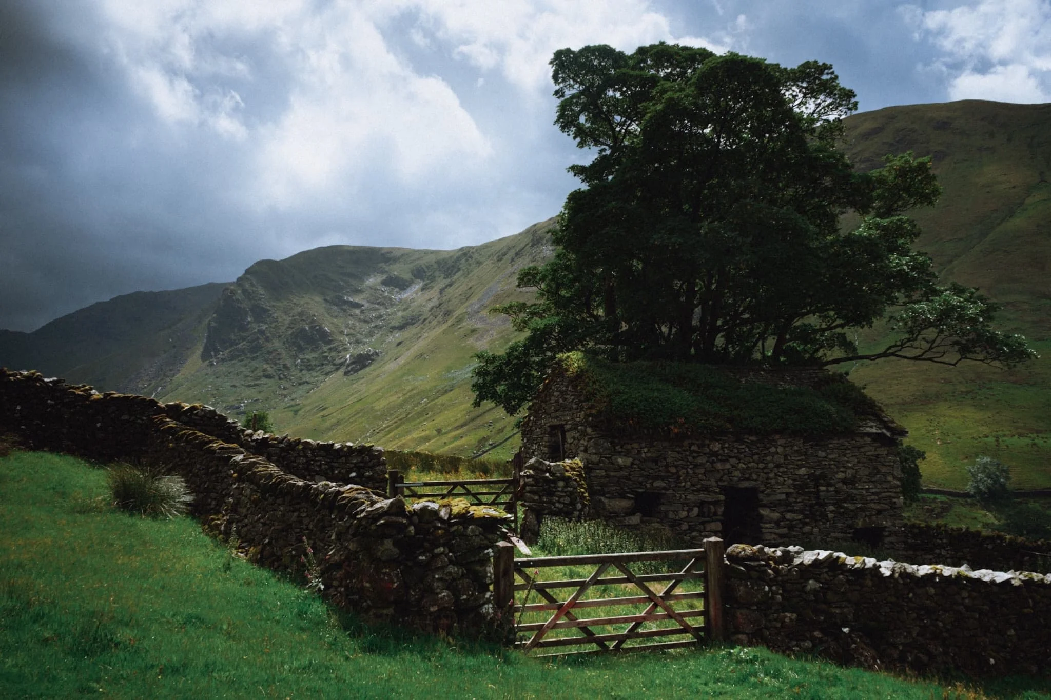
Beneath the towering form of Hartsop Dodd, this delightful barn captures our attention and imagination.
A beautiful scene of one of Hartsop’s houses with Hartsop Dodd looming above.
Perhaps the finest shot I got from the whole day. A dilapidated barn covered in a carpet of moss with a tree growing out of it. Beyond, a break in the clouds allows an intense burst of light to illuminate Raven Crag.
A true rural Lake District scene with the unmistakeable form of Hartsop Dodd keeping watch. The sky darkens as the clouds drop down and close in again.
We tried a different route back to the car park, passing by this gorgeous cottage as another wet squall starts to close the end of our walk.
Did you enjoy these photos?

Paddy’s Lane, Cumbria, Summer
2022 has got more twists and turns than a goat’s intestines.
2022 has got more twists and turns than a goat’s intestines.
This isn’t the place to rant. Suffice it to say, it’s been a super frustrating year. Thankfully, I have had a small nugget of personal positive news, which I’ll clutch tightly to my chest and use as a shield for whatever 2022 has next for me.
As it’s summer in Cumbria that means it’s sunny as well as rainy. Over the weekend I had some time to enjoy a local hike from Kendal up to Paddy’s Lane via Old Sedbergh Road. The clouds and conditions were pretty epic on the way up; unfortunately I got caught out on the way down and got pretty soaked.
Managed to keep the new lens dry, though. And thankfully, the Fujifilm X-T2 is weather sealed.
All photos taken on my Fujifilm X-T2 using a Vivitar “Series 1” 28–105 mm f/2.8–3.8 lens. Developed in Lightroom, finished off in Affinity Photo.
Now that the Queen’s Platinum Jubilee celebrations are over, Kendal Town Hall has re-erected the Ukrainian flag above the town.
These houses along Thorny Hill always put me in mind of Harrogate.
Underneath the railway line and onwards to Old Sedbergh Road.
With all the intermittent periods of rain + sun + rain + sun, I imagine this fella’s got his work cut out on his allotment.
Heading up Old Sedbergh Road, I spy three alpacas happily grazing in the fields.
Looking back at the route I took, the light still good. This wouldn’t last long. Look at those clouds above Kendal Fell…
As I climb the Lake District fells reveal themselves. It’s all looking a bit brooding and foreboding.
A final blast of sun before the storm clouds really close in.
The distant fells start to get hazy as the approaching rain saturates them.
Hoo boy, that’s the direction I’m heading in, too. Looks like I’m gunna get drenched…
Other people had timed it well and were already on their back down into the town.
I took the opportunity to nab some proper stormy images before the rain blew across the Kendal valley towards my position.
The dog walkers ahead quickly donned their hoodies as the gentle pitter-patter of rain started to fall.
As the rain got heavier I took shelter underneath a thick pair of trees and decided to wait things out. Whilst I did, I snagged this composition of the road onwards.
Eventually I made it back to town and the rain let up for long enough that I could snap a pic of this magnificent and ancient building.
Did you like these photos?

Kendal (Post-Eunice), Cumbria, Winter
The day after Storm Eunice.
The day after Storm Eunice.
Evenings and weekends have been frustratingly wet and stormy in February, which has meant that I’ve not been able to get out into nature as much as I’d like. This culminated in the week commencing 14th February, which saw two named storms passing over the British Isles: Storm Dudley and Storm Eunice.
Storm Dudley struck first, from Wednesday 16th to Thursday 17th. It brought 80 mph winds and heavy rain to Wales and parts of Northern England and Scotland. Following Dudley, Storm Eunice arrived Friday 18th to Saturday 19th, with even stronger winds of up to 122 mph, and a rare Red Alert (danger to life) issued for the South West and South East of England. Videos across social media soon emerged of trees being ripped up from their long-held roots, power lines collapsing, wind turbines disintegrating, and even the O2 Arena having its roof shredded apart. Unfortunately, lives were lost, too.
This 2021–2022 storm season has reportedly seen more than 8 million trees destroyed.
By Saturday afternoon conditions started to calm down once more, and the sun soon came out. So, armed with my camera, I gingerly ventured out for a hike around my town, Kendal, to get some high vantage points and survey the damage.
All photos taken on my Fujifilm X-T2 with a Fujinon 23mm f/2.0 prime lens. Developed in Lightroom and finished in Affinity Photo.
It was nice to actually see the sun come out for once.
I decided to head up onto Castle Howe, the site of Kendal’s first castle. To do that, you need to turn onto Allhallows Lane then up one of Kendal’s steepest roads, Beast Banks.
Even following two life-threatening storms, people are still more than ready to head out for a spot of retail therapy.
About a ⅓ of the way of Beast Banks you can exit onto Garth Head, an ancient medieval lane connecting two steep streets, Beast Banks and Captain French Lane. It’s technically an unclassified highway—the U752—making its upkeep the responsibility of Cumbria County Council.
About halfway along Garth Heads a couple of footpaths branch off and head up the fellside. This is the way to Castle Howe, the site of Kendal’s first castle. Nowt remains of the castle now except an obelisk that marks the castle’s original location. The castle was built somewhere around the end of the 11th century or turn of the 12th century.

The obelisk that marks the site of Kendal’s first castle, Castle Howe.
What the land around Castle Howe does offer is a fantastic view across Kendal town all the way to Benson Knott and the Whinfell fells.
One of my favourite lanes in Kendal, and certainly one of the steepest.
From Low Fellside the view spreads out more. The Whinfell fells and the Howgills are covered in a fresh coating of snow.

Above Maudes Meadow Residential Care Home, the rabbits were happily munching and frolicking on the common.
Storm Arwen destroyed many trees around Maudes Meadow. Thankfully, Dudley and Eunice didn’t add to the casualty list.
The River Kent, too, appears to have returned to normal levels.
Scout Scar, New Year’s Day, Lake District, Winter
Happy New Year everyone! Here’s to a joyous and—hopefully—more globally positive 2022.
Happy New Year everyone! Here’s to a joyous and—hopefully—more globally positive 2022.
The weather has been… weird. In fact, the UK set a new temperature record for New Year’s Eve, reaching as high as 16.5ºC. That is uncharacteristically warm. Temperatures maintained their elevated levels on New Year’s Day, too, but high winds also arrived. After a decent lie in, Lisabet and I decided on a local favourite to enjoy the first day of the new year: Scout Scar.
The last time we went up Scout Scar was almost exactly a month ago, and conditions could not have been more different. For New Year’s Day we took the time-honoured route up Captain French Lane and onto Brigsteer Road, following that all the way to the back of Scout Scar. Then, it’s a simple exercise of following the trail up the gentle slope of Scout Scar all the way until you reach it’s precipitous drop down to the Lyth Valley.
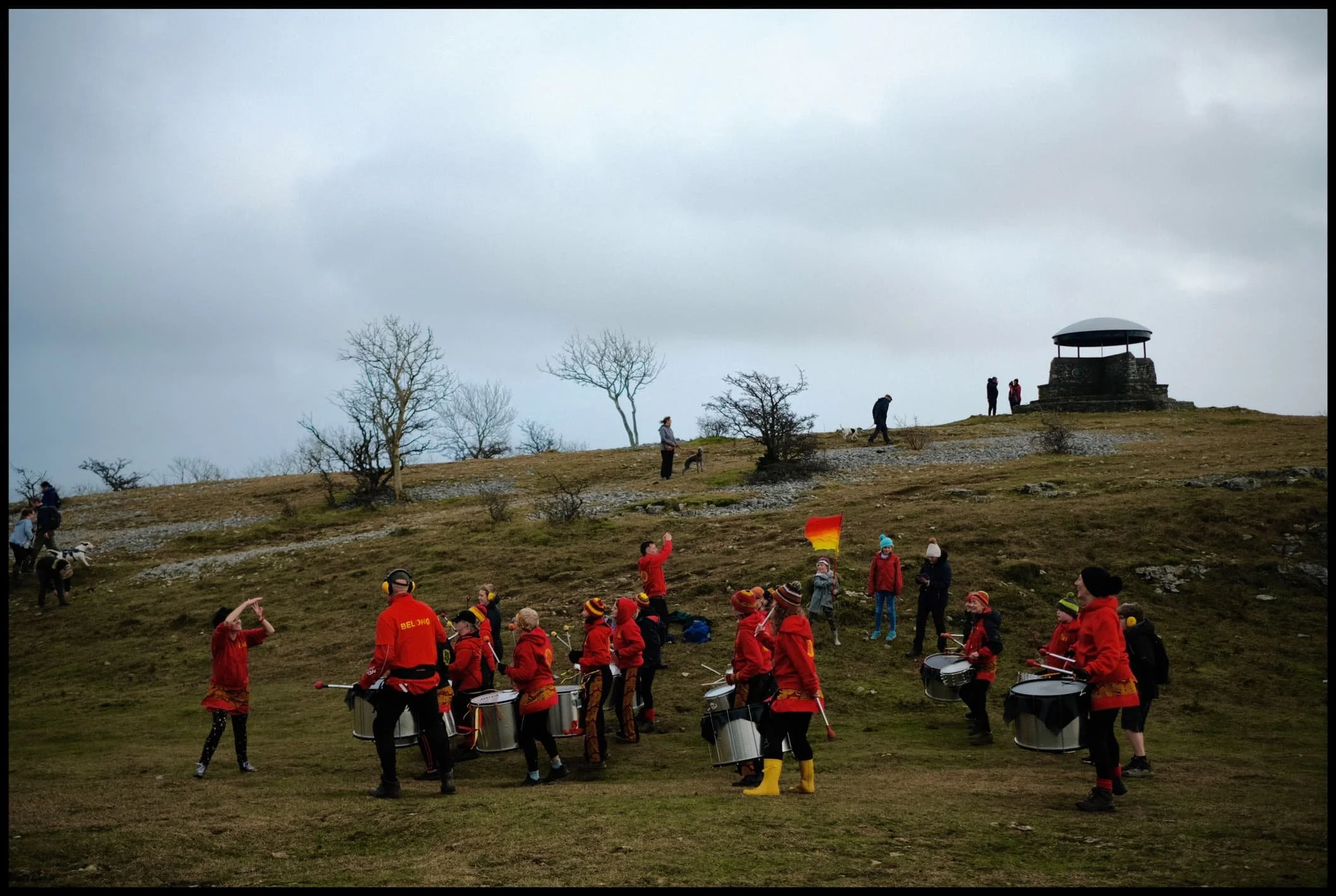
The wind was roaring all around us and views were obscured by haze and low cloud covering the Lake District fells. However, the sun was trying its hardest to burst out in between the rushing clouds. There were other sounds that were less familiar as we approached the summit… more rhythmical, and human. Turns out that Drum Nation Kendal had arrived at the summit for a joyous New Year’s Day drum performance on the fell.
Unexpected? Absolutely. But very awesome.
All photos taken on my Fujifilm X-T2 using two of my prime lenses: a Fujinon 23mm f/2.0 and an adapted Pentax SMC 55mm f/2.0. All images made in-camera using a customised Classic Chrome recipe, with finalisations made in Apple Photos, Pixelmator, and Darkroom.
Heading up one of the steeper roads in Kendal, Captain French Lane.
Crossing over the A591 via Brigsteer Road, cars struggling to drive straight in the powerful crosswinds.
Looking back to Kendal, and you barely make out the slopes of Benson Knott, Kendal’s most prominent fell.
The Scout Scar landscape is one of limestone and sparse clusters of small trees.
Plenty of other folk were heading up Scout Scar for a New Year’s Day yomp, despite the roaring wind.
As we crested onto the plateau of Scout Scar, it became clear there was an immense light show occurring over the Lyth Valley and the Kent Estuary.
My lovely Lisabet, fighting the storm near the cliff edge at Hodgson’s Leap to nab some crackin’ light.
The swirling clouds, full of moisture, suffused the sunlight, and drenched the winter limestone landscape in golden light.
Away from the sun, the view north along Hodgson’s Leap to the “mushroom” on the summit of Scout Scar is always a good ‘un.
The sun catches the cliffs of Scout Scar briefly, whilst the Lyth Valley and the the Lakeland Fells remain shrouded in dark foreboding clouds.
We work our way north along the cliffs of Scout Scar, taking in whatever views we could find, and generally enjoying the dramatic conditions.
It’s a long way down…
A reminder of what was happening behind us. A lot of the Lyth Valley was still flooded after recent downpours.
Our ears prick up at a more unfamiliar sound near the Scout Scar summit. Was that… drumming?
Why yes, yes it is!
Drum Nation Kendal, the epitome of fun, competing with the wind on volume.
Everyone was having so much fun.
Gathering round for the finale.
One last look at the spectacular light show over the Lyth Valley and Kent Estuary.
The legacy of Postman Pat in Kendal. Did you know?

Quiraing, Isle of Skye, Autumn
Alongside the Storr, the Quiraing is one of those places on Skye that ignites your imagination and takes your breath away.
Alongside the Storr, the Quiraing is one of those places on Skye that ignites your imagination and takes your breath away.
Much like the Storr, the Quiraing is part of the Trotternish landslip, the longest such feature in the British Isles. Whilst the Storr marks the highest point of the Trotternish landslip, the Quiraing marks the northernmost summit at Meall na Suiramach (543 m/1,781 ft). The Quiraing is also, unlike the Storr, still slipping; apparently the road at the bottom of the Quiraing near Flodigarry requires repair every year as the land continues to move.
The name comes from Old Norse, the language of the Vikings: Kví Rand, which can be translated as “round fold”. This could refer to the fold just below the summit of Meall na Suiramach, which hides a flat plateau known as The Table (roughly around here), where cattle could be hidden. In fact the Quiraing is home to quite the variety of weird and wonderful rock formations and their characterful names, such as The Needle and The Prison.
Lisabet and I woke up nice and early to get to the Quiraing for sunrise. We knew there’d be fewer people, as the Quiraing is quite accessible and very popular, but we were also expecting rain after sunrise. As a result, we were treated to a wonderful light show as the sun rose over the sea, not long followed by a weather system that moved in and completely drenched us.
Worth it.
All photos shot on a Fujifilm X-T2 with both the Samyang 35mm f/1.2 and Laowa 9mm f/2.8 lenses using a customised Pro Negative Standard film profile.
Both being significantly fitter now, we decided upon arrival to start hiking up the southern edge of the Quiraing that leads towards Dùn Dubh (396 m/1,299 ft). Pink pre-dawn light starts to appear in the sky.
As dawn breaks the sunrise light show gets better and better. This image is made of 6 landscape photos shot on a 35mm/f1.2 lens, stacked top to bottom and merged into a “bokehrama”. The hill on the left is called Cleat (336 m/1,102 ft).
My lovely Lisabet capturing the wonderful sunrise.
As we clamber back down the ridge we cross a meandering little stream, which I use as a leading line towards the northern section of the Quiraing. Those rock formations just don’t seem real.
Now following the northeastern ridge of the Quiraing, we found a lovely load of heather still largely in bloom. I composed this ultra-wide view of the Quiraing as I liked the way the curving cliff mirrored the curve of the road below.
A well-known and famous composition of the Quiraing, yes I admit it. But when I spotted that little tree growing out of the side of the cliff I couldn’t resist a photo. Also, the light on the Quiraing was so good.
At this point of the hike the sunlight was getting stronger and stronger, casting intense golden light on the land. When composing this shot on my Laowa 9mm I noticed that at certain angles the lens would flare quite drastically. Rather than avoiding it, I decided to deliberate include flare for this photo of the path through the Quiraing.
The sun had finally escaped above the bank of cloud that clung to the sea, drenching the Quiraing in intense golden light.
When I turned back for a composition of the route we had taken, I saw this storm moving in behind the Quiraing… so we decided to turn back and head towards the car. 5 minutes after shooting this photo we promptly got soaked.
Check out my Isle of Skye portfolio while you’re at it.